geo.wikisort.org - Mountains
The Himalayas, or Himalaya (/ˌhɪməˈleɪ.ə, hɪˈmɑːləjə/; Sanskrit: [ɦɪmaːlɐjɐ]; from Sanskrit himá 'snow, frost', and ā-laya 'dwelling, abode'),[1] is a mountain range in Asia, separating the plains of the Indian subcontinent from the Tibetan Plateau. The range has some of the planet's highest peaks, including the very highest, Mount Everest in Nepal. Over 100 peaks exceeding 7,200 m (23,600 ft) in elevation lie in the Himalayas. By contrast, the highest peak outside Asia (Aconcagua, in the Andes) is 6,961 m (22,838 ft) tall.[2]
| Himalayas | |
|---|---|
 The arc of the Himalayas (also Hindu Kush and Karakorams) showing the eight-thousanders (in red); Indo-Gangetic Plain; Tibetan plateau; rivers Indus, Ganges, and Yarlung Tsangpo-Brahmaputra; and the two anchors of the range (in yellow) | |
| Highest point | |
| Peak | Mount Everest, China and Nepal |
| Elevation | 8,848.86 m (29,031.7 ft) |
| Coordinates | 27°59′N 86°55′E |
| Dimensions | |
| Length | 2,400 km (1,500 mi) |
| Naming | |
| Native name | Himālaya (Sanskrit) |
| Geography | |
 Mount Everest and surrounding peaks as seen from the north-northwest over the Tibetan Plateau. Four eight-thousanders can be seen, Makalu (8,462 m), Everest (8,848 m), Kanchenjunga (8,586 m), and Lhotse (8,516 m).
| |
| Countries | Bhutan, China, India, Nepal and Pakistan. Sovereignty in the Kashmir region is disputed by China, India, and Pakistan. |
| Continent | Asia |
| Geology | |
| Orogeny | Alpine orogeny |
| Age of rock | Cretaceous-to-Cenozoic |
| Type of rock | Metamorphic, sedimentary |
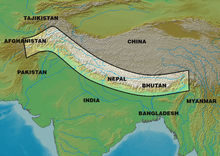
The Himalayas abut or cross five countries: Bhutan, India, Nepal, China, and Pakistan. The sovereignty of the range in the Kashmir region is disputed among India, Pakistan, and China.[3] The Himalayan range is bordered on the northwest by the Karakoram and Hindu Kush ranges, on the north by the Tibetan Plateau, and on the south by the Indo-Gangetic Plain. Some of the world's major rivers, the Indus, the Ganges, and the Tsangpo–Brahmaputra, rise in the vicinity of the Himalayas, and their combined drainage basin is home to some 600 million people; 53 million people live in the Himalayas.[4] The Himalayas have profoundly shaped the cultures of South Asia and Tibet. Many Himalayan peaks are sacred in Hinduism and Buddhism; the summits of several—Kangchenjunga (from the Indian side), Gangkhar Puensum, Machapuchare, Nanda Devi and Kailas in the Tibetan Transhimalaya—are off-limits to climbers.
Lifted by the subduction of the Indian tectonic plate under the Eurasian Plate, the Himalayan mountain range runs west-northwest to east-southeast in an arc 2,400 km (1,500 mi) long.[5] Its western anchor, Nanga Parbat, lies just south of the northernmost bend of the Indus river. Its eastern anchor, Namcha Barwa, lies immediately west of the great bend of the Yarlung Tsangpo River. The range varies in width from 350 km (220 mi) in the west to 150 km (93 mi) in the east.[6]
Name
The name of the range hails from the Sanskrit Himālaya (हिमालय 'abode of the snow'[7]), from himá (हिम 'snow'[8]) and ā-laya (आलय 'home, dwelling'[9]).[10][11] They are now known as "the Himalaya Mountains", usually shortened to "the Himalayas".
The mountains are known as the Himālaya in Nepali and Hindi (both written हिमालय), Himāl (हिमाल) in Kumaoni, the Himalaya (ཧི་མ་ལ་ཡ་) or 'The Land of Snow' (གངས་ཅན་ལྗོངས་) in Tibetan, also known as Himālaya in Sinhala written as හිමාලය, the Himāliya Mountain Range (سلسلہ کوہ ہمالیہ) in Urdu, the Himaloy Parvatmala (হিমালয় পর্বতমালা) in Bengali and the Ximalaya Mountain Range (simplified Chinese: 喜马拉雅山脉; traditional Chinese: 喜馬拉雅山脉; pinyin: Xǐmǎlāyǎ Shānmài) in Chinese.
The name of the range is sometimes also given as Himavan in older writings, including the Sanskrit epic Mahabharata.[12] Himavat (Sanskrit: हिमवत्) or Himavan Himavān (Sanskrit: हिमवान्) is a Hindu deity who is the personification of the Himalayan Mountain Range. Other epithets include Himaraja (Sanskrit: हिमराज, lit. 'king of snow') or Parvateshwara (Sanskrit: पर्वतेश्वर, lit. 'lord of mountains').
In western literature, some writers refer to it as the Himalaya. This was also previously transcribed as Himmaleh, as in Emily Dickinson's poetry[13] and Henry David Thoreau's essays.[14]
Geography and key features
The Himalayas consist of parallel mountain ranges: the Sivalik Hills on the south; the Lower Himalayan Range; the Great Himalayas, which is the highest and central range; and the Tibetan Himalayas on the north.[15] The Karakoram are generally considered separate from the Himalayas.
In the middle of the great curve of the Himalayan mountains lie the 8,000 m (26,000 ft) peaks of Dhaulagiri and Annapurna in Nepal, separated by the Kali Gandaki Gorge. The gorge splits the Himalayas into Western and Eastern sections both ecologically and orographically – the pass at the head of the Kali Gandaki the Kora La is the lowest point on the ridgeline between Everest and K2 (the highest peak of the Karakoram range). To the east of Annapurna are the 8,000 m (5.0 mi) peaks of Manaslu and across the border in Tibet, Shishapangma. To the south of these lies Kathmandu, the capital of Nepal and the largest city in the Himalayas. East of the Kathmandu Valley lies the valley of the Bhote/Sun Kosi river which rises in Tibet and provides the main overland route between Nepal and China – the Araniko Highway/China National Highway 318. Further east is the Mahalangur Himal with four of the world's six highest mountains, including the highest: Cho Oyu, Everest, Lhotse and Makalu. The Khumbu region, popular for trekking, is found here on the south-western approaches to Everest. The Arun river drains the northern slopes of these mountains, before turning south and flowing to the range to the east of Makalu.
In the far east of Nepal, the Himalayas rise to the Kangchenjunga massif on the border with India, the third highest mountain in the world, the most easterly 8,000 m (26,000 ft) summit and the highest point of India. The eastern side of Kangchenjunga is in the Indian state of Sikkim. Formerly an independent Kingdom, it lies on the main route from India to Lhasa, Tibet, which passes over the Nathu La pass into Tibet. East of Sikkim lies the ancient Buddhist Kingdom of Bhutan. The highest mountain in Bhutan is Gangkhar Puensum, which is also a strong candidate for the highest unclimbed mountain in the world. The Himalayas here are becoming increasingly rugged with heavily forested steep valleys. The Himalayas continue, turning slightly northeast, through the Indian State of Arunachal Pradesh as well as Tibet, before reaching their easterly conclusion in the peak of Namche Barwa, situated in Tibet inside the great bend of the Yarlang Tsangpo river. On the other side of the Tsangpo, to the east, are the Kangri Garpo mountains. The high mountains to the north of the Tsangpo including Gyala Peri, however, are also sometimes included in the Himalayas.
Going west from Dhaulagiri, Western Nepal is somewhat remote and lacks major high mountains, but is home to Rara Lake, the largest lake in Nepal. The Karnali River rises in Tibet but cuts through the centre of the region. Further west, the border with India follows the Sarda River and provides a trade route into China, where on the Tibetan plateau lies the high peak of Gurla Mandhata. Just across Lake Manasarovar from this lies the sacred Mount Kailash in the Kailash Ranges, which stands close to the source of the four main rivers of Himalayas and is revered in Hinduism, Buddhism, Sufism, Jainism, and Bonpo. In Uttarakhand, the Himalayas rise again as the Kumaon and Garhwal Himalayas[16] with the high peaks of Nanda Devi and Kamet. The state is also home to the important pilgrimage destinations of Chaar Dhaam, with Gangotri, the source of the holy river Ganges, Yamunotri, the source of the river Yamuna, and the temples at Badrinath and Kedarnath. Uttarakhand Himalayas are regionally divided into two, namely, Kumaon hills in Kumaon division and Garhwal hills in Garhwal division.[17]
The next Himalayan Indian state, Himachal Pradesh, is noted for its hill stations, particularly Shimla, the summer capital of the British Raj, and Dharamsala, the centre of the Tibetan community and government in exile in India. This area marks the start of the Punjab Himalaya and the Sutlej river, the most easterly of the five tributaries of the Indus, cuts through the range here. Further west, the Himalayas form much of the disputed Indian-administered union territory of Jammu and Kashmir where lies the renowned Kashmir Valley and the town and lakes of Srinagar. The Himalayas form most of the south-west portion of the disputed Indian-administered union territory of Ladakh. The twin peaks of Nun Kun are the only mountains over 7,000 m (4.3 mi) in this part of the Himalayas. Finally, the Himalayas reach their western end in the dramatic 8000 m peak of Nanga Parbat, which rises over 8,000 m (26,000 ft) above the Indus valley and is the most westerly of the 8000 m summits. The western end terminates at a magnificent point near Nanga Parbat where the Himalayas intersect with the Karakoram and Hindu Kush ranges, in the disputed Pakistani-administered territory of Gilgit-Baltistan. Some portion of the Himalayas, such as the Kaghan Valley, Margalla Hills and Galyat tract, extend into the Pakistani provinces of Khyber Pakhtunkhwa and Punjab.
Geology
![The 6,000-kilometre-plus (3,700 mi) journey of the India landmass (Indian Plate) before its collision with Asia (Eurasian Plate) about 40 to 50 million years ago[18]](http://upload.wikimedia.org/wikipedia/commons/thumb/2/2f/Himalaya-formation.gif/170px-Himalaya-formation.gif)
The Himalayan range is one of the youngest mountain ranges on the planet and consists mostly of uplifted sedimentary and metamorphic rock. According to the modern theory of plate tectonics, its formation is a result of a continental collision or orogeny along the convergent boundary (Main Himalayan Thrust) between the Indo-Australian Plate and the Eurasian Plate. The Arakan Yoma highlands in Myanmar and the Andaman and Nicobar Islands in the Bay of Bengal were also formed as a result of this collision.
During the Upper Cretaceous, about 70 million years ago, the north-moving Indo-Australian Plate (which has subsequently broken into the Indian Plate and the Australian Plate[19]) was moving at about 15 cm (5.9 in) per year. About 50 million years ago this fast-moving Indo-Australian Plate had completely closed the Tethys Ocean, the existence of which has been determined by sedimentary rocks settled on the ocean floor and the volcanoes that fringed its edges. Since both plates were composed of low density continental crust, they were thrust faulted and folded into mountain ranges rather than subducting into the mantle along an oceanic trench.[18] An often-cited fact used to illustrate this process is that the summit of Mount Everest is made of marine limestone from this ancient ocean.[20]
Today, the Indian plate continues to be driven horizontally at the Tibetan Plateau, which forces the plateau to continue to move upwards.[21] The Indian plate is still moving at 67 mm per year, and over the next 10 million years it will travel about 1,500 km (930 mi) into Asia. About 20 mm per year of the India-Asia convergence is absorbed by thrusting along the Himalaya southern front. This leads to the Himalayas rising by about 5 mm per year, making them geologically active. The movement of the Indian plate into the Asian plate also makes this region seismically active, leading to earthquakes from time to time.
During the last ice age, there was a connected ice stream of glaciers between Kangchenjunga in the east and Nanga Parbat in the west.[22][23] In the west, the glaciers joined with the ice stream network in the Karakoram, and in the north, they joined with the former Tibetan inland ice. To the south, outflow glaciers came to an end below an elevation of 1,000–2,000 m (3,300–6,600 ft).[22][24] While the current valley glaciers of the Himalaya reach at most 20 to 32 km (12 to 20 mi) in length, several of the main valley glaciers were 60 to 112 km (37 to 70 mi) long during the ice age.[22] The glacier snowline (the altitude where accumulation and ablation of a glacier are balanced) was about 1,400–1,660 m (4,590–5,450 ft) lower than it is today. Thus, the climate was at least 7.0 to 8.3 °C (12.6 to 14.9 °F) colder than it is today.[25]
Hydrology

Despite their scale, the Himalayas do not form a major watershed, and a number of rivers cut through the range, particularly in the eastern part of the range. As a result, the main ridge of the Himalayas is not clearly defined, and mountain passes are not as significant for traversing the range as with other mountain ranges. The rivers of the Himalayas drain into two large river systems:
- The western rivers combine into the Indus Basin. The Indus itself forms the northern and western boundaries of the Himalayas. It begins in Tibet at the confluence of Sengge and Gar rivers and flows north-west through India into Pakistan before turning south-west to the Arabian Sea. It is fed by several major tributaries draining the southern slopes of the Himalayas, including the Jhelum, Chenab, Ravi, Beas and Sutlej rivers, the five rivers of the Punjab.
- The other Himalayan rivers drain the Ganges-Brahmaputra Basin. Its main rivers are the Ganges, the Brahmaputra and the Yamuna, as well as other tributaries. The Brahmaputra originates as the Yarlung Tsangpo River in western Tibet, and flows east through Tibet and west through the plains of Assam. The Ganges and the Brahmaputra meet in Bangladesh and drain into the Bay of Bengal through the world's largest river delta, the Sunderbans.[26]
The northern slopes of Gyala Peri and the peaks beyond the Tsangpo, sometimes included in the Himalayas, drain into the Irrawaddy River, which originates in eastern Tibet and flows south through Myanmar to drain into the Andaman Sea. The Salween, Mekong, Yangtze and Yellow River all originate from parts of the Tibetan Plateau that are geologically distinct from the Himalaya mountains and are therefore not considered true Himalayan rivers. Some geologists refer to all the rivers collectively as the circum-Himalayan rivers.[27]
Glaciers
The great ranges of central Asia, including the Himalayas, contain the third-largest deposit of ice and snow in the world, after Antarctica and the Arctic.[28] The Himalayan range encompasses about 15,000 glaciers, which store about 12,000 km3 (2,900 cu mi) of fresh water.[29] Its glaciers include the Gangotri and Yamunotri (Uttarakhand) and Khumbu glaciers (Mount Everest region), Langtang glacier (Langtang region) and Zemu (Sikkim).

Owing to the mountains' latitude near the Tropic of Cancer, the permanent snow line is among the highest in the world at typically around 5,500 m (18,000 ft).[30] In contrast, equatorial mountains in New Guinea, the Rwenzoris and Colombia have a snow line some 900 m (2,950 ft) lower.[31] The higher regions of the Himalayas are snowbound throughout the year, in spite of their proximity to the tropics, and they form the sources of several large perennial rivers.
In recent years, scientists have monitored a notable increase in the rate of glacier retreat across the region as a result of climate change.[32][33] For example, glacial lakes have been forming rapidly on the surface of debris-covered glaciers in the Bhutan Himalaya during the last few decades. Although the effect of this will not be known for many years, it potentially could mean disaster for the hundreds of millions of people who rely on the glaciers to feed the rivers during the dry seasons.[34][35][36] The global climate change will affect the water resources and livelihoods of the Greater Himalayan region.
Lakes

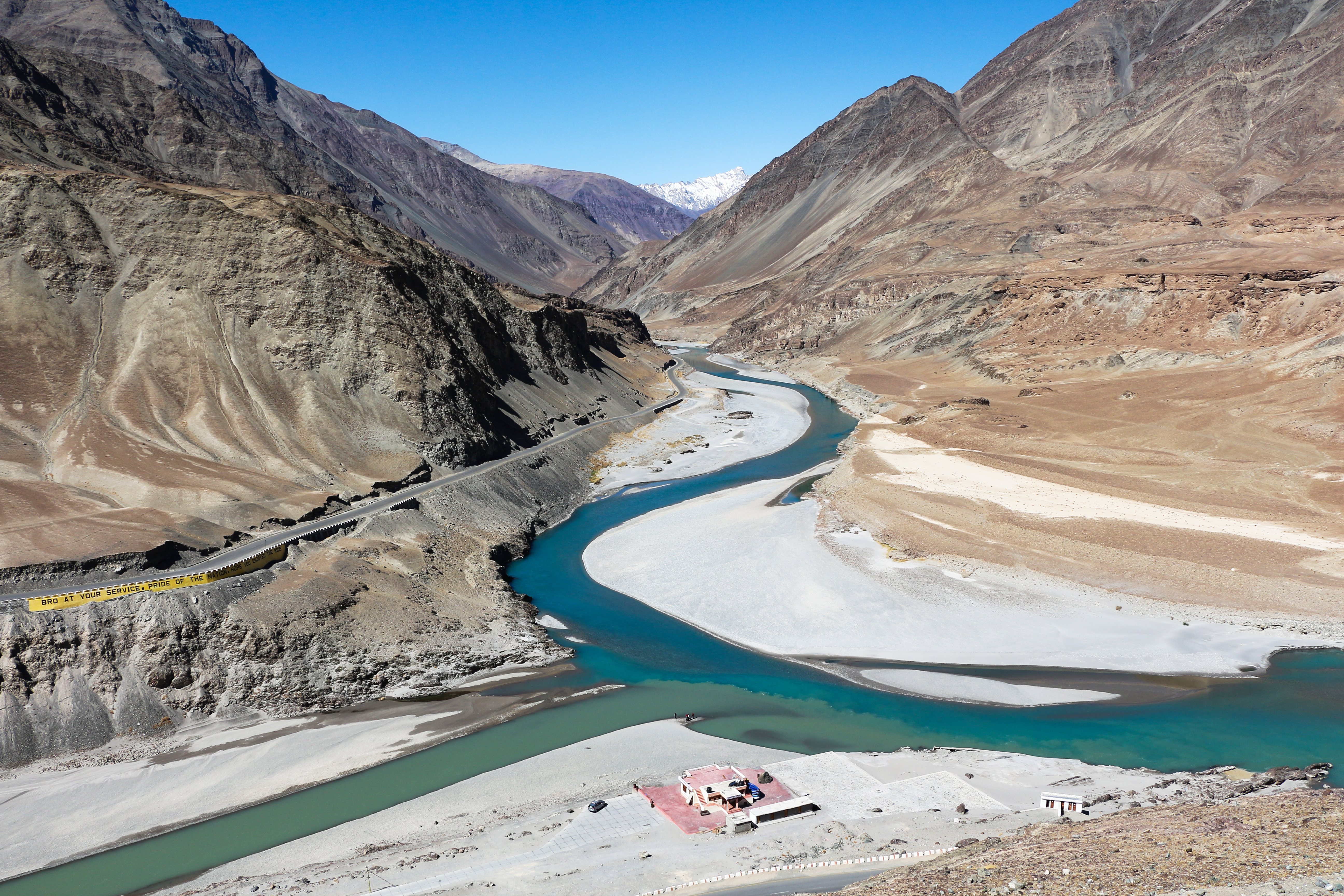
The Himalayan region is dotted with hundreds of lakes.[37] Pangong Tso, which is spread across the border between India and China, at far western end of Tibet, is among the largest with surface areas of 700 km2 (270 sq mi).
South of the main range, the lakes are smaller. Tilicho Lake in Nepal in the Annapurna massif is one of the highest lakes in the world. Other notable lakes include Rara Lake in western Nepal, She-Phoksundo Lake in the Shey Phoksundo National Park of Nepal, Gurudongmar Lake, in North Sikkim, Gokyo Lakes in Solukhumbu district of Nepal and Lake Tsongmo, near the Indo-China border in Sikkim.[37]
Some of the lakes present a danger of a glacial lake outburst flood. The Tsho Rolpa glacier lake in the Rowaling Valley, in the Dolakha District of Nepal, is rated as the most dangerous. The lake, which is located at an altitude of 4,580 m (15,030 ft) has grown considerably over the last 50 years due to glacial melting.[38][39] The mountain lakes are known to geographers as tarns if they are caused by glacial activity. Tarns are found mostly in the upper reaches of the Himalaya, above 5,500 m (18,000 ft).[40]
Temperate Himalayan wetlands provide important habitat and layover sites for migratory birds. Many mid and low altitude lakes remain poorly studied in terms of their hydrology and biodiversity, like Khecheopalri in the Sikkim Eastern Himalayas.[41]
Climate
Temperature
The physical factors determining the climate in any location in the Himalayas include latitude, altitude, and the relative motion of the Southwest monsoon.[42] From south to north, the mountains cover more than eight degrees of latitude, spanning temperate to subtropical zones.[42] The colder air of Central Asia is prevented from blowing down into South Asia by the physical configuration of the Himalayas.[42] This causes the tropical zone to extend farther north in South Asia than anywhere else in the world.[42] The evidence is unmistakable in the Brahmaputra valley as the warm air from the Bay of Bengal bottlenecks and rushes up past Namcha Barwa, the eastern anchor of the Himalayas, and into southeastern Tibet.[42] Temperatures in the Himalayas cool by 2.0 degrees C (3.6 degrees F) for every 300 metres (980 ft) increase of altitude.[42]
As the physical features of mountains are irregular, with broken jagged contours, there can be wide variations in temperature over short distances.[43] Temperature at a location on a mountain depends on the season of the year, the bearing of the sun with respect to the face on which the location lies, and the mass of the mountain, i.e. the amount of matter in the mountain.[43] As the temperature is directly proportional to received radiation from the sun, the faces that receive more direct sunlight also have a greater heat buildup.[43] In narrow valleys—lying between steep mountain faces—there can be dramatically different weather along their two margins.[43] The side to the north with a mountain above facing south can have an extra month of the growing season.[43] The mass of the mountain also influences the temperature, as it acts as a heat island, in which more heat is absorbed and retained than the surroundings, and therefore influences the heat budget or the amount of heat needed to raise the temperature from the winter minimum winter to the summer maximum.[43] The immense scale of the Himalayas means that many summits can create their own weather, the temperature fluctuating from one summit to another, from one face to another, and all may be quite different from the weather in nearby plateaus or valleys.[43]
Precipitation
A critical influence on the Himalayan climate is the Southwest Monsoon. This is not so much the rain of the summer months as the wind that carries the rain.[43] Different rates of heating and cooling between the Central Asian continent and the South Asian ocean create large differences in the atmospheric pressure prevailing above each.[43] In the winter, a high-pressure system forms and remains suspended above Central Asia, forcing air to flow in the southerly direction over the Himalayas.[43] But in Central Asia as there is no substantial source for water to be diffused as vapour, the winter winds blowing across South Asia are dry.[43] In the summer months the Central Asian plateau heats up more than the ocean waters to its south. As a result, the air above it rises higher and higher, creating a zone of low pressure.[43] Off-shore high-pressure systems in the Indian Ocean push the moist summer air inland toward the low-pressure system. When the moist air meets mountains, it rises and upon subsequent cooling, its moisture condenses and is released as rain, typically heavy rain.[43] The wet summer monsoon winds cause precipitation in India and all along the layered southern slopes of the Himalayas. This forced lifting of air is called the orographic effect.[43]
Winds
The vast size, huge altitude range, and complex topography of the Himalayas mean they experience a wide range of climates, from humid subtropical in the foothills to cold and dry desert conditions on the Tibetan side of the range. For much of the Himalayas—in the areas to the south of the high mountains, the monsoon is the most characteristic feature of the climate and causes most of the precipitation, while the western disturbance brings winter precipitation, especially in the west. Heavy rain arrives on the southwest monsoon in June and persists until September. The monsoon can seriously impact transport and cause major landslides. It restricts tourism – the trekking and mountaineering season is limited to either before the monsoon in April/May or after the monsoon in October/November (autumn). In Nepal and Sikkim, there are often considered to be five seasons: summer, monsoon, autumn, (or post-monsoon), winter, and spring.
Using the Köppen climate classification, the lower elevations of the Himalayas, reaching in mid-elevations in central Nepal (including the Kathmandu valley), are classified as Cwa, Humid subtropical climate with dry winters. Higher up, most of the Himalayas have a subtropical highland climate (Cwb).
The intensity of the southwest monsoon diminishes as it moves westward along the range, with as much as 2,030 mm (80 in) of rainfall in the monsoon season in Darjeeling in the east, compared to only 975 mm (38.4 in) during the same period in Shimla in the west.[44][45]
The northern side of the Himalayas, also known as the Tibetan Himalaya, is dry, cold and, generally, windswept particularly in the west where it has a cold desert climate. The vegetation is sparse and stunted and the winters are severely cold. Most of the precipitation in the region is in the form of snow during the late winter and spring months.
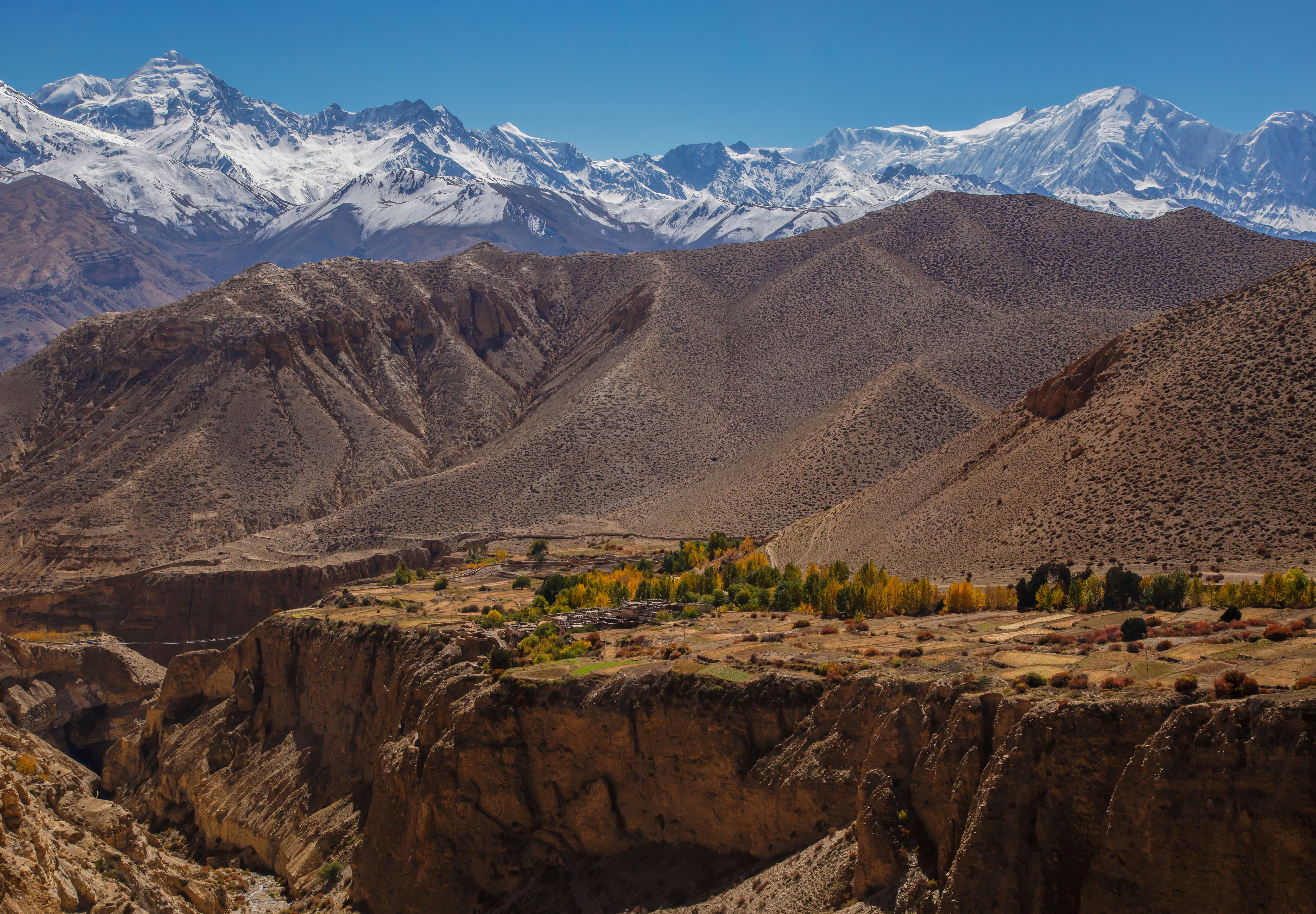

Local impacts on climate are significant throughout the Himalayas. Temperatures fall by 0.2 to 1.2 °C for every 100 m (330 ft) rise in altitude.[46] This gives rise to a variety of climates from a nearly tropical climate in the foothills, to tundra and permanent snow and ice at higher elevations. Local climate is also affected by the topography: The leeward side of the mountains receive less rain while the well exposed slopes get heavy rainfall and the rain shadow of large mountains can be significant, for example leading to near desert conditions in the Upper Mustang which is sheltered from the monsoon rains by the Annapurna and Dhaulagiri massifs and has annual precipitation of around 300 mm (12 in), while Pokhara on the southern side of the massifs has substantial rainfall (3,900 mm or 150 in a year). Thus although annual precipitation is generally higher in east than the west, local variations are often more important.
The Himalayas have a profound effect on the climate of the Indian subcontinent and the Tibetan Plateau. They prevent frigid, dry winds from blowing south into the subcontinent, which keeps South Asia much warmer than corresponding temperate regions in the other continents. It also forms a barrier for the monsoon winds, keeping them from traveling northwards, and causing heavy rainfall in the Terai region. The Himalayas are also believed to play an important part in the formation of Central Asian deserts, such as the Taklamakan and Gobi.[47]
Climate change
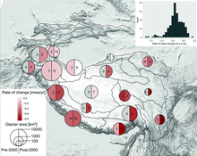
The 2019 Hindu Kush Himalaya Assessment[48] concluded that between 1901 to 2014, the Hindu Kush Himalaya (or HKH) region had already experienced warming of 0.1 °C per decade, with the warming rate accelerating to 0.2 °C per decade over the past 50 years.Over the past 50 years, the frequency of warm days and nights had also increased by 1.2 days and 1.7 nights per decade, while the frequency of extreme warm days and nights had increased by 1.26 days and 2.54 nights per decade. There was also a corresponding decline of 0.5 cold days, 0.85 extreme cold days, 1 cold night, and 2.4 extreme cold nights per decade. The length of the growing season has increased by 4.25 days per decade. There is less conclusive evidence of light precipitation becoming less frequent while heavy precipitation became both more frequent and more intense. Finally, since 1970s glaciers have retreated everywhere in the region beside Karakoram, eastern Pamir, and western Kunlun, where there has been an unexpected increase in snowfall. Glacier retreat had been followed by an increase in the number of glacial lakes, some of which may be prone to dangerous floods.[49]
In the future, if the Paris Agreement goal of 1.5 °C of global warming is not exceeded, warming in the HKH will be at least 0.3 °C higher, and at least 0.7 °C higher in the hotspots of northwest Himalaya and Karakoram. If the Paris Agreement goals are broken, then the region is expected to warm by 1.7–2.4 °C in the near future (2036–2065) and by 2.2–3.3 °C (2066–2095) near the end of the century under the "intermediate" Representative Concentration Pathway 4.5 (RCP4.5). Under the high-warming RCP8.5 scenario where the annual emissions continue to increase for the rest of the century, the expected regional warming is 2.3–3.2 °C and 4.2–6.5 °C, respectively. Under all scenarios, winters will warm more than the summers, and the Tibetan Plateau, the central Himalayan Range, and the Karakoram will continue to warm more than the rest of the region. Climate change will also lead to the degradation of up to 81% of the region's permafrost by the end of the century.[49]
Future precipitation is projected to increase as well, but CMIP5 models struggle to make specific projections due to the region's topography: the most certain finding is that the monsoon precipitation in the region will increase by 4–12% in the near future and by 4–25% in the long term.[49] There has also been modelling of the changes in snow cover, but it is limited to the end of century under the RCP 8.5 scenario: it projects declines of 30–50% in the Indus Basin, 50–60% in the Ganges basin, and 50–70% in the Brahmaputra Basin, as the snowline elevation in these regions will rise by between 4.4 and 10.0 m/yr. There has been more extensive modelling of glacier trends: it is projected that one third of all glaciers in the extended HKH region will be lost by 2100 even if the warming is limited to 1.5 °C (with over half of that loss in the Eastern Himalaya region), while RCP 4.5 and RCP 8.5 are likely to lead to the losses of 50% and >67% of the region's glaciers over the same timeframe. Glacier melt is projected to accelerate regional river flows until the amount of meltwater peaks around 2060, going into an irreversible decline afterwards. Since precipitation will continue to increase even as the glacier meltwater contribution declines, annual river flows are only expected to diminish in the western basins where contribution from the monsoon is low: however, irrigation and hydropower generation would still have to adjust to greater interannual variability and lower pre-monsoon flows in all of the region's rivers.[50][51][52]Ecology

The flora and fauna of the Himalayas vary with climate, rainfall, altitude, and soils. The climate ranges from tropical at the base of the mountains to permanent ice and snow at the highest elevations. The amount of yearly rainfall increases from west to east along the southern front of the range. This diversity of altitude, rainfall, and soil conditions combined with the very high snow line supports a variety of distinct plant and animal communities.[37] The extremes of high altitude (low atmospheric pressure) combined with extreme cold favor extremophile organisms.[53][41]
At high altitudes, the elusive and previously endangered snow leopard is the main predator. Its prey includes members of the goat family grazing on the alpine pastures and living on the rocky terrain, notably the endemic bharal or Himalayan blue sheep. The Himalayan musk deer is also found at high altitudes. Hunted for its musk, it is now rare and endangered. Other endemic or near-endemic herbivores include the Himalayan tahr, the takin, the Himalayan serow, and the Himalayan goral. The critically endangered Himalayan subspecies of the brown bear is found sporadically across the range as is the Asian black bear. In the mountainous mixed deciduous and conifer forests of the eastern Himalayas, Red panda feed in the dense understories of bamboo. Lower down the forests of the foothills are inhabited by several different primates, including the endangered Gee's golden langur and the Kashmir gray langur, with highly restricted ranges in the east and west of the Himalayas respectively.[41]
The unique floral and faunal wealth of the Himalayas is undergoing structural and compositional changes due to climate change. Hydrangea hirta is an example of floral species that can be found in this area. The increase in temperature is shifting various species to higher elevations. The oak forest is being invaded by pine forests in the Garhwal Himalayan region. There are reports of early flowering and fruiting in some tree species, especially rhododendron, apple and box myrtle. The highest known tree species in the Himalayas is Juniperus tibetica located at 4,900 m (16,080 ft) in Southeastern Tibet.[54]
Religions


There are many cultural and mythological aspects associated with the Himalayas. In Jainism, Mount Ashtapad of the Himalayan mountain range, is a sacred place where the first Jain Tirthankara, Rishabhdeva attained moksha. It is believed that after Rishabhdeva attained nirvana, his son, Emperor Bharata Chakravartin, had constructed three stupas and twenty four shrines of the 24 Tirthankaras with their idols studded with precious stones over there and named it Sinhnishdha.[56][57][58] For the Hindus, the Himalayas are personified as Himavat, king of all mountains and the father of the goddess Parvati.[59] The Himalayas are also considered to be the father of Ganga (the personification of river Ganges).[60] Two of the most sacred places of pilgrimage for the Hindus are the temple complex in Pashupatinath and Muktinath, also known as Saligrama because of the presence of the sacred black rocks called saligrams.[61]
The Buddhists also lay a great deal of importance on the Himalayas. Paro Taktsang is the holy place where Buddhism started in Bhutan.[62] The Muktinath is also a place of pilgrimage for the Tibetan Buddhists. They believe that the trees in the poplar grove came from the walking sticks of eighty-four ancient Indian Buddhist magicians or mahasiddhas. They consider the saligrams to be representatives of the Tibetan serpent deity known as Gawo Jagpa.[63] The Himalayan people's diversity shows in many different ways. It shows through their architecture, their languages, and dialects, their beliefs and rituals, as well as their clothing.[63] The shapes and materials of the people's homes reflect their practical needs and beliefs. Another example of the diversity amongst the Himalayan peoples is that handwoven textiles display colors and patterns unique to their ethnic backgrounds. Finally, some people place great importance on jewelry. The Rai and Limbu women wear big gold earrings and nose rings to show their wealth through their jewelry.[63] Several places in the Himalayas are of religious significance in Hinduism, Buddhism, Jainism and Sikhism. A notable example of a religious site is Paro Taktsang, where Padmasambhava is said to have founded Buddhism in Bhutan.[64]
A number of Vajrayana Buddhist sites are situated in the Himalayas, in Tibet, Bhutan and in the Indian regions of Ladakh, Sikkim, Arunachal Pradesh, Spiti and Darjeeling. There were over 6,000 monasteries in Tibet, including the residence of the Dalai Lama.[65] Bhutan, Sikkim and Ladakh are also dotted with numerous monasteries.
Resources
The Himalayas are home to a diversity of medicinal resources. Plants from the forests have been used for millennia to treat conditions ranging from simple coughs to snake bites.[61] Different parts of the plants – root, flower, stem, leaves, and bark – are used as remedies for different ailments. For example, a bark extract from an Abies pindrow tree is used to treat coughs and bronchitis. Leaf and stem paste from an Andrachne cordifolia is used for wounds and as an antidote for snake bites. The bark of a Callicarpa arborea is used for skin ailments.[61] Nearly a fifth of the gymnosperms, angiosperms and pteridophytes in the Himalayas are found to have medicinal properties, and more are likely to be discovered.[61]
Most of the population in some Asian and African countries depends on medicinal plants rather than prescriptions and such.[59] Since so many people use medicinal plants as their only source of healing in the Himalayas, the plants are an important source of income. This contributes to economic and modern industrial development both inside and outside the region.[59] The only problem is that locals are rapidly clearing the forests on the Himalayas for wood, often illegally.[66]
See also
- Eastern and Western Himalaya
- Indian Himalayan Region
- List of Himalayan peaks and passes
- List of Himalayan topics
- List of mountains in India, Pakistan, Bhutan, Nepal and China
- List of Ultras of the Himalayas
- Trekking peak
References
- "Himalayan". Oxford English Dictionary (Online ed.). Oxford University Press. Retrieved 5 August 2021.
Etymology: < Himālaya (Sanskrit < hima snow + ālaya dwelling, abode) + -an suffix)
(Subscription or participating institution membership required.) - Yang, Qinye; Zheng, Du (2004). Himalayan Mountain System. ISBN 978-7-5085-0665-4. Retrieved 30 July 2016.
- Bishop, Barry. "Himalayas (mountains, Asia)". Encyclopaedia Britannica. Retrieved 30 July 2016.
- A.P. Dimri; B. Bookhagen; M. Stoffel; T. Yasunari (8 November 2019). Himalayan Weather and Climate and their Impact on the Environment. Springer Nature. p. 380. ISBN 978-3-030-29684-1.
- Wadia, D. N. (1931). "The syntaxis of the northwest Himalaya: its rocks, tectonics and orogeny". Record Geol. Survey of India. 65 (2): 189–220.
- Apollo, M. (2017). "Chapter 9: The population of Himalayan regions – by the numbers: Past, present and future". In Efe, R.; Öztürk, M. (eds.). Contemporary Studies in Environment and Tourism. Cambridge Scholars Publishing. pp. 143–159.
- "MW Cologne Scan". www.sanskrit-lexicon.uni-koeln.de. Retrieved 27 March 2022.
- "MW Cologne Scan". www.sanskrit-lexicon.uni-koeln.de. Retrieved 27 March 2022.
- "WIL Cologne Scan". www.sanskrit-lexicon.uni-koeln.de. Retrieved 27 March 2022.
- "BEN Cologne Scan". www.sanskrit-lexicon.uni-koeln.de. Retrieved 27 March 2022.
- "WIL Cologne Scan". www.sanskrit-lexicon.uni-koeln.de. Retrieved 27 March 2022.
- Roshen Dalal (2014). Hinduism: An Alphabetical Guide. Penguin Books. ISBN 9788184752779. Entry: "Himavan"
- Dickinson, Emily, The Himmaleh was known to stoop.
- Thoreau, Henry David (1849), A Week on the Concord and Merrimack Rivers.
- Bishop, Barry C.; Chatterjee, Shiba P. Himalayas. Encyclopedia Britannica.
- Pletcher, Kenneth (13 March 2009). "Kumaun Himalayas". Encyclopedia Britannica.
- "Division of the Himalayas: Regional Division of the Himalayas on the Basis of River Valleys". 21 November 2013.
- "The Himalayas: Two continents collide". USGS. 5 May 1999. Retrieved 3 January 2015.
- "Geologists Find: An Earth Plate Is Breaking in Two". Columbia University. 7 July 1995.
- Mount Everest – Overview and Information by Matt Rosenberg. ThoughtCo Updated 17 March 2017
- "Plate Tectonics -The Himalayas". The Geological Society. Retrieved 13 September 2016.
- Kuhle, M. (2011). "The High Glacial (Last Ice Age and Last Glacial Maximum) Ice Cover of High and Central Asia, with a Critical Review of Some Recent OSL and TCN Dates". In Ehlers, J.; Gibbard, P.L.; Hughes, P.D. (eds.). Quaternary Glaciation – Extent and Chronology, A Closer Look. Amsterdam: Elsevier BV. pp. 943–965.
- glacier maps downloadable
- Kuhle, M. (1987). "Subtropical mountain- and highland-glaciation as ice age triggers and the waning of the glacial periods in the Pleistocene". GeoJournal. 14 (4): 393–421. doi:10.1007/BF02602717. S2CID 129366521.
- Kuhle, M. (2005). "The maximum Ice Age (Würmian, Last Ice Age, LGM) glaciation of the Himalaya – a glaciogeomorphological investigation of glacier trim-lines, ice thicknesses and lowest former ice margin positions in the Mt. Everest-Makalu-Cho Oyu massifs (Khumbu- and Khumbakarna Himal) including information on late-glacial-, neoglacial-, and historical glacier stages, their snow-line depressions and ages". GeoJournal. 62 (3–4): 193–650. doi:10.1007/s10708-005-2338-6.
- "Sunderbans the world's largest delta". gits4u.com. Archived from the original on 3 January 2015. Retrieved 3 January 2015.
- Gaillardet, J.; Métivier, F.; Lemarchand, D.; Dupré, B.; Allègre, C.J.; Li, W.; Zhao, J. (2003). "Geochemistry of the Suspended Sediments of Circum-Himalayan Rivers and Weathering Budgets over the Last 50 Myrs" (PDF). Geophysical Research Abstracts. 5: 13,617. Bibcode:2003EAEJA....13617G. Abstract 13617. Archived (PDF) from the original on 9 October 2022. Retrieved 4 November 2006.
- "The Himalayas – Himalayas Facts". Nature on PBS. 11 February 2011. Retrieved 21 January 2014.
- "the Himalayan Glaciers". Fourth assessment report on climate change. IPPC. 2007. Retrieved 22 January 2014.
- Shi, Yafeng; Xie, Zizhu; Zheng, Benxing; Li, Qichun (1978). "Distribution, Feature and Variations of Glaciers in China" (PDF). World Glacier Inventory. Archived from the original (PDF) on 24 April 2013.
- Henderson-Sellers, Ann; McGuffie, Kendal (2012). The Future of the World's Climate: A Modelling Perspective. pp. 199–201. ISBN 978-0-12-386917-3.
- Lee, Ethan; Carrivick, Jonathan L.; Quincey, Duncan J.; Cook, Simon J.; James, William H. M.; Brown, Lee E. (20 December 2021). "Accelerated mass loss of Himalayan glaciers since the Little Ice Age". Scientific Reports. 11 (1): 24284. Bibcode:2021NatSR..1124284L. doi:10.1038/s41598-021-03805-8. ISSN 2045-2322. PMC 8688493. PMID 34931039.
- "Vanishing Himalayan Glaciers Threaten a Billion". Reuters. 4 June 2007. Retrieved 13 March 2018.
- Kaushik, Saurabh; Rafiq, Mohammd; Joshi, P.K.; Singh, Tejpal (April 2020). "Examining the glacial lake dynamics in a warming climate and GLOF modelling in parts of Chandra basin, Himachal Pradesh, India". Science of the Total Environment. 714: 136455. Bibcode:2020ScTEn.714m6455K. doi:10.1016/j.scitotenv.2019.136455. PMID 31986382. S2CID 210933887.
- Rafiq, Mohammd; Romshoo, Shakil Ahmad; Mishra, Anoop Kumar; Jalal, Faizan (January 2019). "Modelling Chorabari Lake outburst flood, Kedarnath, India". Journal of Mountain Science. 16 (1): 64–76. doi:10.1007/s11629-018-4972-8. ISSN 1672-6316. S2CID 134015944.
- "Glaciers melting at alarming speed". People's Daily Online. 24 July 2007. Retrieved 17 April 2009.
- O'Neill, A. R. (2019). "Evaluating high-altitude Ramsar wetlands in the Sikkim Eastern Himalayas". Global Ecology and Conservation. 20 (e00715): 19. doi:10.1016/j.gecco.2019.e00715.
- "Photograph of Tsho Rolpa".
- Tsho Rolpa
- Drews, Carl. "Highest Lake in the World". Retrieved 14 November 2010.
- O'Neill, Alexander; et al. (25 February 2020). "Establishing Ecological Baselines Around a Temperate Himalayan Peatland". Wetlands Ecology & Management. 28 (2): 375–388. doi:10.1007/s11273-020-09710-7. S2CID 211081106.
- Zurick & Pacheco 2006, p. 50.
- Zurick & Pacheco 2006, pp. 50–51.
- "Climate of the Himalayas". Encyclopedia Britannica. Retrieved 18 May 2022.
- Zurick, David; Pocheco, Julsun (2006), Illustrated Atlas of the Himalaya, University Press of Kentucky, p. 52, ISBN 9780813173849
- Romshoo, Shakil Ahmad; Rafiq, Mohammd; Rashid, Irfan (March 2018). "Spatio-temporal variation of land surface temperature and temperature lapse rate over mountainous Kashmir Himalaya". Journal of Mountain Science. 15 (3): 563–576. doi:10.1007/s11629-017-4566-x. ISSN 1672-6316. S2CID 134568990.
- Devitt, Terry (3 May 2001). "Climate shift linked to rise of Himalayas, Tibetan Plateau". University of Wisconsin–Madison News. Retrieved 1 November 2011.
- Wester, Philippus; Mishra, Arabinda; Mukherji, Aditi; Shrestha, Arun Bhakta (2019). The Hindu Kush Himalaya Assessment: Mountains, Climate Change, Sustainability and People. doi:10.1007/978-3-319-92288-1. ISBN 978-3-319-92288-1. }}
- Krishnan, Raghavan; Shrestha, Arun Bhakta; Ren, Guoyu; Rajbhandari, Rupak; Saeed, Sajjad; Sanjay, Jayanarayanan; Syed, Md. Abu.; Vellore, Ramesh; Xu, Ying; You, Qinglong; Ren, Yuyu (5 January 2019). "Unravelling Climate Change in the Hindu Kush Himalaya: Rapid Warming in the Mountains and Increasing Extremes". The Hindu Kush Himalaya Assessment: Mountains, Climate Change, Sustainability and People. pp. 57–97. doi:10.1007/978-3-319-92288-1_3.
- Damian Carrington (4 February 2019). "A third of Himalayan ice cap doomed, finds report". Retrieved 20 October 2022.
- Bolch, Tobias; Shea, Joseph M.; Liu, Shiyin; Azam, Farooq M.; Gao, Yang; Gruber, Stephan; Immerzeel, Walter W.; Kulkarni, Anil; Li, Huilin; Tahir, Adnan A.; Zhang, Guoqing; Zhang, Yinsheng (5 January 2019). "Status and Change of the Cryosphere in the Extended Hindu Kush Himalaya Region". The Hindu Kush Himalaya Assessment: Mountains, Climate Change, Sustainability and People. pp. 209–255. doi:10.1007/978-3-319-92288-1_7.
- Scott, Christopher A.; Zhang, Fan; Mukherji, Aditi; Immerzeel, Walter; Mustafa, Daanish; Bharati, Luna (5 January 2019). "Water in the Hindu Kush Himalaya". The Hindu Kush Himalaya Assessment: Mountains, Climate Change, Sustainability and People. pp. 257–299. doi:10.1007/978-3-319-92288-1_8.
- Hogan, C. Michael (2010). Monosson, E. (ed.). "Extremophile". Encyclopedia of Earth. Washington, DC: National Council for Science and the Environment.
- Miehe, Georg; Miehe, Sabine; Vogel, Jonas; Co, Sonam; Duo, La (May 2007). "Highest Treeline in the Northern Hemisphere Found in Southern Tibet" (PDF). Mountain Research and Development. 27 (2): 169–173. doi:10.1659/mrd.0792. hdl:1956/2482. S2CID 6061587. Archived from the original (PDF) on 6 June 2013.
- Ehsan Yarshater (2003). Encyclopædia Iranica. The Encyclopaedia Iranica Foundation. p. 312. ISBN 978-0-933273-76-4.
- Jain, Arun Kumar (2009). Faith & Philosophy of Jainism. ISBN 978-81-7835-723-2.
- "To heaven and back". The Times of India. 11 January 2012. Archived from the original on 7 July 2012. Retrieved 2 March 2012.
- Jain, Arun Kumar (2009). Faith & Philosophy of Jainism. ISBN 978-81-7835-723-2.
- Gupta, Pankaj; Sharma, Vijay Kumar (2014). Healing Traditions of the Northwestern Himalayas. Springer Briefs in Environmental Science. ISBN 978-81-322-1925-5.
- Dallapiccola, Anna (2002). Dictionary of Hindu Lore and Legend. ISBN 978-0-500-51088-9.
- Jahangeer A. Bhat; Munesh Kumar; Rainer W. Bussmann (2 January 2013). "Ecological status and traditional knowledge of medicinal plants in Kedarnath Wildlife Sanctuary of Garhwal Himalaya, India". Journal of Ethnobiology and Ethnomedicine. 9: 1. doi:10.1186/1746-4269-9-1. PMC 3560114. PMID 23281594.
- Cantor, Kimberly (14 July 2016). "Paro, Bhutan: The Tiger's Nest". Huffington Post. Retrieved 9 June 2018.
- Zurick, David; Julsun, Pacheco; Basanta, Raj Shrestha; Birendra, Bajracharya (2006). Illustrated Atlas of the Himalaya. Lexington: U of Kentucky.
- Pommaret, Francoise (2006). Bhutan Himalayan Mountains Kingdom (5th ed.). Odyssey Books and Guides. pp. 136–137. ISBN 978-962-217-810-6.
- "Tibetan monks: A controlled life". BBC News. 20 March 2008.
- "Himalayan Forests Disappearing". Earth Island Journal. 21 (4): 7–8. 2006.
Sources
General
- Wester, Philippus; Mishra, Arabinda; Mukherji, Aditi; Shrestha, Arun Bhakta, eds. (2019), The Hindu Kush Himalya Assessment: Mountains, Climate Change, Sustainability and People, Springer Open, ICIMOD, HIMAP, ISBN 978-3-319-92287-4, LCCN 2018954855
- Zurick, David; Pacheco, Julsun (2006), Illustrated Atlas of the Himalayas, with Basanta Shrestha and Birendra Bajracharya, Lexington: University Press of Kentucky, ISBN 9780813123882, OCLC 1102237054
Geology
- Chakrabarti, B. K. (2016). Geology of the Himalayan Belt: Deformation, Metamorphism, Stratigraphy. Amsterdam and Boston: Elsevier. ISBN 978-0-12-802021-0.
- Davies, Geoffrey F. (2022). Stories from the Deep Earth: How Scientists Figured Out What Drives Tectonic Plates and Mountain Building. Cham, Switzerland: Springer Nature. doi:10.1007/978-3-030-91359-5. ISBN 978-3-030-91358-8.
- Frisch, Wolfgang; Meschede, Martin; Blakey, Ronald (2011). Plate Tectonics: Continental Drift and Mountain Building. Heidelberg: Springer. doi:10.1007/978-3-540-76504-2. ISBN 978-3-540-76503-5.
Climate
- Clift, Peter D.; Plumb, R. Alan (2008), The Asian Monsoon: Causes, History and Effects, Cambridge and New York: Cambridge University Press, ISBN 978-0-521-84799-5
- Barry, Roger E (2008), Mountain Weather and Climate (3rd ed.), Cambridge and New York: Cambridge University Press, ISBN 978-0-521-86295-0
Ecology
Society
Pilgrimage and Tourism
- Bleie, Tone (2003), "Pilgrim Tourism in the Central Himalayas: The Case of Manakamana Temple in Gorkha, Nepal", Mountain Research and Development, International Mountain Society, 23 (2): 177–184, doi:10.1659/0276-4741(2003)023[0177:PTITCH]2.0.CO;2, S2CID 56120507
- Howard, Christopher A (2016), Mobile Lifeworlds: An Ethnography of Tourism and Pilgrimage in the Himalayas, New York: Routledge, doi:10.4324/9781315622026, ISBN 9780367877989
- Humbert-Droz, Blaise (2017), "Impacts of Tourism and Military Presence on Wetlands and Their Avifauna in the Himalayas", in Prins, Herbert H. T.; Namgail, Tsewang (eds.), Bird Migration across the Himalayas Wetland Functioning amidst Mountains and Glaciers, Foreword by H.H. The Dali Lama, Cambridge, UK: Cambridge University Press, pp. 343–358, ISBN 978-1-107-11471-5
- Lim, Francis Khek Ghee (2007), "Hotels as sites of power: tourism, status, and politics in Nepal Himalaya", Journal of the Royal Anthropological Institute, New Series, Royal Anthropological Institute, 13 (3): 721–738, doi:10.1111/j.1467-9655.2007.00452.x
- Nyaupane, Gyan P.; Chhetri, Netra (2009), "Vulnerability to Climate Change of Nature-Based Tourism in the Nepalese Himalayas", Tourism Geographies, 11 (1): 95–119, doi:10.1080/14616680802643359, S2CID 55042146
- Nyaupane, Gyan P.; Timothy, Dallen J., eds. (2022), Tourism and Development in the Himalya: Social, Environmental, and Economic Forces, Routledge Cultural Heritage and Tourism Series, London and New York: Routledge, ISBN 9780367466275
- Pati, Vishwambhar Prasad (2020), Sustainable Tourism Development in the Himalya: Constraints and Prospects, Environmental Science and Engineering, Cham, Switzerland: Springer Nature, doi:10.1007/978-3-030-58854-0, ISBN 978-3-030-58853-3, S2CID 229256111
- Serenari, Christopher; Leung, Yu-Fai; Attarian, Aram; Franck, Chris (2012), "Understanding environmentally significant behavior among whitewater rafting and trekking guides in the Garhwal Himalaya, India", Journal of Sustainable Tourism, 20 (5): 757–772, doi:10.1080/09669582.2011.638383, S2CID 153859477
Mountaineering and Trekking
Further reading
- Aitken, Bill, Footloose in the Himalaya, Delhi, Permanent Black, 2003. ISBN 81-7824-052-1
- Berreman, Gerald Duane, Hindus of the Himalayas: Ethnography and Change, 2nd rev. ed., Delhi, Oxford University Press, 1997.
- Edmundson, Henry, Tales from the Himalaya, Vajra Books, Kathmandu, 2019. ISBN 978-9937-9330-3-2
- Everest, the IMAX movie (1998). ISBN 0-7888-1493-1
- Fisher, James F., Sherpas: Reflections on Change in Himalayan Nepal, 1990. Berkeley, University of California Press, 1990. ISBN 0-520-06941-2
- Gansser, Augusto, Gruschke, Andreas, Olschak, Blanche C., Himalayas. Growing Mountains, Living Myths, Migrating Peoples, New York, Oxford: Facts On File, 1987. ISBN 0-8160-1994-0 and New Delhi: Bookwise, 1987.
- Gupta, Raj Kumar, Bibliography of the Himalayas, Gurgaon, Indian Documentation Service, 1981
- Hunt, John, Ascent of Everest, London, Hodder & Stoughton, 1956. ISBN 0-89886-361-9
- Isserman, Maurice and Weaver, Stewart, Fallen Giants: The History of Himalayan Mountaineering from the Age of Empire to the Age of Extremes. Yale University Press, 2008. ISBN 978-0-300-11501-7
- Ives, Jack D. and Messerli, Bruno, The Himalayan Dilemma: Reconciling Development and Conservation. London / New York, Routledge, 1989. ISBN 0-415-01157-4
- Lall, J.S. (ed.) in association with Moddie, A.D., The Himalaya, Aspects of Change. Delhi, Oxford University Press, 1981. ISBN 0-19-561254-X
- Nandy, S.N., Dhyani, P.P. and Samal, P.K., Resource Information Database of the Indian Himalaya, Almora, GBPIHED, 2006.
- Swami Sundaranand, Himalaya: Through the Lens of a Sadhu. Published by Tapovan Kuti Prakashan (2001). ISBN 81-901326-0-1
- Swami Tapovan Maharaj, Wanderings in the Himalayas, English Edition, Madras, Chinmaya Publication Trust, 1960. Translated by T.N. Kesava Pillai.
- Tilman, H. W., Mount Everest, 1938, Cambridge University Press, 1948.
- Turner, Bethan, et al. Seismicity of the Earth 1900–2010: Himalaya and Vicinity. Denver, United States Geological Survey, 2013.
External links
 Media from Commons
 Quotations from Wikiquote
 Travel information from Wikivoyage
- The Digital Himalaya research project at Cambridge and Yale (archived)
- Geology of the Himalayan mountains
- Birth of the Himalaya
- South Asia's Troubled Waters Journalistic project at the Pulitzer Centre for Crisis Reporting (archived)
- Biological diversity in the Himalayas Encyclopedia of Earth
Physical geography | ||
|---|---|---|
|  | |
| ||
Mountain ranges of China | |
|---|---|
Geography of China | |
| Northwest China | |
| Qinghai-Tibet and Southwest China | |
| Northeast China | |
| North and East China | |
| Central China | |
| South China | |
Earth's primary regions and subregions | |||||||||||||||||||||||||||||||||||||||||||||||||||||
|---|---|---|---|---|---|---|---|---|---|---|---|---|---|---|---|---|---|---|---|---|---|---|---|---|---|---|---|---|---|---|---|---|---|---|---|---|---|---|---|---|---|---|---|---|---|---|---|---|---|---|---|---|---|
| |||||||||||||||||||||||||||||||||||||||||||||||||||||
Authority control | |
|---|---|
| General | |
| National libraries | |
| Other |
|
| Government |
| ||||||||||||||||
|---|---|---|---|---|---|---|---|---|---|---|---|---|---|---|---|---|---|
| History |
| ||||||||||||||||
| Geography and Ecology |
| ||||||||||||||||
| Demographics |
| ||||||||||||||||
| Administrative divisions |
| ||||||||||||||||
| Politics |
| ||||||||||||||||
| Tourism |
| ||||||||||||||||
| Sports |
| ||||||||||||||||
| Other topics |
| ||||||||||||||||
| Districts |
| ||||||||||||||||
| Major cities | |||||||||||||||||
На других языках
[de] Himalaya
Der Himalaya (auch Himalaja) (Sanskrit: .mw-parser-output .Deva{font-size:120%}@media all and (min-width:800px){.mw-parser-output .Deva{font-size:calc(120% - ((100vw - 800px)/80))}}@media all and (min-width:1000px){.mw-parser-output .Deva{font-size:100%}}हिमालय, himālaya, von hima ‚Schnee‘ und alaya ‚Ort, Wohnsitz‘; deutsch [.mw-parser-output .IPA a{text-decoration:none}hiˈmaːlaɪ̯a] oder [himaˈlaɪ̯a] ausgesprochen) ist ein Hochgebirgssystem in Asien. Es ist das höchste Gebirge der Erde und liegt zwischen dem indischen Subkontinent im Süden und dem Tibetischen Hochland im Norden. Die Begrenzungen im Westen und Osten sind nicht geologisch begründet und werden daher unterschiedlich gezogen. Das Gebirge erstreckt sich auf einer Länge von mindestens 2500 Kilometern von Pakistan bis zum indisch-chinesischen Grenzgebiet in Arunachal Pradesh und erreicht eine Breite von bis zu 330 Kilometern. Im Himalaya befinden sich zehn der vierzehn Berge der Erde, deren Gipfel mehr als 8000 Meter hoch sind („Achttausender“), darunter der Mount Everest, der mit 8848 m ü. d. Meer höchste Berg der Erde. Mit seiner südlichen Lage sowie dem sich im Rückraum des Himalaya als ausgedehntes Hochplateau erhebenden Tibetischen Hochland übt der Himalaya großen Einfluss auf das Klima Süd- und Südostasiens aus. So wird der Indische Sommermonsun erst durch die im Sommer thermisch bedingten Ferrel'schen Druckgebilde in Westindien und Tibet erzeugt. An der Haupterhebung des Himalaya gestaut, liegen hier einige der regenreichsten Orte der Erde sowie die Quellgebiete aller großen Flusssysteme Südasiens.- [en] Himalayas
[es] Himalaya
El Himalaya (del sánscrito हिमालय, himālaya [pr. jimaalaia], donde hima, ‘nieve’, y ālaya, ‘morada’, ‘lugar’) es una cordillera situada en el continente asiático, y se extiende por varios países: Bután, Nepal, China, India y Pakistán.[fr] Himalaya
L'Himalaya .mw-parser-output .prononciation>a{background:url("//upload.wikimedia.org/wikipedia/commons/thumb/8/8a/Loudspeaker.svg/11px-Loudspeaker.svg.png")center left no-repeat;padding-left:15px;font-size:smaller}Écouter (sanskrit : हिमालय de hima (neige) et ālaya (demeure), littéralement « demeure des neiges »[1], népalais : हिमालय, hindi : हिमालय, ourdou : ہمالیہ), ou chaîne de l'Himalaya, est un ensemble de chaînes de montagnes s'étirant sur plus de 2 400 km de long et large de 250 à 400 km, qui sépare le sous-continent indien du plateau tibétain dans le Sud de l'Asie. Au sens strict, il débute à l'ouest au Nanga Parbat au Pakistan et se termine à l'est au Namche Barwa au Tibet. Cet ensemble montagneux, délimité à l'ouest par la vallée du fleuve Indus et à l'est par la vallée du fleuve Brahmapoutre, couvre une aire d'environ 600 000 km2.[it] Himalaya
L'Himàlaia o Himalaya (AFI: /iˈmalaja/ o, meno precisamente, /imaˈlaja/[1]; in sanscrito हिमालय, "dimora delle nevi"[2], dall'unione di hima, "neve", e ālaia, "dimora"), adattata talvolta in italiano come Imàlaia[1][3][4], è un sistema montuoso dell'Asia meridionale, che si innalza a settentrione del bassopiano indo-gangetico e a meridione dell'altopiano del Tibet, e che forma un gigantesco arco diretto da nord-ovest a sud-est con la convessità rivolta a sud e compreso all'incirca tra 73° e 95° di long. est e 27° e 36° di lat. nord.[ru] Гималаи
Гимала́и (санскр. हिमालयः, IAST: himālayaḥ «обитель снегов», хинди हिमालय, непальск. हिमालय, тиб. ཧི་མ་ལ་ཡ, кит. упр. 喜马拉雅山脉, кит. упр. 雪域山脉, урду ہمالیہ и англ. Himalayas) — высочайшая горная система Земли. Гималаи расположены между Тибетским нагорьем (на севере) и Индо-Гангской равниной (на юге)[2]. Резко выражен климатический и природный рубеж между горными пустынями Центральной Азии и тропическими ландшафтами Южной Азии.Другой контент может иметь иную лицензию. Перед использованием материалов сайта WikiSort.org внимательно изучите правила лицензирования конкретных элементов наполнения сайта.
WikiSort.org - проект по пересортировке и дополнению контента Википедии