geo.wikisort.org - Mountains
Cho Oyu (Nepali: चोयु; Tibetan: ཇོ་བོ་དབུ་ཡ; Chinese: 卓奥友峰) is the sixth-highest mountain in the world at 8,188 metres (26,864 ft) above sea level. Cho Oyu means "Turquoise Goddess" in Tibetan.[2] The mountain is the westernmost major peak of the Khumbu sub-section of the Mahalangur Himalaya 20 km west of Mount Everest. The mountain stands on the China Tibet–Nepal Province No. 1 border.
| Cho Oyu | |
|---|---|
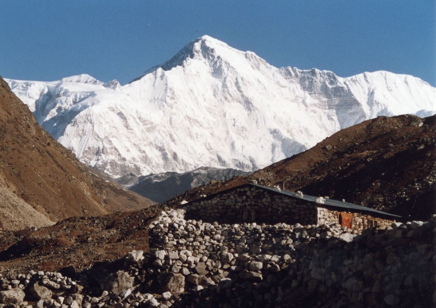 The south side of Cho Oyu from Gokyo. | |
| Highest point | |
| Elevation | 8,188 m (26,864 ft) Ranked 6th |
| Prominence | 2,340 m (7,680 ft)[1] |
| Isolation | 29 km (18 mi) |
| Listing | Eight-thousander Ultra |
| Coordinates | 28°05′39″N 86°39′39″E |
| Naming | |
| English translation | Turquoise Goddess |
| Language of name | Tibetan |
| Geography | |
 Cho Oyu Location in Province No. 1, Nepal and Tibet Autonomous Region, China  Cho Oyu Cho Oyu (Nepal)  Cho Oyu Cho Oyu (Tibet) | |
| Location | Nepal (Province No. 1)–China (Tibet) |
| Parent range | Mahalangur Himal, Himalayas |
| Climbing | |
| First ascent | October 19, 1954 by Herbert Tichy, Joseph Jöchler, Pasang Dawa Lama (First winter ascent 12 February 1985 Maciej Berbeka and Maciej Pawlikowski) |
| Easiest route | snow/ice/glacier climb |
Just a few kilometres west of Cho Oyu is Nangpa La (5,716m/18,753 ft), a glaciated pass that serves as the main trading route between the Tibetans and the Khumbu's Sherpas. This pass separates the Khumbu and Rolwaling Himalayas. Due to its proximity to this pass and the generally moderate slopes of the standard northwest ridge route, Cho Oyu is considered the easiest 8,000 metre peak to climb.[3] It is a popular objective for professionally guided parties.
Height
Cho Oyu's height was originally measured at 26,750 feet (8,150 m) and at the time of the first ascent it was considered the seventh highest mountain on earth, after Dhaulagiri at 8,167 metres (26,795 ft) (Manaslu, now 8,156 metres (26,759 ft), was also estimated lower at 26,658 feet (8,125 m)).[4] A 1984 estimate of 8,201 metres (26,906 ft) made it move up to sixth place. New measurements made in 1996 by the Government of Nepal Survey Department and the Finnish Meteorological Institute in preparation for the Nepal Topographic Maps put the height at 8,188 m,[5] one remarkably similar to the 26,867 feet (8,189 m) used by Edmund Hillary in his 1955 book High Adventure.[6]
Climbing history
Cho Oyu was first attempted in 1952 by an expedition organised and financed by the Joint Himalayan Committee of Great Britain as preparation for an attempt on Mount Everest the following year. The expedition was led by Eric Shipton and included Edmund Hillary, Tom Bourdillon and George Lowe.[7] A foray by Hillary and Lowe was stopped due to technical difficulties and avalanche danger at an ice cliff above 6,650 m (21,820 ft) and a report of Chinese troops a short distance across the border influenced Shipton to retreat from the mountain rather than continue to attempt to summit.[8]
The mountain was first climbed on October 19, 1954, via the north-west ridge by Herbert Tichy, Joseph Jöchler and Sherpa Pasang Dawa Lama of an Austrian expedition.[9] Cho Oyu was the fifth 8000 metre peak to be climbed, after Annapurna in June 1950, Mount Everest in May 1953, Nanga Parbat in July 1953 and K2 in July 1954. Until the ascent of Mount Everest by Reinhold Messner and Peter Habeler in 1978, this was the highest peak climbed without supplemental oxygen.[10]

Cho Oyu is considered the easiest eight-thousander,[nb 1] with the lowest death-summit ratio (1⁄25th of Annapurna's).[12][13] It is the second most climbed eight-thousander after Everest (whose height makes it the most popular), and has over four times the ascents of the third most popular eight-thousander, Gasherbrum II. It is marketed as a "trekking peak", achievable for climbers with high fitness, but low mountaineering experience.[citation needed] It has a broadly flat summit plateau with no cairn (the traditional prayer flags on Cho Oyu's summit plateau do not mark the "technical" summit),[nb 2] which can be a source of confusion, and debate, amongst climbers (see Elizabeth Hawley).[nb 3]
View

Timeline

- 1952 First reconnaissance of north-west face by Edmund Hillary and party.[9]
- 1954 First ascent by Austrians Joseph Jöchler and Herbert Tichy, and Pasang Dawa Lama (Nepal)[9]
- 1958 Second ascent of the peak, by an Indian expedition. Sherpa Pasang Dawa Lama reaches the peak for the second time. First death on Cho Oyu.[9]
- 1959 Four members are killed in an avalanche during a failed international women's expedition.[9]
- 1964 Controversial third ascent by a German expedition as there is no proof of reaching the summit. Two mountaineers die of exhaustion in camp 4 at 7,600 m (24,930 ft).[9]
- 1978 Edi Koblmüller and Alois Furtner of Austria summit via the extremely difficult southeast face.[9]
- 1983 Reinhold Messner succeeds on his fourth attempt,[9] with Hans Kammerlander and Michael Dacher.
- 1984 Věra Komárková (USA) and Dina Štěrbová (Czechoslovakia) become the first women to climb Cho Oyu. Štěrbová is also the first woman from Czechoslovakia to climb an 8000er.
- 1985 On February 12, Poles Maciej Berbeka and Maciej Pawlikowski make the first winter ascent via a new route on the southeast face. It is the only winter ascent on an eight-thousander made on a new route and the first winter ascent without additional oxygen support. The ascent was repeated three days later by Andrzej Heinrich and Jerzy Kukuczka, with Kukuczka setting an additional record for climbing two eight-thousanders during the same winter, as he had earlier climbed Dhaulagiri.
- 1988 On November 2, a Slovenian expedition consisting of Iztok Tomazin, Roman Robas, Blaž Jereb, Rado Nadvešnik, Marko Prezelj, and Jože Rozman, reach the summit via the never before climbed north face.
- 1994 On May 13 Carlos Carsolio sets a world record speed ascent from base camp to summit, ascending in 18 hours and 45 minutes.[16]
- 1994 First solo ascent via the South West face by Yasushi Yamanoi.[17]
- 2000 Russian-Finnish expedition of nine climbers summitted the top, but two of them disappeared in the attempt and presumed dead.[18]
- 2004 Second summit by a double amputee (Mark Inglis)[19]
- 2007 Second Indian ascent. Expedition led by Abhilekh Singh Virdi.[20]
- 2009 Clifton Maloney, husband of US Representative Carolyn Maloney and at that time the oldest American to summit an eight-thousander,[21] died at age 71 after summiting on 25 September. His final words were "I’m the happiest man in the world. I’ve just summited a beautiful mountain."[22]
- 2011 Dutch climber Ronald Naar dies after becoming unwell at 8,000 m (26,250 ft).[23][24]
See also
- 1952 British Cho Oyu expedition
- Nangpa La shooting incident (in 2006)
- Cho Oyu 8201m – Field Recordings from Tibet
Notes
- Of the fourteen mountains surpassing the magic number 8000 metres in height, it is considered the easiest one to climb, and only the highest, Everest, has had more ascents.[11]
- Many people who climb Cho Oyu in Tibet stop at a set of prayer flags with views of Everest and believe they’ve reached the top, unaware they still have to walk for 15 minutes across the summit plateau until they can see the Gokyo Lakes in Nepal.[14]
- Miss Hawley uses the “did you see Everest” as her standard question, I have mentioned this to her as well. I have summitted Cho Oyu 4 times and will be heading for my fifth this coming season. Each time I have watched the Koreans and Japanese go only to where they can see Everest, not the summit, because they know this is what will be asked.[15]
References
- "China I: Tibet - Xizang". Peaklist.org. Retrieved 2014-05-29.
- "NASA Earth Observatory: Cho Oyu". NASA. 2018.
- "Cho Oyu". Peakware.com. Archived from the original on 2016-03-04.
- Tichy, Herbert (1957). Cho Oyu: by favour of the gods. Methuen. p. 195. Retrieved 2016-10-28.
- 2886 15 Pasan Lhamu Chuli map
- Hillary, Edmund (1955). High Adventure. Oxford University Press. p. 49. ISBN 9780195167344.
- Barnett, Shaun (7 December 2010). "Cho Oyu expedition team, 1952". The Dictionary of New Zealand Biography.
- Hillary, pp. 79-80
- Everest News.com. "Cho Oyu History". Retrieved 2008-04-12.
- Günter Seyfferth, Cho Oyu, 8201 m, Erkundung, Erstbesteigung, Erstbegehungen, Ereignisse (in German)
- "Goddess of Turquoise: my attempt on Cho Oyu". Mark Horrell. August 2010.
- "Stairway to heaven". The Economist. 29 May 2013. Retrieved 2015-09-07As of March 2012
{{cite web}}: CS1 maint: postscript (link) - "ALL 8000ers – ASCENTS vs FATALITIES". 8000ers.com. 2008.
- "When is a summit not a summit?". Mark Horrell. 12 November 2014.
- "Cho Oyu summit: Where is it exactly". Explorersweb.com. September 2017.
- "Guest: Carlos Carsolio". Outside Online. 2000. Archived from the original on 13 August 2007. Retrieved 2014-01-15.
- Griffin, Lindsay (11 Oct 2011). "Piolets d'Or Asia honours Urubko". The British Mountaineering Council. Retrieved 2014-01-15.
- Yershov, Andrew (27 May 2000). "Russian-Finnish Expedition Cho-Oyu 2000". Retrieved 2022-05-17.
- "Double amputee scales Mt Everest". BBC News. 16 May 2006. Retrieved 2014-05-17.
- "Timeline Climbing Of Cho Oyu". blogspot.com. June 2011. Retrieved 2014-01-15.
- "Clifton Maloney, 71, died on one of highest peaks". thevillager.com. Archived from the original on 10 October 2016. Retrieved 2017-11-08.
- "Rep. Carolyn Maloney's Husband Dies During Mountain Climb - Gothamist". 2009-10-01. Archived from the original on 2009-10-01. Retrieved 2017-11-08.
- "Dutch Climber Ronald Naar dies on Cho Oyu". The Outside Blog Dispatches. Outside Online. 25 May 2011. Retrieved 2014-01-15.
- "Dutch mountaineer Ronald Naar dies during China climb". DutchNews.nl. 23 May 2011. Retrieved 2014-01-15.
Sources
- Hillary, Edmund (1955). High Adventure. Bloomsbury Publishing. ISBN 0-7475-6696-8. Retrieved 2014-01-15.
- Herbert Tichy, Cho Oyu - Gnade der Götter, (Vienna: Ullstein 1955)
External links
![]() Media related to Cho Oyu at Wikimedia Commons
Media related to Cho Oyu at Wikimedia Commons
- Cho Oyu page on Summitpost.org
- Cho Oyu page on Himalaya-Info.org (German)
- "Cho Oyu". Peakware.com. Archived from the original on 2016-03-04.
- Ascents and fatalities statistics
- Cho Oyu from Kyrgyzstan
- Birdseye view video
Authority control | |
|---|---|
| General |
|
| National libraries | |
На других языках
[de] Cho Oyu
Cho Oyu oder Qowowuyag („Göttin des Türkis“; tibetisch .mw-parser-output .Tibt.uchen{font-family:"Qomolangma-Dunhuang","Qomolangma-Uchen Sarchen","Qomolangma-Uchen Sarchung","Qomolangma-Uchen Suring","Qomolangma-Uchen Sutung","Qomolangma-Title","Qomolangma-Subtitle","Qomolangma-Woodblock","DDC Uchen","DDC Rinzin","Kailash","BabelStone Tibetan","Jomolhari","TCRC Youtso Unicode","Tibetan Machine Uni","Wangdi29","Noto Sans Tibetan","Microsoft Himalaya"}.mw-parser-output .Tibt.ume{font-family:"Qomolangma-Betsu","Qomolangma-Chuyig","Qomolangma-Drutsa","Qomolangma-Edict","Qomolangma-Tsumachu","Qomolangma-Tsuring","Qomolangma-Tsutong","TibetanSambhotaYigchung","TibetanTsugRing","TibetanYigchung"}.mw-parser-output .Tibt{font-size:140%}ཇོ་བོ་དབུ་ཡ Wylie .mw-parser-output .Latn{font-family:"Akzidenz Grotesk","Arial","Avant Garde Gothic","Calibri","Futura","Geneva","Gill Sans","Helvetica","Lucida Grande","Lucida Sans Unicode","Lucida Grande","Stone Sans","Tahoma","Trebuchet","Univers","Verdana"}jo-bo-dbu-ya; chinesisch .mw-parser-output .Hani{font-size:110%}卓奥友山, Pinyin Zhuó'àoyǒu Shān, Nepali .mw-parser-output .Deva{font-size:120%}@media all and (min-width:800px){.mw-parser-output .Deva{font-size:calc(120% - ((100vw - 800px)/80))}}@media all and (min-width:1000px){.mw-parser-output .Deva{font-size:100%}}चो ओयु Cho Oyu) ist ein Achttausender im Himalaya. Er liegt im zentralen Himalaya nur 20 km westlich von Mount Everest und Lhotse und stellt den westlichen Eckpfeiler des Mahalangur Himal im Himalaya-Hauptkamm dar. Die Grenze zwischen China und Nepal verläuft über den Gipfel des Cho Oyu.- [en] Cho Oyu
[es] Cho Oyu
El Cho Oyu (en nepalí: चोयु; tibetano: ཇོ་བོ་དབུ་ཡ, Wylie: jo bo dbu yag, ZYPY: Qowowuyagen: en chino, 卓奧友山; pinyin, Zhuó'àoyǒu Shān) es la sexta montaña más alta de la Tierra, alcanzando los 8.201 m s. n. m.. Cho Oyu significa en tibetano la “Diosa Turquesa”. La montaña es la elevación más alta del macizo Khumbu, sector del Mahalangur Himalaya y está situada aproximadamente a 20 km al oeste del monte Everest. La montaña se encuentra ubicada justo en la frontera entre Nepal y la región autónoma del Tíbet, en China.[fr] Cho Oyu
Le Cho Oyu est un sommet culminant à 8 188 mètres d'altitude, à la frontière entre le Tibet, en Chine, et le Népal, dans l'Himalaya. Il constitue le sixième plus haut sommet au monde. Sa première ascension a été réussie le 19 octobre 1954, un an et demi après celle de l'Everest situé à moins de trente kilomètres, par Herbert Tichy, Josef Jöchler et Pasang Dawa Lama. L'itinéraire qu'ils ont gravi, se terminant sur la face nord-ouest et peu technique, est devenu la voie normale empruntée par la quasi-totalité des alpinistes, malgré une grande diversité de voies ouvertes dans la seconde moitié du XXe siècle. Les versants nord et sud font respectivement partie de la réserve naturelle du Qomolangma et du parc national de Sagarmatha.[it] Cho Oyu
Il Cho Oyu (la Dea Turchese) con i suoi 8.201 m s.l.m., è la sesta montagna più elevata della Terra, situato sul confine tra Cina e Nepal, all'interno della catena dell'Himalaya e distante circa 20 km ad ovest dell'Everest.[ru] Чо-Ойю
Чо-О́йю[2][3][4][5][неавторитетный источник?], Чововуяг[6][7], Чо-Ою́[8][9] (тиб. ཇོ་བོ་དབུ་ཡག, тиб. пиньинь: Qowowuyag; непальск. चोयु, Cho Oyu; кит. трад. 卓奧友峰, упр. 卓奥友峰, пиньинь Zhuó'àoyǒu fēng, палл. Чжоаою фэн) — гора в Гималаях. Высота над уровнем моря — 8201 м, это шестой по высоте восьмитысячник мира.Другой контент может иметь иную лицензию. Перед использованием материалов сайта WikiSort.org внимательно изучите правила лицензирования конкретных элементов наполнения сайта.
WikiSort.org - проект по пересортировке и дополнению контента Википедии