geo.wikisort.org - Mountains
Lhotse (Nepali: ल्होत्से L'hōtsē Nepali pronunciation: [lot.se]; Tibetan: ལྷོ་རྩེ Tibetan pronunciation: [l̥otse], lho tse, Chinese: 洛子峰) is the fourth highest mountain in the world at 8,516 metres (27,940 ft), after Mount Everest, K2, and Kangchenjunga. The main summit is on the border between Tibet Autonomous Region of China and the Khumbu region of Nepal.
| Lhotse | |
|---|---|
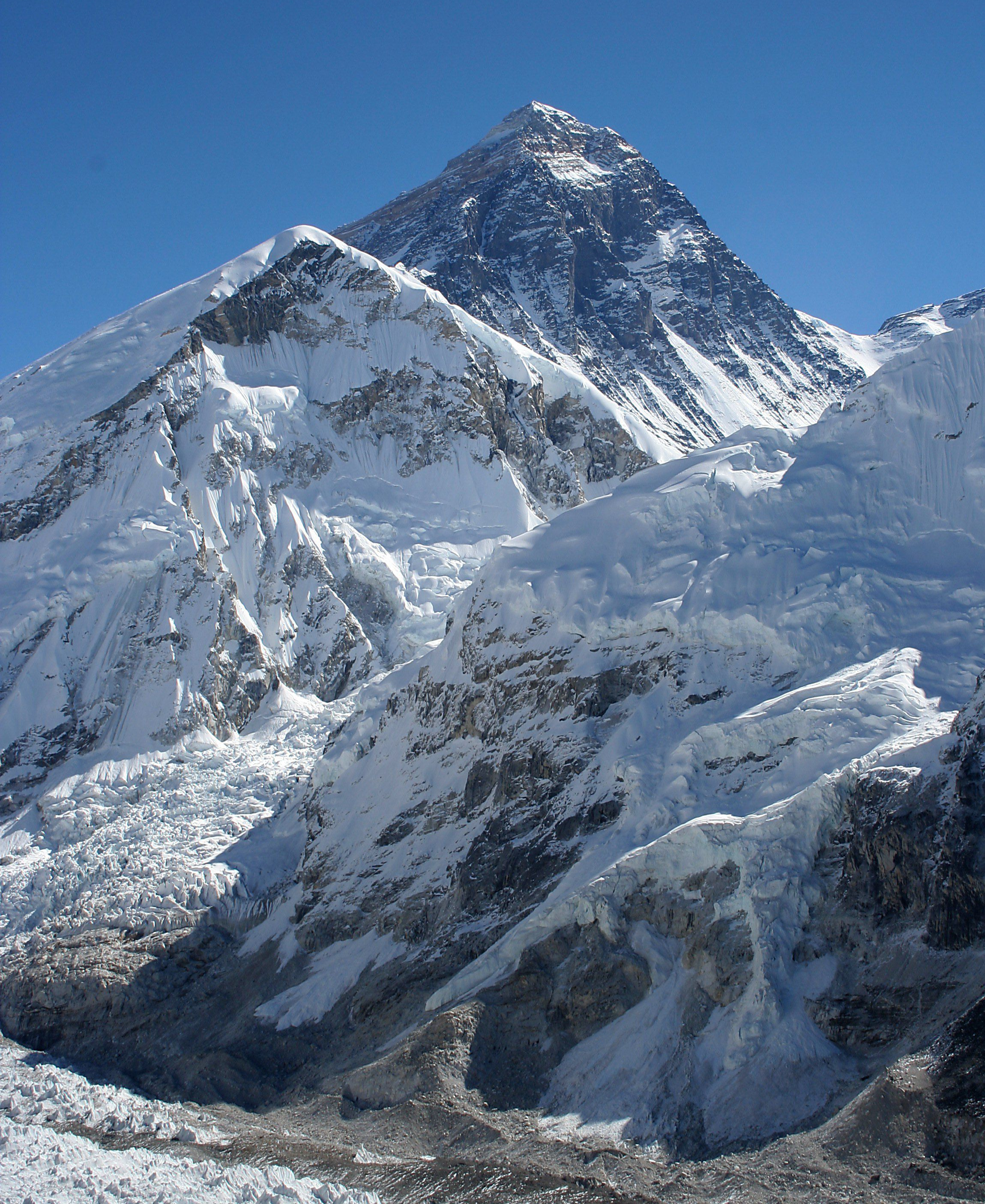
 The South Face of Lhotse as seen from the climb up to Chukhung Ri | |
| Highest point | |
| Elevation | 8,516 m (27,940 ft)[nb 1] Ranked 4th |
| Prominence | 610 m (2,000 ft)[1] |
| Isolation | 2.66 km (1.65 mi) |
| Listing | Eight-thousander |
| Coordinates | 27°57′42″N 86°56′00″E[1] |
| Geography | |
 Lhotse Solukhumbu District, Sagarmatha Zone, Nepal Tingri County, Shigatse Prefecture, Tibet Autonomous Region, China  Lhotse Lhotse (Nepal)  Lhotse Lhotse (Tibet) | |
| Parent range | Mahalangur Himal, Himalayas |
| Climbing | |
| First ascent | 18 May 1956 Fritz Luchsinger, Ernst Reiss (First winter ascent 31 December 1988 Krzysztof Wielicki) |
| Easiest route | glacier/snow/ice climb |
 | |
| Lhotse | |||
|---|---|---|---|
| Traditional Chinese | 洛子峰 | ||
| Simplified Chinese | 洛子峰 | ||
| |||
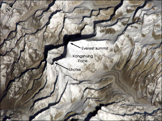
With Everest to the north and Nuptse to the west, Lhotse forms the apex of the massive horseshoe-shaped arc of the Everest massif. Despite the tremendous vertical relief of its South and Northeast Faces, it is the least prominent of the eight-thousanders due to the great height of the South Col between it and Everest. Lhotse’s Western Face, recessed behind the head of the Khumbu Glacier in the Western Cwm, plays an integral part in the standard routes of ascent for both peaks; the name Lhotse, which means "South Peak" in Tibetan, further emphasizes the close relationship between the two.
The main ridge of the mountain features four distinct summits: Lhotse Main at 8,516 metres (27,940 ft) above sea level, Lhotse Middle (also known as Lhotse Central I or Lhotse East) at 8,414 m (27,605 ft), Lhotse Central II at 8,372 m (27,467 ft) and Lhotse Shar at 8,383 m (27,503 ft). Though Lhotse Main is considered to be an intermediately difficult eight-thousander when ascended from the standard Reiss Couloir route, its secondary summits and extremely steep South Face are regarded as some of the most difficult and dangerous climbs in the world.[2][3] Its icy Northeastern Face remains unclimbed.[4]
Climbing
An early attempt on Lhotse was by the 1955 International Himalayan Expedition, headed by Norman Dyhrenfurth. It also included two Austrians (cartographer Erwin Schneider and Ernst Senn) and two Swiss (Bruno Spirig and Arthur Spöhel), and was the first expedition in the Everest area to include Americans (Fred Beckey, George Bell, and Richard McGowan). The Nepalese liaison officer was Gaya Nanda Vaidya. They were accompanied by 200 local porters and several climbing Sherpas. After a brief look at the dangerous southern approaches of Lhotse Shar, they turned their attention, during September and October, to the Western Cwm and the northwest face of Lhotse, on which they achieved an altitude of about 8,100 metres (26,600 ft). They were beaten back by unexpectedly strong wind and low temperatures. Under Schneider's direction, they completed the first map of the Everest area (1:50,000 photogrammetric). The expedition also made several short films covering local cultural topics and made a number of first ascents of smaller peaks in the Khumbu region.[5]
The main summit of Lhotse was first climbed on 18 May 1956, by the Swiss team of Ernst Reiss and Fritz Luchsinger, members of the Swiss Mount Everest/Lhotse Expedition.[6][7]
On 12 May 1970, Sepp Mayerl and Rolf Walter of Austria made the first ascent of Lhotse Shar.[8]
Lhotse Middle remained, for a long time, the highest unclimbed named point on Earth; its first ascent was made on 23 May 2001 by Eugeny Vinogradsky, Sergei Timofeev, Alexei Bolotov and Petr Kuznetsov of a Russian expedition.[9]
The Lhotse standard climbing route follows the same path as Everest's South Col route up to the Yellow Band beyond Camp 3. After the Yellow Band, the routes diverge with climbers bound for Everest taking a left over the Geneva Spur up to the South Col, while Lhotse climbers take a right further up the Lhotse face. The last part to the summit leads through the narrow "Reiss couloir" until the Lhotse main peak is reached.
By December 2008, 371 climbers had summited Lhotse while 20 had died during their attempt.[10] Lhotse was not summited in 2014, 2015, or 2016 due to a series of incidents. It was next summited in May 2017.[11]

Timeline
- 1955 Attempt by the International Himalayan Expedition.[5]
- 1956 May 18 First ascent of the main summit: Fritz Luchsinger and Ernst Reiss.[6]
- 1965 First attempt on Lhotse Shar by a Japanese expedition – reached 8,100 m (26,570 ft).[12]
- 1970 May 12 First ascent of Lhotse Shar by an Austrian expedition, Sepp Mayerl, Rolf Walter.
- 1973 First attempt on the South Face by a Japanese expedition led by Ryohei Uchida.
- 1974 December 25 First attempt of an 8,000-meter peak in winter. Polish climbers Andrzej Zawada and Andrzej Heinrich reached a height of 8,250 meters (27,067 ft.).
- 1975 Attempt on the South Face by Reinhold Messner.[13]
- 1977 Second ascent of the main summit by a German expedition led by Dr. G. Schmatz.
- 1979 Ascent of the main summit by Andrzej Czok and Jerzy Kukuczka without the use of supplemental oxygen[14] (Kukuczka's first conquered eight-thousander, and eventually the last one to climb 10 years later). Ascent was in company of Zygmunt Andrzej Heinrich and Janusz Skorek. 4 days later second group climbed to the peak - Janusz Baranek, Adam Bilczewski, Stanisław Cholewa, Robert Niklas. Leszek Czarnecki, climbed with the group without the use of supplemental oxygen, but carrying the oxygen to elevation of 8350 m, where he was forced to turn back due to inclement weather.
- 1980 April 27 Attempt on Lhotse Shar by the French climber Nicolas Jaeger, last seen at 8,200 metres (26,900 ft).
- 1981 Attempt on the South Face by a Yugoslavian expedition led by Aleš Kunaver. Vanja Matijevec and Franček Knez reach the top of the Face but not the summit.[15]
- 1981 April 30 First solo ascent without the use of supplement oxygen of the main summit by Hristo Prodanov,[16][17] as part of the first Bulgarian Himalayan expedition.
- 1981 October 16 Second ascent of Lhotse Shar, Colin Molines[18]
- 1984 May 20/21 Members of the Czechoslovak expedition led by Ivan Galfy climb the South Face of Lhotse Shar for the first time (third overall ascent of Lhotse Shar).[15][17]
- 1986 October 16 Ascent by Reinhold Messner, thus becoming the first person to climb all of the fourteen eight-thousanders.
- 1987 May 21 the Brazilian Otto William Gerstenberger Junior and the Swiss Haans Singera reach the summit.
- 1988 December 31 Krzysztof Wielicki, a Polish climber, completed the first winter ascent of Lhotse.[19]
- 1989 October 24 Jerzy Kukuczka perishes while climbing the South Face when his secondhand rope breaks.[14] An international expedition led by Reinhold Messner to climb the South Face was unsuccessful.[13]
- 1990 April 24 Tomo Česen from Slovenia, makes a first solo ascent of the South Face of Lhotse.[20][21] Controversy of his climb is later raised by the Soviet Himalayan expedition, claiming that his ascent would be impossible.[22] Reinhold Messner would also raise his doubts.
- 1990 October 16 First ascent of South Face by the Soviet Himalayan expedition members Sergey Bershov and Gennadiy Karataev.
- 1994 May 13 Carlos Carsolio got mountaintop solo, introducing a world speed record at 23 h 50 min rise from Base Camp to the summit.
- 1996 May 10 Chantal Mauduit becomes the first woman to reach the summit of Lhotse.[22]
- 1996 May 17 Anatoli Boukreev solo ascent, world speed record at 21 hours 16 min from Base Camp to summit without supplemental oxygen; he had summited Everest the week before.[23]
- 1997 Attempt to climb Lhotse Middle via the ridge between the main summit and Lhotse Shar by a Russian expedition, led by Vladimir Bashkirov, who died in the attempt, just below the main summit.[24]
- 1999 Attempt to climb Lhotse Middle and traverse the three summits by a Russian team, failed due to bad weather.[17]
- 2001 May 23 First ascent of Lhotse Middle by a Russian expedition.[9][17][25]
- 2007 Pemba Doma Sherpa, Nepali mountaineer and two-time summiter of Mount Everest, falls to her death from Lhotse at 8000 m[26]
- 2011 May 14–15, Michael Horst, American guide, summits Mount Everest and Lhotse without descending below Camp IV (South Col) with less than 21 hours elapsing between the two summits.[27]
- 2011 on 20 May, Indian mountaineer Arjun Vajpai became the youngest climber ever to summit Lhotse, aged 17 years, 11 months and 16 days.[28]
- 2017 on 19 May, Belgian Stef 'Wolf' Wolfsput became the first person with a disability to climb to the summit of Lhotse and only the second Belgian. He suffers a paralysed leg.[citation needed]
- 2018 on 22 May, Mexican climber José Luis Sánchez Fernández became the first Latin American to summit both Mount Everest and Lhotse in less than 24 hours.[29]
- 2018 on 30 September, Hilaree Nelson and Jim Morrison complete the first ski descent from the summit of Lhotse.[30]

Lhotse Face

The western flank of Lhotse is known as the Lhotse Face. Any climber bound for the South Col on Everest must climb this 1,125 m (3,690 ft) wall of glacial blue ice. This face rises at 40 and 50-degree pitches with the occasional 80-degree bulges. High-altitude climbing Sherpas and the lead climbers will set fixed ropes up this wall of ice. Climbers and porters need to establish a good rhythm of foot placement and pulling themselves up the ropes using their jumars. Two rocky sections called the Yellow Band and the Geneva Spur interrupt the icy ascent on the upper part of the face.
On 19 May 2016, a high-altitude mountain worker, Ang Furba Sherpa, died when he slipped and fell down the Lhotse face.[31]

From Gokyo Ri

See also
- Lhotse Shar Glacier
Notes
- A height of 8,501 m is sometimes given but official Nepalese and Chinese mapping agree on 8,516 m.
References
- "General Info". 8000ers.com. Retrieved 20 December 2009.
- "Lhotse FAQ:27,940 feet 8516 meters". Retrieved 14 February 2022.
- "Lhotse Shar 8400 meters 2003 expedition".
- "The Expedition Archives of Elizabeth Hawley".
- Dyhrenfurth, Norman G. (1956). "Lhotse, 1955". American Alpine Journal. 10 (1): 7. Retrieved 10 April 2016.
- "The Swiss Mount Everest/Lhotse Expedition 1956". Swiss Foundation for Alpine Research. Retrieved 14 December 2020.
- Marmet, JÜRG (1957). Translated from German by H. Adams Carter. "Everest — Lhotse, 1956". American Alpine Journal. 10 (2): 121. Retrieved 10 April 2016.
- "Lhotse Shar". old.risk.ru. Retrieved 17 January 2011.
- Koshelenko, Yuri (2002). "Unraveling the Mystery of Lhotse Middle". American Alpine Journal. American Alpine Club. 44 (76): 166. Retrieved 10 April 2016.
- "Lhotse statistics". 8000ers.com. Retrieved 20 December 2009.
- Pokhrel, Rajan (16 May 2017). "Mt Lhotse records first successful ascent after three years". The Himalayan Times. Retrieved 27 April 2019.
- "Asia, Nepal, Lhotse Shar: Climbs and Expeditions". Climbs And Expeditions. American Alpine Journal. American Alpine Club. 17 (2): 434. 1971. Retrieved 8 May 2014.
- "Ascents of Lhotse". peakbagger.com. Retrieved 28 September 2016.
- "Jerzy "Jurek" Kukuczka". everesthistory.com. Retrieved 19 August 2013.
- Morgan, Ed (2016). Lhotse South Face- The Wall of Legends. Bee Different Books. p. 73. ISBN 978-0-9935148-0-7.
- "Christo Prodanov". everesthistory.com. Retrieved 19 August 2013.
- "Lhotse – Historical Timeline". summitpost.org. Retrieved 28 September 2016.
- Sujarwo, Anton (2018). MAHKOTA HIMALAYA: Kecamuk kompetisi para legenda dalam perebutan 14 puncak gunung tersulit di dunia. Anton Sujarwo. p. 222. ISBN 978-602-07-1306-9.
- "Krzysztof Wielicki sounds off on Shisha winter climb!". mounteverest.net. Archived from the original on 12 May 2014. Retrieved 8 May 2014.
- Cesen, Tomo (1991). "South Face of Lhotse, 1990". The Himalayan Journal. 47. Retrieved 8 May 2014.
- Cesen, Tomo (1991). Translated by Maja Košak. "A Look into the Future, Lhotse's South Face". American Alpine Journal. American Alpine Club. 33 (65): 1. Retrieved 10 April 2016.
- Pratt, Jonathan (1998). "Lhotse 96: Controversy in the Shadow of Everest" (PDF). Alpine Journal: 93–96. Retrieved 14 December 2020.
- "Hero of Everest Tragedy Was Climbing Prodigy". adventure-journal.com. September 2016.
- Hawley, Elizabeth (1998). "Lhotse Intermediate, Attempt and Tragedy". American Alpine Journal. American Alpine Club. Retrieved 6 January 2017.
- "Lhotse Middle (8414 m)". russianclimb.com. Retrieved 28 September 2016.
- "Famous female Nepal climber dead". BBC News. 23 May 2007. Retrieved 20 December 2009.
- "Everest and Lhotse in Less Than 21 Hours". Climbing.com. Archived from the original on 20 September 2011. Retrieved 16 October 2011.
- "Young Indian mountaineer scales Mt Lhotse". The Times of India. 20 May 2011. Archived from the original on 5 November 2012. Retrieved 19 August 2013.
- "Mexican climbs the Everest and Lhotse in less than a day". 27 May 2018. Retrieved 27 March 2019.
- Brown, Julie. "How Hilaree Nelson and Jim Morrison Skied Lhotse". Outside Online. Retrieved 14 December 2020.
- "Over 200 summitting Mount Everest today; a Sherpa guide dies". The Himalayan Times. 19 May 2016. Retrieved 14 December 2020.
Further reading
- Reiss, Ernst (1959). Mein Weg als Bergsteiger (in German). Frauenfeld, Huber. OCLC 52217934.
- A. Arnette : Lhotse gaining attention (2014)
- E. Morgan: Lhotse South Face – The Wall of Legends (2016)
External links
- Lhotse page on Himalaya-Info.org (German)
- Lhotse page on Summitpost
- "Lhotse". Peakware.com. Archived from the original on 4 March 2016.
- Lhotse on GeoFinder.ch
| Topography and landmarks |
|  |
|---|---|---|
| Expeditions |
| |
| Notable fatalities |
| |
| Committees |
| |
| In media |
| |
| Years |
| |
| Mount Everest massif | ||
| Records |
| |
| Mountain guides |
| |
Authority control | |
|---|---|
| General |
|
| National libraries | |
На других языках
[de] Lhotse
Der Lhotse (in China offiziell Lhozê; tibetisch .mw-parser-output .Tibt.uchen{font-family:"Qomolangma-Dunhuang","Qomolangma-Uchen Sarchen","Qomolangma-Uchen Sarchung","Qomolangma-Uchen Suring","Qomolangma-Uchen Sutung","Qomolangma-Title","Qomolangma-Subtitle","Qomolangma-Woodblock","DDC Uchen","DDC Rinzin","Kailash","BabelStone Tibetan","Jomolhari","TCRC Youtso Unicode","Tibetan Machine Uni","Wangdi29","Noto Sans Tibetan","Microsoft Himalaya"}.mw-parser-output .Tibt.ume{font-family:"Qomolangma-Betsu","Qomolangma-Chuyig","Qomolangma-Drutsa","Qomolangma-Edict","Qomolangma-Tsumachu","Qomolangma-Tsuring","Qomolangma-Tsutong","TibetanSambhotaYigchung","TibetanTsugRing","TibetanYigchung"}.mw-parser-output .Tibt{font-size:140%}ལྷོ་རྩེ Wylie .mw-parser-output .Latn{font-family:"Akzidenz Grotesk","Arial","Avant Garde Gothic","Calibri","Futura","Geneva","Gill Sans","Helvetica","Lucida Grande","Lucida Sans Unicode","Lucida Grande","Stone Sans","Tahoma","Trebuchet","Univers","Verdana"}lho rtse; chinesisch .mw-parser-output .Hani{font-size:110%}洛子峰, Pinyin Luòzǐ Fēng) ist ein Berg im Himalaya an der Grenze zwischen Nepal und China. Mit einer Höhe von 8516 m ist er der vierthöchste Berg der Erde. Der Lhotse ist ein Nachbarberg des Mount Everest, mit dem er über dessen 7986 m hohen Südsattel verbunden ist. Der tibetische Name Lhotse bedeutet „Südspitze“ und deutet auf die Zugehörigkeit zum Everest-Massiv hin.- [en] Lhotse
[es] Lhotse
El Lhotse (en nepalí: ल्होत्से; en chino, 洛子峰; pinyin, Luòzǐ Fēng) es la cuarta montaña más alta de la Tierra, solo superada por el Everest, el K2 y el Kangchenjunga. Se halla muy cerca del Everest, con el que queda conectado a través del Collado Sur. Lhotse significa literalmente “Pico Sur” en tibetano. Además de la cumbre principal, con una altitud de 8.516 m s. n. m., la montaña cuenta con dos picos subsidiarios, el Lhotse Medio (al este) de 8.414 m y el Lhotse Shar de 8.383 m s. n. m.. La montaña se halla situada en la frontera entre la región sur del Tíbet, en China, y la región de Khumbu, al norte de Nepal.[fr] Lhotse
Le Lhotse est un sommet culminant à 8 516 mètres d'altitude, à la frontière entre la Chine et le Népal, dans l'Himalaya. Il constitue le quatrième plus haut sommet du monde. Sa première ascension a été réussie le 18 mai 1956 par les Suisses Fritz Luchsinger et Ernst Reiss. Leur itinéraire, par le versant nord-ouest, est devenu la voie normale empruntée par la quasi-totalité des alpinistes, les autres voies n'étant pas répétées.[it] Lhotse
Il Lhotse è la quarta montagna più alta della Terra con i suoi 8.516 m s.l.m. È composto da tre vette ed è collegato direttamente all'Everest tramite il Colle Sud (7.906 m).[ru] Лхоцзе
Лхоцзе́[2], Лходзе[3], Лхоце[4] (непальск. ल्होत्से, тиб. ལྷོ་རྩེ, Вайли: lho rtse, тиб. пиньинь: Lhozê, кит. трад. 洛子峰, пиньинь Luòzǐ Fēng) (8516 м) — гора в Гималаях. Четвёртый по высоте восьмитысячник мира. Находится на границе Китая (Тибетский автономный район) и Непала в горном хребте Махалангур-Гимал. Входит в состав национального парка Сагарматха (Непал).Другой контент может иметь иную лицензию. Перед использованием материалов сайта WikiSort.org внимательно изучите правила лицензирования конкретных элементов наполнения сайта.
WikiSort.org - проект по пересортировке и дополнению контента Википедии