geo.wikisort.org - Reservoir
Gorak Shep or Gorakshep (Nepali: गोराशप) is a small settlement that sits on the edge of a frozen lakebed covered with sand in Nepal with the same name. It is found at an elevation of 5,164 metres (16,942 ft) elevation, near Mount Everest. The village is not inhabited year-round.
Gorakshep
Nepali: गोराशप Gorak Shep | |
|---|---|
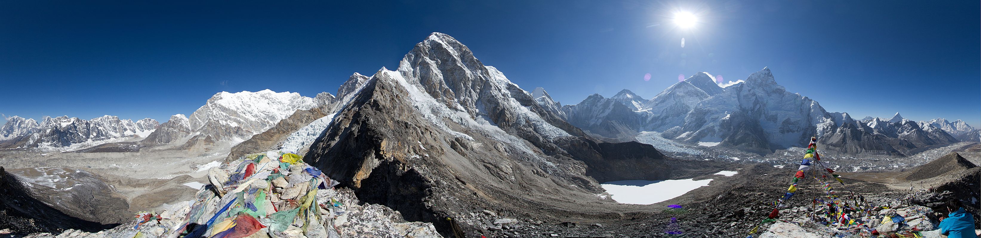
 Everest and Nuptse overlook a Gorak Shep lodge | |
 Gorakshep  Gorakshep | |
| Coordinates: 27°58′50″N 86°49′43″E[1] |
Even though trekking lodges at Gorak Shep are basic, in recent times more modern amenities have become available, such as satellite high-speed internet access.
Trekking
Gorak Shep is inside the Sagarmatha National Park, the homeland of the Sherpa people, famous for their skills as guides and mountaineers. It is the final stop on most common treks to Everest Base Camp from Lukla, following what the Dalai Lama dubbed "the steps to heaven."
This route takes trekkers from Lukla to Namche Bazaar, Tengboche, Pangboche, Dingboche, Lobuche, and on to Gorak Shep. Most trekkers stay overnight there, as their trekking permits will not allow them to camp at Everest Base Camp.[2]
Also, Gorak Shep provides the best "launching pad" for an ascent of Kala Patthar, which looks like a giant dune looming over the lakebed. For many trekkers, summitting Kala Patthar, with its 5,550 meters (18,209 ft), provides both the best views of Everest and the highest altitude that most will reach without a climbing permit, which must be obtained in Kathmandu, at the Nepal Mountaineering Association.[3]
Climbing starts in the early morning, when the visibility is usually better. It takes four hours to summit and come back. Gorak Shep was the original Everest Base Camp, being used by the Swiss mountain climbers in their attempt to climb the Everest in 1952. Later the camp was moved closer to the mountain, just below the Khumbu Ice Fall. Climbing time from Gorak Shep to the Everest Base Camp ranges from 1.5 to 2.5 hours, depending on the weather, acclimatization and physical conditioning of each individual.[4] At this altitude, few people feel comfortable and many start to suffer symptoms of altitude sickness or acute mountain sickness (AMS).[5][6]
Frozen Lake
| Gorakshep | |
|---|---|
 Gorakshep  Gorakshep | |
| Coordinates | 27°59′00″N 86°50′00″E |
| Type | frozen lake |
Climate
The best times for trekking are in spring (March and April) and autumn (October and November), when the visibility of the mountain is ideal and the temperature is not excessively cold.[7] However, in autumn the competition for bed spaces in the lodges can be intense, though normally trekkers are allowed to sleep on the floor of the dining room lodge.[4]
During the winter, in the months from December to February, it is possible to do trekking, but the vast majority of accommodations are closed, the trails are snow-covered and the cold is very intense. Gorak Shep means "dead ravens," because of the complete lack of any kind of vegetation in this place.[4]
 |
 |
 |
See also
- La Rinconada, Peru - the highest elevation year-round human habitation in the world at 5,100 m (16,730 feet).
References
- Gorak Shep Wikimapia
- Junket Nepal
- Climbing Permit
- Bradley, Mayhew; "Trekking in the Nepal Himalaya"; (2009); 9th edition; p 97 (map) and pp 120-122; Lonely Planet; ISBN 978-1-74104-188-0.
- Muza, SR; Fulco, CS; Cymerman, A (2004). "Altitude Acclimatization Guide.". US Army Research Inst. of Environmental Medicine Thermal and Mountain Medicine Division Technical Report (USARIEM-TN-04-05). http://archive.rubicon-foundation.org/7616 Archived 2009-04-23 at the Wayback Machine . Retrieved 2009-03-05
- Windsor, Jeremy (10 May 2019). "Mountain Medicine, Critical Care Fellowships and 'Surviving the Death Zone'". www.ics.ac.uk.
- Shrestha, Vinod Prasad;”Concise Geography of Nepal; 2007; Kathmandu; Mandal Publications;ISBN 978-99946-55-04-5
External links
На других языках
[de] Gorak Shep
Gorak Shep ist die letzte dauerhaft bewohnte Ortschaft (VDC Khumjung) vor dem Südaufstieg zum Mount Everest über das Tal des Schweigens („Western Cwm“).- [en] Gorakshep
[it] Gorak Shep
Gorak Shep o Gorakshep è il letto di un lago ghiacciato coperto di sabbia nel Nepal, nella zona amministrativa di Sagarmatha e anche il nome del piccolo villaggio che si trova sul suo bordo a 5.164 metri di altitudine, posto ai piedi del monte Everest.[1][ru] Горакшеп
Горакшеп (непальск. गोराशप[4]) — озеро, а также небольшая шерпская[1] деревня около него. Расположены на высоте 5164[5] (5207[4][6]) метров над уровнем моря, недалеко от Джомолунгмы[5], в комитете сельского развития[en] Кумджунг-7[7], район Кхумбу (или Солукхумбу[en]), административная зона Сагарматха, Восточный регион развития[en], Непал[4].Другой контент может иметь иную лицензию. Перед использованием материалов сайта WikiSort.org внимательно изучите правила лицензирования конкретных элементов наполнения сайта.
WikiSort.org - проект по пересортировке и дополнению контента Википедии