geo.wikisort.org - Mountains
The South Summit of Mount Everest in the Himalayas is a subsidiary peak to the primary peak of Mount Everest. Although its elevation above sea level of 8,749 metres (28,704 ft) is higher than the second-highest mountain on Earth, K2 (whose summit is 8,611 metres (28,251 ft) above sea level), it is not considered a separate mountain as its prominence is only 11 meters.
| Mount Everest South Summit | |
|---|---|
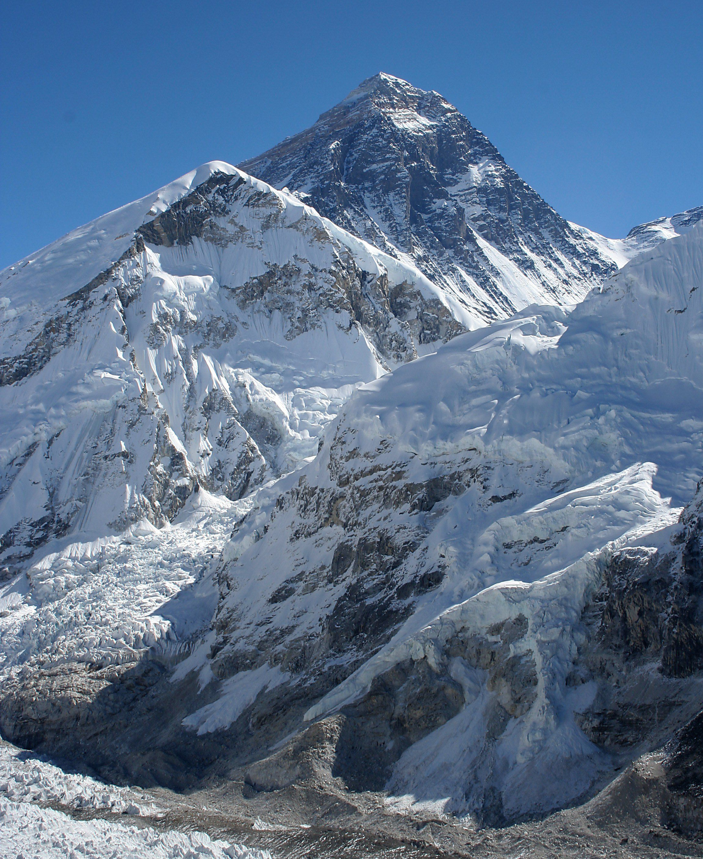
 The south summit is the sub-peak on the right side | |
| Highest point | |
| Elevation | 8,749 m (28,704 ft) |
| Prominence | 11 m (36 ft) |
| Parent peak | Mount Everest |
| Isolation | 0.36 km (0.22 mi) |
| Listing | Eight-thousanders |
| Coordinates | 27°59′6″N 86°55′33″E |
| Geography | |
 Mount Everest South Summit Mount Everest, Solukhumbu District, Sagarmatha Zone, Nepal; Mount Everest, Tingri County, Xigazê, Tibet Autonomous Region, China | |
| Parent range | Mahalangur Himal, Himalayas |
| Climbing | |
| First ascent | May 26, 1953[1][2] |
| Normal route | Traversing the South Col |
Overview
The peak is a dome-shaped peak of snow and ice, and is connected to the summit of Mount Everest by the Cornice Traverse and Hillary Step, approximately 130 metres (430 ft) from the higher peak. It was first climbed by Charles Evans and Tom Bourdillon of the 1953 British Mount Everest expedition on 26 May 1953.[1][2][3] They arrived at 1 pm, too late to continue on to the primary summit, because of problems with Evans' oxygen set. Three days later, on 29 May, Edmund Hillary and Tenzing Norgay passed over the south summit to achieve the main peak.
History
On reaching the South Col in 1953, expedition leader John Hunt was struck by the sight, writing "Above us rose the South Summit of Everest ... an elegant snow spire, breathtakingly close yet nearly 3000 feet above our heads ... none of us had been prepared for any spectacle quite so sharp, quite so beautiful as this. To me it seemed that a new and unsuspected peak of alpine stature stood above the South Col."[4]
A geologist with a 1965 Indian Everest expedition discovered a deposit of fossils of seashells in limestone about 100 feet above the South Summit. This expedition put nine climbers on the main summit. [5]
Describing his first ascent of Mount Everest without supplemental oxygen in 1978, Reinhold Messner described the South Summit as "quite a milestone for me".[6]
During the 1996 Mount Everest disaster, mountain guide Rob Hall and three other people died at the South Summit while descending from the main summit in an unexpected blizzard. Hall survived overnight, and established radio contact the following day, but froze to death later that day, May 11, 1996. His body remains on the South Summit.[7][8]
The south summit is a popular place for climbers to stop for various reasons, and to turn around if necessary.[9] From this location the cornice traverse, Hillary Step, and summit can be seen in clear weather and for modern climbers using bottled oxygen, it is a favored spot to change oxygen bottles.[9]

References
- Isserman, Maurice; Weaver, Stewart (2010). Fallen Giants: A History of Himalayan Mountaineering from the Age of Empire to the Age of Extremes. Yale University Press. pp. 286–287. ISBN 9780300164206.
- Kerr, Jim (2008). Hillary and Norgay's Mount Everest Adventure: Great journeys across earth. Heinemann-Raintree Library. p. 45. ISBN 9781403497550.
- Gill, Michael (2017). Edmund Hillary: A Biography. Nelson, NZ: Potton & Burton. p. 202. ISBN 978-0-947503-38-3.
- Sir John Hunt, The Ascent of Everest, Hodder & Stoughton, 1953, p.176
- Kohli, Mohan Singh (2000). Nine Atop Everest: Spectacular Indian Ascent. New Delhi: Indus Publishing. pp. 168–169. ISBN 9788173871115.
- Messner, Reinhold (1979). Everest: Expedition to the Ultimate. Kaye & Ward. ISBN 9780195201352.
- Boukreev, Anatoli; DeWalt, G. Weston (2015). The Climb: Tragic Ambitions on Everest. St. Martin's Griffin. p. 199. ISBN 9781250099822.
- Simpson, Joe (1999). Dark Shadows Falling. The Mountaineers Books. pp. 33–40. ISBN 9780898865905.
- "NOVA Online | Everest | Climb South | The Way to the Summit". www.pbs.org. Retrieved 2017-06-17.
External links
| Topography and landmarks |
| |
|---|---|---|
| Expeditions |
| |
| Notable fatalities |
| |
| Committees |
| |
| In media |
| |
| Years |
| |
| Mount Everest massif | ||
| Records |
| |
| Mountain guides |
| |
На других языках
- [en] South Summit (Mount Everest)
[it] Cima sud
La Cima sud del monte Everest è la seconda vetta più alta sulla Terra, ed è una vetta sussidiaria di quella primaria del monte Everest. Sebbene la sua altezza sul livello del mare di 8.749 metri sia effettivamente più elevata della seconda montagna più alta sulla Terra, il K2 (la cui cima è 8.611 metri sul livello del mare), essa è considerata solo una vetta separata e non una montagna separata in quanto la sua prominenza (grosso modo, una misura di quanto lontano si proietta sulla linea di contorno adiacente) è di soli 11 metri.Другой контент может иметь иную лицензию. Перед использованием материалов сайта WikiSort.org внимательно изучите правила лицензирования конкретных элементов наполнения сайта.
WikiSort.org - проект по пересортировке и дополнению контента Википедии