geo.wikisort.org - Mountains
Annapurna (/ˌænəˈpʊərnəˌ -ˈpɜːr-/;[1][2] Nepali: अन्नपूर्ण) is a massif in the Himalayas in north-central Nepal that includes one peak over 8,000 metres (26,247 ft), thirteen peaks over 7,000 metres (22,966 ft), and sixteen more over 6,000 metres (19,685 ft).[3] The massif is 55 kilometres (34 mi) long, and is bounded by the Kali Gandaki Gorge on the west, the Marshyangdi River on the north and east, and by Pokhara Valley on the south. At the western end, the massif encloses a high basin called the Annapurna Sanctuary. The highest peak of the massif, Annapurna I Main, is the tenth highest mountain in the world at 8,091 metres (26,545 ft) above sea level. Maurice Herzog led a French expedition to its summit through the north face in 1950, making it the first eight-thousand meter peak ever successfully climbed.[4]
The name for the range comes from the Hindu deity Annapurna meaning the giver of food and nourishment due to the evergreen flowing rivers originating from this mountain range which generates greenery and supports vegetation year round on the lower plains. She is also believed to be one of the daughters of Himavat, the king of the mountains.[5]
The entire massif and surrounding area are protected within the 7,629-square-kilometre (2,946 sq mi) Annapurna Conservation Area, the first and largest conservation area in Nepal. The Annapurna Conservation Area is home to several world-class treks, including Annapurna Sanctuary and Annapurna Circuit.
Historically, the Annapurna peaks have been among the world's most treacherous mountains to climb with the particular case of the extremely steep south face of Annapurna I Main – a wall of rock that rises 3,000 metres (9,800 feet) – making it one of the most difficult climbs in the world.[6] By January 2022, there had been 365 summit ascents of Annapurna I Main, and 72 climbing fatalities for a fatality rate of just under 20 percent.
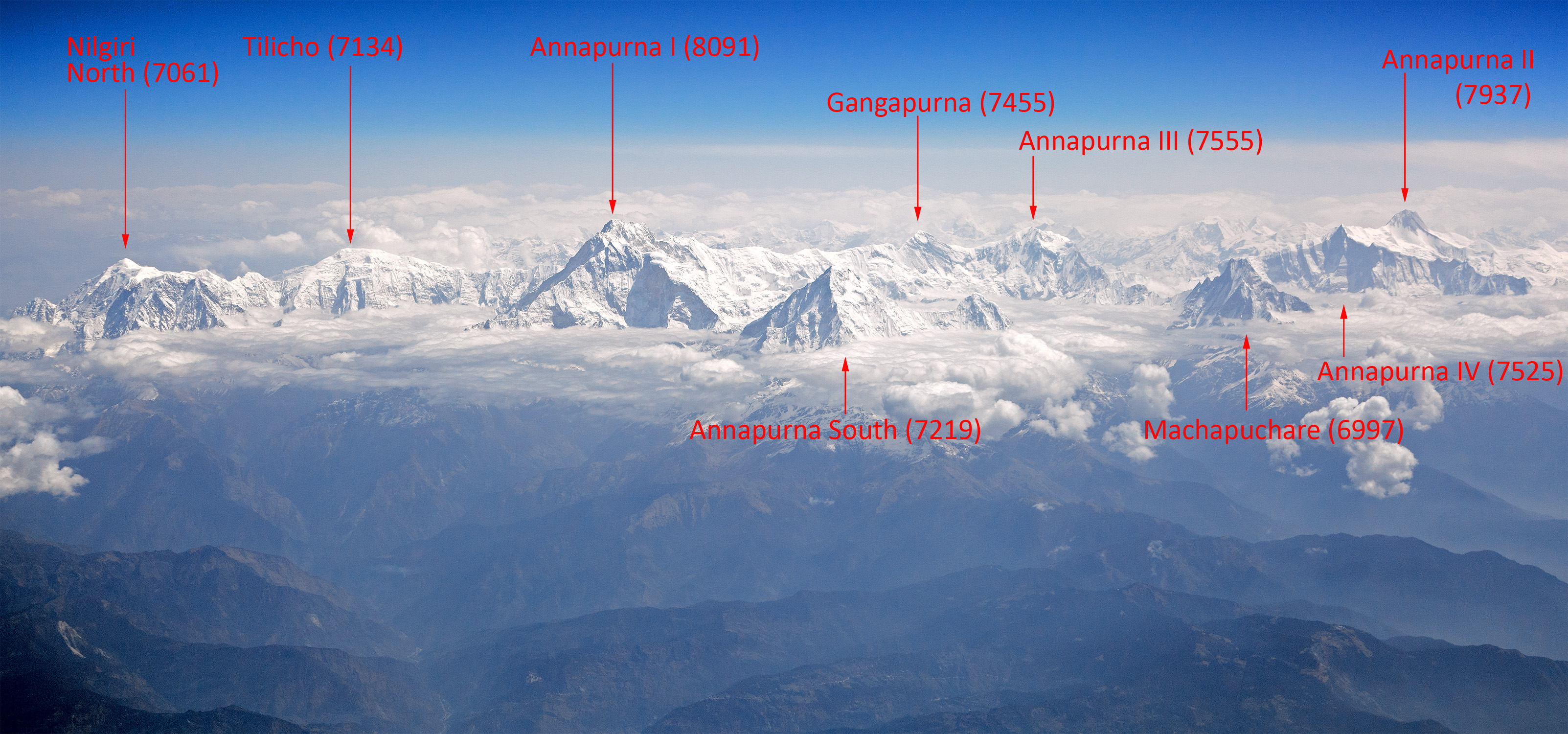
Peaks
The Annapurna massif contains six prominent peaks over 7,200 m (23,620 ft) elevation:
| Mountain | Elevation |
|---|---|
| Annapurna I (Main) | 8,091 m (26,545 ft) |
| Annapurna I Central | 8,051 m (26,414 ft) |
| Annapurna I East | 8,010 m (26,280 ft) |
| Annapurna II | 7,937 m (26,040 ft) |
| Annapurna III | 7,555 m (24,786 ft) |
| Annapurna IV | 7,525 m (24,688 ft) |
| Annapurna South | 7,219 m (23,684 ft) |
| Annapurna Fang | 7,647 m (25,089 ft) |
| Khangsar Kang | 7,485 m (24,557 ft) |
| Tarke Kang | 7,202 m (23,629 ft) |
| Lachenal Peak | 7,140 m (23,425 ft) |
| Tilicho Peak | 7,135 m (23,409 ft) |
| Nilgiri Himal North | 7,061 m (23,166 ft) |
| Nilgiri Himal Central | 6,940 m (22,769 ft) |
| Nilgiri Himal South | 6,839 m (22,438 ft) |
| Machhapuchchhre | 6,993 m (22,943 ft) |
| Hiunchuli | 6,441 m (21,132 ft) |
| Gandharba Chuli | 6,248 m (20,499 ft) |
| Gangapurna | 7,455 m (24,457 ft) |
Climbing history
Gangapurna was first climbed 6 May 1965, by a German expedition led by Günther Hauser, via the East Ridge. The summit party comprised 11 members of the expedition.
Annapurna South (also known as Annapurna Dakshin, or Moditse) was first climbed in 1964 by a Japanese expedition, via the North Ridge. The summit party comprised S. Uyeo and Mingma Tsering.
Hiunchuli (6,441 m/21,126 ft) is a satellite peak extending east from Annapurna South, Hiunchuli was first climbed in 1971 by an expedition led by U.S. Peace Corps Volunteer Craig Anderson.
Mount Machhapuchchhre (6,993 m or 22,943 ft), named after its resemblance to a fish-tail, is another important peak, though it just misses the 7,000 metre mark. Mount Machhapuchchhre and Hiunchuli are prominently visible from the valley of Pokhara. These peaks are the "gates" to the Annapurna Sanctuary leading to the south face of Annapurna I. Mount Machhapuchchhre was climbed in 1957 (except the final 50 metres for its local religious sanctity) by Wilfrid Noyce and A. D. M. Cox. Since then it has been off limits.
Trekking
The Annapurna Conservation Area (7,629 km2) is a well known trekking region. There are three major trekking routes in the Annapurna region: the Jomson Trek to Jomsom and Muktinath (increasingly disturbed by a road-building project[7]); the Annapurna Sanctuary route to Annapurna base camp; and the Annapurna Circuit, which circles the Annapurna Himal itself and includes the Jomsom route.[8] The town of Pokhara usually serves as a starting point for these treks, and is also a good starting place for other short treks of one to four days, such as routes to Ghorepani or Ghandruk.
The Mustang district, a former kingdom bordering Tibet, is also geographically a part of the Annapurna region, but treks to upper Mustang are subject to special restrictions. Mustang is also increasingly becoming popular for mountain biking because of the construction of roads undertaken by the Nepali government in the region.
About two-thirds of all trekkers in Nepal visit the Annapurna region. The area is easily accessible, guest houses in the hills are plentiful, and treks here offer incredibly diverse scenery, with both high mountains and lowland villages. Also, because the entire area is inhabited, trekking in the region offers unique cultural exposure and experience.[9][10] Trekkers are required to purchase a special permit for trekking from the Nepal Immigration Office, with the permit generally being valid for ten days.[11]
2014 trekking disaster
In October 2014, at least 43 people were killed, and some 175 injured, as a result of snowstorms and avalanches on and around Annapurna, including trekkers from Nepal, Israel, Canada, India, Slovakia and Poland. Between 10 and 50 people were thought likely to be missing.[12][13] It was believed that about 100 trekkers had left a guest house at 4,800 metres (15,700 ft), to climb to the top of Thorong La pass and then descend.[13]
The authorities were criticized for not giving sufficient warning of the approaching bad weather.[13] By 18 October, some 289 people were reported as having been rescued. An official from the Nepal Ministry of Tourism said on 18 October that helicopters were looking for survivors and bodies in snowy areas at up to 5,790 metres (19,000 ft), and were trying to reach 22 hikers stranded at Thorong La. The incident was said to be Nepal's worst-ever trekking disaster.[14]
See also
References
- "Annapurna". Dictionary.com Unabridged (Online). n.d. Retrieved 12 June 2019.
- "Annapurna". Lexico UK English Dictionary. Oxford University Press. Archived from the original on 15 April 2021.
- H. Adams Carter (1985). "Classification of the Himalaya" (PDF). American Alpine Journal. 27 (59): 127–9. Retrieved 1 May 2011.
- "The Eight-Thousanders".
- "An Indian mystic, seeking his goddess, goes the hard way in the Himalayas - AP Worldstream | HighBeam Research". 24 September 2015. Archived from the original on 24 September 2015. Retrieved 12 April 2022.
- "Complete ascent — fatalities statistics of all 14 main 8000ers". 8000ers.com. 19 June 2008. Retrieved 30 May 2013.
- Stacy Tasman (27 May 2011). "Nepal's shrinking Annapurna Circuit".
- "Austin Pick: Circling the Abode of Snow". Archived from the original on 21 November 2008. Retrieved 27 December 2008.
- "How to Hike the Annapurna Circuit". 13 June 2013. Archived from the original on 26 August 2016. Retrieved 23 August 2016.
- "Annapurna Circuit Trek". Retrieved 23 August 2016.
- "Permit fees of Nepal". Retrieved 16 May 2019.
- "Nepal trekking disaster: Britons still 'missing' after severe snow storm". The Telegraph. 19 October 2014.
- "Nepal blizzard: survivor tells of friends' deaths on Annapurna circuit". The Guardian. 16 October 2014.
- "Nepal Annapurna: Climbing disaster toll reaches 39". BBC News. 18 October 2014.
Authority control | |
|---|---|
| General | |
| National libraries | |
На других языках
[de] Annapurna Himal
Das Annapurna Himal ist eine bis zu 8091 m hohe nepalische Gebirgsgruppe im Himalaya.- [en] Annapurna (mountain range)
[es] Annapurna
Annapurna (en nepalí, अन्नपूर्णा) es un macizo montañoso situado en el centro de la cordillera del Himalaya que culmina en Annapurna I, con 8091 m. s. n. m. de altitud, siendo la décima montaña más alta de la Tierra y, posiblemente, la más difícil de escalar junto con el K2 y el Nanga Parbat.[fr] Annapurna
L'Annapurna est un massif de montagnes de l'Himalaya au Népal, comprenant six principaux sommets dont le plus haut, l'Annapurna I, culmine à 8 091 mètres, ce qui en fait le dixième plus haut sommet du monde.[it] Annapurna
L'Annapurna[1] (AFI: /annaˈpurna/[2]; nome femminile[1]; in hindi Annapūrṇa) è un massiccio montuoso himalayano situato in Nepal centrale, comprendente l'Annapurna I, la cima più alta che raggiunge gli 8.091 m s.l.m., il decimo monte più alto della Terra, e altre cime comprese all'interno del cosiddetto Santuario dell'Annapurna, noto anche per il famoso percorso escursionistico dell'Annapurna Circuit.[ru] Аннапурна
Аннапу́рна (непальск. अन्नपूर्णा) — горный массив в Гималаях. Высочайшая точка массива — Аннапурна I (8091 м) — является десятым по высоте из четырнадцати восьмитысячников мира.Другой контент может иметь иную лицензию. Перед использованием материалов сайта WikiSort.org внимательно изучите правила лицензирования конкретных элементов наполнения сайта.
WikiSort.org - проект по пересортировке и дополнению контента Википедии