geo.wikisort.org - Sea
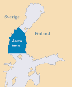
The Bothnian Sea (Swedish: Bottenhavet; Finnish: Selkämeri) links the Bothnian Bay (also called the Bay of Bothnia) with the Baltic proper. Kvarken is situated between the two. Together, the Bothnian Sea and Bay make up a larger geographical entity, the Gulf of Bothnia, where the Bothnian Sea is the southern part.[1] The whole Gulf of Bothnia is situated between Sweden, to the West, Finland, to the East, and the Sea of Åland and Archipelago Sea to the South. The surface area of Bothnian Sea is approximately 79,000 km². The largest coastal towns, from south to north, are Rauma and Pori in Finland, and Gävle and Sundsvall in Sweden. Umeå (Sweden) and Vaasa (Finland) lie in the extreme north, near Bothnian Bay.

See also
- Bothnian Sea National Park
References
- "Bottenhavet" (in Swedish). Nationalencyklopedin. Retrieved 30 January 2016.
External links
 Media related to Bothnian Sea at Wikimedia Commons
Marginal seas of the Atlantic Ocean | |
|---|---|
| Basins |
|
| Bays |
|
| Channels | |
| Gulfs | |
| Seas |
|
На других языках
- [en] Bothnian Sea
[es] Mar de Botnia
El mar de Botnia (en finés: Selkämeri, en sueco: Bottenhavet) es un mar marginal o bahía interior del mar Báltico, la parte más meridional del amplio golfo de Botnia, localizado entre la costa oriental de Suecia y la costa occidental de Finlandia. Se sitúa en el interior del golfo de Botnia, al norte del mar de Åland y al sur del estrecho de Kvarken, que lo conecta con la bahía de Botnia, la parte más septentrional del golfo.Текст в блоке "Читать" взят с сайта "Википедия" и доступен по лицензии Creative Commons Attribution-ShareAlike; в отдельных случаях могут действовать дополнительные условия.
Другой контент может иметь иную лицензию. Перед использованием материалов сайта WikiSort.org внимательно изучите правила лицензирования конкретных элементов наполнения сайта.
Другой контент может иметь иную лицензию. Перед использованием материалов сайта WikiSort.org внимательно изучите правила лицензирования конкретных элементов наполнения сайта.
2019-2026
WikiSort.org - проект по пересортировке и дополнению контента Википедии
WikiSort.org - проект по пересортировке и дополнению контента Википедии