geo.wikisort.org - Sea
The Sea of Crete (Greek: Κρητικό Πέλαγος, Kritiko Pelagos), or Cretan Sea, is a sea, part of the Aegean Sea, located in its southern extremity, with a total surface area of 45,000 km2 (17,000 sq mi). The sea stretches to the north of the island of Crete, east of the islands of Kythera and Antikythera, south of the Cyclades, and west of the Dodecanese islands of Rhodes, Karpathos and Kassos. The bounding sea to the west is the Ionian Sea. To the northwest is the Myrtoan Sea, a subdivision of the Mediterranean Sea that lies between the Cyclades and Peloponnese. To the east-southeast is the rest of the Mediterranean Sea, sometimes credited as the Levantine Sea. Across the island of Crete, to the opposite shore of it begins the Libyan Sea. Ferry routes to and from Piraeus and Heraklion, as well as the southern islands of the Aegean and the Dodecanese, run in this area.
This article needs additional citations for verification. (July 2011) |
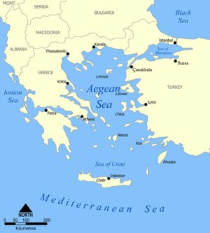
Just off the coastline of Northeastern Crete, the sea reaches a maximum depth of near 3,293 m (10,000 ft).[citation needed] Other sources (maps) show a maximum depth of 2,591 m (8,500 ft).
Port towns and cities
- Kastelli-Kissamos, southwest
- Chania, southwest
- Souda, south-southwest
- Rethymno, south
- Heraklio, south
- Agios Nikolaos, southeast
- Sitia, southeast
- Kassos (Fry), southeast
- Anafi, northeast
- Thira, north
Bays
- Chania Bay, south
- Souda Bay, southeast
- Almyros Bay, south
- Mirabello Bay, southeast
References
- Saundry, Peter; Hogan, C. Michael; Baum, Steve (2011). "Sea of Crete". In Pidwirny, M.; Cleveland, C. J. (eds.). Encyclopedia of Earth. Washington DC: National Council for Science and Environment.
| Authority control |
|
|---|
На других языках
- [en] Sea of Crete
[es] Mar de Creta
El mar de Creta (en griego moderno: Κρητικό Πέλαγος, Kritiko Pelago) es la parte meridional del mar Egeo, uno de los mares litorales del mar Mediterráneo. Sus límites son:[ru] Критское море
Кри́тское мо́ре (греч. Κρητικό Πέλαγος) — южная глубоководная часть Эгейского моря[1].Другой контент может иметь иную лицензию. Перед использованием материалов сайта WikiSort.org внимательно изучите правила лицензирования конкретных элементов наполнения сайта.
WikiSort.org - проект по пересортировке и дополнению контента Википедии