geo.wikisort.org - Sea
The Camotes Sea is a small sea within the Philippine archipelago, situated between the Central Visayan and the Eastern Visayan regions. It separates Cebu from Leyte hence is bordered by Cebu to the west, Leyte to the east and north, and Bohol to the south. At its center are the Camotes Islands, but it also contains Mactan Island, Olango Island, Lapinig Island (in Bohol), and various other small islets.
| Camotes Sea | |
|---|---|
 An outrigger on the sea near Olango Island | |
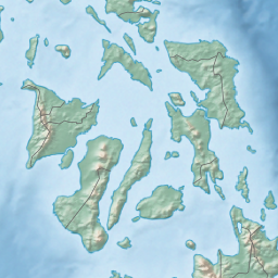 Camotes Sea Location within the Philippines  Camotes Sea Camotes Sea (Philippines) | |
| Location | Visayas |
| Coordinates | 10°30′0″N 124°20′0″E |
| Type | sea |
| Basin countries | Philippines |
| Settlements | |
Northwards, the sea is connected to the Visayan Sea. Southwards, it is connected to the Bohol Sea (also called the Mindanao Sea) in two ways: to the SW by the Cebu Strait (and its 3 channels, the Mactan, the Olango, & the Hilutangan), and to the SE by the Canigao Channel.
The Camotes Sea also contains the Danajon Bank, which is a double barrier reef in the Philippines, which is a very rare geological formation, and there are only 6 double barrier reefs in the world. It comprises two sets of large coral reefs that formed offshore on a submarine ridge due to a combination of favorable tidal currents and coral growth in the area.
See also
- Geography of the Visayas — the central island group of the Philippines.
- Cebu Strait — the strait between the islands of Cebu and Bohol, which connects the Camotes Sea to the Bohol Sea (west part).
- Canigao Channel — the strait between the islands of Bohol and Leyte, which connects the Camotes Sea to the Bohol Sea (east part).
- Danajon Bank — the only double barrier reef of the Philippines.
- Silot Bay — bay in Liloan, Cebu connected to the sea.
Seas of the Philippines | ||
|---|---|---|
| Ocean |
|  |
| Sea | ||
| Strait |
| |
| Gulf | ||
See also: Bodies of water of the Philippines | ||
References
На других языках
- [en] Camotes Sea
[es] Mar de Camotes
El mar de Camotes (en inglés, Camotes Sea) es uno de los mares interiores del archipiélago filipino, un pequeño mar que generalmente se considera parte del mar de Filipinas (y a su vez parte del océano Pacífico), ubicado en el grupo de las islas Bisayas.[ru] Камотес
Камотес (тагальск. и англ. Camotes) — межостровное море в Филиппинском архипелаге, между островами Лейте, Бохол и Себу. На севере соединяется с морем Висаян, на юге проливами Канигао и Бохол — с морем Минданао.Другой контент может иметь иную лицензию. Перед использованием материалов сайта WikiSort.org внимательно изучите правила лицензирования конкретных элементов наполнения сайта.
WikiSort.org - проект по пересортировке и дополнению контента Википедии