geo.wikisort.org - Sea
Panay Gulf is an extension of the Sulu Sea, reaching between the islands of Panay and Negros in the Philippines. The gulf contains the island-province of Guimaras and extends into the Iloilo Strait, between Panay and Guimaras, and into Guimaras Strait, between Guimaras and Negros. Guimaras Strait connects Panay Gulf with the Visayan Sea.
| Panay Gulf | |
|---|---|
 Guimaras' small islands in the Panay Gulf | |
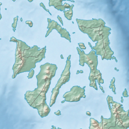 Panay Gulf Location within the Philippines  Panay Gulf Panay Gulf (Philippines) | |
| Location |
|
| Coordinates | 10°15′00″N 122°14′55″E |
| Type | gulf |
| Etymology | Panay |
| Part of | Sulu Sea |
| Settlements | |
The Port of Iloilo is the busiest port on the gulf, which is a major route used by ships plying the areas between Iloilo City, Bacolod, and Zamboanga further to the south.[1]
The Panay Landing during World War II occurred from the Panay Gulf.[2]
References
- Menon, Ajay (2021-06-14). "10 Major Ports In The Philippines". Marine Insight. Retrieved 2022-08-10.
- Gomez, Sheila Mae (2021-03-01). "Liberation of Panay Day: Battle of the Visayas in World War II". IBS Digital Network. Retrieved 2022-08-10.
Seas of the Philippines | ||
|---|---|---|
| Ocean |
|  |
| Sea | ||
| Strait |
| |
| Gulf | ||
See also: Bodies of water of the Philippines | ||
This article about a location in the Philippines is a stub. You can help Wikipedia by expanding it. |
Текст в блоке "Читать" взят с сайта "Википедия" и доступен по лицензии Creative Commons Attribution-ShareAlike; в отдельных случаях могут действовать дополнительные условия.
Другой контент может иметь иную лицензию. Перед использованием материалов сайта WikiSort.org внимательно изучите правила лицензирования конкретных элементов наполнения сайта.
Другой контент может иметь иную лицензию. Перед использованием материалов сайта WikiSort.org внимательно изучите правила лицензирования конкретных элементов наполнения сайта.
2019-2026
WikiSort.org - проект по пересортировке и дополнению контента Википедии
WikiSort.org - проект по пересортировке и дополнению контента Википедии