geo.wikisort.org - Sea
The Java Sea (Indonesian: Laut Jawa, Javanese: Segara Jawa) is an extensive shallow sea on the Sunda Shelf, between the Indonesian islands of Borneo to the north, Java to the south, Sumatra to the west, and Sulawesi to the east. Karimata Strait to its northwest links it to the South China Sea. It is a part of the western Pacific Ocean.[1][2]
| Java Sea | |
|---|---|
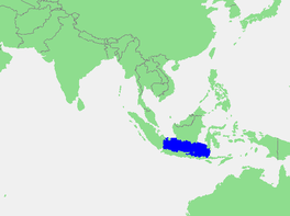 Location of the Java Sea | |
 Java Sea | |
| Location | Sunda Shelf |
| Coordinates | 5°S 110°E |
| Type | Sea |
| Primary inflows | Barito, Bengawan Solo, Brantas, Ciliwung, Cimanuk, Citarum, Kahayan, Musi, Sampit River |
| Basin countries | Indonesia |
| Max. length | 1,600 km (990 mi) |
| Max. width | 380 km (240 mi) |
| Surface area | 320,000 km2 (120,000 sq mi) |
| Average depth | 46 m (151 ft) |
| Settlements | Batulicin, Cirebon, Jakarta, Jepara, Makassar, Pekalongan, Probolinggo, Semarang, Surabaya, Tanjung Pandan, Tegal, Toboali, Tuban |
Geography
The Java Sea covers the southern section of the 1,790,000 km2 (690,000 sq mi) Sunda Shelf. A shallow sea, it has a mean depth of 46 m (151 ft). It measures about 1,600 km (990 mi) east-west by 380 km (240 mi) north-south[3] and occupies a total surface area of 320,000 km2 (120,000 sq mi).
It formed as sea levels rose at the end of the last ice age.[4] Its almost uniformly flat bottom, and the presence of drainage channels (traceable to the mouths of island rivers), indicate that the Sunda Shelf was once a stable, dry, low-relief land area (peneplain) above which were left standing a few monadnocks (granite hills that, due to their resistance to erosion, form the present islands).
Extent
The International Hydrographic Organization (IHO) defines the Java Sea as one of the waters of the East Indian Archipelago, with the following criteria:[5]
On the North. By the Southern limit of the South China Sea [Lucipara Point (3°14′S 106°05′E) thence to Tanjong Nanka, the Southwest extremity of Bangka Island, through this island to Tanjong Berikat the Eastern point (2°34′S 106°51′E), on to Tanjong Djemang (2°36′S 107°37′E) in Billiton, along the North coast of this island to Tanjong Boeroeng Mandi (2°46′S 108°16′E) and thence a line to Tanjong Sambar (3°00′S 110°19′E) the Southwest extreme of Borneo], the South coast of Borneo and the Southern limit of Makassar Strait [By a line from the Southwestern extreme of Celebes (5°37′S 119°27′E), through the Southern point of Tana Keke, to the Southern extreme of Laoet (4°06′S 116°06′E) thence up the West coast of that island to Tanjong Kiwi and thence across to Tanjong Petang, Borneo (3°37′S 115°57′E) at the Southern end of Laoet Strait].
On the East. By the Western limit of Flores Sea [A line from Tg Sarokaja (8°22′S 117°10′E) to the Western Paternoster island (7°26′S 117°08′E) thence to the Northeastern Postiljon Island (6°33′S 118°49′E) and to the West point of Laikang Bay, Celebes].
On the South. By the Northern and Northwestern limits of Bali Sea [A line from the Western Paternoster Island to the East point of Sepandjang and thence through this island to the West point of Gedeh Bay on the South coast of Kangean (7°01′S 115°18′E). A line from the West point of Gedeh Bay, Kangean Island, to Tg Sedano, the Northeast extreme of Java and down the East coast to Tg Bantenan, the Southeast extreme of the island], the North and West coasts of Java to Java Hoofd (6°46′S 105°12′E) its Western point, and thence a line to Vlakke Hoek (5°55′S 104°35′E) the Southern extreme of Sumatra.
On the West. The East coast of Sumatra between Vlakke Hoek and Lucipara Point (3°14′S 106°05′E).
History

The Battle of the Java Sea from February to March 1942, was one of the costliest naval battles of World War II. The naval forces of the Netherlands, Britain, Australia, and the United States were nearly destroyed trying to defend Java from Japanese attack.[6][7]
On 28 December 2014, Indonesia AirAsia Flight 8501 crashed into the Java Sea while on route to Singapore from Surabaya, East Java. All 162 passengers and crew were killed.[8]
On 29 October 2018, Lion Air Flight 610 crashed into the Java Sea shortly after takeoff from Soekarno–Hatta International Airport in Jakarta heading towards Depati Amir Airport in Pangkal Pinang. All 189 passengers and crew on board are presumed dead.[9]
On 9 January 2021, a Boeing 737-500 (PK-CLC) operating as Sriwijaya Air Flight 182, crashed, near Laki Island, shortly after taking off from Soekarno–Hatta International Airport, en route to Supadio International Airport, with 50 passengers and 12 crew members aboard.[10]
Economic activities
The southern section of the seafloor has long been recognized as geologically similar to northern Java, where oil fields occur and extend under the sea. Prospects are also favourable for oil fields in the waters off southeast Kalimantan. As the site of successful exploration for petroleum and natural gas, the Java Sea has become the basis of Indonesia's export program.
Fishing is an important economic activity in the Java Sea. Over 3,000 species of marine life are found in the area. A number of national parks exist in the area such as Karimunjawa. The Thousand Islands are located north of the national capital Jakarta, and are the city's only regency.
The area around the Java Sea is also a popular tourist destination. Scuba diving offers a chance to explore and photograph underwater caverns, wrecks, coral, sponges, and other marine life.[11]
References
- AirAsia flight QZ8501: 5 things about Java Sea, where search for plane is taking place. The Straits Times. December 28, 2014
- Java Sea. Encyclopædia Britannica.
- GoogleEarth
- "Pleistocene Sea Level Maps". The Field Museum. 2003.
- "Limits of Oceans and Seas, 3rd edition" (PDF). International Hydrographic Organization. 1953. Archived from the original (PDF) on 8 October 2011. Retrieved 28 December 2020.
- Oosten, F. C. van The Battle of the Java Sea Publisher: London : I. Allen, 1976. ISBN 0-7110-0615-6
- Thomas, David A. Battle of the Java Sea. London: Pan Books, 1971. ISBN 0-330-02608-9
- AirAsia flight: teams retrieve bodies from Java Sea. The Guardian. Dec 30, 2014.
- Noyes, James Massola, Jenny (29 October 2018). "Lion Air flight crashes in Indonesia". The Sydney Morning Herald. Retrieved 29 October 2018.
- "Dozens feared dead after Boeing 737 drops 10,000ft into sea off Indonesia". Independent.co.uk. 10 January 2021.
- Epton, Nina. The Islands of Indonesia. London, Pitman 1955
Further reading
- Touwen, Jeroen (editor) (2001) Shipping and trade in the Java Sea region, 1870-1940 : a collection of statistics on the major Java Sea ports ISBN 90-6718-162-5
- (2008) "Java Sea a study on its economic impacts."
Indonesian seas | |
|---|---|
| Ocean |
|
| Sea | |
| Strait |
|
| Gulf | |
Authority control | |
|---|---|
| General |
|
| National libraries | |
На других языках
- [en] Java Sea
[es] Mar de Java
El mar de Java (en indonesio, Laut Jawa) es un mar perimetral del océano Índico, localizado justo en el límite sur del océano Pacífico. Se formó a finales de la última Edad de Hielo[1] y tiene cerca de 310.000 km². Se sitúa en medio de las islas indonesias de Borneo al norte, Java al sur, Sumatra al oeste y Célebes al este.[ru] Яванское море
Ява́нское мо́ре (индон. Laut Jawa, яв. Segara Jawa) — межостровное море Тихого океана, расположенное между островами Калимантан, Сулавеси, Суматра и Ява. Площадь моря — 552 000 км², средняя глубина — 111 м, наибольшая — 1272 м, объём воды — 61 000 км³[1][2].Другой контент может иметь иную лицензию. Перед использованием материалов сайта WikiSort.org внимательно изучите правила лицензирования конкретных элементов наполнения сайта.
WikiSort.org - проект по пересортировке и дополнению контента Википедии