geo.wikisort.org - Sea
Saleh Bay (Indonesian: Teluk Saleh) is the largest bay in the island of Sumbawa, Indonesia, roughly on the north central part. It is semi enclosed by Moyo Island and the peninsula of Tambora, Sanggar Peninsula. 3 larger islands in the bay are Liang Island, Ngali Island, and Rakit Island. 3 of the 4 regencies of Sumbawa border the bay.
| Saleh Bay | |
|---|---|
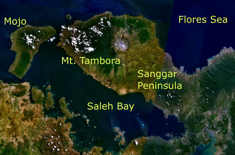 Saleh Bay in the center of the island of Sumbawa. | |
 Saleh Bay | |
| Location | South Asia |
| Coordinates | 8°34′00″S 117°57′00″E |
| Type | Bay |
| Native name | Teluk Saleh (Indonesian) |
| Basin countries | Indonesia |
| References | Teluk Saleh: Indonesia National Geospatial-Intelligence Agency, Bethesda, MD, USA |
Further reading
- Egon T. Degens and Beate Buch (1989) Sedimentological events in Saleh Bay, off Mount Tambora Netherlands Journal of Sea Research (December 1989), 24 (4), pg. 399-404
Indonesian seas | |
|---|---|
| Ocean |
|
| Sea | |
| Strait |
|
| Gulf | |
This East Nusa Tenggara location article is a stub. You can help Wikipedia by expanding it. |
Текст в блоке "Читать" взят с сайта "Википедия" и доступен по лицензии Creative Commons Attribution-ShareAlike; в отдельных случаях могут действовать дополнительные условия.
Другой контент может иметь иную лицензию. Перед использованием материалов сайта WikiSort.org внимательно изучите правила лицензирования конкретных элементов наполнения сайта.
Другой контент может иметь иную лицензию. Перед использованием материалов сайта WikiSort.org внимательно изучите правила лицензирования конкретных элементов наполнения сайта.
2019-2026
WikiSort.org - проект по пересортировке и дополнению контента Википедии
WikiSort.org - проект по пересортировке и дополнению контента Википедии