geo.wikisort.org - Sea
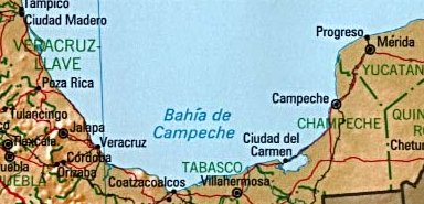
The Bay of Campeche (Spanish: Bahía de Campeche), or Campeche Sound, is a bight in the southern area of the Gulf of Mexico, forming the north side of the Isthmus of Tehuantepec. It is surrounded on three sides by the Mexican states of Campeche, Tabasco and Veracruz. The area of the bay is 6,000 square miles (16,000 km2) and maximum depth of the bay is approximately 180 feet (55 m). It was named by Francisco Hernández de Córdoba and Antón de Alaminos during their expedition in 1517.
This article needs additional citations for verification. (October 2019) |
| Bay of Campeche | |
|---|---|
| |
 Bay of Campeche | |
 Bay of Campeche Bay of Campeche | |
| Location | |
| Coordinates | 20°00′00″N 94°00′00″W |
| Part of |
|
| Ocean/sea sources | Gulf of Mexico |
| Basin countries | Mexico |
| Max. length | 152 nautical miles (175 mi; 282 km) |
| Max. width | 378 nautical miles (435 mi; 700 km) |
| Surface area | 41,909 square nautical miles (55,500 sq mi; 143,740 km2) |
| Islands |
|
Oil resources
The Cantarell Complex of five oil fields lies beneath the Bay of Campeche. In 2003, it was the second most productive oil field in the world, then supplying about two thirds of Mexico's crude oil output, but it went into a steep decline soon thereafter.
On June 3, 1979, Ixtoc I, an exploratory oil well located in the bay, suffered a blowout that caused a catastrophic explosion, resulting in what has been ranked as the third largest unintentional oil spill in history.
Climate
During the months of June and July, the Bay of Campeche is considered one of the "hot" breeding spots for Atlantic hurricanes.
It experiences strong winds from the north from November into February along its western edge, with the winds ultimately funneling between the mountains and out into the Pacific near Salina Cruz.[5]
On the other hand, the bay is also known for being a hurricane "graveyard", with unusually weak steering currents in the area causing hurricanes to slow down and meander, starving themselves (for example, Hurricane Roxanne in 1995). The bay is also considered the eastern border on the main migration routes for birds in the Americas.
Bay of Campeche Pictorials


References
- Triángulo Sur in Geonames.org (cc-by)
- Triángulo Oeste in Geonames.org (cc-by)
- Triángulo Este in Geonames.org (cc-by)
- Cayos Arcas in Geonames.org (cc-by)
- "Salina Cruz Climate, Weather By Month, Average Temperature (Mexico) - Weather Spark". weatherspark.com. Retrieved 2022-10-09.
Notes
- ^ Hauptmann, David. "Where do hurricanes form and where do they strike?". Archived from the original on 2005-11-20. Retrieved 2006-03-27.
- ^ "Routes of Migration". Migration of Birds. Northern Prairie Wildlife Research Center. Archived from the original on 17 April 2006. Retrieved 2006-03-27.
External links
 Media related to Bay of Campeche at Wikimedia Commons
- "General Facts about the Gulf of Mexico" (PDF). U.S. Fish & Wildlife Service. GulfBase.org.
Campeche (capital) | ||
| Municipalities (municipal seats) |
|  |
Marginal seas of the Atlantic Ocean | |
|---|---|
| Basins |
|
| Bays |
|
| Channels | |
| Gulfs | |
| Seas |
|
Authority control | |
|---|---|
| General |
|
| Other | |
This Mexico location article is a stub. You can help Wikipedia by expanding it. |
На других языках
- [en] Bay of Campeche
[ru] Кампече (залив)
Кампе́че (исп. Golfo de Campeche) — залив у восточного берега Центральной Америки, южная часть Мексиканского залива. На востоке омывает берег полуострова Юкатан, на юге — перешеек Теуантепек, а с запада — Веракрус. Название получил в 1517 году в ходе экспедиции Франсиско Эрнандеса де Кордобы.Другой контент может иметь иную лицензию. Перед использованием материалов сайта WikiSort.org внимательно изучите правила лицензирования конкретных элементов наполнения сайта.
WikiSort.org - проект по пересортировке и дополнению контента Википедии