geo.wikisort.org - River
The Gulf of St. Lawrence (French: golfe du Saint-Laurent) is the outlet of the North American Great Lakes via the St. Lawrence River into the Atlantic Ocean. The gulf is a semi-enclosed sea, covering an area of about 226,000 square kilometres (87,000 sq mi) and containing about 34,500 cubic kilometres (8,300 cu mi) of water, at an average depth of 152 metres (500 ft).[1]
This article needs additional citations for verification. (August 2010) |
| Gulf of St. Lawrence | |
|---|---|
| French: Golfe du Saint-Laurent | |
 Gulf of St. Lawrence from Anticosti National Park, Quebec | |
 Bathymetry of the Gulf of St. Lawrence | |
| Coordinates | 48°36′N 61°24′W |
| Type | Gulf |
| Basin countries | Canada Saint Pierre and Miquelon (France) |
| Surface area | 226,000 km2 (87,000 sq mi)[1] |
| Average depth | 152 m (499 ft)[1] |
| Water volume | 34,500 km3 (8,300 cu mi)[1] |
Geography

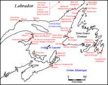
The Gulf of St. Lawrence is bounded on the north by the Labrador Peninsula and Quebec, to the east by Saint-Pierre and Newfoundland, to the south by the Nova Scotia peninsula and Cape Breton Island, and to the west by the Gaspé Peninsula, New Brunswick, and Quebec. As for significant islands the Gulf of Saint Lawrence contains Anticosti Island, Prince Edward Island, Îles-de-la-Madeleine, Cape Breton Island, Saint Pierre Island, and Miquelon-Langlade.
Half of the ten provinces of Canada adjoin the Gulf: New Brunswick, Nova Scotia, Prince Edward Island, Newfoundland and Labrador, and Quebec.
Besides the Saint Lawrence River itself, significant streams emptying into the Gulf of Saint Lawrence include the Miramichi River, Natashquan River, Romaine River, Restigouche River, Margaree River, and Humber River.
Branches of the Gulf include the Chaleur Bay, Fortune Bay, Miramichi Bay, St. George's Bay, Bay St. George, Bay of Islands, and Northumberland Strait.
Outlets
The gulf flows into the Atlantic Ocean through the following outlets:
- The Strait of Belle Isle between Labrador and Newfoundland: between 15 kilometres (9.3 miles) and 60 kilometres (37 miles) wide and 60 metres (200 feet) deep at its deepest.
- The Cabot Strait between Newfoundland and Cape Breton Island: 104 km (65 mi) wide and 480 m (1,575 ft) deep at its deepest.
The Strait of Canso between Cape Breton Island and the Nova Scotia peninsula had been an outlet 1.0 km (0.6 mi) wide and 60 m (200 ft) deep at its deepest. Due to the construction of the Canso Causeway across the strait in 1955, it no longer permits exchange of water between the Gulf of Saint Lawrence and the Atlantic Ocean.
Extent
The limits of the Gulf of Saint Lawrence vary between sources.
The International Hydrographic Organization defines the limits of the Gulf of Saint Lawrence as follows:[2]
On the Northeast.
A line running from Cape Bauld (North point of Kirpon Island, 51°40′N 55°25′W) to the East extreme of Belle Isle and on to the Northeast Ledge (52°02′N 55°15′W). Thence a line joining this ledge with the East extreme of Cape St. Charles (52°13'N) in Labrador.
On the Southeast.
A line from Cape Canso (45°20′N 61°0′W) to Red Point (45°35′N 60°45′W) in Cape Breton Island, through this Island to Cape Breton [45°57′N 59°47′W] and on to Pointe Blanche (46°45′N 56°11′W) in the Island of St. Pierre, and thence to the Southwest point of Morgan Island (46°51′N 55°49′W).
On the West.
The meridian of 64°30'W from Pointe-Jaune (49°04′N 64°30′W) to Magpie (50°19′N 64°30′W), but the whole of Anticosti Island is included in the Gulf.
Fisheries and Oceans Canada places the western limit at Pointe-des-Monts, approximately 138 km (85.8 mi) west of the 64°30'W meridian.[3]
Protected areas and national parks
St. Paul Island in Nova Scotia off the northeastern tip of Cape Breton Island, is known as the "Graveyard of the Gulf" because of its many shipwrecks. Access to this island is controlled by the Canadian Coast Guard.[citation needed]
In 1919 the first Migratory Bird Sanctuaries (MBS) in Canada were established under the Migratory Birds Convention Act on Bonaventure Island, on the Bird Rocks of the Magdalen Islands, and on the Percé Rock. These migratory bird sanctuaries are administered by the Canadian Wildlife Service.[4]
The Federal Government of Canada manages the National Parks of Canada along the Gulf of Saint Lawrence at Forillon National Park on the eastern tip of the Gaspé Peninsula, Prince Edward Island National Park on the northern shore of the island, Kouchibouguac National Park on the northeastern coast of New Brunswick, Cape Breton Highlands National Park on the northern tip of Cape Breton Island, Gros Morne National Park on the west coast of Newfoundland, and a National Park Reserve in the Mingan Archipelago on the Côte-Nord of Quebec.[citation needed]
The five provinces bordering the Gulf of Saint Lawrence have several provincial parks with protected coasts.[citation needed]
Undersea features
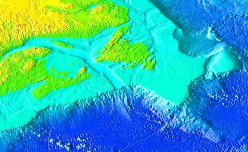
The Laurentian Channel is a feature of the floor of the Gulf that was formed during previous ice ages, when the Continental Shelf was eroded by the Saint Lawrence River during the periods when the sea level plunged. The Laurentian Channel is about 290 m (950 ft) deep and about 1,250 km (780 mi) long from the Continental Shelf to the mouth of the Saint Lawrence River. Deep waters with temperatures between 2 and 6.5 °C (36 and 44 °F) enter the Gulf at the continental slope and are slowly advected up the channel by estuariane circulation.[5] Over the 20th century, the bottom waters of the end of the channel (i.e. in the Saint Lawrence estuary) have become hypoxic.[6]
History
The gulf has provided a historically important marine fishery for various First Nations that have lived on its shores for millennia and used its waters for transportation.[citation needed]
The first documented voyage by a European in its waters was by the French explorer Jacques Cartier in the year 1534. Cartier named the shores of the Saint Lawrence River "The Country of Canadas", after an indigenous word meaning "village" or "settlement", thus naming the world's second largest country.[7]
Basque whalers from Saint-Jean-de-Luz sailed into the Gulf of Saint Lawrence in 1530 and began whaling at Red Bay.[8] They established their base on the Strait of Belle Isle and worked closely with the Iroquois in the Gulf of Saint Lawrence. In 1579 the English government closed all English ports to Spanish oil imports. As a result, a third of Basque whale oil could not be sold. Basque whaling collapsed in the Gulf of Saint Lawrence and never recovered.
See also
References
- "Atlantic region, Government of Canada, page 86" (PDF). publications.gc.ca. Retrieved 14 March 2018.
- "Limits of Oceans and Seas, 3rd edition" (PDF). International Hydrographic Organization. 1953. Archived from the original (PDF) on 8 October 2011. Retrieved 28 December 2020.
- "Fisheries and Oceans Canada - Quebec Region - Estuary and Gulf of St. Lawrence". www.qc.dfo-mpo.gc.ca. Retrieved 14 March 2018.
- "Migratory bird sanctuaries across Canada". Government of Canada. 22 February 2011.
- Galbraith, P.S., Pettipas, R.G., Chassé, J., Gilbert, D., Larouche, P., Pettigrew, B., Gosselin, A., Devine, L. and Lafleur, C. 2009. Physical Oceanographic Conditions in the Gulf of St. Lawrence in 2008. DFO Can. Sci. Advis. Sec. Res. Doc. 2009/014. iv + 69 p.
- Gilbert, D., B. Sundby, C. Gobeil, A. Mucci and G.-H. Tremblay. 2005. A seventy-two-year record of diminishing deep-water oxygen in the St. Lawrence estuary: The northwest Atlantic connection. Limnol. Oceanogr., 50(5): 1654–1666.
- "French navigator Jacques Cartier sails the St. Lawrence River". A&E Television Networks. Retrieved 14 June 2021.
- "Red Bay National Historic Site". 9 February 2022.
External links
- St. Lawrence Global Observatory
- The Gulf of St. Lawrence - A Unique Ecosystem, Department of Fisheries and Oceans
- Timing and position of late Wisconsinan ice-margins on the upper slope seaward of Laurentian Channel
Marginal seas of the Atlantic Ocean | |
|---|---|
| Basins |
|
| Bays |
|
| Channels | |
| Gulfs | |
| Seas |
|
Authority control | |
|---|---|
| General | |
| National libraries | |
| Other |
|
На других языках
- [en] Gulf of St. Lawrence
[ru] Залив Святого Лаврентия
Зали́в Свято́го Лавре́нтия (фр. Golfe du Saint-Laurent; англ. Gulf of Saint Lawrence) — самый крупный на Земле эстуарий, место впадения реки Святого Лаврентия в Атлантический океан на восточном берегу Северной Америки.Другой контент может иметь иную лицензию. Перед использованием материалов сайта WikiSort.org внимательно изучите правила лицензирования конкретных элементов наполнения сайта.
WikiSort.org - проект по пересортировке и дополнению контента Википедии