geo.wikisort.org - Sea
The Thracian Sea (Greek: Θρακικό Πέλαγος, Thrakiko Pelagos; Turkish: Trakya Denizi) is the northernmost part of the Aegean Sea. It is bounded by Macedonia and Thrace as well as northwestern Turkey. The entire area of the sea lies north of the 40th parallel. Its length from east to west is from 23°E to about 25.8°E, or from the Strymonian Gulf east to the northernmost part of the Gallipoli peninsula and the width from north to south is about 40.25°N to 41°N, or from the Dardanelles north to the boundary between the Xanthi and the Rhodope regional units. Islands includes Thasos and Samothrace in Greece and Gökçeada (Imvros in Greek) in Turkey. In the south, the sea extends to the north coast of the island of Lemnos. The bays and gulfs includes the Ierissian Gulf to the southwest, the Strymonian Gulf where the Strymon River empties, the Kavala Gulf and the Saros Gulf in Turkey. Rivers emptying into this portion of the gulf include the Nestos and the Evros/Meriç. The famous thermal springs are Loutra Eleftheron in Kavala.[citation needed]
This article does not cite any sources. (May 2022) |

Ports
- Amfipoli
- Kavala
- Alexandroupoli
- Thasos
- Samothrace
Gallery
 Map of the Aegean Sea. The Thracian Sea can be seen at the top
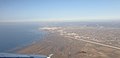 Alexandroupolis, Greece
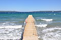 Gallipoli, Turkey
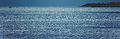 Thracian Sea
 Samothraki island from Dikella beach


Earth's oceans and seas | |
|---|---|
| Arctic Ocean | |
| Atlantic Ocean |
|
| Indian Ocean | |
| Pacific Ocean |
|
| Southern Ocean | |
| Endorheic basins | |
| Others |
|
| |
Marginal seas of the Atlantic Ocean | |
|---|---|
| Basins |
|
| Bays |
|
| Channels | |
| Gulfs | |
| Seas |
|
[[image:]]
References
Authority control | |
|---|---|
| General |
|
| National libraries | |
На других языках
- [en] Thracian Sea
[es] Mar de Tracia
El mar de Tracia (en griego, Θρακικό Πέλαγος, Thrakikó Pélagos; en turco, Trakya Denizi) es un mar epicontinental localizado en la parte septentrional del mar Egeo, que baña las costas griegas de las regiones históricas de Macedonia y Tracia, y la parte nororiental de Turquía. De oeste a este, se extiende desde la península del Monte Athos, en la península Calcídica, hasta la península de Galípoli en los Dardanelos. Se acostumbra a citar el paralelo 40°N como el límite meridional, con las islas de Lemnos y Ténedos (Bozcaada). Además, incluye las islas de Tasos, Samotracia e Imbros (Gökçeada).[ru] Фракийское море
Фракийское море (греч. Θρακικό πέλαγος; др.-греч. Θρηίκιον πέλαγος[1], лат. Macedonicum mare, Thracium mare[2], тур. Trakya Denizi) — античное название северной части Эгейского моря вдоль побережья Фракии[3], между полуостровом Халкидики и Галлипольским полуостровом. С юга ограничено островом Лемносом.Другой контент может иметь иную лицензию. Перед использованием материалов сайта WikiSort.org внимательно изучите правила лицензирования конкретных элементов наполнения сайта.
WikiSort.org - проект по пересортировке и дополнению контента Википедии