geo.wikisort.org - Island
Samothrace (also known as Samothraki, Greek: Σαμοθράκη, [samoˈθraci]) is a Greek island in the northern Aegean Sea. It is a municipality within the Evros regional unit of Thrace. The island is 17 km (11 mi) long and is 178 km2 (69 sq mi) in size and has a population of 2,859 (2011 census). Its main industries are fishing and tourism. Resources on the island include granite and basalt. Samothrace is one of the most rugged Greek islands, with Mt. Saos and its highest peak Fengari rising to 1,611 m (5,285 ft). The Winged Victory of Samothrace, which is now displayed at the Louvre in Paris, originates from the island.
Samothrace
Σαμοθράκη | |
|---|---|
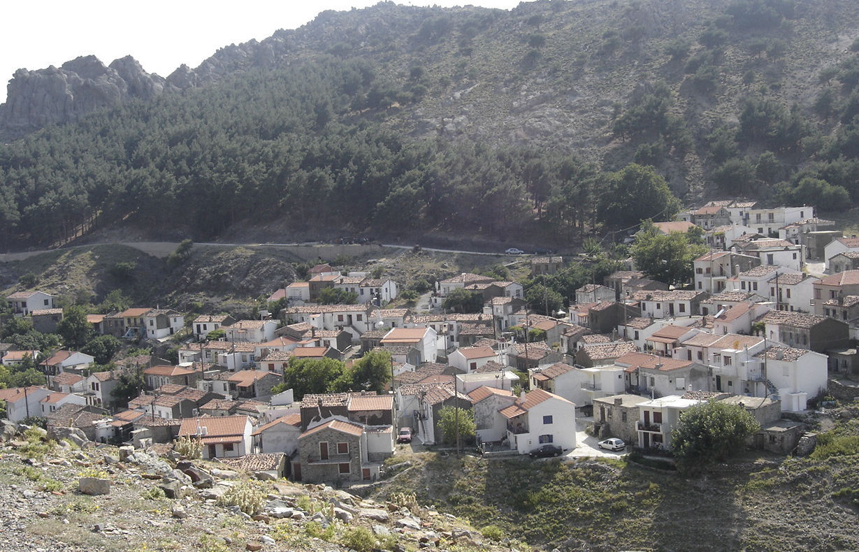
 View of the Chora (Samothraki) | |
 Samothrace Location within the region 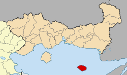 | |
| Coordinates: 40°29′N 25°31′E | |
| Country | Greece |
| Administrative region | East Macedonia and Thrace |
| Regional unit | Evros |
| Government | |
| • Mayor | Vitsas Athanasios[1] (since September 1, 2014[1]) |
| Area | |
| • Municipality | 178.0 km2 (68.7 sq mi) |
| Highest elevation | 1,611 m (5,285 ft) |
| Lowest elevation | 0 m (0 ft) |
| Population (2011)[2] | |
| • Municipality | 2,859 |
| • Municipality density | 16/km2 (42/sq mi) |
| Time zone | UTC+2 (EET) |
| • Summer (DST) | UTC+3 (EEST) |
| Postal code | 680 02 |
| Area code(s) | 25510 |
| Vehicle registration | ΕΒ |
| Website | www.samothraki.gr |

History
Antiquity

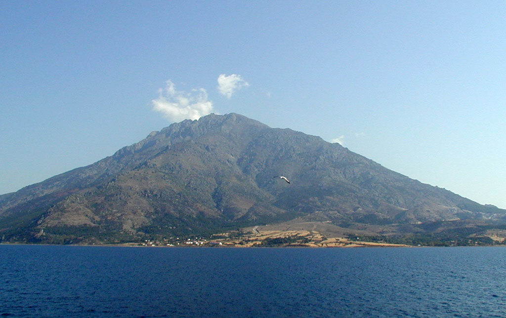


Samothrace was not a state of any political significance in ancient Greece, since it has no natural harbour and most of the island is too mountainous for cultivation: Mount Fengari (literally 'Mt. Moon') rises to 1,611 m (5,285 ft). It was, however, the home of the Sanctuary of the Great Gods, site of important Hellenic and pre-Hellenic religious ceremonies. Among those who visited this shrine to be initiated into the island cult were Lysander of Sparta, Philip II of Macedon and Lucius Calpurnius Piso Caesoninus, father-in-law of Julius Caesar.
The ancient city, the ruins of which are called Palaeopolis ("old city"), was situated on the north coast. Considerable remains still exist of the ancient walls, which were built in massive Cyclopean style, as well as of the Sanctuary of the Great Gods, where mysterious rites (Samothracian Mysteries)[3] took place which were open to both slaves and free people (similar to the Eleusinian Mysteries). Demetrios of Skepsis mentions the Samothracian Mysteries;[3] as does Aristophanes in his Peace.[4]
The traditional account from antiquity is that Samothrace was first inhabited by Pelasgians and Carians, and later Thracians. At the end of the 8th century BC the island was colonised by Greeks from Samos, from which the name Samos of Thrace, that later became Samothrace; however, Strabo denies this. The archaeological evidence suggests that Greek settlement was in the sixth century BC.
The Persians occupied Samothrace in 508 BC, it later passed under Athenian control, and was a member of the Delian League in the 5th century BC. It was subjugated by Philip II, and from then till 168 BC it was under Macedonian suzerainty. With the battle of Pydna Samothrace became independent, a condition that ended when Vespasian absorbed the island in the Roman Empire in AD 70.
The island is mentioned in the King James Version of the Bible, with the name Samothracia.
During the Roman and particularly the imperial period, thanks to the interest of the Roman emperors, the radiation of the sanctuary of the Great Gods surpassed Greek borders and Samothrace became an international religious center, where pilgrims flocked from all over the Roman world. Apart from the famous sanctuary, also playing a decisive role in the great development of Samothrace were her two ports, situated on the sea road Troas – Macedonia. Furthermore, an important role was played by her possessions in Perea, which were conceded by the Romans at least during the imperial period, as evidenced by inscriptions of the 1st AD century.[5]
The Book of Acts in the Christian Bible records that the Apostle Paul, on his second missionary journey outside of Palestine, sailed from Troas to Samothrace and spent one night there on his way to Macedonia.[6]
Middle Ages to Modern era

St. Theophanes died in Samothrace in 818. The Byzantines ruled until 1204, when Venetians took their place, only to be dislodged by a Genoese family in 1355, the Gattilusi. The Ottoman Empire conquered it in 1457 and it was called Semadirek in Turkish; an insurrection against them by the local population during the Greek War of Independence (1821–1831) led to the massacre of 1,000 inhabitants.[7] The island came under Greek rule in 1913 following the Balkan Wars. It was occupied temporarily by Bulgaria during the Second World War, from 1941 to 1944.
Today
The modern port town of Kamariotissa is on the north-west coast and provides ferry access to and from points in northern Greece such as Alexandroupoli and Kavala. There is no commercial airport on the island. Other sites of interest on the island include the ruins of Genoese forts, the picturesque Chora (literally village) and Paleapolis (literally Old Town), and several waterfalls.
A 2019 article estimated that the current population of goats on the island outnumbers humans by about 15 to 1, resulting in unwanted erosion as a result of overgrazing.[8]
Landmarks
The island's most famous site is the Sanctuary of the Great Gods (Greek: Hieron ton Megalon Theon). The most famous artifact from the temple complex is the 2.5-metre marble statue of Nike (now known as the Winged Victory of Samothrace), which dates from about 190 BC. It was discovered in pieces on the island in 1863 by the French archaeologist Charles Champoiseau. It is now headless and is displayed at the Louvre in Paris. The Winged Victory is featured on the island's municipal seal.
Communities
- Alonia (pop. 291 in 2011)
- Ano Karyotes (22)
- Ano Meria (57)
- Dafnes (16)
- Kamariotissa (1,069)
- Kato Karyotes (41)
- Katsampas (15)
- Lakkoma (317)
- Makrylies (12)
- Palaiopoli (36)
- Potamia (6)
- Profitis Ilias (189)
- Samothrace/Samothraki (Chora) (653)
- Therma (106)
- Xiropotamos (29)
Province
The province of Samothrace (Greek: Επαρχία Σαμοθράκης) was one of the provinces of the Evros Prefecture. It had the same territory as the present municipality.[9] It was abolished in 2006.
Climate
Samothraki has a hot-summer Mediterranean climate. Winters are cool and rainy with occasional heavy snowstorms, especially at higher elevations.
| Climate data for Kamariotissa village (90m) | |||||||||||||
|---|---|---|---|---|---|---|---|---|---|---|---|---|---|
| Month | Jan | Feb | Mar | Apr | May | Jun | Jul | Aug | Sep | Oct | Nov | Dec | Year |
| Average high °C (°F) | 11.5 (52.7) |
12.7 (54.9) |
14.5 (58.1) |
17.2 (63.0) |
23.7 (74.7) |
28.7 (83.7) |
31.9 (89.4) |
32.3 (90.1) |
27.6 (81.7) |
22.2 (72.0) |
17.8 (64.0) |
13.9 (57.0) |
21.2 (70.1) |
| Average low °C (°F) | 6.8 (44.2) |
7.1 (44.8) |
8.6 (47.5) |
10.5 (50.9) |
15.8 (60.4) |
20.5 (68.9) |
23.4 (74.1) |
23.9 (75.0) |
20.4 (68.7) |
15.8 (60.4) |
12.7 (54.9) |
9.4 (48.9) |
14.6 (58.2) |
| Average precipitation mm (inches) | 110.1 (4.33) |
55.1 (2.17) |
73.7 (2.90) |
34.7 (1.37) |
29.7 (1.17) |
15.9 (0.63) |
12.2 (0.48) |
9 (0.4) |
8.4 (0.33) |
74.3 (2.93) |
108.3 (4.26) |
101.7 (4.00) |
633.1 (24.97) |
| Source: http://penteli.meteo.gr/stations/samothraki/ (2019-2021 averages) | |||||||||||||
Historical population
| Year | Island population |
|---|---|
| 1981 | 2,871 |
| 1991 | 3,083 |
| 2001 | 2,723 |
| 2011 | 2,859 |
People
- Aristarchus of Samothrace (c. 220 – c. 143 BC), ancient Greek grammarian and Homeric scholar
- Theophanes the Confessor (c. 758 – c. 818)
- Nikolaos Fardys (1853–1901), Greek scholar
Gallery
 Fonias waterfall
 Flowing river on the slopes of Mount Fengari
 Mount Fengari (Saos)
 The Winged Victory of Samothrace, one of the best-known ancient Greek statues (Louvre)
 Chora (Samothraki)
 Venetian towers
 Flag of the revolutionaries of Samothrace during the Greek War of Independence
 The Holocaust of Samothraki (1821) by François-Auguste Vinson


See also
- List of settlements in the Evros regional unit
- Samothrace temple complex
- Winged Victory of Samothrace
- Battle of Samothrace (1698)
References
- "Βιογραφικό Δημάρχου – ΔΗΜΟΣ ΣΑΜΟΘΡΑΚΗΣ".
- "Απογραφή Πληθυσμού - Κατοικιών 2011. ΜΟΝΙΜΟΣ Πληθυσμός" (in Greek). Hellenic Statistical Authority.
- Initiation into the Mysteries of the Ancient World, p. 37, at Google Books
- Aristophanes. Peace, line 277
- D. C. Samsaris, Historical Geography of Western Thrace during the Roman Antiquity (in Greek), Thessaloniki 2005, p. 120-126
- Acts 16:11
- Charles Vellay, L'irrédentisme hellénique, 1913, 329 pages. page 131:
- Associated Press (October 7, 2019). "Tens of thousands of goats munch island into crisis". Morning Ag Clips. Retrieved 2019-10-18.
- "Detailed census results 1991" (PDF). (39 MB) (in Greek and French)
- Michel Mourre, Dictionnaire Encyclopédique d'Histoire, article "Samothrace", Bordas, 1996
- Marcel Dunan, Histoire Universelle, Larousse, 1960
External links
![]() Samothrace travel guide from Wikivoyage
Samothrace travel guide from Wikivoyage
- Official Samothrace webpage (in Greek)
- Samothraki Visitor Information Website (in English)

Administrative division of the Eastern Macedonia and Thrace Region | ||
|---|---|---|
| ||
| Regional unit of Drama |
|  |
| Regional unit of Evros |
| |
| Regional unit of Kavala |
| |
| Regional unit of Rhodope |
| |
| Regional unit of Thasos | ||
| Regional unit of Xanthi |
| |
| ||
Authority control | |
|---|---|
| General |
|
| National libraries | |
На других языках
[de] Samothraki
Samothraki (Aussprache: [.mw-parser-output .IPA a{text-decoration:none}samɔˈθrakʲi]; altgriechisch Σαμοθρᾴκη .mw-parser-output .Latn{font-family:"Akzidenz Grotesk","Arial","Avant Garde Gothic","Calibri","Futura","Geneva","Gill Sans","Helvetica","Lucida Grande","Lucida Sans Unicode","Lucida Grande","Stone Sans","Tahoma","Trebuchet","Univers","Verdana"}Samothrákē, ionisch Σαμοθρηΐκη Samothrēíkē, neugriechisch Σαμοθράκη (f. sg.) ‚thrakisches Samos‘, türkisch Semadirek) ist eine gebirgige und wasserreiche griechische Insel in der nördlichen Ägäis. Geographisch und historisch zählt die etwa 180 Quadratkilometer große Insel zur Region Thrakien, politisch gehört sie als Gemeinde (dimos) zum Regionalbezirk Evros der Region Ostmakedonien und Thrakien. Nach der Volkszählung 2011 hat die Insel 2859 Einwohner. Der Hauptort ist Samothraki, umgangssprachlich auch Chora, der Fährhafen ist in Kamariotissa.- [en] Samothrace
[es] Samotracia
La isla de Samotracia (en griego: Σαμοθράκη Samothraki) es una pequeña isla de Grecia localizada en el norte del mar Egeo. Se ubica en la unidad periférica de Evros, en la periferia de Macedonia Oriental y Tracia, a pocos kilómetros al oeste de la frontera marítima entre Grecia y Turquía. Tiene una superficie de 178 km² y su población, en 2001, era de 2723 habitantes. Sus principales recursos económicos son la pesca y el turismo, también posee piedras de construcción como granito y basalto.[fr] Samothrace
Samothrace (en grec Σαμοθράκη / Samothráki, en turc : Semadirek) est une île grecque de la mer Égée, dans la partie de la mer de Thrace, entre Imbros et Thasos à proximité des côtes de la Thrace.[it] Samotracia
Samotracia[1] (in greco: Σαμοθράκη, Samothràki, in turco: Semadirek) è un'isola greca situata nel mar Egeo settentrionale a nord est dell'isola di Lemno, a circa 40 km dalla costa della Tracia e a pochi chilometri dalla linea di confine con la Turchia, il cui territorio più vicino è l'isola di Imbro.[ru] Самотраки
Самотра́ки[1][2][3], Самофра́ки[2], Самофра́кия[2][4][5][6][7][8][9], Матра́ки[10], Самос Фракийский[4][11] (греч. Σαμοθράκη[6], Σάμος Θρηϊκίη[4], Samothrāce[7]) — греческий остров в северной части Эгейского моря в пяти с половиной милях[4] от берега Фракии[7], между островами Гёкчеада (Имврос), Лемнос и Тасос. Относится к Северо-Эгейским островам (Фракийским Спорадам). Находится на расстоянии 44,5 км (24 морских мили) от Александруполиса. Крупнейший город и порт — Камарьотиса (Καμαριώτισσα).Другой контент может иметь иную лицензию. Перед использованием материалов сайта WikiSort.org внимательно изучите правила лицензирования конкретных элементов наполнения сайта.
WikiSort.org - проект по пересортировке и дополнению контента Википедии