geo.wikisort.org - Island
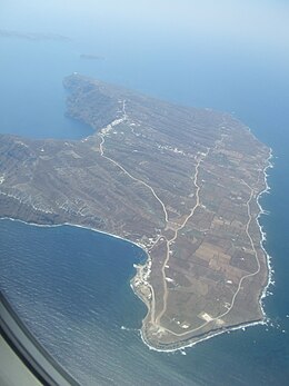
Therasia, also known as Thirasía (Greek: Θηρασία), is an island in the volcanic island group of Santorini in the Greek Cyclades. It lies north-west of Nea Kameni, a small island formed in recent centuries by volcanic activity and thus marking the centre of the island group. Therasia is the second largest island of the group, the largest by far being Thera.
Native name: Θηρασία | |
|---|---|
 | |
 Therasia | |
| Geography | |
| Coordinates | 36.43°N 25.33°E |
| Archipelago | Cyclades |
| Area | 9.3 km2 (3.6 sq mi) |
| Administration | |
Greece | |
| Region | South Aegean |
| Regional unit | Thira |
| Demographics | |
| Population | 319 (2011) |
| Pop. density | 34/km2 (88/sq mi) |
| Additional information | |
| Postal code | 847 02 |
| Area code(s) | 22860 |
| Vehicle registration | EM |
Therasia has a land area of 9.299 square kilometres (3.590 sq mi) and its population was 319 inhabitants at the 2011 census. It is part of the municipal unit of Oia (Δημοτική Ενότητα Οίας).
Thera and Therasia were separated by the Thera eruption.
At Knossos, in a LMIIIA context (14th century BC), seven Linear B texts while calling upon "all the gods" make sure to grant primacy to an elsewhere-unattested entity called qe-ra-si-ja and, once, qe-ra-si-jo. However this probably refers to a god or a person rather than to an island *Qherasia > Therasia.[1] Anciently, the island of Therasia possessed a town of the same name.[2]
Thirasia is also the book of Greek poet Dimitris Varos that became a music album and theatrical performance by Greek composer Giannis Markopoulos under the title Daring Communication - Electric Theseus.
Villages
- Agía Eiríni (pop. 39 in 2011)
- Agrilia (2)
- Manolas (160)
- Ormos Korfou (5)
- Potamos (113)
Historical population
| Census | Settlement |
|---|---|
| 1991 | 233 |
| 2001 | 268 |
| 2011 | 319 |
References
- Minoan Qe-Ra-Si-Ja. The Religious Impact of the Thera Volcano on Minoan Crete
- Ptolemy. The Geography. Vol. 3.15.28.
External links
- Official website (in German, Greek, English, and French)
- Official Facebook Page (in German, Greek, English, and French)
На других языках
[de] Thirasia
Thirasia (griechisch Θηρασία [.mw-parser-output .IPA a{text-decoration:none}θiraˈsia] oder Θηρασιά [θiraˈsja] (f. sg.)) ist eine griechische Insel der Kykladen im ägäischen Meer. Sie bildet den im Anschluss an die sogenannte Minoische Eruption entstandenen westlichen Calderarand. Verwaltungstechnisch zählt die Insel zum Gemeindebezirk Ia der Gemeinde Thira. Nach der Volkszählung 2011 hatte die Insel 319 Bewohner.[1]- [en] Therasia
[fr] Thirassía
Thirassía, en grec moderne : Θηρασία, est une île de Grèce située en mer Égée. Elle forme avec quatre autres îles l'archipel de Santorin. Elle constitue les restes de l'ancienne île de Santorin qui est partiellement détruite vers 1600 av. J.-C. au cours de l'éruption minoenne.[it] Therasia
Therasia, conosciuta anche come Thirasia (in greco: Θηρασία), è un'isola vulcanica dell'arcipelago di Santorini, in Grecia. Si trova a nord-ovest di Nea Kameni e quasi all'esatto opposto della più grande e famosa isola di Thera. Therasia è la seconda isola più grande del gruppo ed è stata divisa da Thera durante l'eruzione di Santorini.[ru] Тирасия
Тираси́я[1][2] (греч. Θηρασία[3]) — остров в Греции, в Эгейском море, второй по величине остров группы Санторин (Тира). Расположен к западу от острова Тиры. Площадь острова составляет 9,246 квадратного километра[4], протяженность береговой линии — 17 километров[3]. Тирасия — один из трёх островов (наряду с Тирой и Аспрониси), образовавшихся около 1627 года до н. э. в результате извержения вулкана Санторина. Входит в общину (дим) Тиру в периферийной единице Тире в периферии Южных Эгейских островах. Население острова 319 жителей по данным переписи 2011 года[5]. Административный центр острова — деревня Тирасия, порт острова — Айия-Ирини (греч.) (рус.. Основное занятие жителей — обслуживание туристов, прибывающих на однодневные экскурсии с острова Тиры.Другой контент может иметь иную лицензию. Перед использованием материалов сайта WikiSort.org внимательно изучите правила лицензирования конкретных элементов наполнения сайта.
WikiSort.org - проект по пересортировке и дополнению контента Википедии
