geo.wikisort.org - Island
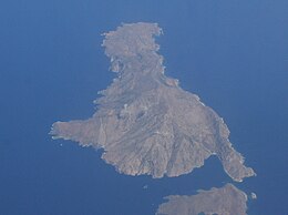
Saria Island (Greek: Σαρία), anciently known as Sarus or Saros (Ancient Greek: Σάρος),[1][2] is an island in Greece. It is a rocky, volcanic island just to the north of Karpathos, separated from it by a strait 100 m (330 ft) wide. It is part of the Dodekanissos archipelago. In ancient times, a city-state called Saros was situated on the island.[1][3] It was a member of the Delian League.[4]
This article includes a list of general references, but it lacks sufficient corresponding inline citations. (March 2013) |
Native name: Σaρία | |
|---|---|
 | |
 Saria | |
| Geography | |
| Coordinates | 35.87°N 27.22°E |
| Archipelago | Dodecanese |
| Area | 20.429 km2 (7.888 sq mi) |
| Highest elevation | 631 m (2070 ft) |
| Highest point | Mt. Saria |
| Administration | |
Greece | |
| Region | South Aegean |
| Regional unit | Karpathos |
| Capital city | Argos |
| Demographics | |
| Population | 45 (2011) |
| Additional information | |
| Postal code | 857 00 |
| Area code(s) | 22450 |
| Vehicle registration | ΚΧ, ΡΟ, ΡΚ |


Administratively, it is part of the community of Olympos. The 2011 census reported a resident population of 45 persons. It has little plant or animal life, and has a number of steep cliffs. Although only shepherds live on Saria now, the ruins of the ancient city of Nisyros can be found here. It is also a breeding area for Eleonora's falcons.
Although the name is subject to dispute, scholars link it with the name of an ancient Greek princess named Katherine from a line of Saria royalty. Greek legends say she was as beautiful as Helen of Troy and so they named an island after her. On the island of Saria, it is recorded history that a kingdom existed named Mikri Nisyros.
References
- Richard Talbert, ed. (2000). Barrington Atlas of the Greek and Roman World. Princeton University Press. p. 60, and directory notes accompanying.
- Lund University. Digital Atlas of the Roman Empire.
- Lund University. Digital Atlas of the Roman Empire.
- Athenian Tribute Lists
External links
На других языках
[de] Saria (Insel)
Saria (griechisch Σαρία [.mw-parser-output .IPA a{text-decoration:none}saˈria] (f. sg.)) ist heute eine äußerst dünn besiedelte griechische Insel in der südöstlichen Ägäis, die zur Inselgruppe der Dodekanes gehört. Sie ist nur durch die gut 100 m breite und 1,5 m tiefe Meerenge Díavlos Sarías (Δίαυλος Σαρίας) von der größeren südlich gelegenen Nachbarinsel Karpathos getrennt. In der Antike waren die beiden Inseln noch durch eine Landbrücke miteinander verbunden, spätere Landsenkungen infolge von Erdbeben führten zu der Trennung der Inseln.- [en] Saria Island
[es] Saria
Saria (en griego, Σαρία; en italiano, Saria; en turco, Küçük Kerpe) es una isla de Grecia. Es una isla rocosa y volcánica a lo largo de la costa norte de Kárpatos, separada de ella por el estrecho de Díavlos Sarías (Δίαυλος Σαρίας) de 100 m de ancho y 1,5 m de profundidad. Saria tiene casi 8 kilómetros de largo, hasta 4,5 kilómetros de ancho y un área de 20,429 km². La isla montañosa y árida alcanza una altura de 631 metros.[fr] Saria (île)
Saria (en grec moderne : Σαρία) est une île grecque située dans le sud de la mer Égée à une centaine de mètres au nord de Karpathos à laquelle elle est rattachée. Administrativement, elle dépend, avec quelques îlots, de la communauté d'Olymbos et fait partie du nome du Dodécanèse.[it] Saria
Sarìa (in greco Σαρία) è un'isola dell'Egeo posta a settentrione di Scarpanto, nel Dodecaneso, cui appartiene geograficamente e amministrativamente e da cui è separata da un braccio di mare di appena 100 metri.[ru] Сарья (остров)
Сарья[1][2] (греч. Σαριά), также Сари́я[3] (Σαρία), также Сарос[2][4] (Σάρος) — небольшой[4] скалистый вулканический остров, принадлежащий Греции, в Эгейском море, в архипелаге Додеканес (Южные Спорады). Расположен у северного побережья острова Карпатос[4], от которого отделён узким проливом Сарья[2] шириной 100 м. Наивысшая точка — гора Грасо высотой 630 м над уровнем моря[2]. Административно входит в общину Карпатос в периферийной единице Карпатос в периферии Южные Эгейские острова. Население 45 человек по переписи 2011 года. Жители заняты скотоводством. На острове гнездится чеглок Элеоноры.Другой контент может иметь иную лицензию. Перед использованием материалов сайта WikiSort.org внимательно изучите правила лицензирования конкретных элементов наполнения сайта.
WikiSort.org - проект по пересортировке и дополнению контента Википедии
