geo.wikisort.org - Island
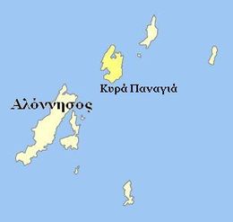
Kyra Panagia (Greek: Κυρά Παναγιά [ci'ra pana'ʝa]) is a Greek island in the Sporades. It is administratively part of the municipality of Alonnisos in the Sporades regional unit. The island is also known by the name of Pelagos and rarely Pelagonisi. In Antiquity it was known as Ephthyros (Έφθυρος) and Polyaigos (Πολύαιγος)[citation needed]. A bay in the south west of the island is named Agios Petros. Kyra Panagia has belonged to the Athonite monastery of Megisti Lavra since it was granted the island by the Byzantine emperor Nikephoros II Phokas in 963. There is a monastery renovated in 2017 after 8 years of work and inhabited by a single monk, on the east coast of the island. As of 2011[update], the resident population of the island was 2.[1] Kyra Panagia is in Zone B of the Alonnisos Marine Park.
Native name: Κυρά Παναγιά | |
|---|---|
 | |
 Kira Panagia | |
| Geography | |
| Coordinates | 39.33°N 24.07°E |
| Archipelago | Sporades |
| Total islands | 2 |
| Highest elevation | 302 m (991 ft) |
| Highest point | Mt. Panagias |
| Administration | |
Greece | |
| Region | Thessaly |
| Regional unit | Sporades |
| Municipality | Alonnisos |
| Demographics | |
| Population | 2 (2011) |
| Additional information | |
| Postal code | 370 05 |
| Area code(s) | 24240 |
| Vehicle registration | BO |
Nearest islands and islets
Its nearest islands and islets are Gioura to the northeast and the main island of Alonnisos to the southwest.
References
- "Detailed census results 2011" (in Greek). National Statistical Service of Greece. Archived from the original (xls 2,7 MB) on 2013-12-25.
External links
- Kyra Panagia (Pelagos) on GTP Travel Pages (in English and Greek)
- Official website of Municipality of Aloníssos (in Greek)
На других языках
[de] Kyra Panagia
Kyra Panagia (griechisch Κυρά Παναγία (f. sg.), Aussprache: [.mw-parser-output .IPA a{text-decoration:none}kʲiˈra panaˈʝia], „Allheilige Herrin“, eine Bezeichnung für Maria) ist eine griechische Insel der Nördlichen Sporaden. Administrativ gehört die Insel zur Gemeinde Alonnisos im Regionalbezirk Sporaden der Region Thessalien. Der Name der Insel stammt von dem gleichnamigen spätbyzantinischen Kloster an der Ostküste.- [en] Kyra Panagia
[fr] Kyrá Panagiá
Kyrá Panagiá (en grec moderne : Κυρά Παναγιά) est une île grecque de l'archipel des Sporades[1]. Elle est administrativement rattachée à la municipalité d'Alonnisos. L'île est également connue sous le nom de Pelagos et plus rarement Pelagonisi. Une baie au sud-ouest de l'île est nommée Ágios Pétros.[ru] Кира-Панайя (остров)
Кира́-Панайя́[1][2] (греч. Κυρά Παναγιά — «Пресвятая Владычица»), также Пелагони́си[1][2] (Πελαγονήσι) — небольшой остров в Греции. Наивысшая точка 299 м над уровнем моря[1][2]. Остров находится в Эгейском море и является частью архипелага Северные Спорады. Остров скалист и по берегам сильно изрезан бухтами. Площадь острова составляет 24,973 км²[3]. Остров в древности назывался Поли́егос (лат. Polyaigos, Πολύαιγος)[4]. Ближайшим островом на северо-востоке является Юра и на юго-западе Алонисос[1]. Административно относится к общине Алонисос в периферийной единице Спорады в периферии Фессалия. Население 2 человека по переписи 2011 года[5].Другой контент может иметь иную лицензию. Перед использованием материалов сайта WikiSort.org внимательно изучите правила лицензирования конкретных элементов наполнения сайта.
WikiSort.org - проект по пересортировке и дополнению контента Википедии
