geo.wikisort.org - Island
Uzunada or Uzun ada (literally "long island") is an island situated at the entry of the Gulf of İzmir on the west coast of Turkey.

It is situated between the Karaburun Peninsula, Turkey in the west, and the district of Foça in the east. Stretching over a length of c. 9 kilometres (6 miles) in north-south direction, it is Turkey's fourth largest island, and its third largest in the Aegean Sea.
The island has been called by many names. Its ancient Greek name was Drymoussa (Δρυμούσσα), and it is also known under its later Greek names of Makronisi ("long island") or Englezonisi ("Englishmen's island"),[1][2] but more likely is that this name is derived from the word Enclazomenisi from ancient city Clazomenae at the opposite coast. To its south are several smaller islets, including Yassıca. It has also been called "Chustan Island" (or Keustan).[3]
"Uzunada" is also the name of several other, smaller islets along the Turkish Aegean coast.[2] Uzunada is currently closed to settlements due to military activities.
History
Thucydides briefly mentions Drymoussa as a location where some ships of Astyochus put in for eight days during a period of high winds in the 20th year of the Peloponnesian War.[4]
After the Treaty of Apamea was concluded in 188 B.C., the city of Clazomenae was awarded the island.[5][6][7]
Despite claims of ownership of an English family dating from the mid-19th century, by 1914 there were about 2,000 Ottoman Greeks living on the island.[8]
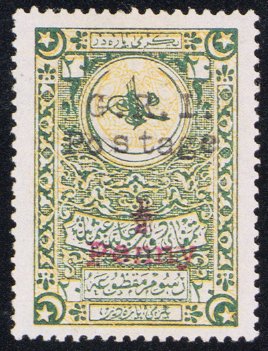
During World War I, the British Mediterranean Fleet occupied the island (referred to as "Chustan") in 1916, where they also issued some rare stamps.[9][10]
After the population exchange between Greece and Turkey, most of the island's former inhabitants settled in Nea Ionia, Magnesia.[11]
References
- (16 Nov 2012). UZUNADA KİMİN?, Yeni Asır (article in Turkish re island ownership, notes prior name of "Englezonisi (İngilizlerin adası)")
- US GeoNames database
- Mediterranean Pilot, Volume 4, pp. 191-92 (4th ed. 1908)
- Thucydides, 8.31 (" He was himself carried to Phocaea and Cymè, and the remainder of the fleet put into the islands, Marathussa, Pelè, and Drymussa, which lie off Clazomenae. There, being detained eight days by the weather, they spoiled and destroyed part of the property of the Clazomenians which had been deposited in the islands")
- A Dictionary of Greek and Roman Geography, Volume 1, p. 632 (1872)
- Pinkerton, John. A general collection of ... voyages and travels, Vol. X, p. 653 (1811)
- Bowyer, W. A Description of the East and Some Other Countries, Vol. 2, Part 2, p. 41 (1745)
- Turkish Island Romance, Akaroa Mail and Banks Peninsula Advertiser, Volume LI, Issue 5241, 10 December 1926, Page 1 (reprinted from The London Times)
- Stamp Collectors will be Kept Busy, The Tomahawk (date?)
- SMALL ISLANDS IN THE NEAR EAST, PHILATELIC EXPERTS, Retrieved 22 May 2015
- "Εγγλεζονήσι, πολιτιστικός σύλλογος Νέας Ιωνίας Μαγνησίας". Archived from the original on 2013-07-16. Retrieved 2011-08-12.
External links

На других языках
- [en] Uzunada
[fr] Uzunada
Uzunada ou Uzun Ada (littéralement « île longue ») est une île située à l'entrée du golfe d'Izmir, sur la côte ouest de la Turquie[1]. Elle est située entre la péninsule de Karaburun à l'ouest et le district de Foça à l'est. Avec un trajet Nord/Sud long de 9 km, elle est la quatrième plus grande île de la Turquie, et la troisième plus grande de la mer Égée. Son ancien nom grec était Drymoussa (Δρυμούσσα), l'île est également connue par les noms grecs postérieurs de Makronisi (« île longue ») ou Englezonisi (« île des Anglais »). Au sud de l'île sont situés de nombreux îlots dont Yassıca.[ru] Узунада
Узунада (тур. Uzunada) — остров, расположенный у входа в Измирский залив на западном побережье Турции. В переводе с турецкого буквально «длинный остров». Расположен между полуостровом Карабурун на западе и районом Фоча на востоке. Протяжённость острова с севера на юг составляет 9 км. Это четвёртый по площади остров Турции. К югу от него находится несколько небольших островков, в том числе Яссыка.Другой контент может иметь иную лицензию. Перед использованием материалов сайта WikiSort.org внимательно изучите правила лицензирования конкретных элементов наполнения сайта.
WikiSort.org - проект по пересортировке и дополнению контента Википедии