geo.wikisort.org - Island
Donousa (Greek: Δονούσα, also Δενούσα Denousa), and sometimes spelled Donoussa, is an island and a former community in the Cyclades, Greece. Since the 2011 local government reform it is part of the municipality Naxos and Lesser Cyclades, of which it is a municipal unit.[2] Donousa is the easternmost island of the Lesser Cyclades.
Donousa
Δονούσα | |
|---|---|
 | |
 Donousa Location within the regional unit 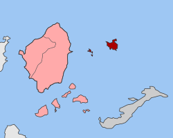 | |
| Coordinates: 37°06′0″N 25°48′59″E | |
| Country | Greece |
| Administrative region | South Aegean |
| Regional unit | Naxos |
| Municipality | Naxos and Lesser Cyclades |
| • Municipal unit | 13.750 km2 (5.309 sq mi) |
| Highest elevation | 385 m (1,263 ft) |
| Lowest elevation | 0 m (0 ft) |
| Population (2011)[1] | |
| • Municipal unit | 167 |
| • Municipal unit density | 12/km2 (31/sq mi) |
| Time zone | UTC+2 (EET) |
| • Summer (DST) | UTC+3 (EEST) |
| Postal code | 843 00 |
| Area code(s) | 22850 |
| Vehicle registration | EM |
| Website | www |
Geography
Donousa is located 16 km (10 mi) east of the island of Naxos and about 25 km (16 mi) north of Amorgos. Its area is 13.75 square kilometres (5.31 sq mi)[3] and its highest point is 385 metres (1,263 ft). Its population is 167 inhabitants (2011 census), most of which live in the main settlement Donousa (also Stavros). Other villages include Mersini (on the southeastern coast), Kalotaritissa (near its northern coastline) and Charavgi (in the south).
| Year | Pop. | ±% p.a. |
|---|---|---|
| 1928 | 235 | — |
| 1946 | 250 | +0.34% |
| 1981 | 116 | −2.17% |
| 1991 | 111 | −0.44% |
| 2001 | 163 | +3.92% |
| 2011 | 167 | +0.24% |
History
Tracing all the way back to ancient Greek mythology in the prehistoric times, Dionysus, the god of winemaking and wine, took Ariadne from Naxos to hide her from Theseus.[4] There is also evidence of inhabitation on Donousa during the Early Cycladic period, around 3,000 BC.[4]
The island during the Roman times, was additionally considered to be the place where exiles were deported. Later, it became the favourite hideout spot of Mediterranean pirates.[5] Throughout time, the island was ruled by various civilisations including the Venetians and Turks.[4]
Towns
Agios Stavros is the main port and capital of Donousa. When visiting the Agios Stavros port and town, one will find a variety of taverns, cafes, bakeries, mini markets, rooms for rental and other touristic facilities.[5]
Other towns and villages on the island include Kalotaritissa, Haravgi and Mersini.[6]
References
- "Απογραφή Πληθυσμού - Κατοικιών 2011. ΜΟΝΙΜΟΣ Πληθυσμός" (in Greek). Hellenic Statistical Authority.
- "ΦΕΚ B 1292/2010, Kallikratis reform municipalities" (in Greek). Government Gazette.
- "Population & housing census 2001 (incl. area and average elevation)" (PDF) (in Greek). National Statistical Service of Greece. Archived from the original (PDF) on 2015-09-21.
- "History of Donoussa island | Greeka". Greekacom. Retrieved 2021-06-30.
- "Donousa Greece | Greece.com". www.greece.com. Retrieved 2021-06-30.
- "Donousa". VisitGreece. Retrieved 2021-06-30.

Authority control | |
|---|---|
| General |
|
| National libraries | |
На других языках
[de] Donousa
Die griechische Insel Donousa (griechisch Δονούσα [.mw-parser-output .IPA a{text-decoration:none}ðɔˈnusa] (f. sg.)) gehört innerhalb der Kykladen zur Gruppe der Kleinen Kykladen. Seit 2011 bildet sie mit einigen weiteren, unbewohnten kleinen Inseln einen Gemeindebezirk der Gemeinde Naxos und Kleine Kykladen in der Region Südliche Ägäis.- [en] Donousa
[es] Donusa
La isla de Donusa (también Donousa o Denusa) (en griego, Δονούσα) es una pequeña isla griega del mar Egeo perteneciente al archipiélago de las Cícladas y que está próxima a la isla de Naxos, al este, y también al este de la isla de Amorgos. Tiene una superficie de 13,75 km² y solamente 163 habitantes en 2001. La altura máxima de la isla se alcanza en el monte Papas (383 m).[ru] Донуса
Донуса[1] (греч. Δονούσα[2]) — остров в Эгейском море. Расположен в юго-восточной части архипелага Киклады, между Аморгосом и Наксосом, примерно в 15 км к востоку от острова Наксоса. Входит в группу небольших островов Малые Киклады. Площадь острова составляет 13,652 квадратного километра[2], протяженность береговой линии — 30 километров[3]. Наивысшая точка — 363 м. Административно входит в общину Наксос и Малые Киклады в периферийной единице Наксос в периферии Южные Эгейские острова[4]. Административный центр — одноимённая деревня на юго-западном побережье. Население острова 167 жителей по переписи 2011 года[4]. В настоящее время основными занятиями жителей является сельское хозяйство. Развивается и сфера обслуживания туристов.Другой контент может иметь иную лицензию. Перед использованием материалов сайта WikiSort.org внимательно изучите правила лицензирования конкретных элементов наполнения сайта.
WikiSort.org - проект по пересортировке и дополнению контента Википедии