geo.wikisort.org - Island
Gyali (Greek: Γυαλί "glass", also spelled Giali or Yali, pronounced [ʝaˈli]) is a volcanic Greek island in the Dodecanese, located halfway between the south coast of Kos (Kardamaina) and Nisyros. It consists of rhyolitic obsidian lava domes and pumice deposits (which are mined in huge quantities).[1] The island has two distinct segments, with the northeastern part almost entirely made of obsidian and the southwestern part of pumice. These are connected by a narrow isthmus and beach made of modern reef sediments. Anciently, the island was known as Istros (Ancient Greek: Ἴστρος).[2]
Native name: Γυαλί | |
|---|---|
 Pumice mining on Gyali | |
 Gyali | |
| Geography | |
| Coordinates | 36.662°N 27.115°E |
| Archipelago | Dodecanese |
| Area | 4.558 km2 (1.760 sq mi) |
| Highest elevation | 180 m (590 ft) |
| Highest point | Volcano |
| Administration | |
Greece | |
| Region | South Aegean |
| Regional unit | Kos |
| Capital city | Chora |
| Demographics | |
| Population | 10 (2001) |
| Additional information | |
| Postal code | 853 03 |
| Area code(s) | 22420 |
| Vehicle registration | ΚΧ, ΡΟ, ΡΚ |
Geography
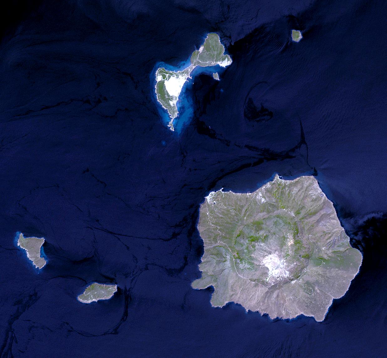
The island is 6 km (4 mi) long and between 4 km (2 mi) and 500 m (1,640 ft) across. It has a 180 m (591 ft) cave. Parts of the island undergoing pumice strip mining are barren of vegetation. The 2001 census reported a resident population of 10 people. Administratively, it is part of the municipality of Nisyros. Its also popular for Perli, a thermo powder added in construction.
See also
References
- "Yali". Global Volcanism Program. Smithsonian Institution. Retrieved 2008-01-22.
- Lund University. Digital Atlas of the Roman Empire.
External links
- Official website of Municipality of Nisyros (in English, French, German, Greek, Italian, and Spanish)

Authority control | |
|---|---|
| General |
|
| National libraries | |
| Other | |
This South Aegean location article is a stub. You can help Wikipedia by expanding it. |
На других языках
[de] Gyali
Gyali (griechisch Γυαλί (n. sg.) [.mw-parser-output .IPA a{text-decoration:none}ʝaˈli] ‚Glas‘) ist eine griechische Insel in der Inselgruppe der Dodekanes. Sie gehört zum Hauptort Mandraki der Gemeinde Nisyros in der Region Südliche Ägäis.- [en] Gyali
[es] Gyali
Gyali (Griego moderno: Γυαλί "pequeño cristal", conocida en la antigüedad como Istros, también llamada Yiali o Yali, pronunciado [ʝaˈli]) es una isla griega volcánica del archipiélago del Dodecaneso localizada a medio camino entre la costa meridional de Cos y la isla de Nisiros. Se compone de colinas de lava de obsidiana riolítica y de depósitos de piedra pómez.[1]La isla depende administrativamente de Nisiros.[fr] Gyalí
Gyalí (en grec moderne : Γυαλί signifiant « verre ») est une petite île de la mer Égée située dans le Dodécanèse et administrativement rattachée à l'île de Nissiros située à environ 3 km au sud. Véritable carrière à ciel ouvert, Gyali est exploitée pour ses ressources en pierres ponces.[it] Gyali
Gyali (in greco Γυαλί cioè "vetro") è un'isola greca di origine vulcanica, appartenente all'arcipelago del Dodecaneso. Essa è situata a metà strada tra la costa meridionale di Coo, e l'isola di Nisiro al cui comune è collegata amministrativamente.[ru] Яли (остров)
Яли́[1] (греч. Γυαλί «стекло») — греческий вулканический остров в Эгейском море. Расположен к югу от Коса и к северу от Нисироса. Входит в группу островов Додеканес. Население 21 житель по переписи 2011 года[2]. Площадь острова составляет 4,558 квадратного километра[3]. Длина острова в направлении с юго-запада на северо-восток — 5 километров, ширина — 0,5—2 километра.Другой контент может иметь иную лицензию. Перед использованием материалов сайта WikiSort.org внимательно изучите правила лицензирования конкретных элементов наполнения сайта.
WikiSort.org - проект по пересортировке и дополнению контента Википедии