geo.wikisort.org - Island
Agios Efstratios or Saint Eustratius (Greek: Άγιος Ευστράτιος), colloquially Ai Stratis (Greek: Άη Στράτης), anciently Halonnesus or Halonnesos (Ancient Greek: Ἁλόννησος),[3] is a small Greek island in the northern Aegean Sea about 30 kilometres (19 miles) southwest of Lemnos and 80 kilometres (50 miles) northwest of Lesbos. The municipality has an area of 43.325 km2.[4] Together with Lemnos and nearby islets it forms the regional unit of Lemnos, part of the Greek archipelagic region of the North Aegean.
Agios Efstratios
Άγιος Ευστράτιος | |
|---|---|
 Agios Efstratios village | |
 Agios Efstratios Location within the region  | |
| Coordinates: 39°31′N 25°00′E | |
| Country | Greece |
| Administrative region | North Aegean |
| Regional unit | Lemnos |
| Area | |
| • Municipality | 43.325 km2 (16.728 sq mi) |
| Population (2011)[1] | |
| • Municipality | 270 |
| • Municipality density | 6.2/km2 (16/sq mi) |
| Time zone | UTC+2 (EET) |
| • Summer (DST) | UTC+3 (EEST) |
| Postal code | 815 00[2] |
| Area code(s) | 2254 |
| Vehicle registration | ΜΗ, ΜΥ |
Name
Anciently the island was known as Halonnesus, and under this name was a bone of contention between ancient Athens and Macedon as was noted in On the Halonnesus, attributed to Demosthenes. The island was named after Saint Eustratius (Όσιος Ευστράτιος ο Θαυματουργός), who lived on the island in the 9th century as an exile, because he was opposed to the iconoclastic policies of the Byzantine Emperor Leo the Armenian. His grave is still being shown by the inhabitants. The island is mentioned in the Isolario by Cristoforo Buondelmonti in 1420 as Sanstrati. It was also known as "Bozbaba" during Ottoman rule. The Ottoman Census of 1831 states that the Island was composed of exclusively Greeks and that there were 310 Greek males of fit to fight. This registrar did not register women, orphans, Christians below the age of puberty, the mentally or physically incapacitated as well as high - ranking officials, so the actual population would be much higher.[5]
Geography

Agios Efstratios is quiet, isolated and dry, with a population of approximately 300 people. The climate is arid, with little rainfall during the winter months and long, hot summers. The landscape is mostly rocky, with scarce and low vegetation. Locust infestation is a recurring problem.[6] Crops are insignificant; the surrounding sea, however, is rich in fish which are fished by local fishermen. There are numerous beaches on the island such as Agios Antonios, Lemonies, Avlakia and others, most of which are reached by caique. Agios Efstratios Island is linked by boat with Limnos, Agios Konstantinos, Kymi and Kavala.
Recent political history

The island was used to house political prisoners in internal exile since the 1930s. The first communists were exiled to the island with the Idionymon law of Venizelos, later during the Metaxas Regime and again during the Greek civil war. After Makronisos it became the largest prison island in Aegean. During the Greek military junta of 1967–74, the island was again used as a prison for political dissidents. Exiles here included Ilias Iliou, Stefanos Sarafis, Dimitris Glinos, Kostas Varnalis, Tasos Leivaditis, Yiannis Ritsos, Menelaos Lountemis, Manos Katrakis and Mikis Theodorakis.
On 19 February 1968, an earthquake (7.1 on the Richter scale) demolished most of the houses,[7] which were replaced by concrete prefabricated buildings laid out in a military-like camp formation. Nonetheless, the island retains a very attractive capital, also called Agios Efstratios, while preserving a rather unspoiled Mediterranean environment with pristine beaches. It is mostly a place for relaxation and meditation.
Greece's first green island
Athens News Agency[8] reported that, on 4 June 2009, at a two-day international conference in Athens on "Climate change and Challenges for the Future Generations"[9] under the patronage of UNESCO, Greece's Development Minister Kostis Hatzidakis said that Agios Efstratios would soon become the country's first "green" island, entirely powered by renewable energy sources (RES), its residents relying on solar and wind generated energy and moving around the island on bicycles and in electric cars. Hatzidakis said a €10 million project would be implemented by 2010. At the same conference Professor Philippos Tsalidis, Development Ministry General Secretary for Research and Technology, said that although Greece's energy needs currently required strategic reliance on natural gas, Aghios Efstratios, could serve as a global model for 100% reliance on RES. Agios Efstratios is included in the European Union's Natura 2000 network of nature protected areas.
Transportation
Agios Efstratios has one port, which offers year-round ferry connections to the island of Lemnos, as well to mainland Greece, namely Lavrio. The ship operating these routes is owned by Hellenic Seaways. There is also a small heliport on the main village outskirts, but it is used mostly for emergency airlift, or coast guard and military helicopters' stopover.
Appearance in popular media
Agios Efstratios serves as the basis for the fictional island of Stratis in the 2013 video game Arma 3, along with its northern counterpart of Lemnos, fictionalized as "Altis", the governing body of the two islands. However, "Stratis" in Arma 3 has some critical differences from Agios Efstratios, including numerous additional military bases scattered around the island in-game, and a large airport built off artificial land into the sea south-west of the village of Agios Efstratios.
In the game, it is located south of Altis, based on Lemnos. The Republic of Altis and Stratis is located just south of Malta in the game, as opposed to east of Greece.
Gallery
 View
View Overview
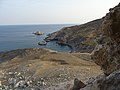 Alonitsi beach


References
- "Απογραφή Πληθυσμού - Κατοικιών 2011. ΜΟΝΙΜΟΣ Πληθυσμός" (in Greek). Hellenic Statistical Authority.
- "Find a Postcode". Retrieved 2 June 2013.
- Lund University. Digital Atlas of the Roman Empire.
- "Population & housing census 2001 (incl. area and average elevation)" (PDF) (in Greek). National Statistical Service of Greece. Archived from the original (PDF) on 2015-09-21.
- Kemal Karpat (1985), Ottoman Population, 1830-1914, Demographic and Social Characteristics, The University of Wisconsin Press, p. 9 & 114
- BBC News 20/05/2017
- Επίτομο Γεωγραφικό Λεξικό της Ελλάδος (Geographical Dictionary of Greece), Μιχαήλ Σταματελάτος, Φωτεινή Βάμβα-Σταματελάτου, εκδ. Ερμής, ΑΘήνα 2001
- [dead link]
- International Conference: Climate Change and Challenges for the Future Generations Archived June 8, 2009, at the Wayback Machine
External links
- Documentary about Agios Efstratios
- Ship Routes to Agios Efstratios
- Municipality of Agios Efstratios Official Page - Δήμος Αγίου Ευστρατίου Επίσημη Ιστοσελίδα
- Agios Efstratios Sea Pilot Archived 2016-03-03 at the Wayback Machine

Administrative division of the Northern Aegean Region | ||
|---|---|---|
| ||
| Regional unit of Chios | 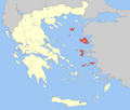 | |
| Regional unit of Ikaria | ||
| Regional unit of Lemnos | ||
| Regional unit of Lesbos |
| |
| Regional unit of Samos |
| |
| ||
Authority control | |
|---|---|
| General |
|
| National libraries | |
На других языках
[de] Agios Efstratios
Die griechische Insel Agios Efstratios (griechisch Άγιος Ευστράτιος (m. sg.)), von den Bewohnern Ai Stratis (Άη Στράτης) genannt, bildet zusammen mit einigen Felseninseln eine Gemeinde und gemeinsam mit Limnos den Regionalbezirk Limnos in der Region Nördliche Ägäis. Nach der Volkszählung von 2011 zählt die Insel 270 Bewohner.- [en] Agios Efstratios
[fr] Ágios Efstrátios
Ágios Efstrátios ou Áyios Efstrátios (grec moderne : Άγιος Ευστράτιος), ou Saint-Eustrate, connue dans l’Antiquité sous le nom d’Halon(n)èse (grec ancien : Ἁλόνησος ou Ἁλόννησος / Halón(n)ēsos, « l’île du sel ») est une petite île grecque, au nord-est de la mer Égée 30 km au sud-ouest de Lemnos et 80 km au nord ouest de Lesbos. Elle forme un dème (municipalité) de la périphérie d'Égée-Septentrionale, dans le district régional de Lemnos.[it] Agiostrati
Agiostrati[1] (in greco: Άγιος Ευστράτιος, Agios Efstratios, nota nel dialetto locale come Άη Στράτης, Ai Stratis) è un'isola della Grecia del Mar Egeo situata a circa 30 km a sud-ovest da Lemno e 80 km a nordovest da Lesbo. Dal punto di vista amministrativo è un comune nella periferia dell'Egeo Settentrionale (unità periferica di Lemno) con 371 abitanti al censimento 2001.[2][ru] Айос-Эфстратиос
А́йос-Эфстра́тиос[1][2] (греч. Άγιος Ευστράτιος, Агиос-Стратис[3], Άη Στράτης) — остров в северной части Эгейского моря, принадлежит Греции[4]. Входит в группу Северо-Восточных островов[5][4]. Располагается в 30 км к юго-западу от острова Лемнос и в 80 км к северо-западу от Лесбоса. Административно входит в периферийную единицу Лемнос в периферии Северные Эгейские острова[5].Другой контент может иметь иную лицензию. Перед использованием материалов сайта WikiSort.org внимательно изучите правила лицензирования конкретных элементов наполнения сайта.
WikiSort.org - проект по пересортировке и дополнению контента Википедии