geo.wikisort.org - Island
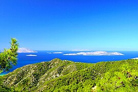
Alimia (Greek: Αλιμιά) or Alimnia (Αλιμνιά) is a Greek island of the Aegean Sea, located in the sea area between Rhodes and Halki, the complex of Dodecanese. The surface of the island is 7.4 square kilometres (2.9 square miles) and has a coastline of 21 kilometres (13 miles). The island had a small population until the period of the Second World War, and in recent decades has remained uninhabited.
Alimia
Αλιμιά | |
|---|---|
 Alimia, Greece | |
| Coordinates: 36°16′N 27°42′E | |
| Country | Greece |
| Administrative region | South Aegean |
| Highest elevation | 274 m (899 ft) |
| Lowest elevation | 0 m (0 ft) |
| Population | |
| • Municipality | 0 |
| Time zone | UTC+2 (EET) |
| • Summer (DST) | UTC+3 (EEST) |
The island is mentioned in ancient texts as Eulimna (Ancient Greek: Εὔλιμνα)[1] and by Pliny the Elder under the name Evlimnia and associated with two large bays of the island, Emporio and Saint George, in the eastern and western side of the island that are safe natural harbors. Their use in antiquity is confirmed by the impressive, carved into the rock, dockyards, dating to the Hellenistic period when it belonged to the Rhodian state. In the Hellenistic period, flourished when the Rhodian state, the island was fortified with the construction of the fortress and used as anchorage and observatory for the Rhodian fleet. The Hellenistic castle survived until today in the highest peak east of the island. A department of a Hellenistic castle was used for the construction of a medieval castle in 1475, when Rhodes and its surrounding islands were occupied by the Knights Hospitaller. On the coast of Emporio found Roman tombs and visible ancient walls and the foundation of an early Christian basilica.
The settlement of Alimia is built deep in the largest bay on the island. It includes several buildings, most of which are dilapidated due to the abandonment of the settlement from the 1940s. Although abandoned, the settlement has declared traditional since 1978. Northwest of the village, a short distance from the coast there is a small lake with salty water, which is one of the 37 natural wetlands in the Dodecanese.
In October 2016 a Belgian organization called 'Beyond Borders Belgium'[2] dropped 20 people on this uninhabited island. The participants had to survive 10 days with hardly any food or equipment. Personal belongings like a cellphone, mattress or clean cloths were not allowed. Each day the participants had to play a game on the island to earn points. At the end of the "vacation" the participant with the most points wins the challenge. The game is based on a former Belgian TV-format called 'Expeditie Robinson'. The Greek government agreed with this concept and gave Beyond Borders Belgium exclusive rights of the island for the full period of 10 days.
References
- Lund University. Digital Atlas of the Roman Empire.
- "Beyond Borders" (in Dutch). Retrieved 9 June 2016.
External links
На других языках
[de] Alimia
Die griechische Mittelmeer-Insel Alimia (griechisch Αλιμιά [.mw-parser-output .IPA a{text-decoration:none}aliˈmja] (f. sg.)), auch Almia, meist Alimnia (griechisch Αλιμνιά) gehört zur Inselgruppe Dodekanes in der Ägäis. Die Insel wird von der Gemeinde Chalki innerhalb der Region Südliche Ägäis (Περιφέρεια Νότιου Αιγαίου) verwaltet.- [en] Alimia
[fr] Alimniá
Alimniá (grec moderne : Αλιμνιά) ou Alimiá (Αλιμιά) est une ile grecque appartenant à l'archipel du Dodécanèse dans la mer Égée, située entre les îles de Rhodes et de Chálki.[it] Alinnia
Alinnia o Alinnià[1] (o anche Limonia; secondo la pronuncia greca Alimnià) è un'isola greca desertica del Mar Egeo, sita in una posizione che si trova ad ovest rispetto all'isola di Rodi ed a nord-est rispetto alla stessa isola di Creta. Assieme all'isola di Calchi, situata leggermente più a sud, rappresenta uno degli esempi più interessanti dal punto di vista naturalistico di tutto il Dodecaneso, nonché da quello storico (grazie alla presenza di diversi forti). In particolare si ricorda quello costruito alla fine del XV secolo da parte del cardinale francese Pierre d'Aubusson. L'isolotto è facilmente raggiungibile in poco tempo dal porto di Skala a Kritinia, a Rodi, ed offre inoltre un mare ricco di vita e particolarmente adatto alle esplorazioni subacquee.[ru] Алимья
Алимья́ (греч. Αλιμιά), или Алимния́[1][2] (Αλιμνιά) — остров в Эгейском море, принадлежит Греции. Входит в группу островов Додеканес (Южные Спорады). Алимья расположена между островами Родос и Халки. Площадь составляет около 7 км², протяжённость береговой линии — 22 км[3]. Самая высокая точка острова — 268 метров над уровнем моря[1][2]. Административно входит в общину Халки в периферийной единице Родос в периферии Южные Эгейские острова. Согласно переписи населения 2011 года, остров является необитаемым[4].Другой контент может иметь иную лицензию. Перед использованием материалов сайта WikiSort.org внимательно изучите правила лицензирования конкретных элементов наполнения сайта.
WikiSort.org - проект по пересортировке и дополнению контента Википедии

