geo.wikisort.org - Island
Cunda Island, also called Alibey Island, (Turkish: Cunda Adası, Alibey Adası), Greek Moschonisi (Greek: Μοσχονήσι or Μοσχόνησος), is the largest of the Ayvalık Islands archipelago in Turkey, which was historically called the Εκατόνησα (Hekatonisa) or Μοσχονήσια (Moschonisia) archipelago in Greek. It lies in the Edremit Gulf on the Turkey's northwestern coast, off the coast of Ayvalık in Balıkesir Province, Turkey, with an area of 23 square kilometres (9 sq mi). It is located 16 kilometres (10 miles) east of Lesbos, Greece.
Cunda Island | |
|---|---|
Island, District | |
 A view from Cunda (Alibey Island) | |
 Cunda Island Location in Turkey | |
| Coordinates: 39°21′38″N 26°38′34″E | |
| Country | |
| Province | Balikesir Province |
| Population | |
| • Total | 3,321 |
| Time zone | UTC+3 (TRT) |


History
Antiquity
According to written sources, there have been settlements since the antiquity; the sources mention the settlements of Nasos (Greek: Νάσος), Pordoselini or Pordoselene (Greek: Πορδοσελήνη) and Chalkis (Greek: Χαλκίς).[1]
20th Century
According to the Ottoman General Census of 1881/82-1893, the kaza of Cunda (Yunda) had a total population of 4.671, consisting of 4.417 Greeks, 89 Muslims and 165 foreign citizens.[2]
Until the Treaty of Lausanne (1923) the entire population of the island was Greek.[3] In 1913, Mehmed Reshid visited the island and he suggested the settlement of wealthy Muslim muhacirs on the island in order to control the Greek population.[4] In 1914, persecution against the population started, resulting in the departure of many inhabitants from the island.[5] The bishop Photios, various priests and prominent men were seized, beaten and imprisoned in a mill, to be released only after some days had passed. Men and women were beaten and tortured.[6] Later,[when?] the inhabitants were deported to Aivali (the Greek name for Ayvalık) on the mainland without being allowed to take anything with them. In Aivali they shared the same fate of oppression with its Christian inhabitants until they were all deported, and scattered among the Turkish villages of the vilayets of Izmir and Bursa. There they were daily subjected to all kinds of persecutions and dying in great numbers. The churches on the island were looted and turned into warehouses and stables, the lamps and holy images in them were broken, paintings of art destroyed and houses rendered uninhabitable.[5][6] In 1915, inhabitants of the island were compelled to pay 2,500 Turkish pounds for the uniforms of the Turkish army and 2,000 Turkish pounds for the construction of barracks; to pay a wheat-tax for the upkeep of the navy, and to buy, at no cheap price, post-cards. Also, some inhabitants were killed and tortured.[6]
For a short period (1921–1922), the island was the see of a Greek Orthodox metropolitan bishop, while the neoclassical mansion of the last metropolitan, Ambrosios, who was executed by the Turkish army, still survives on the seafront of the island's town center.[7] On September 19, 1922 several hundred of the Greek islanders were killed on Cunda; only some children were spared and sent to orphanages.[8] The next year, following the Treaty of Lausanne and the population exchange between Greece and Turkey, the few remaining islanders were forced to leave for Greece and were replaced by Cretan Turks and Turks from Lesbos.
Present day
Cunda Island has the character of a typical Aegean resort town. There are frequent bus and ferry services to Cunda Island from the town center of Ayvalık. Cunda Island is connected to Lale Island, and thence to the mainland, by a bridge and causeway built in the late 1960s. This is the first and currently the oldest surviving bridge in Turkey that connects lands separated by a strait.
The main landmark of Cunda Island remains the Taxiarchis Church (Turkish: Taksiyarhis Kilisesi). The large, former Greek Orthodox cathedral was abandoned and dilapidated, but has now been restored and houses one of the Rahmi M. Koç Museums. Poroselene (Greek: Ποροσελήνη) bay in the north of the island is among Cunda's main sights. In antiquity, it was the home of a dolphin which saved a drowning boy, according to a story mentioned by Pausanias.
In 2007, after a two-year work, all 551 buildings in Cunda Island were inspected and registered by the Turkish Science Academy and Yıldız Technical University Faculty of Architecture, as part of the "Culture of Turkey inventory project".[9]
USA-based Harvard University and Turkey's Koç University have established a joint project in Cunda Island and run a "Harvard-Koç University Intensive Ottoman & Turkish Summer School" every summer.[10][11]
The Ayvalık Strait Bridge connects Cunda Island with Lale Island.
In 2020, the Greek monastery of Saint Demetrius, also known as Ai Dimitri Monastery, which has been built in 1766 with donations from the citizens of Cunda, was completely destroyed by treasure hunters.[12]
Gallery
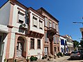 Houses in Cunda Island
 Paterica Cove
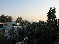 Camping area in Cunda
 Taksiyarhis Church
 Taksiyarhis Church
 A street from Cunda Island
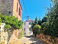 Paved walkways of Cunda Island
 Cunda Island Windmill
 Cats of Cunda Island


See also
References
- Ayvalık Industrial Landscape
- Kemal Karpat (1985), Ottoman Population, 1830-1914, Demographic and Social Characteristics, The University of Wisconsin Press, p. 130-131
- Güven, Mine; Akar, Didar; Öztürk, Balkız; Kelepir, Meltem (2016). Exploring the Turkish Linguistic Landscape: Essays in honor of Eser Erguvanlı-Taylan. John Benjamins Publishing Company. p. 58. ISBN 978-9027259400.
- Kieser, Hans-Lukas (2016). World War I and the End of the Ottomans: From the Balkan Wars to the Armenian Genocide. I.B.Tauris; Sew edition. ISBN 978-1784532468.
- Persecution of the Greeks in Turkey, 1914–1918. Constantinople [London, Printed by the Hesperia Press]. 1919.
- Persecutions of the Greeks in Turkey since the beginning of the European war. Greece. Hypourgeio Exoterikon. 1918.
- Charitopoulos, Evangelos. "Diocese of Moschonisia" (in Greek). Εγκυκλοπαίδεια Μείζονος Ελληνισμού, Μ. Ασία. Archived from the original on 3 February 2014. Retrieved 14 October 2012.
- Clark, Bruce (2006). Twice a stranger : the mass expulsion that forged modern Greece and Turkey. Cambridge (Massachusetts): Harvard University Press. p. 25. ISBN 9780674023680.
On the nearby islet which is known in Greek as Moschonisi and in Turkish as Cunda, several hundred civilians of all ages were taken away and killed, only some of the children were spared and sent to orphanages
- NTV MSNBC. "Cunda evlerine nüfus kağıdı" (in Turkish). Retrieved 2009-03-31.
- "Intensive Ottoman Summer School in Turkey". Near Eastern Languages and Civilizations. Harvard Summer School 2008. Archived from the original on 2008-04-05. Retrieved 2008-04-26.
- "Department of History". Koç University. 16 July 2007. Archived from the original on 2008-10-07. Retrieved 2008-04-26.
- Treasure hunters destroy historic chapel in Aegean town
External links

| Black Sea |
| ||||||||||
|---|---|---|---|---|---|---|---|---|---|---|---|
| Marmara Sea |
| ||||||||||
| Aegean Sea |
| ||||||||||
| Mediterranean |
| ||||||||||
| Lake Van |
| ||||||||||
На других языках
[de] Alibey Adası
Alibey Adası oder auch Cunda Adası (griechisch Μοσχονήσι Moschonisi oder Μοσχόνησος .mw-parser-output .Latn{font-family:"Akzidenz Grotesk","Arial","Avant Garde Gothic","Calibri","Futura","Geneva","Gill Sans","Helvetica","Lucida Grande","Lucida Sans Unicode","Lucida Grande","Stone Sans","Tahoma","Trebuchet","Univers","Verdana"}Moschonisos) ist die größte Insel vor Ayvalık in der Westtürkei und die viertgrößte des ganzen Landes. Sie liegt im Golf von Edremit im Ägäischen Meer. Die Insel ist 23 km² groß und ist 16 km von Lesbos entfernt. Alibey gehört zu einem Archipel von 22 Inseln, die alle außer Alibey nicht besiedelt sind und seit 1995 einen Nationalpark bilden. Administrativ gehört Alibey zur Gemeinde Ayvalık und ist in die Mahalle Mithatpaşa und Namık Kemal eingeteilt. Auf der Insel leben 3321 Menschen, diese Zahl steigt im Sommer durch Tourismus auf 20.000.[1]- [en] Cunda Island
[fr] Cunda
Cunda, également appelée Alibey, (en turc : Cunda Adası, Alibey Adası ; en grec, Εκατόνησα/Hekatonisa ou Μοσχονήσια/Moshonisia) est une petite île de Turquie, située au nord-ouest de la mer Égée. Elle est étendue sur 23 km² et se trouve au large de la côte d'Ayvalık de la province de Balıkesir. Elle est située 16 km à l'est de l'île grecque de Lesbos. La population était de 5 000 habitants en 2000, alors que 14 000 individus habitaient l'île au début du XXe siècle, tous parlant le grec.[ru] Алибей (остров)
Алибей[1] (тур. Alibey Adası, Джунда, Cunda) — остров, принадлежащий Турции, в юго-западной части залива Эдремит Эгейского моря, напротив порта Айвалык (Кидоние или Кидония). Самый крупный в группе мелких островов Моско (Алибей). Глубоко вдающаяся с востока бухта Патриджа делит остров на две части, соединённых узким перешейком. Высочайшая точка в южной части — гора Алибей высотой 187 м над уровнем моря, в северной части — гора Актепе высотой 150 м над уровнем моря. На южном побережье острова находится одноимённый город. Остров образует как бы каменное преддверие бухты Айвалык с севера[2], превращая её в безопасную гавань. Проливы между островами узкие, что делает проход судов затруднительным и опасным. Город Айвалык и остров соединены мостом через остров Долап (Соган, Dolap, Soğan)[1][3]. Административно относится к району Айвалык в иле Балыкесир.Другой контент может иметь иную лицензию. Перед использованием материалов сайта WikiSort.org внимательно изучите правила лицензирования конкретных элементов наполнения сайта.
WikiSort.org - проект по пересортировке и дополнению контента Википедии