geo.wikisort.org - Sea
The Levantine Sea (Arabic: بحر الشام, Turkish: Levanten Denizi, Greek: Θάλασσα του Λεβάντε) is the easternmost part of the Mediterranean Sea.[1][2]
| Levantine Sea | |
|---|---|
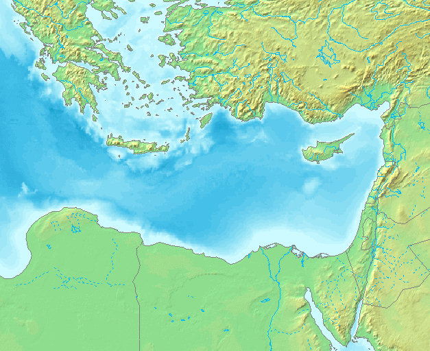 Map of the Levantine Sea | |
 Levantine Sea | |
 The location of the Levantine Sea | |
| Location | Mediterranean |
| Coordinates | 34°N 34°E |
| Type | Sea |
| Basin countries | Greece, Turkey, Egypt, Syria, Lebanon, Israel, Palestine, Jordan, Cyprus, Iraq, A large number of countries included in drainage basins for inflow rivers |
| Surface area | 320,000 km2 (120,000 sq mi) |

Geography
The Levantine Sea is bordered by Turkey in the north and north-east corner, Syria, Lebanon, Israel, and Palestine in the east, Egypt in the south, and the Aegean Sea in the northwest. Where it is used as a term its western border is amorphous, hence Mediterranean is more commonly used. The open western border to the next part of the Mediterranean (the Libyan Sea) is defined as a line from headland Ras al-Helal in Libya to Gavdos, south of the western half of Crete.
The largest island in its subset of water is Cyprus. The greatest depth of 4,384 m (14,383 ft) is found in the Pliny Trench, about 80 km (50 mi) south of Crete. The Levantine Sea covers 320,000 km2 (120,000 sq mi).
The northern part of the Levantine Sea between Cyprus and Turkey can be further specified as the Cilician Sea, a term more arcane. Also in the north are two large bays, the Gulf of İskenderun (to the northeast) and the Gulf of Antalya (to the northwest).
Basins

The Leviathan gas field is quite central in the south-eastern corner, the Levantine Basin.[3][4]
To the west of the Levantine Deep Marine Basin is the Nile Delta Basin, followed by the Herodotus Basin, 130,000 km2 (50,000 sq mi) large and up to 3,200 m (10,500 ft) deep,[5] which – at a possible age of 340 million years – is believed to be the oldest known ocean crust worldwide.[6]
Ecology
The Suez Canal was completed in 1869, linking the Levantine Sea to the Red Sea – and mainly for large vessels. The Red Sea sits a little higher than the Eastern Mediterranean, so the canal is an intermittent tidal strait discharging water into the Mediterranean. The Bitter Lakes – hypersaline natural lakes, interacting with the canal – were a bar to migration of Red Sea species northward for many decades, but as their salinity has virtually equalized with that of the Red Sea, the barrier to migration was removed, and plants and animals from the Red Sea have begun to colonize the eastern Mediterranean. This is the Lessepsian migration, after Ferdinand de Lesseps, the chief engineer of the canal.
Most of the river discharge is from the Nile. Since the Aswan High Dam sits across the river in the 1960s it has facilitated the multiplication of Egyptian agriculture and population. It has reduced, to the sea, the flow of freshwater, mountainous minerals in the silt, and the distance traveled by silt (before this, borne by floodwater). This makes the sea slightly saltier and nutrient-poorer than before. This has decimated the morning sardine litorine haul in nets but favored many Red Sea species.
See also
- Eastern Mediterranean
- Levant
References
- Gacic, Miroslav; Bensi, Manuel (2020-12-10). Ocean Exchange and Circulation. MDPI. p. 7. ISBN 978-3-03936-152-6.
It is modified flowing eastward, passes the Sicily Channel and the Ionian Sea and enters the easternmost part of the Mediterranean, the Levantine Sea.
- Ashwarya, Sujata (2019-05-03). Israel's Mediterranean Gas: Domestic Governance, Economic Impact, and Strategic Implications. Taylor & Francis. p. 2. ISBN 978-0-429-53623-6.
The Levantine Sea is the easternmost part of the Mediterranean that includes the territorial waters of Israel, Gaza Strip, Lebanon, and Syria.
- "Archived copy" (PDF). Archived from the original (PDF) on 2011-07-17. Retrieved 2011-07-17.
{{cite web}}: CS1 maint: archived copy as title (link) - "Archived copy" (PDF). Archived from the original (PDF) on 2011-07-18. Retrieved 2011-02-12.
{{cite web}}: CS1 maint: archived copy as title (link) - Hydrocarbon Potential in Herodotus Basin, Eastern Mediterranean, p. 2
- Ben-Gurion University of the Negev: Three Hundred Million Years Under the Sea
Further reading
- Kubin, Elisabeth; Poulain, Pierre-Marie; Mauri, Elena; Menna, Milena; Notarstefano, Giulio. 2019. "Levantine Intermediate and Levantine Deep Water Formation: An Argo Float Study from 2001 to 2017" Water 11, no. 9: 1781. https://doi.org/10.3390/w11091781
- Özsoy, E. and H. Güngör (1993). The Northern Levantine Sea Circulation Based on Combined Analysis of CTD and ADCP Data, In: P. Brasseur (editor), Data Assimilation: Tools for Modelling the Ocean in a Global Change Perspective, NATO ASI Series, Springer-Verlag, Berlin.
- Sur, H. İ., Özsoy, E., and Ü. Ünlüata, (1992). Simultaneous Deep and Intermediate Depth Convection in the Northern Levantine Sea, Winter 1992, Ocean.
External links
![]() Media related to Levantine Sea at Wikimedia Commons
Media related to Levantine Sea at Wikimedia Commons
African seas | |
|---|---|
| Oceans and seas |
|
| Gulfs and bays |
|
| Straits |
|
| Historical seas | |
Authority control | |
|---|---|
| General |
|
| National libraries | |
| Other |
|
На других языках
- [en] Levantine Sea
[es] Mar Levantino
El mar Levantino o mar de Levante (en árabe, شرق البحر الأبيض المتوسط; en hebreo, מזרח תיכון; en turco, Doğu Akdeniz; en griego, Της Ανατολικής Μεσογείου, Tis Anatolikís Mesogeíou) es un mar marginal del mar Mediterráneo situado en su parte oriental, que baña las costas de Egipto, Líbano, Chipre, Israel, Palestina, Siria y Turquía.[ru] Левантийское море
Леванти́йское мо́ре (греч. Θάλασσα του Λεβάντε, тур. Levanten Denizi, араб. اَلْبَحرْ الشامي, ивр. יַם לבנטיני) — название восточной части Средиземного моря.Другой контент может иметь иную лицензию. Перед использованием материалов сайта WikiSort.org внимательно изучите правила лицензирования конкретных элементов наполнения сайта.
WikiSort.org - проект по пересортировке и дополнению контента Википедии