geo.wikisort.org - River
The Suez Canal (Egyptian Arabic: قَنَاةُ ٱلسُّوَيْسِ, Qanāt el Sewes) is an artificial sea-level waterway in Egypt, connecting the Mediterranean Sea to the Red Sea through the Isthmus of Suez and dividing Africa and Asia. The 193.30 km (120.11 mi) long canal is a popular trade route between Europe and Asia.
| Suez Canal | |
|---|---|
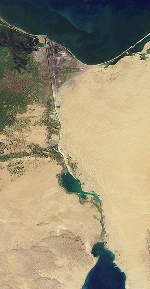 The Suez Canal from space, showing the Great Bitter Lake at the centre (before the 2015 expansion) | |
| Coordinates | 30°42′18″N 32°20′39″E |
| Specifications | |
| Length | 193.3 km (120.1 miles) |
| Maximum boat beam | 77.5 m (254 ft 3 in) |
| Maximum boat draft | 20.1 m (66 ft) |
| Locks | None |
| Navigation authority | Suez Canal Authority |
| History | |
| Construction began | 25 September 1859 |
| Date completed | 17 November 1869 |
| Geography | |
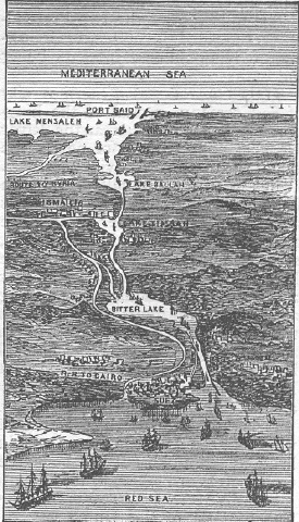
| Start point | Port Said |
| End point | Suez Port |
In 1858, Ferdinand de Lesseps formed the Suez Canal Company for the express purpose of building the canal. Construction of the canal lasted from 1859 to 1869. The canal officially opened on 17 November 1869. It offers vessels a direct route between the North Atlantic and northern Indian oceans via the Mediterranean Sea and the Red Sea, avoiding the South Atlantic and southern Indian oceans and reducing the journey distance from the Arabian Sea to London by approximately 8,900 kilometres (5,500 mi), or 10 days at 20 knots (37 km/h; 23 mph) to 8 days at 24 knots (44 km/h; 28 mph).[1] The canal extends from the northern terminus of Port Said to the southern terminus of Port Tewfik at the city of Suez. In 2021, more than 20,600 vessels traversed the canal (an average of 56 per day).[2]
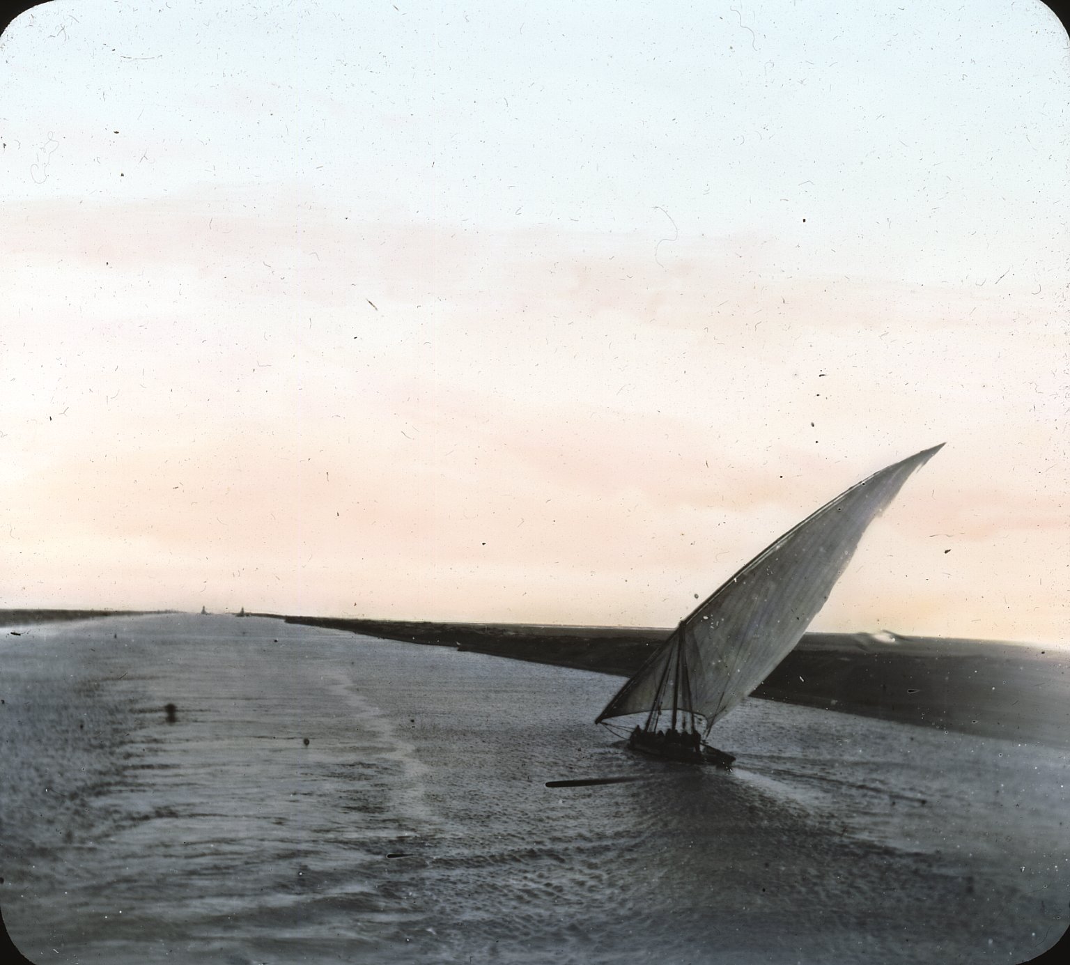
The original canal featured a single-lane waterway with passing locations in the Ballah Bypass and the Great Bitter Lake.[3] It contained, according to Alois Negrelli's plans, no lock systems, with seawater flowing freely through it. In general, the water in the canal north of the Bitter Lakes flows north in winter and south in summer. South of the lakes, the current changes with the tide at Suez.[4]
The canal was the property of the Egyptian government, but European shareholders, mostly British and French, owned the concessionary company which operated it until July 1956, when President Gamal Abdel Nasser nationalised it—an event which led to the Suez Crisis of October–November 1956.[5] The canal is operated and maintained by the state-owned Suez Canal Authority[6] (SCA) of Egypt. Under the Convention of Constantinople, it may be used "in time of war as in time of peace, by every vessel of commerce or of war, without distinction of flag."[7] Nevertheless, the canal has played an important military strategic role as a naval short-cut and choke point. Navies with coastlines and bases on both the Mediterranean Sea and the Red Sea (Egypt and Israel) have a particular interest in the Suez Canal. After Egypt closed the Suez Canal at the beginning of the Six-Day War on 5 June 1967, the canal remained closed for precisely eight years, reopening on 5 June 1975.[8]
The Egyptian government launched construction in 2014 to expand and widen the Ballah Bypass for 35 km (22 mi) to speed up the canal's transit time. The expansion intended to nearly double the capacity of the Suez Canal, from 49 to 97 ships per day.[9] At a cost of LE 59.4 billion(US$9 billion), this project was funded with interest bearing investment certificates issued exclusively to Egyptian entities and individuals.
The Suez Canal Authority officially opened the new side channel in 2016. This side channel, at the northern side of the east extension of the Suez Canal, serves the East Terminal for berthing and unberthing vessels from the terminal. As the East Container Terminal is located on the Canal itself, before the construction of the new side channel it was not possible to berth or unberth vessels at the terminal while a convoy was running.[10]
Precursors

Ancient west–east canals were built to facilitate travel from the Nile to the Red Sea.[11][12][13] One smaller canal is believed to have been constructed under the auspices of Senusret II[14] or Ramesses II.[11][12][13] Another canal, probably incorporating a portion of the first,[11][12] was constructed under the reign of Necho II, but the only fully functional canal was engineered and completed by Darius I.[11][12][13]
Second millennium BC
James Henry Breasted attributes the earliest known attempt to construct a canal to the first cataract, near Aswan, to the Sixth Dynasty of Egypt and its completion to Senusret III of the Twelfth Dynasty of Egypt.[15]
The legendary Sesostris (likely either Pharaoh Senusret II or Senusret III of the Twelfth Dynasty of Egypt[14][15]) may have constructed the ancient canal, the Canal of the Pharaohs, joining the Nile with the Red Sea (BC 1897–1839), when an irrigation channel was constructed around BC 1848 that was navigable during the flood season, leading into a dry river valley east of the Nile River Delta named Wadi Tumilat.[16] (It is said that in ancient times the Red Sea reached northward to the Bitter Lakes[11][12] and Lake Timsah.[17])
In his Meteorology, Aristotle (384–322 BC) wrote:
One of their kings tried to make a canal to it (for it would have been of no little advantage to them for the whole region to have become navigable; Sesostris is said to have been the first of the ancient kings to try), but he found that the sea was higher than the land. So he first, and Darius afterwards, stopped making the canal, lest the sea should mix with the river water and spoil it.[19]
Strabo wrote that Sesostris started to build a canal, and Pliny the Elder (AD 23/24–79)wrote:
165. Next comes the Tyro tribe and, the harbour of the Daneoi, from which Sesostris, king of Egypt, intended to carry a ship-canal to where the Nile flows into what is known as the Delta; this is a distance of over 60 miles [100 km]. Later the Persian king Darius had the same idea, and yet again Ptolemy II, who made a trench 100 feet [30 m] wide, 30 feet [9 m] deep and about 35 miles [55 km] long, as far as the Bitter Lakes.[20]
In the 20th century, the northward extension of the later Darius I canal was discovered, extending from Lake Timsah to the Ballah Lakes.[21] This was dated to the Middle Kingdom of Egypt by extrapolating the dates of ancient sites along its course.[21]
The reliefs of the Punt expedition under Hatshepsut, BC 1470, depict seagoing vessels carrying the expeditionary force returning from Punt. This suggests that a navigable link existed between the Red Sea and the Nile.[22] Recent excavations in Wadi Gawasis may indicate that Egypt's maritime trade started from the Red Sea and did not require a canal.[citation needed] Evidence seems to indicate its existence by the 13th century BC during the time of Ramesses II.[11][23][24][25]
Canals dug by Necho, Darius I and Ptolemy
Remnants of an ancient west–east canal through the ancient Egyptian cities of Bubastis, Pi-Ramesses, and Pithom were discovered by Napoleon Bonaparte and his engineers and cartographers in 1799.[12][26][27][28][29]
According to the Histories of the Greek historian Herodotus,[30] about BC 600, Necho II undertook to dig a west–east canal through the Wadi Tumilat between Bubastis and Heroopolis,[12] and perhaps continued it to the Heroopolite Gulf and the Red Sea.[11] Regardless, Necho is reported as having never completed his project.[11][12]
Herodotus was told that 120,000 men perished in this undertaking, but this figure is doubtless exaggerated.[31] According to Pliny the Elder, Necho's extension to the canal was about 92 kilometres (57 statute miles),[12] equal to the total distance between Bubastis and the Great Bitter Lake, allowing for winding through valleys.[12] The length that Herodotus tells, of over 1000 stadia (i.e., over 183 kilometres or 114 miles), must be understood to include the entire distance between the Nile and the Red Sea[12] at that time.
With Necho's death, work was discontinued. Herodotus tells that the reason the project was abandoned was because of a warning received from an oracle that others would benefit from its successful completion.[12][32] Necho's war with Nebuchadnezzar II most probably prevented the canal's continuation.
Necho's project was completed by Darius I of Persia, who ruled over Ancient Egypt after it had been conquered by his predecessor Cambyses II.[33] It may be that by Darius's time a natural[12] waterway passage which had existed[11] between the Heroopolite Gulf and the Red Sea[34] in the vicinity of the Egyptian town of Shaluf[12] (alt. Chalouf[35] or Shaloof), located just south of the Great Bitter Lake,[12] had become so blocked[11] with silt[12] that Darius needed to clear it out so as to allow navigation[12] once again. According to Herodotus, Darius's canal was wide enough that two triremes could pass each other with oars extended, and required four days to traverse. Darius commemorated his achievement with a number of granite stelae that he set up on the Nile bank, including one near Kabret, and a further one a few kilometres north of Suez. Darius the Great's Suez Inscriptions read:[36]
King Darius says: I am a Persian; setting out from Persia I conquered Egypt. I ordered to dig this canal from the river that is called Nile and flows in Egypt, to the sea that begins in Persia. Therefore, when this canal had been dug as I had ordered, ships went from Egypt through this canal to Persia, as I had intended
— Darius Inscription
The canal left the Nile at Bubastis. An inscription[37] on a pillar at Pithom records that in 270 or 269 BCE, it was again reopened, by Ptolemy II Philadelphus. In Arsinoe,[12] Ptolemy constructed a navigable lock, with sluices, at the Heroopolite Gulf of the Red Sea,[34] which allowed the passage of vessels but prevented salt water from the Red Sea from mingling with the fresh water in the canal.[38]
In the second half of the 19th century, French cartographers discovered the remnants of an ancient north–south canal past the east side of Lake Timsah and ending near the north end of the Great Bitter Lake.[39] This proved to be the canal made by Darius I, as his stele commemorating its construction was found at the site. (This ancient, second canal may have followed a course along the shoreline of the Red Sea when it once extended north to Lake Timsah.[39])
Receding Red Sea and the dwindling Nile
The Red Sea is believed by some historians to have gradually receded over the centuries, its coastline slowly moving southward away from Lake Timsah[17] and the Great Bitter Lake.[11][12] Coupled with persistent accumulations of Nile silt, maintenance and repair of Ptolemy's canal became increasingly cumbersome over each passing century.
Two hundred years after the construction of Ptolemy's canal, Cleopatra seems to have had no west–east waterway passage,[11][12] because the Pelusiac branch of the Nile, which fed Ptolemy's west–east canal, had by that time dwindled, being choked with silt.[11][12] In support of this contention one can note that in 31 BCE, during a reversal of fortune in Mark Antony's and Cleopatra's war against Octavian, she attempted to escape Egypt with her fleet by raising the ships out of the Mediterranean and dragging them across the isthmus of Suez to the Red Sea. Then, according to Plutarch, the Arabs of Petra attacked and burned the first wave of these ships and Cleopatra abandoned the effort.[40] (Modern historians, however, maintain that her ships were burned by the enemy forces of Malichus I.)[41][42]
Old Cairo to the Red Sea
By the 8th century, a navigable canal existed between Old Cairo and the Red Sea,[11][12] but accounts vary as to who ordered its construction – either Trajan or 'Amr ibn al-'As, or Umar.[11][12] This canal was reportedly linked to the River Nile at Old Cairo[12] and ended near modern Suez.[11][43] A geography treatise De Mensura Orbis Terrae written by the Irish monk Dicuil (born late 8th century) reports a conversation with another monk, Fidelis, who had sailed on the canal from the Nile to the Red Sea during a pilgrimage to the Holy Land in the first half of the 8th century[44]
The Abbasid Caliph al-Mansur is said to have ordered this canal closed in 767 to prevent supplies from reaching Arabian detractors.[11][12]
Repair by al-Ḥākim
Al-Hakim bi-Amr Allah is claimed to have repaired the Cairo to Red Sea passageway, but only briefly, circa 1000 CE, as it soon "became choked with sand".[12] However, parts of this canal still continued to fill in during the Nile's annual inundations.[11][12]
Conception by Venice
The successful 1488 navigation of southern Africa by Bartolomeu Dias opened a direct maritime trading route to India and the Spice Islands, and forever changed the balance of Mediterranean trade. One of the most prominent losers in the new order, as former middlemen, was the former spice trading center of Venice.
Venetian leaders, driven to desperation, contemplated digging a waterway between the Red Sea and the Nile – anticipating the Suez Canal by almost 400 years – to bring the luxury trade flooding to their doors again. But this remained a dream.
— Colin Thubron, Seafarers: The Venetians (1980), p. 102
Despite entering negotiations with Egypt's ruling Mamelukes, the Venetian plan to build the canal was quickly put to rest by the Ottoman conquest of Egypt in 1517, led by Sultan Selim I.[45]
Ottoman attempts
During the 16th century, the Ottoman Grand Vizier Sokollu Mehmed Pasha attempted to construct a canal connecting the Red Sea and the Mediterranean. This was motivated by a desire to connect Constantinople to the pilgrimage and trade routes of the Indian Ocean, as well as by strategic concerns—as the European presence in the Indian Ocean was growing, Ottoman mercantile and strategic interests were increasingly challenged, and the Sublime Porte was increasingly pressed to assert its position. A navigable canal would allow the Ottoman Navy to connect its Red Sea, Black Sea, and Mediterranean fleets. However, this project was deemed too expensive, and was never completed.[46][47]
Napoleon's discovery of an ancient canal
During the French campaign in Egypt and Syria in late 1798, Napoleon expressed interest in finding the remnants of an ancient waterway passage. This culminated in a cadre of archaeologists, scientists, cartographers and engineers scouring northern Egypt.[48][49] Their findings, recorded in the Description de l'Égypte, include detailed maps that depict the discovery of an ancient canal extending northward from the Red Sea and then westward toward the Nile.[48][50]
Later, Napoleon, who became the French Emperor in 1804, contemplated the construction of a north–south canal to connect the Mediterranean with the Red Sea. But the plan was abandoned because it incorrectly concluded that the waterway would require locks to operate, the construction of which would be costly and time-consuming. The belief in the need for locks was based on the erroneous belief that the Red Sea was 8.5 m (28 ft) higher than the Mediterranean. This was the result of using fragmentary survey measurements taken in wartime during Napoleon's Egyptian Expedition.[51]
As late as 1861, the unnavigable ancient route discovered by Napoleon from Bubastis to the Red Sea still channelled water as far east as Kassassin.[12]
History of the Suez Canal
Interim period

Despite the construction challenges that could have been the result of the alleged difference in sea levels, the idea of finding a shorter route to the east remained alive. In 1830, General Francis Chesney submitted a report to the British government that stated that there was no difference in elevation and that the Suez Canal was feasible, but his report received no further attention. Lieutenant Waghorn established his "Overland Route", which transported post and passengers to India via Egypt.[52][53]
Linant de Bellefonds, a French explorer of Egypt, became chief engineer of Egypt's Public Works. In addition to his normal duties, he surveyed the Isthmus of Suez and made plans for the Suez Canal. French Saint-Simonianists showed an interest in the canal and in 1833, Barthélemy Prosper Enfantin tried to draw Muhammad Ali's attention to the canal but was unsuccessful. Alois Negrelli, the Italian-Austrian railroad pioneer, became interested in the idea in 1836.
In 1846, Prosper Enfantin's Société d'Études du Canal de Suez invited a number of experts, among them Robert Stephenson, Negrelli and Paul-Adrien Bourdaloue to study the feasibility of the Suez Canal (with the assistance of Linant de Bellefonds). Bourdaloue's survey of the isthmus was the first generally accepted evidence that there was no practical difference in altitude between the two seas. Britain, however, feared that a canal open to everyone might interfere with its India trade and therefore preferred a connection by train from Alexandria via Cairo to Suez, which Stephenson eventually built.
Construction by the Suez Canal Company
Preparations (1854–1858)

In 1854 and 1856, Ferdinand de Lesseps obtained a concession from Sa'id Pasha, the Khedive of Egypt and Sudan, to create a company to construct a canal open to ships of all nations. The company was to operate the canal for 99 years from its opening. De Lesseps had used his friendly relationship with Sa'id, which he had developed while he was a French diplomat in the 1830s. As stipulated in the concessions, de Lesseps convened the International Commission for the piercing of the isthmus of Suez (Commission Internationale pour le percement de l'isthme de Suez) consisting of 13 experts from seven countries, among them John Robinson McClean, later President of the Institution of Civil Engineers in London, and again Negrelli, to examine the plans developed by Linant de Bellefonds, and to advise on the feasibility of and the best route for the canal. After surveys and analyses in Egypt and discussions in Paris on various aspects of the canal, where many of Negrelli's ideas prevailed, the commission produced a unanimous report in December 1856 containing a detailed description of the canal complete with plans and profiles.[54] The Suez Canal Company (Compagnie universelle du canal maritime de Suez) came into being on 15 December 1858.

The British government had opposed the project from the outset to its completion. The British, who controlled both the Cape route and the Overland route to India and the Far East, favored the status quo, given that a canal might disrupt their commercial and maritime supremacy. Lord Palmerston, the project's most unwavering foe, confessed in the mid-1850s the real motive behind his opposition: that Britain's commercial and maritime relations would be overthrown by the opening of a new route, open to all nations, and thus deprive his country of its present exclusive advantages.[55] As one of the diplomatic moves against the project when it nevertheless went ahead, it disapproved of the use of "forced labour" for construction of the canal. Involuntary labour on the project ceased, and the viceroy condemned the corvée, halting the project.[56]
Initially international opinion was sceptical and Suez Canal Company shares did not sell well overseas. Britain, Austria, and Russia did not buy a significant number of shares. With assistance from the Cattaui banking family, and their relationship with James de Rothschild of the French House of Rothschild bonds and shares were successfully promoted in France and other parts of Europe.[57] All French shares were quickly sold in France. A contemporary British skeptic claimed "One thing is sure... our local merchant community doesn't pay practical attention at all to this grand work, and it is legitimate to doubt that the canal's receipts... could ever be sufficient to recover its maintenance fee. It will never become a large ship's accessible way in any case."[58]
Construction (1859–1869)
Work started on the shore of the future Port Said on 25 April 1859.
The excavation took some 10 years, with forced labour (corvée) being employed until 1864 to dig out the canal.[59] Some sources estimate that over 30,000 people were working on the canal at any given period, that more than 1.5 million people from various countries were employed,[51][60] and that tens of thousands of labourers died, many of them from cholera and similar epidemics.
Estimates of the number of deaths vary widely with Gamal Abdel Nasser citing 120,000 deaths upon nationalisation of the canal in a 26 July 1956 speech and the company's chief medical officer reporting no higher than 2.49 deaths per thousand in 1866.[52] Doubling these estimates with a generous assumption of 50,000 working staff per year over 11 years would put a conservative estimate at fewer than 3,000 deaths. More closely relying on the limited reported data of the time, the number would be fewer than 1,000.[52]
Inauguration (17 November 1869)
The canal opened under French control in November 1869. The opening ceremonies began at Port Said on the evening of 15 November, with illuminations, fireworks, and a banquet on the yacht of the Khedive Isma'il Pasha of Egypt and Sudan. The royal guests arrived the following morning: the Emperor Franz Joseph I, the French Empress Eugenie in the Imperial yacht L'Aigle, the Crown Prince of Prussia, and Prince Louis of Hesse.[61] Other international guests included the American natural historian H. W. Harkness.[62] In the afternoon there were blessings of the canal with both Muslim and Christian ceremonies, a temporary mosque and church having been built side by side on the beach. In the evening there were more illuminations and fireworks.[61]
On the morning of 17 November, a procession of ships entered the canal, headed by the L'Aigle. Among the ships following was HMS Newport, captained by George Nares, which surveyed the canal on behalf of the Admiralty a few months later.[63] The Newport was involved in an incident that demonstrated some of the problems with the canal. There were suggestions that the depth of parts of the canal at the time of the inauguration were not as great as promised, and that the deepest part of the channel was not always clear, leading to a risk of grounding.[61][64][65] The first day of the passage ended at Lake Timsah, 76 kilometres (41 nmi) south of Port Said. The French ship Péluse anchored close to the entrance, then swung around and grounded, the ship and its hawser blocking the way into the lake. The following ships had to anchor in the canal itself until the Péluse was hauled clear the next morning, making it difficult for them to join that night's celebration in Ismailia. Except for the Newport: Nares sent out a boat to carry out soundings, and was able to manoeuver around the Péluse to enter the lake and anchor there for the night.[66][67]
Ismailia was the scene of more celebrations the following day, including a military "march past", illuminations and fireworks, and a ball at the Governor's Palace. The convoy set off again on the morning of 19 November, for the remainder of the trip to Suez.[61] After Suez, many of the participants headed for Cairo, and then to the Pyramids, where a new road had been built for the occasion.[51]
An Anchor Line ship, the S.S. Dido, became the first to pass through the Canal from South to North.[68][69]
Initial difficulties (1869–1871)
Although numerous technical, political, and financial problems had been overcome, the final cost was more than double the original estimate.
The Khedive, in particular, was able to overcome initial reservations held by both British and French creditors by enlisting the help of the Sursock family, whose deep connections proved invaluable in securing much international support for the project.[70][71]
After the opening, the Suez Canal Company was in financial difficulties. The remaining works were completed only in 1871, and traffic was below expectations in the first two years. De Lesseps therefore tried to increase revenues by interpreting the kind of net ton referred to in the second concession (tonneau de capacité) as meaning a ship's cargo capacity and not only the theoretical net tonnage of the "Moorsom System" introduced in Britain by the Merchant Shipping Act in 1854. The ensuing commercial and diplomatic activities resulted in the International Commission of Constantinople establishing a specific kind of net tonnage and settling the question of tariffs in its protocol of 18 December 1873.[72] This was the origin of the Suez Canal Net Tonnage and the Suez Canal Special Tonnage Certificate, both of which are still in use today.
Growth and reorganisation

The canal had an immediate and dramatic effect on world trade. Combined with the American transcontinental railroad completed six months earlier, it allowed the world to be circled in record time. It played an important role in increasing European colonization of Africa. The construction of the canal was one of the reasons for the Panic of 1873 in Great Britain, because goods from the Far East had, until then, been carried in sailing vessels around the Cape of Good Hope and stored in British warehouses. An inability to pay his bank debts led Said Pasha's successor, Isma'il Pasha, in 1875 to sell his 44% share in the canal for £4,000,000 ($19.2 million), equivalent to £432 million to £456 million ($540 million to $570 million) in 2019, to the government of the United Kingdom.[73] French shareholders still held the majority.[74] Local unrest caused the British to invade in 1882 and take full control, although nominally Egypt remained part of the Ottoman Empire. The British representative from 1883 to 1907 was Evelyn Baring, 1st Earl of Cromer, who reorganized and modernized the government and suppressed rebellions and corruption, thereby facilitating increased traffic on the canal.[75]
The European Mediterranean countries in particular benefited economically from the Suez Canal, as they now had much faster connections to Asia and East Africa than the North and West European maritime trading nations such as Great Britain, the Netherlands or Germany. The biggest beneficiary in the Mediterranean was Austria-Hungary, which had participated in the planning and construction of the canal. The largest Austrian maritime trading company, Österreichischer Lloyd, experienced rapid expansion after the canal was completed, as did the port city of Trieste, then an Austrian possession. The company was a partner in the Compagnie Universelle du Canal de Suez, whose vice-president was the Lloyd co-founder Pasquale Revoltella.[76][77][78][79][80]
The Convention of Constantinople in 1888 declared the canal a neutral zone under the protection of the British, who had occupied Egypt and Sudan at the request of Khedive Tewfiq to suppress the Urabi Revolt against his rule. The revolt went on from 1879 to 1882. The British defended the strategically important passage against a major Ottoman attack in 1915, during the First World War.[81] Under the Anglo-Egyptian Treaty of 1936, the UK retained control over the canal. With outbreak of World War II the canal was again strategically important; Italo-German attempts to capture it were repulsed during the North Africa Campaign, which ensured the canal remained closed to Axis shipping.
Suez Crisis
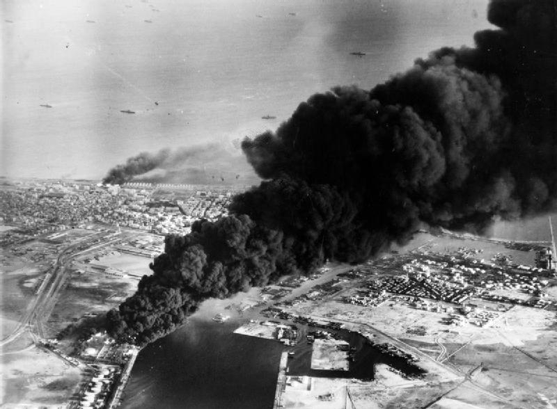
In 1951 Egypt repudiated the 1936 treaty with Great Britain. In October 1954 the UK tentatively agreed to remove its troops from the Canal Zone. Because of Egyptian overtures towards the Soviet Union, both the United Kingdom and the United States withdrew their pledge to financially support construction of the Aswan Dam. Egyptian President Gamal Abdel Nasser responded by nationalising the canal on 26 July 1956[82] and transferring it to the Suez Canal Authority, intending to finance the dam project using revenue from the canal. On the same day that the canal was nationalised Nasser also closed the Straits of Tiran to all Israeli ships.[83] This led to the Suez Crisis in which the UK, France, and Israel invaded Egypt. According to the pre-agreed war plans under the Protocol of Sèvres, Israel invaded the Sinai Peninsula on 29 October, forcing Egypt to engage them militarily, and allowing the Anglo-French partnership to declare the resultant fighting a threat to stability in the Middle East and enter the war – officially to separate the two forces but in reality to regain the Canal and bring down the Nasser government.[84][85][86]
To save the British from what he thought was a disastrous action and to stop the war from a possible escalation, Canadian Secretary of State for External Affairs Lester B. Pearson proposed the creation of the first United Nations peacekeeping force to ensure access to the canal for all and an Israeli withdrawal from the Sinai Peninsula. On 4 November 1956, a majority at the United Nations voted for Pearson's peacekeeping resolution, which mandated the UN peacekeepers to stay in Sinai unless both Egypt and Israel agreed to their withdrawal. The United States backed this proposal by putting pressure on the British government through the selling of sterling, which would cause it to depreciate. Britain then called a ceasefire, and later agreed to withdraw its troops by the end of the year. Pearson was later awarded the Nobel Peace Prize. As a result of damage and ships sunk under orders from Nasser the canal was closed until April 1957, when it was cleared with UN assistance.[87] A UN force (UNEF) was established to maintain the free navigability of the canal, and peace in the Sinai Peninsula.
Arab–Israeli wars of 1967 and 1973
Prior to the 1967 war, Egypt had repeatedly closed the canal to Israeli shipping as a defensive measure, refusing to open the canal in 1949 and during the 1956 Suez Crisis. Egypt did so despite UN Security Council resolutions from 1949 and 1951 urging it not to, claiming that hostilities had ended with the 1949 armistice agreement.[88]
On 16 May 1967, when Nasser ordered the UNEF peacekeeping forces out of the Sinai Peninsula, including the Suez Canal area, Egyptian troops were sent into Sinai to take their place. Israel protested Nasser's order to close the Straits of Tiran to Israeli trade on 21 May, the same year. This halted Israeli shipping between the port of Eilat and the Red Sea.[89]
After the 1967 Six-Day War, Israeli forces occupied the Sinai Peninsula, including the entire east bank of the Suez Canal. In the following years the tensions between Egypt and Israeli intensified and from March 1969 until August 1970, a war of attrition took place as the then Egyptian president, Gamal Abdel Nasser, tried to retake the territories occupied by Israel during the conflict. The fighting ceased after the death of Nasser in 1970. After this conflict there were no changes in the distribution of territory, but the underlying tensions persisted.[90]
Unwilling to allow the Israelis to use the canal, Egypt immediately imposed a blockade which closed the canal to all shipping immediately after the beginning of the Six-Day War. The canal remained blocked for eight years. There was no anticipation of this event and consequently fifteen cargo ships, known as the "Yellow Fleet", were trapped in the canal, and remained there until its reopening in 1975.[91]
On 6 October 1973, during the Yom Kippur War, the canal was the scene of the Operation Badr, in which the Egyptian military crossed the Suez Canal into Israeli-occupied Sinai Peninsula. Much wreckage from this conflict remains visible along the canal's edges.[92] Arab oil exporters, sympathetic to Egypt, pushed OPEC to raise the price of crude oil by around 17 percent and eventually imposed an embargo against the United States and other Israeli allies.[89]
Mine clearing operations (1974–75)
After the Yom Kippur War, the United States initiated Operation Nimbus Moon. The amphibious assault ship USS Inchon (LPH-12) was sent to the Canal, carrying 12 RH-53D minesweeping helicopters of Helicopter Mine Countermeasures Squadron 12. These partly cleared the canal between May and December 1974. She was relieved by the LST USS Barnstable County (LST1197). The British Royal Navy initiated Operation Rheostat and Task Group 65.2 provided for Operation Rheostat One[93] (six months in 1974), the minehunters HMS Maxton, HMS Bossington, and HMS Wilton, the Fleet Clearance Diving Team (FCDT)[94] and HMS Abdiel, a practice minelayer/MCMV support ship; and for Operation Rheostat Two[95] (six months in 1975) the minehunters HMS Hubberston and HMS Sheraton, and HMS Abdiel. When the Canal Clearance Operations were completed, the canal and its lakes were considered 99% clear of mines. The canal was then reopened by Egyptian President Anwar Sadat aboard an Egyptian destroyer, which led the first convoy northbound to Port Said in 1975,[96] at his side stood the Iranian Crown Prince Reza Pahlavi.[97]
UN presence
The UNEF mandate expired in 1979. Despite the efforts of the United States, Israel, Egypt, and others to obtain an extension of the UN role in observing the peace between Israel and Egypt, as called for under the Egypt–Israel peace treaty of 1979, the mandate could not be extended because of the veto by the Soviet Union in the UN Security Council, at the request of Syria. Accordingly, negotiations for a new observer force in the Sinai produced the Multinational Force and Observers (MFO), stationed in Sinai in 1981 in coordination with a phased Israeli withdrawal. The MFO remains active under agreements between the United States, Israel, Egypt, and other nations.[98]
Bypass expansion

In 2014, months after taking office as President of Egypt, Abdel Fattah el-Sisi ordered the expansion of the Ballah Bypass from 61 metres (200 ft) wide to 312 metres (1,024 ft) wide for 35 kilometres (22 mi). The project was called the New Suez Canal, as it allows ships to transit the canal in both directions simultaneously.[99][100] The project cost more than LE 59.4 billion (US$9 billion) and was completed within a year. Sisi declared the expanded channel open to business in a ceremony on 6 August 2015.[5]
2021 obstruction
On 23 March 2021, at around 05:40 UTC (07:40 local time),[101] the Suez Canal was blocked in both directions by the ultra-large Evergreen G-class container ship Ever Given.[102] The ship, operated by Evergreen Marine, was en route from Malaysia to the Netherlands when it ran aground after strong winds allegedly blew the ship off course.[101] Upon running aground, Ever Given turned sideways, completely blocking the canal.[103][101] Although part of the length of the canal is paralleled by an older narrower channel which can be used to bypass obstructions, this incident occurred south of that area, in a section of the canal where there is only one channel.[104] The site was located at 30.01574°N 32.57918°E.
When the incident began, many economists and trade experts commented on the effects of the obstruction if not resolved quickly, citing how important the Suez was to global trade; the incident was likely to drastically affect the global economy because of the trapped goods scheduled to go through the canal. Among those goods, oil shipments were the most affected in the immediate aftermath, due to a significant number still blocked with no other way to reach their destination.[105][106] Referring to the European and American market, a few maritime experts have disputed the prediction of a drastic effect on trade, saying this "really isn’t a substantial transit route for crude" according to Marshall Steeves, energy markets analyst at IHS Markit, and "there are existing stocks" according to Camille Egloff of Boston Consulting Group and alternative sources of supply, noting that traffic only slowed down and that it might only have impacted sectors with existing shortages (such as the semiconductor industry).[107][108] The International Chamber of Shipping (ICS) estimates that up to $3 billion worth of cargo passes through the Suez Canal every day.[109]
It was said the blockage would have an impact on cargo schedules around the world. Shipping companies were also considering whether to divert their ships along the much longer route around the Cape of Good Hope. The first container ship to do so was Ever Given's sister ship, Ever Greet.[110]
The ship was re-floated on 29 March.[111][112] Within a few hours, cargo traffic resumed, slowly resolving the backlog of around 450 ships.[113] The first ship to successfully pass through the canal after the Ever Given's recovery was the YM Wish, a Hong Kong-based cargo ship.[114]
On 2 April 2021, Usama Rabie, chairman of the Suez Canal Authority of Egypt, said that the damage caused by the blockage of the canal could reach about $1 billion. Rabie also revealed that after the Suez Canal resumed navigation, as of noon on 31 March 285 cargo ships had passed through the canal smoothly. He said that the remaining 175 freighters waiting to pass through the canal would all pass by 2 April.[115]
After the incident, the Egyptian government announced that they would be widening the narrower parts of the canal.[116] On 9 September 2021, the canal was briefly blocked again by the MV Coral Crystal.[117] However, this ship was freed within 15 minutes, presenting minimal disruption to other convoys.
Timeline
This section contains a list of miscellaneous information. (March 2021) |
- 1798: Napoleon Bonaparte commanded an expedition to Egypt with the intent of having “the Isthmus of Suez cut through” and assuring “the free and exclusive possession of the Red Sea to the French Republic”.[118]
- 1799: Bonaparte ordered the first feasibility study of the isthmus of Suez, which was carried out by Jacques-Marie Lepère[119] (1763-1841). see also Commission des Sciences et des Arts
- 1809: The findings of Lepère's survey, published in “Description de l’Égypte”, incorrectly reported an alleged 10-metre (32 feet 6 inches) difference in sea levels and a high cost, so the project was put on hold.[120][121][122]
- 1833: Saint Simonians popularized the idea of constructing the canal. Prosper Enfantin, the leader of a sect of Saint Simonians, met with Ferdinand de Lesseps to conduct further surveys for the Suez Canal project.[123]
- 1847: A second survey which included Robert Stephenson, Adrien Bourdaloue and Alois Negrelli, discovered that the first analysis was incorrect. It is possible to build a direct link between the Mediterranean Sea and the Red Sea.[120]
- 30 November 1854: The former French consul in Cairo, Ferdinand Marie de Lesseps, obtained the first license for construction through an Act of Concession from Egypt's new viceroy, Said Pasha.[120][124]
- 15 December 1858: De Lesseps established the international company "Compagnie Universelle du Canal Maritime de Suez"; initially the majority was controlled by French private holders.[125]
- 25 April 1859: Construction officially started, with 20,000 fellahin forced to work.[126][127]
- 17 November 1869: Official opening of the Suez Canal. Empress Eugénie of France attended the opening ceremony and celebrations.[120][128][129]
- 1873: The International Commission of Constantinople established the Suez Canal Net Ton and the Suez Canal Special Tonnage Certificate [130]
- 1875: The British purchase nearly half of the Suez Canal company's stock.[131]
- 1882: British military forces invaded Egypt. The canal was still managed by the privately owned Suez Canal Company.[132]
- 29 October 1888: The Convention of Constantinople was signed. Its main purpose was to guarantee free passage to merchant ships and regulate the transit of military warships.[133]
- 26 January to 4 February 1915: the Raid on the Suez Canal occurred as the Ottoman Army attacked the Suez Canal which was under the protectorate of the British Empire.[134]
- 14 November 1936: Following a new treaty, Britain pulled out of Egypt, but established the 'Suez Canal Zone' under its control.
- 10 January 1950: Passenger tariffs are abolished.[135]
- 13 June 1956: Suez Canal Zone was restored to Egyptian sovereignty, following British withdrawal of about 90,000 troops and years of negotiations.[136]
- 26 July 1956: the Egypt president Nasser nationalised the Canal, previously under the control of a Franco-British company.[137]
- 29 October 1956: Israel proceeded with the invasion of the Egyptian portion of the Sinai, marking the beginning of the Suez Crisis.[137]
- 31 October 1956 to 24 April 1957: the canal was blocked to shipping as a consequence of the Suez Crisis, a conflict that led to an Israeli, French, and British occupation of the canal zone.
- 29 November 1956: Tripartite invasion is ended, the canal zone was restored to Egyptian control, following French and British withdrawal, and the landing of UNEF troops.
- 5 June 1967 to 10 June 1975: The canal was blocked by Egypt, following the war with Israel; it became the front line during the ensuing War of Attrition and the 1973 war, remaining closed to international shipping, until general agreement was reached.[90]
- 10 June 1967: Six Day War ends with the Israeli's capture of the Sinai.[92]
- March 1969 to August 1970: War of Attrition between Egypt and Israel ended in a draw.[90]
- 6 October 1973: Operation Badr took place; Egyptian and Syrian armies crossed the canal and occupied part of the Sinai under Israel's control.[138]
- 10 June 1975: The Suez Canal is re-opened for first time since the Arab-Israeli 1967 war.[138]
- 2004: The canal was closed for three days when the oil tanker Tropic Brilliance became stuck.[139]
- 1 January 2008: New rules of navigation passed by the Suez Canal Authority came into force together with an increase of fees for transit of about 7.1%.[140]
- 6 August 2015: The new canal extensions were opened which consisted in a deepening of the main Canal as well as a 35 km-wide side Canal.[141]
- 18 October 2017: OOCL Japan ran aground causing an obstruction which blocked the canal for a few hours.[142][143][139]
- 23 to 29 March 2021: Ever Given, a Panama-flagged container ship, ran aground and became stuck across the southern section of the canal. The blockage prevented movement through the canal, caused nearly $10 billion worth of disruptions in shipping traffic each day, and created a large traffic jam of ships on both sides.[144][145][146][147]
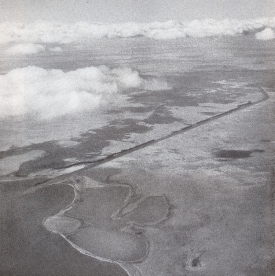
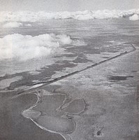 Suez Canal in February 1934. Air photograph taken by Swiss pilot and photographer Walter Mittelholzer.
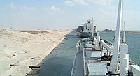
 USS America (CV-66), an American aircraft carrier in the Suez Canal
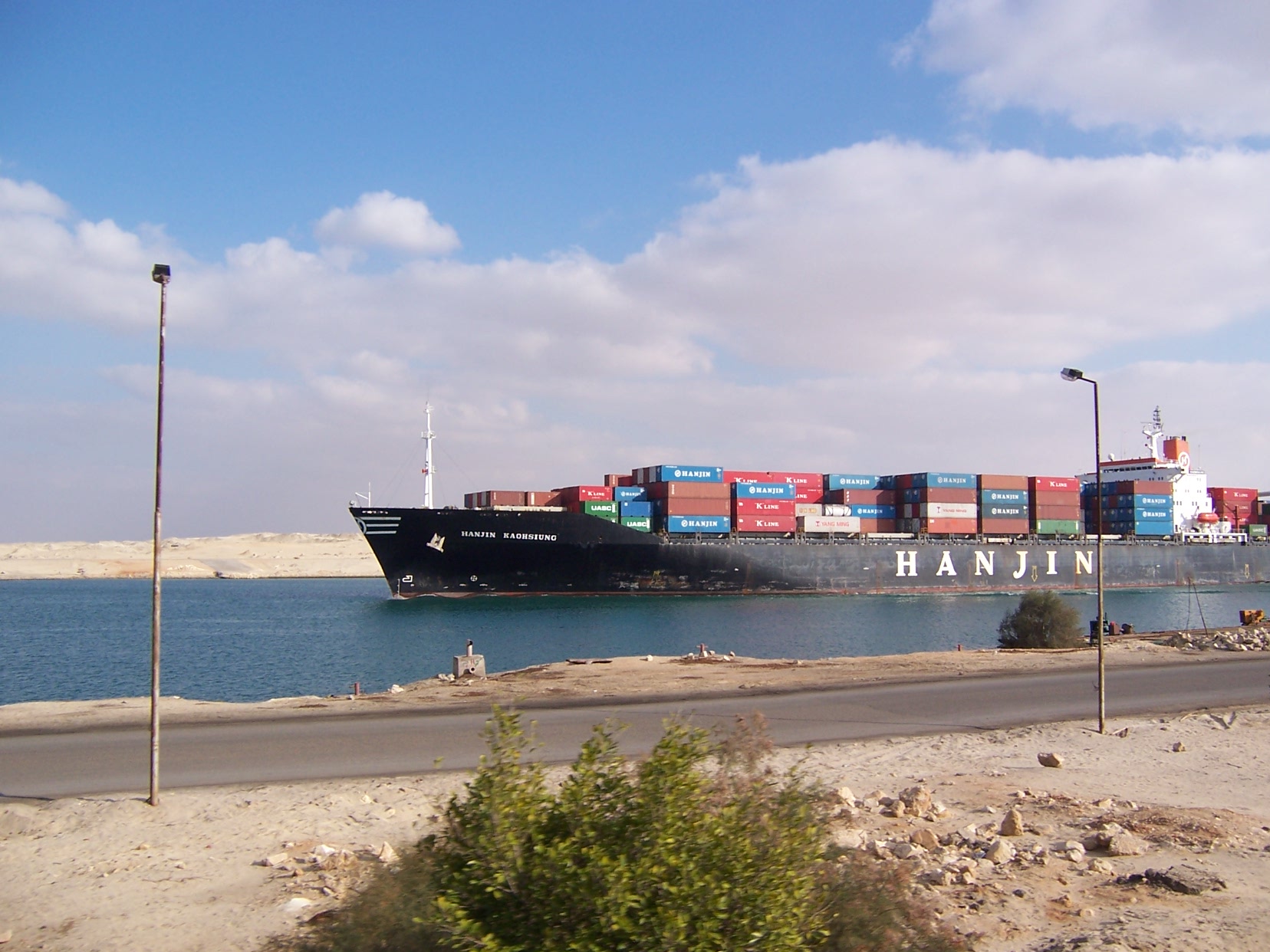
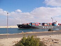 Container ship Hanjin Kaohsiung transiting the Suez Canal

Layout and operation
Suez Canal | ||||||||||||||||||||||||||||||||||||||||||||||||||||||||||||||||||||||||||||||||||||||||||||||||||||||||||||||||||||||||||||||||||||||||||||||||||||||||||||||||||||||||||||||||||||||||||||||||||||||||||||||||||||||||||||||||||||||||||||||||||||||||||||||||||
|---|---|---|---|---|---|---|---|---|---|---|---|---|---|---|---|---|---|---|---|---|---|---|---|---|---|---|---|---|---|---|---|---|---|---|---|---|---|---|---|---|---|---|---|---|---|---|---|---|---|---|---|---|---|---|---|---|---|---|---|---|---|---|---|---|---|---|---|---|---|---|---|---|---|---|---|---|---|---|---|---|---|---|---|---|---|---|---|---|---|---|---|---|---|---|---|---|---|---|---|---|---|---|---|---|---|---|---|---|---|---|---|---|---|---|---|---|---|---|---|---|---|---|---|---|---|---|---|---|---|---|---|---|---|---|---|---|---|---|---|---|---|---|---|---|---|---|---|---|---|---|---|---|---|---|---|---|---|---|---|---|---|---|---|---|---|---|---|---|---|---|---|---|---|---|---|---|---|---|---|---|---|---|---|---|---|---|---|---|---|---|---|---|---|---|---|---|---|---|---|---|---|---|---|---|---|---|---|---|---|---|---|---|---|---|---|---|---|---|---|---|---|---|---|---|---|---|---|---|---|---|---|---|---|---|---|---|---|---|---|---|---|---|---|---|---|---|---|---|---|---|---|---|---|---|---|---|---|---|
| ||||||||||||||||||||||||||||||||||||||||||||||||||||||||||||||||||||||||||||||||||||||||||||||||||||||||||||||||||||||||||||||||||||||||||||||||||||||||||||||||||||||||||||||||||||||||||||||||||||||||||||||||||||||||||||||||||||||||||||||||||||||||||||||||||
Legend | ||||||||||||||||||||||||||||||||||||||||||||||||||||||||||||||||||||||||||||||||||||||||||||||||||||||||||||||||||||||||||||||||||||||||||||||||||||||||||||||||||||||||||||||||||||||||||||||||||||||||||||||||||||||||||||||||||||||||||||||||||||||||||||||||||
| ||||||||||||||||||||||||||||||||||||||||||||||||||||||||||||||||||||||||||||||||||||||||||||||||||||||||||||||||||||||||||||||||||||||||||||||||||||||||||||||||||||||||||||||||||||||||||||||||||||||||||||||||||||||||||||||||||||||||||||||||||||||||||||||||||
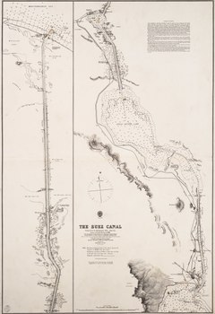
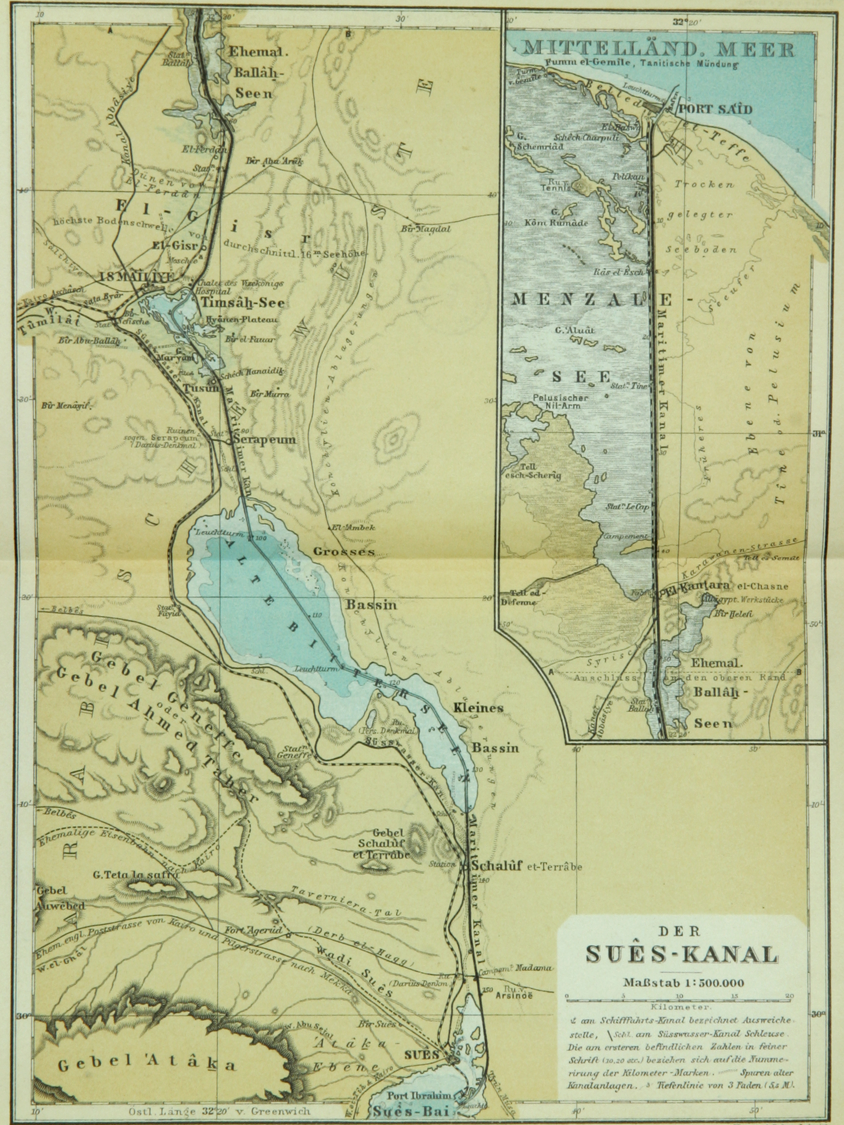
When built, the canal was 164 km (102 mi) long and 8 m (26 ft) deep. After several enlargements, it is 193.30 km (120+1⁄8 mi) long, 24 m (79 ft) deep and 205 metres (673 ft) wide.[149] It consists of the northern access channel of 22 km (14 mi), the canal itself of 162.25 km (100+7⁄8 mi) and the southern access channel of 9 km (5+1⁄2 mi).[150]
The so-called New Suez Canal, functional since 6 August 2015,[151] currently has a new parallel canal in the middle part, with its length over 35 km (22 mi). The current parameters of the Suez Canal, including both individual canals of the parallel section are: depth 23 to 24 metres (75 to 79 ft) and width at least 205 to 225 metres (673 to 738 ft) (that width measured at 11 metres (36 ft) of depth).[152]
Capacity
The canal allows passage of ships up to 20 m (66 ft) draft or 240,000 deadweight tons and up to a height of 68 m (223 ft) above water level and a maximum beam of 77.5 m (254 ft) under certain conditions.[153][149] The canal can handle more traffic and larger ships than the Panama Canal, as Suezmax dimensions are greater than both Panamax and New Panamax. Some supertankers are too large to traverse the canal. Others can offload part of their cargo onto a canal-owned ship to reduce their draft, transit, and reload at the other end of the canal. On 15 April 2021 Egyptian authorities announced that they would widen the southern section of the Suez Canal to improve the efficiency of the canal. The plan mainly covers about 30 kilometres (19 mi) from Suez to the Great Bitter Lake. It will be widened by 40 metres (130 ft)and the maximum depth will be increased from about 20 metres (66 ft) to about 22 metres (72 ft).[154]
Navigation
Ships approaching the canal from the sea are expected to radio the harbour when they are within 15 nautical miles (28 kilometres) of the Fairway Buoy near Port Said.[155] The canal has no locks because of the flat terrain, and the minor sea level difference between each end is inconsequential for shipping. As the canal has no sea surge gates, the ports at the ends would be subject to the sudden impact of tsunamis from the Mediterranean Sea and Red Sea, according to a 2012 article in the Journal of Coastal Research.[156]
There is one shipping lane with passing areas in Ballah-Bypass near El Qantara and in the Great Bitter Lake. On a typical day, three convoys transit the canal, two southbound and one northbound. The passage takes between 11 and 16 hours at a speed of around 8 knots (15 km/h; 9 mph). The low speed helps prevent erosion of the banks by ships' wakes.
By 1955, about two-thirds of Europe's oil passed through the canal. Around 8% of world sea trade is carried via the canal. In 2008, 21,415 vessels passed through the canal and the receipts totalled $5.381 billion,[153] with an average cost per ship of $251,000.
New Rules of Navigation came into force on 1 January 2008, passed by the board of directors of the Suez Canal Authority (SCA) to organise vessels' transit. The most important amendments include allowing vessels with 19-metre (62 ft) draught to pass, increasing the allowed breadth from 32 to 40 metres (105 to 131 ft) (following improvement operations), and imposing a fine on vessels using pilots from outside the SCA inside the canal boundaries without permission. The amendments allow vessels loaded with dangerous cargo (such as radioactive or flammable materials) to pass if they conform with the latest amendments provided by international conventions.
The SCA has the right to determine the number of tugs required to assist warships traversing the canal, to achieve the highest degree of safety during transit.[157]
 Ships moored at El Ballah during transit
 Predominant currents in the Mediterranean Sea for June


Operation
Before August 2015, the canal was too narrow for free two-way traffic, so ships had to pass in convoys and use bypasses. The bypasses were 78 km (48 mi) out of 193 km (120 mi) (40%). From north to south, they are Port Said bypass (entrances) 36.5 km (23 mi), Ballah bypass & anchorage 9 km (6 mi), Timsah bypass 5 km (3 mi), and the Deversoir bypass (northern end of the Great Bitter Lake) 27.5 km (17 mi). The bypasses were completed in 1980.
Typically, it would take a ship 12 to 16 hours to transit the canal. The canal's 24-hour capacity was about 76 standard ships.[158]
In August 2014, Egypt chose a consortium that includes the Egyptian army and global engineering firm Dar Al-Handasah to develop an international industrial and logistics hub in the Suez Canal area,[159] and began the construction of a new canal section from 60 to 95 km (37 to 59 mi) combined with expansion and deep digging of the other 37 kilometres (23 mi) of the canal.[160] This will allow navigation in both directions simultaneously in the 72-kilometre-long (45 mi) central section of the canal. These extensions were formally opened on 6 August 2015 by President Al-Sisi.[9][161][162]
 Post-deepening, a capesize bulk carrier approaches the Friendship Bridge
 Northbound convoy waits in the Great Bitter Lake as southbound convoy passes, October 2014


Convoy sailing
Since the canal does not cater to unregulated two-way traffic, all ships transit in convoys on regular times, scheduled on a 24-hour basis. Each day, a single northbound convoy starts at 04:00 from Suez. At dual lane sections, the convoy uses the eastern route.[163][164][165] Synchronised with this convoy's passage is the southbound convoy. It starts at 03:30 from Port Said and so passes the Northbound convoy in the two-lane section.[clarification needed]
Canal crossings
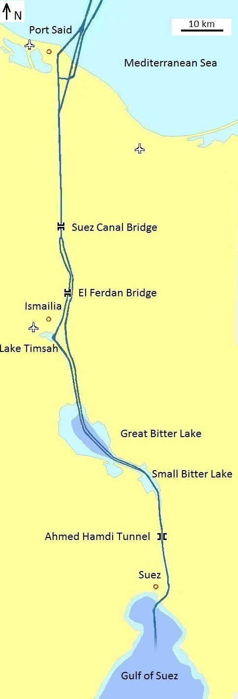
From north to south, the crossings are:
- The El Nasr pontoon bridge (31.2285°N 32.3042°E), connecting Port Said to Port Fuad. Opened in 2016, 420 m (1,380 ft) length.[166]
- The Abanoub Gerges pontoon bridge (30.8436°N 32.3168°E), 1.5 km (1 mi) north of the Suez Canal Bridge
- The Suez Canal Bridge (30.828248°N 32.317572°E), also called the Egyptian-Japanese Friendship Bridge, a high-level road bridge at El Qantara. In Arabic, al qantara means "arch". Opened in 2001, it has a 70-metre (230 ft) clearance over the canal and was built with assistance from the Japanese government and by Kajima.[167]
- El Ferdan Railway Bridge (30.657°N 32.334°E) 20 km (12 mi) north of Ismailia (30°35′N 32°16′E) was completed in 2001 and is the longest swing-span bridge in the world, with a span of 340 m (1100 ft). The previous bridge was destroyed in 1967 during the Arab-Israeli conflict. The current bridge is no longer functional due to the expansion of the Suez Canal, as the parallel shipping lane completed in 2015 just east of the bridge lacks a structure spanning it.
- The Ahmed el-Mansy pontoon bridge (30.6054°N 32.3254°E), a pair of pontoons bridging both channels
- The Taha Zaki Abdullah pontoon bridge (30.4729°N 32.3502°E), a pair of pontoons bridging both channels
- Pipelines taking fresh water under the canal to Sinai, about 57 km (35 mi) north of Suez, at 30°27.3′N 32°21.0′E.
- Ahmed Hamdi Tunnel (30°5′9″N 32°34′32″E) south of the Great Bitter Lake (30°20′N 32°23′E) was built in 1983. Because of leakage problems, a new water-tight tunnel[168] was built inside the old one from 1992 to 1995.
- The Ahmed Omar Shabrawy pontoon bridge (30.0453°N 32.5744°E)
- The Suez Canal overhead powerline crossing (29.996°N 32.583°E) was built in 1999.
A railway on the west bank runs parallel to the canal for its entire length.
The five pontoon bridges were opened between 2016 and 2019.[169] They are designed to be movable, and can be completely rotated against the banks of the canal to allow shipping through, or else individual sections can be moved to create a narrower channel.
Six new tunnels for cars and trains are also planned across the canal.[170] Currently the Ahmed Hamdi is the only tunnel connecting Suez to the Sinai.
Economic impact

Economically, after its completion, the Suez Canal benefited primarily the sea trading powers of the Mediterranean countries, which now had much faster connections to the Near and Far East than the North and West European sea trading nations such as Great Britain or Germany.[76][171] The main Habsburg trading port of Trieste with its direct connections to Central Europe experienced a meteoric rise at that time.[172][173]
The time saved in the 19th century for an assumed steamship trip to Bombay from Brindisi and Trieste was 37 days, from Genoa 32, from Marseille 31, from Bordeaux, Liverpool, London, Amsterdam and Hamburg 24 days. At that time, it was also necessary to consider whether the goods to be transported could bear the costly canal tariff. This led to a rapid growth of Mediterranean ports with their land routes to Central and Eastern Europe. According to today's information from the shipping companies, the route from Singapore to Rotterdam through the Suez Canal will be shortened by 6,000 kilometres (3,700 mi) and thus by nine days compared to the route around Africa. As a result, liner services between Asia and Europe save 44 percent CO2 (carbon dioxide) thanks to this shorter route. The Suez Canal has a correspondingly important role in the connection between East Africa and the Mediterranean region.[174][175][176]
In the 20th century, trade through the Suez Canal came to a standstill several times, due to the two world wars and the Suez Canal crisis. Many trade flows were also shifted away from the Mediterranean ports towards Northern European terminals, such as Hamburg and Rotterdam. Only after the end of the Cold War, the growth in European economic integration, the consideration of CO2 emission and the Chinese Silk Road Initiative, are Mediterranean ports such as Piraeus and Trieste again at the focus of growth and investment.[174][177][178][179][180]
Alternative routes
Before the canal's opening in 1869, goods were sometimes offloaded from ships and carried overland between the Mediterranean and the Red Sea.[181]
Cape Agulhas
The main alternative is around Cape Agulhas, the southernmost point of Africa, commonly referred to as the Cape of Good Hope route. This was the only sea route before the canal was constructed, and when the canal was closed. It is still the only route for ships that are too large for the canal. In the early 21st century, the Suez Canal has suffered from diminished traffic due to piracy in Somalia, with many shipping companies choosing to take the long route instead.[182][183] Between 2008 and 2010, it is estimated that the canal lost 10% of traffic due to the threat of piracy, and another 10% due to the financial crisis. An oil tanker going from Saudi Arabia to the United States has 4,345 km (2,700 mi) farther to go when taking the route south of Africa rather than the canal.[184]
Northern Sea Route

In recent years, the shrinking Arctic sea ice has made the Northern Sea Route feasible for commercial cargo ships between Europe and East Asia during a six-to-eight-week window in the summer months, shortening the voyage by thousands of kilometres compared to that through the Suez Canal. According to polar climate researchers, as the extent of the Arctic summer ice pack recedes the route will become passable without the help of icebreakers for a greater period each summer.[185][186]
The Bremen-based Beluga Group claimed in 2009 to be the first Western company to attempt using the Northern Sea Route without assistance from icebreakers, cutting 6,400 kilometres (4,000 mi) off the journey between Ulsan, Korea and Rotterdam, the Netherlands.[187]
Cape Horn
Sailing ships, such as the windjammers in the heyday of the Great Grain Race between Australia and Europe during the 1930s, often preferred the Cape Horn route when going to Europe, due to prevalent wind directions, even though it is slightly longer from Sydney to Europe this way than past Cape Agulhas.
Negev desert railway
In February 2012, Israel announced its intention to construct a railway between the Mediterranean and Eilat through the Negev desert to compete with the canal.[188] By 2019, the project had been indefinitely frozen.[189]
Environmental impact
The opening of the canal created the first salt-water passage between the Mediterranean Sea and the Red Sea. Although the Red Sea is about 1.2 m (4 ft) higher than the eastern Mediterranean,[190] the current between the Mediterranean and the middle of the canal at the Bitter Lakes flows north in winter and south in summer. The current south of the Bitter Lakes is tidal, varying with the tide at Suez.[4] The Bitter Lakes, which were hypersaline natural lakes, blocked the migration of Red Sea species into the Mediterranean for many decades, but as the salinity of the lakes gradually equalised with that of the Red Sea the barrier to migration was removed, and plants and animals from the Red Sea have begun to colonise the eastern Mediterranean.[citation needed]
The Red Sea is generally saltier and more nutrient-poor than the Atlantic, so the Red Sea species have advantages over Atlantic species in the less salty and nutrient-rich eastern Mediterranean. Accordingly, most Red Sea species invade the Mediterranean biota, and only few do the opposite. This migratory phenomenon is called Lessepsian migration (after Ferdinand de Lesseps) or "Erythrean invasion". Also impacting the eastern Mediterranean, starting in 1968, was the operation of Aswan High Dam across the Nile. While providing for increased human development, the project reduced the inflow of freshwater and ended all natural nutrient-rich silt entering the eastern Mediterranean at the Nile Delta. This provided less natural dilution of Mediterranean salinity and ended the higher levels of natural turbidity, additionally making conditions more like those in the Red Sea.[citation needed]
Invasive species originating from the Red Sea and introduced into the Mediterranean by the canal have become a major component of the Mediterranean ecosystem and have serious impacts on the ecology, endangering many local and endemic species. About 300 species from the Red Sea have been identified in the Mediterranean, and there are likely others yet to be identified. The Egyptian government's intent to enlarge the canal raised concerns from marine biologists, who feared that it would enhance the invasion of Red Sea species.[191]
Construction of the canal was preceded by cutting a small fresh-water canal called Sweet Water Canal from the Nile delta along Wadi Tumilat to the future canal, with a southern branch to Suez and a northern branch to Port Said. Completed in 1863, these brought fresh water to a previously arid area, initially for canal construction, and subsequently facilitating growth of agriculture and settlements along the canal.[192]
Suez Canal Economic Zone
The Suez Canal Economic Zone, sometimes shortened to SCZONE, describes the set of locations neighbouring the canal where customs rates have been reduced to zero in order to attract investment. The zone comprises over 461 km2 (178 sq mi) within the governorates of Port Said, Ismailia and Suez. Projects in the zone are collectively described as the Suez Canal Area Development Project (SCADP).[193][194]
The plan focuses on development of East Port Said and the port of Ain Sokhna, and hopes to extend to four more ports at West Port Said, El-Adabiya, Arish and El Tor.[195]
The zone incorporates the four "Qualifying Industrial Zones" at Port Said, Ismailia and Suez, a 1996 American initiative to encourage economic ties between Israel and its neighbours.[196]
See also
- Belt and Road Initiative
- Canal des Deux Mers
- Container transport
- Corinth Canal
- Istanbul Canal
- Maritime Silk Road
- Mediterranean–Dead Sea Canal
- New Imperialism
- New Suez Canal
- Panama Canal
- Red Sea–Dead Sea Water Conveyance
- 21st Century Maritime Silk Road
- Yellow Fleet
References
- "The Suez Canal – A vital shortcut for global commerce" (PDF). World Shipping Council. Archived (PDF) from the original on 22 April 2018. Retrieved 15 March 2019.
- "Number of ships passing through the Suez Canal from 1976 to 2021". Statista. 31 March 2022.
{{cite web}}: CS1 maint: url-status (link) - "Suez Canal Authority". Archived from the original on 13 June 2014. Retrieved 2 May 2010.
- Elaine Morgan; Stephen Davies (1995). The Red Sea Pilot. Imray Laurie Norie & Wilson. p. 266. ISBN 9780852885543.
- "Suez Crisis". History.com. A&E Television Networks. 9 November 2009. Archived from the original on 30 March 2019. Retrieved 17 April 2019.
- "SCA Overview". Suez Canal Authority. Archived from the original on 25 June 2019. Retrieved 25 July 2019.
- Constantinople Convention of the Suez Canal of 2 March 1888 still in force and specifically maintained in Nasser's Nationalization Act.
- Feyrer, James. "Distance, Trade, and Income – The 1967 to 1975 Closing of the Suez Canal as a Natural Experiment" (PDF). National Bureau of Economic Research. Archived (PDF) from the original on 11 February 2021. Retrieved 27 March 2021.
- "New Suez Canal project proposed by Egypt to boost trade". caironews.net. Archived from the original on 29 November 2014. Retrieved 7 August 2014.
- "Egypt opens East Port Said side channel for navigation". Xinhua. Archived from the original on 25 February 2016. Retrieved 12 March 2016.
- Chisholm, Hugh, ed. (1911). . Encyclopædia Britannica. Vol. 26 (11th ed.). Cambridge University Press. pp. 22–25.
- Rappoport, S. (Doctor of Philosophy, Basel). History of Egypt (undated, early 20th century), Volume 12, Part B, Chapter V: "The Waterways of Egypt", pp. 248–257. London: The Grolier Society.
- Hassan, F. A. & Tassie, G. J. Site location and history (2003). Kafr Hassan Dawood On-Line, Egyptian Cultural Heritage Organization Archived 16 April 2005 at the Wayback Machine. Retrieved 8 August 2008.
- Please refer to Sesostris#Modern research.
- J. H. Breasted, Ancient Records of Egypt, 1906. Volume One, pp. 290–292, §§642–648. Chicago: The University of Chicago Press.
- Fisher, William B.; Smith, Charles Gordon. "Suez Canal". Encyclopaedia Britannica. Archived from the original on 19 November 2016. Retrieved 24 May 2017.
- The Columbia Encyclopedia, Sixth Edition, s.v. "Suez Canal" Archived 14 February 2009 at the Wayback Machine. Retrieved 14 May 2008.
- "Meteorology (1.15)". Ebooks.adelaide.edu.au. 25 August 2010. Archived from the original on 11 October 2018. Retrieved 24 August 2011.
- The Elder Pliny and John Healey Natural History (6.33.165) Penguin Classics; Reprint edition (5 February 2004) ISBN 978-0-14-044413-1 p. 70 books.google.com Archived 24 April 2016 at the Wayback Machine
- Shea, William H. "A Date for the Recently Discovered Eastern Canal of Egypt", in Bulletin of the American Schools of Oriental Research, No. 226 (April 1977), pp. 31–38.
- Sanford (1938), p. 72; Garrison (1999), p. 36.
- Hess, Richard S. Rev. of Israel in Egypt: The Evidence for the Authenticity of the Exodus Tradition Archived 29 April 2005 at the Wayback Machine, by James K. Hoffmeier. The Denver Journal 1 (1 January 1998). Retrieved 14 May 2008.
- Hassan, Fekri A. Kafr Hassan Dawood On-line Archived 15 January 2010 at the Wayback Machine, 17 August 2003. Retrieved 14 May 2008.
- (in Spanish) Martínez Babon, Javier. "Consideraciones sobre la Marinay la Guerra durante el Egipto Faraónico" Archived 1 February 2012 at the Wayback Machine. Retrieved 14 May 2008.
- Descriptions de l'Égypte, Volume 11 (État Moderne) Archived 19 August 2020 at the Wayback Machine, containing Mémoire sur la communication de la mer des Indes à la Méditerranée par la mer Rouge et l'Isthme de Sueys, par M. J.M. Le Père, ingénieur en chef, inspecteur divisionnaire au corps impérial des ponts et chaussées, membre de l'Institut d'Égypte, pp. 21–186
- Their reports were published in Description de l'Égypte
- Montet, Pierre. Everyday Life in the Days of Ramesses The Great (1981), page 184. Philadelphia: University of Pennsylvania Press.
- Silver, Morris (6 April 1998), "5c. Evidence for Earlier Canals." Ancient Economies II Archived 21 October 2015 at the Wayback Machine. Retrieved 8 August 2008. Economics Department, City College of New York.
- Herodotus ii.158.
- "The figure '120,000' is doubtless exaggerated. Mehemet Ali lost only 10,000 in making the Mahmûdieh Canal (from the Nile to Alexandria)." remarked W. W. How and J. Wells, A Commentary on Herodotus.
- According to Herodotus, work on the project was "stayed by a prophetic utterance that he [Necho] was toiling beforehand for the barbarian. The Egyptians call all men of other languages barbarians." (Herodotus, eo. loc..)
- "Cambyses II – King of Persia". Encyclopaedia Britannica. Archived from the original on 13 December 2013. Retrieved 19 November 2013.
- Apparently, Ptolemy considered the Great Bitter Lake as a northern extension of the Red Sea, whereas Darius had not, because Arsinoe is located north of Shaluf. (See Naville, "Map of the Wadi Tumilat", referenced above.)
- Please refer to Darius the Great's Suez Inscriptions.
- Jona Lendering. "Darius' Suez Inscriptions". Livius.org. Archived from the original on 6 August 2020. Retrieved 21 April 2020.
- "Pithom Stele – translation of inscription". www.attalus.org. Archived from the original on 17 December 2014. Retrieved 17 December 2014.
- R. E. Gmirkin, "Berossus and Genesis, Manetho and Exodus: Hellenistic Histories and the Date of the Pentateuch", p. 236
- Carte hydrographique de l'Basse Egypte et d'une partie de l'Isthme de Suez (1855, 1882). Volume 87, page 803. Paris. See Archived 13 February 2009 at the Wayback Machine
- Plutarch, "Life of Antony," 69.
- Burstein, Stanley M. (2004), The Reign of Cleopatra, Westport, CT: Greenwood Press, ISBN 978-0-313-32527-4, p.31.
- Roller, Duane W. (2010), Cleopatra: a Biography, Oxford: Oxford University Press, ISBN 978-0-19-536553-5, p. 142.
- Petermann, A. Karte Der Bai Von Súes (1856). Nach der Engl. Aufnahme v. Comm. Mansell.
- Tuchman, Barbara Bible and Sword: How the British came to Palestine MacMillan, London (1987) ISBN 0-333-33414-0
- Starthern, P. (2013) "The Venetians" p. 175
- Ortega, Stephen (2012). "The Ottoman Age of Exploration". The Historian. 74 (1): 89.
- Rossi, N.; Rosand, David (2013). "Italian Renaissance Depictions of the Ottoman Sultan: Nuances in the Function of Early Modern Italian Portraiture". ProQuest.
- Hall, Linda. The Search for the Ancient Suez Canal. Kansas City, Missouri. Archived from the original on 14 February 2009.
- Please refer to Description de l'Égypte.
- Descriptions de l'Égypte, Volume 11 (État Moderne) Archived 19 August 2020 at the Wayback Machine, containing Mémoire sur la communication de la mer des Indes à la Méditerranée par la mer Rouge et l'Isthme de Sueys, par M. J.M. Le Père, ingénieur en chef, inspecteur divisionnaire au corps impérial des ponts et chaussées, membre de l'Institut d'Égypte, pp. 21–186
- Wilson 1939.
- Wison, page 31 https://archive.org/details/suezcanal032262mbp •Overland Route later known as the Steam ship route which was the connection from Suez to Cairo, then down the Nile to the Mahmoudieh Canal and to the Mediterranean port of Alexandria. Superseded by the Suez canal, it operated from 1830 to 1869 and from 1837 with steam ships in the Red sea. •Between 1.36 and 2.49 deaths per thousand per year cited by the companies chief medical officer, page 31. Thus 34,258x2.49 deaths per thousand x 11 years=938 (highest reported working staff x highest reported deaths per thousand x number of years under construction)
- Addison, Herbert (1 April 1958). "Thomas Waghorn and the overland route". Journal of the Royal Central Asian Society. 45 (2): 179–185. doi:10.1080/03068375808731637. ISSN 0035-8789. Archived from the original on 27 March 2021. Retrieved 24 March 2021.
- Percement de l'isthme de Suez. Rapport et Projet de la Commission Internationale. Documents Publiés par M. Ferdinand de Lesseps. Troisième série. Paris aux bureaux de l'Isthme de Suez, Journal de l'Union des deux Mers, et chez Henri Plon, Éditeur, 1856. On Google Books (french)
- Lord Kinross, Between Two Seas. The Creation of the Suez Canal, William Morrow & Company, Inc., New York, 1969, p. 87.[ISBN missing]
- Oster (2006)
- There is differing information on the exact amounts
- "(reported by German historian Uwe A. Oster)". Archived from the original on 19 August 2011.
- Headrick, Daniel R. (1981). The Tools of Empire : Technology and European Imperialism in the Nineteenth Century. Oxford University Press. pp. 151–153. ISBN 0-19-502831-7. OCLC 905456588.
- "Le canal de Suez – ARTE". Arte.tv. 13 August 2006. Archived from the original on 19 August 2011. Retrieved 24 August 2011.
- Russel, Alexander (1869). Egypt: The Opening of the Great Canal. Edinburgh: "Scotsman" Office.
- "Harvey Wilson Harkness". Zoe. 2 (1): 1–2. 1891. Archived from the original on 12 November 2020. Retrieved 12 November 2020.
- Ritchie, G.S. (1967). The Admiralty Chart. London: Hollis & Carter. pp. 317–319.
- Richards, G.H. (1869). "Suez Canal, with directions for is pilotage". Proceedings of the Royal Geographical Society of London. 14 (1): 75–78. doi:10.2307/1799610. JSTOR 1799610.
- Bateman, J.F. (1870). "Some Account of the Suez Canal, in a Letter to the President". Proceedings of the Royal Society of London. 18: 132–144. doi:10.1098/rspl.1869.0034. S2CID 178734036.
- "The Opening of the Suez Canal". Pall Mall Gazette (the paper's correspondent was on board HMS Newport). London. 30 November 1869. p. 11. Retrieved 5 October 2019.
- This incident appears to have been the basis for a myth that the Newport manoeuvered around the assembled yachts on the night of 16th/17 November, and beat the Aigle to be the first through the canal (see Talk)
- Glasgow Herald, 17 November 1903
- History of the Anchor Line 1852–1911. 1911. Glasgow, UK: John Horn, for Anchor Line.
- Kassir, Samir (2011) [2010]. Beirut. Translated by M. B. DeBevoise (1st ed.). Berkeley, Calif.: University of California Press. p. 127. ISBN 9780520271265. OCLC 1083962708. Archived from the original on 18 August 2020. Retrieved 25 July 2019.
- Fawaz, Leila Tarazi (1983). Merchants and Migrants in Nineteenth-Century Beirut. Harvard Middle Eastern Studies no. 18. p. 92. ISBN 9780674569256. OCLC 993333677. Archived from the original on 16 November 2015. Retrieved 25 July 2019.
- Protocol of the Commission (in Ffrench)
- (£1 in 1875 = £109–114; 2019 Historical Uk Inflation Rates and Calculator; UK Inflation (CPI) Calculator – What's the Cost)
- Hicks, Geoffrey (2012). "Disraeli, Derby and the Suez Canal, 1875: Some Myths Reassessed". History. 97 (2 (326)): 182–203. doi:10.1111/j.1468-229X.2012.00548.x. JSTOR 24429312.
- Tignor, Robert L. (1963). "Lord Cromer: Practitioner and Philosopher of Imperialism". Journal of British Studies. 2 (2): 142–159. doi:10.1086/385467. JSTOR 175255. S2CID 145087661.
- Mary Pelletier "A brief history of the Suez Canal" In: Apollo 3 July 2018.
- Hubert Bergmann "Selfmademan und Tycoon mit Weitblick: Pasquale Freiherr von Revoltella (German: Self-made man and tycoon with a vision: Pasquale Freiherr von Revoltella" In: Der Standard 25 June 2020.
- See: Pasquale Revoltella "Österreich's Betheiligung am Welthandel: Betrachtungen und Vorschläge" (2020).
- "German: How the Suez Canal changed the world in 150 years". 16 November 2019. Archived from the original on 11 January 2021. Retrieved 9 January 2021.
- "Pasquale Revoltella, l'imprenditore veneziano che rese grande la città di Trieste". Archived from the original on 27 March 2021. Retrieved 18 January 2021.
- First World War – Willmott, H.P. Dorling Kindersley, 2003, p.87
- "The Suez Canal formally opened to ships". stratscope.com. StratScope. Archived from the original on 20 September 2017. Retrieved 19 May 2017.
- "1956: Egypt seizes Suez Canal". BBC News. 26 July 1956. Archived from the original on 17 March 2007. Retrieved 17 December 2015.
- "The Dean Memorandum". The National Archives. Government of UK. Archived from the original on 7 December 2016. Retrieved 29 October 2020.
- Rhodes James, Robert. "Excerpt from 'Anthony Eden: A Biography'". The National Archives. Government of UK. Archived from the original on 7 December 2016. Retrieved 29 October 2020.
- Shlaim, Avi (1997). "The Protocol of Sèvres, 1956: Anatomy of a War Plot". International Affairs. 73 (3): 509–530. doi:10.2307/2624270. JSTOR 2624270. Archived from the original on 5 April 2018. Retrieved 29 October 2020.
- The Other Side of Suez (documentary) – 2003
- Khadduri, Majid (1968). "Closure of the Suez Canal to Israeli Shipping". Law and Contemporary Problems. 33 (1): 147–157. doi:10.2307/1190847. ISSN 0023-9186. JSTOR 1190847.
- Anderson, Betty S. (2016). A History of the Modern Middle East : Rulers, Rebels, and Rogues. Stanford, California: Stanford University Press. pp. 331–336.
- "War of Attrition | History, Combatants, & Facts | Britannica". www.britannica.com. Retrieved 17 May 2022.
- Feyrer, James. 2021. “Distance, Trade, and Income — the 1967 to 1975 Closing of the Suez Canal as a Natural Experiment.” Journal of Development Economics 153 (102708): 1–32.
- Dunstan, Simon (2003). The Yom Kippur War 1973: 2, the Sinai. London: Osprey. pp. 35–60.
- "Operationl Rheostat One – Royal Navy Minesweepers Arrive at Port Said to Help Clear the Suez Canal". www.iwm.org.uk. Archived from the original on 13 February 2016. Retrieved 22 October 2015.
- "Operation Rheostat One – Fleet Clearance Diving Team at Work on the Wreck of the Mecca". www.iwm.org.uk. Archived from the original on 13 February 2016. Retrieved 22 October 2015.
- "Operation Rheostat Two – The Suez Canal is Opened". www.iwm.org.uk. Archived from the original on 13 February 2016. Retrieved 22 October 2015.
- "Archived copy" (PDF). Archived (PDF) from the original on 8 December 2013. Retrieved 30 October 2009.
{{cite web}}: CS1 maint: archived copy as title (link) - "The Stars and Stripes". 7 June 1975. Archived from the original on 22 June 2015.
- (Multinational Force and Observers Archived 19 August 2006 at the Wayback Machine)
- Lakshmi, Aiswarya (17 July 2015). "Egypt Completes New Waterway in Suez Canal". MarineLink. Archived from the original on 20 July 2015. Retrieved 6 August 2015.
- "Egypt completes dredging for new waterway in Suez Canal". Al-Ahram. 16 July 2015. Archived from the original on 22 August 2015. Retrieved 6 August 2015.
- "Egypt's Suez Canal blocked by huge container ship". BBC News. 24 March 2021. Archived from the original on 23 March 2021. Retrieved 24 March 2021.
- Schkvarkin, Erofey (23 March 2021). "Mega container ship hard aground in Suez Canal". Maritime Bulletin. Archived from the original on 23 March 2021. Retrieved 23 March 2021.
- "Massive cargo ship becomes wedged, blocks Egypt's Suez Canal". AP News. 24 March 2021. Archived from the original on 24 March 2021. Retrieved 24 March 2021.
- "Suez Canal Stays Blocked Despite Efforts to Free Stuck Ship". Bloomberg.com. 24 March 2021. Retrieved 24 March 2021.
- "How will Suez Canal blockage impact global trade?". The Independent. 24 March 2021. Archived from the original on 27 March 2021. Retrieved 25 March 2021.
- "'Anything you see in the stores' could be affected by Canal logjam, shipping experts say". NBC News. Archived from the original on 25 March 2021. Retrieved 25 March 2021.
- "What are the consequences of Suez Canal incident?". RTÉ. 24 March 2021. Archived from the original on 25 March 2021. Retrieved 24 March 2021.
- Saefong, Myra P. "Why the blockage of the Suez Canal matters for oil prices". MarketWatch. Archived from the original on 26 March 2021. Retrieved 25 March 2021.
- "How That Massive Container Ship Stuck in the Suez Canal Is Already Costing the World Billions of Dollars". Archived from the original on 26 March 2021. Retrieved 26 March 2021.
- "Suez Canal: Ships stuck in 'traffic jam' as salvage efforts continue". BBC News. 26 March 2021. Archived from the original on 26 March 2021. Retrieved 26 March 2021.
- Wittels, Jack; El Wardany, Salma; Magdy, Mirette (29 March 2021). "Giant Vessel Is Now Afloat, Inchcape Says: Suez Update". www.bloomberg.com. Retrieved 29 March 2021.
- "March 29, 2021 Suez Canal ship news". CNN. 29 March 2021. Retrieved 30 March 2021.
- "vesselfinder.com". Retrieved 26 March 2021.
- Nagourney, Eric (29 March 2021). "With the Suez Canal Unblocked, the World's Commerce Resumes Its Course". The New York Times. ISSN 0362-4331. Retrieved 30 March 2021.
- "Chairman of the Suez Canal Authority: The damage caused by the blockage may reach 1 billion US dollars – News Update". 1 April 2021.
- "Plans for Suez Canal to be widened after Ever Given cargo ship drama". ABC News. 12 May 2021.
- "Ship Briefly Stranded in Suez Canal Before Being Freed". Bloomberg. 9 September 2021. Retrieved 10 September 2021.
- Schonfield, Hugh J. The Suez Canal. p. 28.
- Douglas Antony Farnie. 1969. East and West of Suez the Suez Canal in History 1854–1956. Oxford Clarendon Press. p.4
- "A brief history of the Suez Canal – how deep it is and more". The Independent. 25 March 2021. Archived from the original on 25 March 2021. Retrieved 25 March 2021.
- Wilson, Arnold T. 1939. The Suez Canal. Its Past, Present, and Future (2nd ed.). London, New York, Toronto: Oxford University Press. p. 37.
- Full text published at Gallica: Vol XI, p. 37-370
- Wilson, Arnold T. (1939). The Suez Canal. Its Past, Present, and Future (2nd ed.). London, New York, Toronto: Oxford University Press. p.7.
- Wilson, Arnold T. (1939). The Suez Canal. Its Past, Present, and Future (2nd ed.). London, New York, Toronto: Oxford University Press. p.42
- Schonfield, Hugh J. The Suez Canal. p. 44.
- "BBC – History – British History in depth: The Suez Crisis". www.bbc.co.uk. Retrieved 27 March 2021.
- "A CENTURY OF SUEZ: THE CONCESSION AND THE CONVENTION". The Manchester Guardian. 1956.
- "17 November 1869: Opening of the Suez Canal". MoneyWeek. Archived from the original on 3 December 2020. Retrieved 25 March 2021.
- "LATEST ELECTRIC NEWS". Lloyd's Illustrated Newspaper. 28 November 1869. Retrieved 17 May 2022.
- Wilson, Arnold T. 1939. The Suez Canal. Its Past, Present, and Future (2nd ed.). London, New York, Toronto: Oxford University Press. p. 225.
- Schonfield, Hugh J. The Suez Canal. p. 63.
- Frederick, Braun, Lindsay (1997). Points of similarity and divergence in the 1882 and 1956 British interventions in Egypt. Michigan State University. OCLC 1085688735.
- Farnie, Douglas Antony (1969). East and West of Suez the Suez Canal in History 1854–1956. Oxford Clarendon Press. p. 337.
- Erickson, Edward J. (2001). "Ordered to Die: A History of the Ottoman Army in the First World War". Contributions in Military Studies. Westport, Connecticut: Greenwood Press. no. 201.
- Farnie, Douglas Antony (1969). East and West of Suez the Suez Canal in History 1854–1956. Oxford Clarendon Press. p. 656.
- "The 1956 Suez Crisis" (PDF).
{{cite journal}}: Cite journal requires|journal=(help) - Parks Canada Agency, Government of Canada (21 April 2022). "Suez crisis and Louis-S.-St-Laurent – Louis S. St. Laurent National Historic Site". www.pc.gc.ca. Retrieved 17 May 2022.
- Jordan, Michael C. (1997). The 1973 Arab-Israeli War: Arab Policies, Strategies, and Campaigns.
- "Suez Canal Snarled by Giant Ship Choking Key Trade Route". Bloomberg.com. 23 March 2021. Archived from the original on 24 March 2021. Retrieved 25 March 2021.
- Daily News Egypt Authors (2008). "Suez Canal to Raise Fees in 2008". dailynewsegypt.com. Retrieved 17 May 2022.
- BBC News (2015). "Egypt Launches Suez Canal Expansion".
- "OOCL Megaship Runs Aground in Suez Canal". Port Technology International. Archived from the original on 19 November 2017. Retrieved 30 March 2021.
- "Suez Canal: Owner of cargo ship blocking waterway apologises". BBC News. 25 March 2021. Archived from the original on 25 March 2021. Retrieved 25 March 2021.
- "Cargo ship blocking Suez Canal could take weeks to move". CNBC. 24 March 2021. Archived from the original on 24 March 2021. Retrieved 25 March 2021.
- "Suez Canal blocked by stranded Evergreen boxship". 24 March 2021. Archived from the original on 24 March 2021. Retrieved 25 March 2021.
- Conklin, Audrey (25 March 2021). "Suez Canal could be blocked for weeks, with $10B in shipping traffic per day disrupted: reports". FOXBusiness. Archived from the original on 27 March 2021. Retrieved 25 March 2021.
- Yee, Vivian; Santora, Marc (29 March 2021). "Suez Canal Live Updates: The Ever Given Is Free, Clearing Way for Traffic to Resume". The New York Times. ISSN 0362-4331. Retrieved 29 March 2021.
- "New Suez Canal". Government of Egypt (Suez Canal Authority). Archived from the original on 12 August 2015.
- "Canal Characteristics". Suez Canal Authority. 2010. Archived from the original on 22 March 2009. Retrieved 2 April 2010.
- "Characteristics of the canal". Archived from the original on 9 March 2009.
- "Navigation Circular "The New Suez Canal" No 5/2015". Suez Canal Authority. Archived from the original on 21 August 2015. Retrieved 15 August 2015.
- ""Attached Charts" to Navigation Circular "The New Suez Canal" No 5/2015" (PDF). Suez Canal Authority. Archived from the original (PDF) on 24 August 2015. Retrieved 15 August 2015.
- Suez Canal Authority http://www.suezcanal.gov.eg Archived 13 June 2014 at the Wayback Machine
- "Egypt announced the widening of the Suez Canal, expected to be completed within two years – News Update". 12 May 2021. Archived from the original on 12 May 2021. Retrieved 12 May 2021.
- Suez Canal Authority. Arab Republic of Egypt. Ashraf Ragab. (August 2015). Navigation in Suez Canal Rules of Navigation and Passage Procedures in Suez Canal. p. 9. Suez Canal Authority website Retrieved 27 March 2021.
- Finkl, Charles W.; Pelinovsky, Efim; Cathcart, Richard B. (2012). "A Review of Potential Tsunami Impacts to the Suez Canal". Journal of Coastal Research. 283 (4): 745–759. Bibcode:2012EGUGA..14...76F. doi:10.2112/JCOASTRES-D-12A-00002.1. ISSN 0749-0208. S2CID 54644781.
- SC News
- "Traffic system". Egyptian Maritime Data Bank (EMDB). Archived from the original on 23 March 2013. Retrieved 8 February 2013.
- Saleh, Stephen Kalin and Yasmine (3 August 2014). "Egypt awards Suez hub project to consortium that includes army: sources". Reuters. Archived from the original on 8 August 2014. Retrieved 7 August 2014.
- "New Suez Canal". Archived from the original on 19 January 2017. Retrieved 13 June 2015.
- Kingsley, Patrick (5 August 2014). "Egypt to build new Suez canal". The Guardian. London. Archived from the original on 24 February 2021. Retrieved 16 December 2016.
- "Egypt launches Suez Canal expansion". BBC News. 6 August 2015. Archived from the original on 6 August 2015. Retrieved 7 August 2015.
- "Traffic system". Archived from the original on 29 July 2015. Retrieved 8 August 2015.
- "Navigation Circular 5/2015". Archived from the original on 21 August 2015. Retrieved 15 August 2015.
- "Navigation, Convoy System". Suez Canal Authority. Archived from the original on 24 July 2013. Retrieved 17 February 2013.
- "BV classes EL-NASR floating bridge across Suez Canal" (PDF). Inland Navigation newsletter – 35. Bureau Veritas.
- "Kajima History". Kajima. Archived from the original on 23 March 2014. Retrieved 23 March 2014.
- "Salt-Corroded Tunnel Undergoes Major Renovation". Kajima.co.jp. Archived from the original on 24 July 2011. Retrieved 24 August 2011.
- "President Al Sisi inaugurated mega development projects in Central Sinai and Ismailia| The Arab Contractors". arabcont.com.
- "Six tunnels under Suez Canal". Tunnelbuilder. 1 December 2014. Archived from the original on 2 August 2015. Retrieved 6 August 2015.
- Hans Reis "Der Suezkanal – die wichtigste von Menschen geschaffene Wasserstrasse wurde vor 150 Jahren gebaut und war oft umkämpft" In: Neue Zürcher Zeitung 17 November 2019
- "Wie der Suezkanal in 150 Jahren die Welt verändert hat (German: How the Suez Canal changed the world in 150 years)". 16 November 2019. Archived from the original on 11 January 2021. Retrieved 9 January 2021.
- Gabriella Pultrone "Trieste: New Challenges and Opportunities in the Relational Dynamics between City and Port" In: Méditerranée, 111|2008 pp. 129.
- Harry de Wilt: Is One Belt, One Road a China crisis for North Sea main ports? in World Cargo News, 17. December 2019.
- Alexandra Endres: Schifffahrt ist fürs Klima genau so schlimm wie Kohle in Die Zeit, 9. December 2019.
- Harry G. Broadman "Afrika´s Silk Road" (2007), p. 59.
- Marcus Hernig: Die Renaissance der Seidenstraße (2018), p. 112.
- Tobias Piller "Italien als Teil von Chinas neuer Seidenstraße" In: Frankfurter Allgemeine Zeitung 15 March 2019.
- "DW documentary examines China's grip on Europe". Deutsche Welle. 12 August 2020. Archived from the original on 5 January 2021. Retrieved 11 January 2021.
- "New Silk Road: Everything that belongs to the mega project (German)".
- Overland Mail by Thomas Fletcher Waghorn, Railway Alexandria – Cairo – Suez built by Robert Stephenson
- Liam Stack, Arab countries meet to tackle Somali pirate threat Archived 25 January 2011 at the Wayback Machine – The Christian Science Monitor (21 November 2008).
- Louis Wasser, Somali piracy costs Suez Canal business Archived 12 January 2018 at the Wayback Machine, San Francisco Chronicle (29 April 2009).
- Bowden, Anna; et al. (December 2010). The Economic Cost of Maritime Piracy (PDF) (Report). One Earth Future Working Paper. p. 13. Archived from the original (PDF) on 29 June 2012. Retrieved 26 February 2011.
- "The Final Frontier: The Northern Sea Route". doi:10.1016/j.jtrangeo.2011.03.003. Archived from the original on 26 May 2011. Retrieved 28 May 2011.
{{cite journal}}: Cite journal requires|journal=(help) - "Bye pirates, hello Northeast Passage". AsianCorrespondent.com. 3 January 2010. Archived from the original on 9 August 2011. Retrieved 29 May 2011.
- "German vessels ready for the Northern Sea Route". BarentsObserver.com. 5 August 2009. Archived from the original on 6 January 2011. Retrieved 21 September 2009.
- "Iisrael ehitab Vahemere ja Punase mere vahele raudtee(Israel is building a railway between the Mediterranean and the Red Sea" (in Estonian). E24.ee. 5 February 2012. Archived from the original on 30 April 2014. Retrieved 25 November 2020.
- Barket, Amiram (28 January 2019). "Millions squandered on unrealistic projects". Globes. Rishon Le-Zion, Israel. Archived from the original on 6 August 2020. Retrieved 25 November 2020.
- Madl, Pierre (1999). Essay about the phenomenon of Lessepsian Migration Archived 31 July 2016 at the Wayback Machine, Colloquial Meeting of Marine Biology I, Salzburg, April 1999 (revised in Nov. 2001).
- Galil and Zenetos (2002)
- Britannica (2007)
- "Suez Canal Economic Zone". GAFI. Ministry of Investment, Egypt. 6 January 2016. Archived from the original on 27 April 2018. Retrieved 10 May 2018.
- "Egypt aims to attract $30 bln in investment in Suez Canal Zone within 5 years: Investment minister". Ahram Online. 25 July 2017. Archived from the original on 11 May 2018. Retrieved 10 May 2018.
- Abdel-Razek, Sherine (4 August 2015). "Canal corridor developments". Al Ahram Weekly. Archived from the original on 11 May 2018. Retrieved 10 May 2018.
- "Qualifying Industrial Zones". American Chamber of Commerce in Egypt. March 2018. Archived from the original on 23 March 2019. Retrieved 10 May 2018.
References
- Britannica (2007) "Suez Canal", in: The new Encyclopædia Britannica, 15th ed., 28, Chicago, Ill. ; London : Encyclopædia Britannica, ISBN 1-59339-292-3
- Farnie, D.A. East and West of Suez: Suez Canal in History, 1854–1956, a stanmdard scholarly history; 870 pp
- Galil, B.S. and Zenetos, A. (2002). "A sea change: exotics in the eastern Mediterranean Sea", in: Leppäkoski, E., Gollasch, S. and Olenin, S. (eds), Invasive aquatic species of Europe : distribution, impacts, and management, Dordrecht ; Boston : Kluwer Academic, ISBN 1-4020-0837-6, pp. 325–336
- Garrison, Ervan G. (1999) A history of engineering and technology : artful methods, 2nd ed., Boca Raton, Fla. ; London : CRC Press, ISBN 0-8493-9810-X
- Hallberg, Charles W. The Suez Canal: Its History and Diplomatic Importance (1931), a standard scholarly history; 440 pp; online Archived 20 July 2018 at the Wayback Machine
- Karabell, Zachary (2003) Parting the Desert: The Creation of the Suez Canal, Knopf, ISBN 978-0-375-40883-0
- Oster, Uwe (2006) Le fabuleux destin des inventions : le canal de Suez, TV documentary produced by ZDF and directed by Axel Engstfeld (Germany)
- Rathbone, William (1882). . London: Chapman and Hall, Limited.
- Sanford, Eva Matthews (1938) The Mediterranean world in ancient times, Ronald series in history, New York : The Ronald Press Company, 618 p.
- Pudney, John. Suez; De Lesseps' Canal. New York: Praeger, 1969. [ISBN missing]
- Wilson, Arnold T. (1939). The Suez Canal. Its Past, Present, and Future (2nd ed.). London, New York, Toronto: Oxford University Press.
External links
- Suez Canal Authority
- Darius the Great's Suez Inscriptions
- Suez Canal on OpenStreetMap
- Encyclopedia of the Orient: Suez Canal Archived 25 September 2018 at the Wayback Machine
- Entrance of the Suez Canal – 1882
- Suez Canal Container Terminal at Port Said
- Bibliography on Water Resources and International Law Peace Palace Library
- 3min video of sailing the 163km on YouTube, including the new section
- American Society of Civil Engineers – Suez Canal
- Suez Canal map by Strommer, 19th century. Eran Laor Cartographic Collection, The National Library of Israel. Historic Cities Research Project.
- Images of container ship Ever Given aground in Suez Canal BBC News
- Explained: The Whole Scenario Of Suez Canal. How Would It Have Impacted The Trade If It Persisted Longer? – Inventiva
| Authorities |
| | |||||
|---|---|---|---|---|---|---|---|
| Cities and ports |
| ||||||
| Infrastructure |
| ||||||
| Marine life |
| ||||||
| History |
| ||||||
| |||||||||||
| |||||||||||
| |||||||||||
| |||||||||||
| |||||||||||
| |||||||||||
Authority control | |
|---|---|
| National libraries | |
| Other | |
На других языках
[de] Suezkanal
30.70532.344166666667- [en] Suez Canal
[it] Canale di Suez
Il canale di Suez (in arabo: قناة السويس, Qanāt al-Suways) è un alveo artificiale navigabile situato in Egitto, a ovest della penisola del Sinai, tra Porto Said (Bûr Sa'îd) sul mar Mediterraneo e Suez (al-Suways) sul Mar Rosso.[ru] Суэцкий канал
Суэ́цкий кана́л (араб. قناة السويس, Канат эс-Сувайс[1]) — бесшлюзовый судоходный канал в Египте, соединяющий Средиземное и Красное моря. Зона канала считается условной границей между двумя материками, Африкой и Евразией. Кратчайший водный путь между Индийским океаном и акваторией Средиземного моря Атлантического океана: после строительства канала судам больше не нужно огибать Африку и морской путь сократился на 8 тыс. км. Суэцкий канал был открыт для судоходства 17 ноября 1869 года. Главные порты: Порт-Саид и Суэц[2].Другой контент может иметь иную лицензию. Перед использованием материалов сайта WikiSort.org внимательно изучите правила лицензирования конкретных элементов наполнения сайта.
WikiSort.org - проект по пересортировке и дополнению контента Википедии