geo.wikisort.org - Island
The Snares Islands / Tini Heke,[1] known colloquially as The Snares, is a group of uninhabited islands lying about 200 km south of New Zealand's South Island and to the south-southwest of Stewart Island / Rakiura. The Snares consist of the main North East Island and the smaller Broughton Island as well as the Western Chain Islands some 5 km (3.1 mi) to the west-southwest. Collectively, the Snares have a total land area of 3.5 km2 (1.4 sq mi).[2]
 The Snares Islands seen from the northeast, with Broughton Island on the left and Dapton Rocks on the right | |
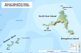 Map of the Snares Islands / Tini Heke | |
 Snares Islands / Tini Heke Location of the Snares Islands / Tini Heke in the Pacific Ocean | |
| Geography | |
|---|---|
| Coordinates | 48°01′S 166°32′E |
| Area | 3.5 km2 (1.4 sq mi) |
| Highest elevation | 130 m (430 ft) |
| Administration | |
New Zealand | |
| Demographics | |
| Population | Uninhabited (2013) |
The islands are listed with the New Zealand Outlying Islands. The islands are an immediate part of New Zealand, not part of any region or district, but instead Area Outside Territorial Authority, like all the other outlying islands except the Solander Islands.
History
The island group was first sighted by Europeans on 23 November 1791 independently by the two ships HMS Discovery under Captain George Vancouver, and HMS Chatham, commanded by Lieutenant William R. Broughton, both of the Vancouver Expedition. Vancouver named the islands "The Snares" because he considered them a shipping hazard; an islet east of the Western Chain bears the name Vancouver Rock, and the second largest island is named after Broughton.[citation needed]
In contrast to Vancouver, Broughton proposed the name "Knight's Island".[3]
The islands were already known to the Māori, who called one of the larger islands Te Taniwha ("The sea-monster"). Unlike other subantarctic islands that were greatly affected by the whaling and sealing industry in the 19th century, the Snares remain one of the last pristine areas in New Zealand.
The Ngai Tahu Claims Settlement Act 1998 officially altered the name to "Snares Islands/Tini Heke" – one of many such changes under the Ngāi Tahu Treaty settlement.[4]

Geography
The main island of the Snares group, North East Island, as its name suggests, lies at the northeastern corner of the group. It has roughly the shape of a triangle, but with two concave edges, this causing both the southern and northwestern coast to be in the form of large irregular bays. Cliffs and reefs are found along the northeastern coast and part of the southern coast, with the islands highest point – rising to 130 metres – being located on the long westward-pointing finger which lies between them.[5]
In contrast, the east coast is relatively flat and sloping, and provides the only easy access-point for landing, close to Station Point. Several small bays dot the east coast, among them Punui Bay, Ho Ho Bay, and Mollymawk Bay. The island's northernmost and southernmost points are the prosaically named North Promontory and South Promontory. Several small islets, the Daption Rocks, lie off the tip of North Promontory, and are the island group's northernmost point.[6]
The group's second largest island, Broughton Island, lies to the southeast of South Promontory. Steeply sloping, it is surrounded by cliffs, reefs and small islets on three sides, with only the northern side being relatively accessible.[6]
The long finger on the western coast of the main island has several small islands located close to its tip. The largest of these, Alert Stack, is located to the south of the peninsula and separated from it by a narrow channel. The peninsula points almost directly towards the Western Chain, a line of stacks located some 4 kilometres to the southwest of the main island. These islets are simply named Tahi, Rua, Toru, Wha, and Rima, the Māori words for the numerals one to five. Between this chain and North East island lies the small stack of Vancouver Rock.[6]

Environment
All of the Snares islands and their surrounding waters have been recognised as Important Bird Areas (IBAs) by BirdLife International for their significant seabird breeding populations. The eastern islands are notable for their Snares penguins, Buller's albatrosses, sooty shearwaters, mottled petrels and common diving petrels, as well as of Snares snipe.[7] The Western Chain hosts colonies of Snares penguins, Salvin's, Buller's and Chatham albatrosses.[8] The islands also provide a home to the endemic Snares tomtit, as well as to several endemic invertebrates such as Grypotheca horningae.
North East Island is forested and is the world's premier breeding area for the sooty shearwaters, with up to three million individuals being present during the breeding season (November–April). A dangerous reef (Seal Reef) lies ten kilometres to the south of the group. Megaherb communities grow on the islands.
The islands enjoy a status of high protection and are rated by the New Zealand Department of Conservation as "minimum impact islands".[9] Landing on the islands is generally prohibited or by special research permit only.
The area is among five subantarctic island groups forming the New Zealand Subantarctic Islands, designated as a World Heritage Site by UNESCO.[10]

See also
![]() Islands portal
Islands portal
- List of Antarctic and subantarctic islands
- List of islands of New Zealand
- List of islands
- Desert island
References
- "New Zealand Gazetteer of Official Geographic Names - Offshore islands". Land Information New Zealand. Retrieved 22 June 2010.
- "Data Table - Protected Areas - LINZ Data Service (recorded area 350 ha)". Land Information New Zealand. Retrieved 27 August 2019.
- Vancouver, George (1798). A Voyage of Discovery to the North Pacific Ocean, and Round the World. Vol. 1. London: G.G. & J. Robinson, and J. Edwards. p. 83.
- "Schedule 96 Alteration of place names". New Zealand Legislation. Retrieved 22 June 2010.
- ""New Zealand offshore islands maps - SI01 Snares Islands/Tini Heke"". Land Information New Zealand. 2 October 2017. Retrieved 27 August 2019.
- NZMS 272/1+5 (1981) "Snares Islands and Bounty Islands", Wellington:NZ Government Department of Lands and Surveys.
- "Snares (eastern islands)". BirdLife Data Zone. BirdLife International. 2020. Retrieved 13 December 2020.
- "Western Chain". BirdLife Data Zone. BirdLife International. 2020. Retrieved 13 December 2020.
- "Subantarctic Islands: Subantarctic places to visit". Retrieved 12 January 2012.
- New Zealand Sub-Antarctic Islands - UNESCO World Heritage Centre
- Birds Of the Snares Islands - New Zealand
- Info and Map of the Snares Islands - New Zealand Department of Conservation
- Expedition Snares Islands video – Te Papa
Authority control | |
|---|---|
| General |
|
| National libraries | |
На других языках
[de] Snaresinseln
Die Snaresinseln (englisch The Snares oder Snares Islands, Māori: Tini Heke) sind eine unbewohnte Inselgruppe im südlichen Pazifik. Sie gehören zu Neuseeland und liegen etwa 200 km südlich der Südinsel. Die Inseln wurden auf Englisch The Snares genannt, weil sie eine Gefahr für die Schifffahrt darstellten (engl.: snare = Falle).- [en] Snares Islands / Tini Heke
[es] Islas Snares
Las islas Snares, también conocidas como Tini Heke o simplemente como Las Snares, (en inglés, Snares Islands o The Snares) son un pequeño grupo de islas deshabitadas del océano Pacífico localizadas a unos 200 km al sur de la Isla Sur de Nueva Zelanda.[fr] Îles Snares
Les îles Snares, en maori Tini Heke, en anglais Snares Islands, sont un petit archipel situé à 200 kilomètres au Sud de l'île du Sud de la Nouvelle-Zélande. Les Snares sont constituées d'une île principale, l'île du Nord-Est et une plus petite l'île Broughton, l'île Alert Stack et la Chaîne de l'Ouest avec les îles Tahi, Rua, Toru, Whā et Rima. L'archipel possède une superficie de 3,5 km2 environ.[it] Isole Snares
Le Isole Snares (conosciute anche col nome māori Tini Heke) sono un piccolo arcipelago che si trova circa 200 chilometri a sud dell'Isola del Sud, in Nuova Zelanda. Esse consistono dell'isola principale (North East Island) e delle più piccole Broughton Island e Western Chain, estendendosi su di un'area totale di circa 3,5 chilometri quadrati.[ru] Снэрс
Снэрс[1][2] (англ. The Snares, маори Tini Heke) — группа необитаемых островов и скал в 200 км южнее Южного острова Новой Зеландии и острова Стьюарт. Площадь островов — 3,41 км².Другой контент может иметь иную лицензию. Перед использованием материалов сайта WikiSort.org внимательно изучите правила лицензирования конкретных элементов наполнения сайта.
WikiSort.org - проект по пересортировке и дополнению контента Википедии