geo.wikisort.org - Island
The Solander Islands / Hautere are three uninhabited volcanic islets toward the western end of the Foveaux Strait just beyond New Zealand's South Island. The Māori name Hautere translates into English as "flying wind". The islands lie 38 km (24 mi) south of Prices Point, near where Lake Hakapoua drains through Big River to the ocean due west of Te Waewae Bay, and 64 km (40 mi) northwest of the Putatara (Rugged) Point in the northwest of Stewart Island / Rakiura, or 56 km (35 mi) from Codfish Island / Whenua Hou. The islands measure 1.2 km2 (0.46 sq mi).[1] Administratively, the islands form part of Southland District, making them the only uninhabited outlying island group of New Zealand to be part of a local authority.
Māori: Hautere | |
|---|---|
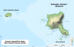 Map of the Solander Islands | |
 Overview map | |
| Geography | |
| Location | Southland District |
| Coordinates | |
| Area | 120 ha (300 acres) |
| Length | 1.6 km (0.99 mi) |
| Highest elevation | 330 m (1080 ft) |
| Administration | |
New Zealand | |
The islands are the tip of a larger submerged volcano, roughly equivalent in size to Mount Taranaki.[2] It was formerly believed that the volcano last erupted roughly 2 million years ago, but in 2010 radiometric dating of rock samples from the island found that it was between 150,000 and 400,000 years old.[3]
Islands
Solander Island / Hautere (also known in Māori as Te Niho a Kewa), the main island, covers around 1 km2 (0.39 sq mi), rising steeply to a peak 330 metres (1,083 ft) above sea level. It is wooded except for its northeast end, mainly a bare, white rock. A deep cave is on the east side, Sealers Cave. Little Solander Island is 1.9 km (1.2 mi) west. It reaches 148 m (486 ft) high yet covers 4 ha (9.9 acres). It has a barren appearance and is guano-covered. Pierced Rock is 250 m (273 yd) south of the main island. It rises to 54 m (177 ft) and covers 2,000 m2 (22,000 sq ft) (0.2 ha).
History

The island chain was sighted by Captain James Cook on 11 March 1770 and named by him after the Swedish naturalist Daniel Solander, one of the scientific crew aboard Cook's ship, Endeavour.[4]
The islands are geographically forbidding and weather conditions often confound the approach of ships, dissuading attempts at permanent habitation. Australian sealers briefly made use of the islands during the early 19th century, likely living on small flats between the island's cliffs and its shoreline for stints of a few months.[5] Castaways would occasionally end up on the islands, and in 1813, a passing ship bound for Stewart Island found five men in need of rescue. The men – four Europeans and one Australian aboriginal – were marooned there between 1808 and 1813, representing the longest continual period of habitation on the islands. They are thought to have been left ashore in two groups for seal hunting (sealing), but the sea prevented the approach of any ship to recover them. In 1810, sealing moved to Macquarie Island, farther to the west, and they were effectively abandoned. When rediscovered in 1813, it is likely that they had amassed many dried seal pelts.[5]
Geology
The islands are remnants of an isolated extinct Pleistocene volcano with andesite rocks, 150 to 400 thousand years old. They lie on a bank with depths less than 100 m (328 ft), separated from the continental shelf along Foveaux Strait by a 4 km (2.5 mi) but narrow trough 200 m (656 ft) deep (at least 237 m or 778 ft). Therefore, the islands are included in the New Zealand Outlying Islands.
The islands are the only volcanic land in New Zealand related to the subduction of the Australian Plate beneath the Pacific Plate[6] along the Puysegur Trench, which extends southwards from the end of the Alpine Fault.[7]
Flora and fauna
There are 53 vascular plant species, one third of which are very rare. The flora is dominated by ferns and orchids. The southern, and nominate, subspecies of Buller's albatross (Thalassarche b. bulleri) breeds only on the Solanders and the Snares.
The Solander Islands were historically a well-known area for migrating whales, especially southern right and sperm whales. Sperm whales in this area were said to be exceptionally large.[8]
Bird life
The islands are home to a variety of bird life.[9]
The Solander group has been identified as an Important Bird Area (IBA) by BirdLife International because of its significance as a breeding site for Buller's albatrosses (with about 5000 pairs) and common diving petrels.[10]
See also
- New Zealand outlying islands
- List of islands of New Zealand
- List of islands
- Desert island
References
- "Data Table - Protected Areas - LINZ Data Service (recorded area 120 ha)". Land Information New Zealand. Retrieved 27 August 2019.
- "Solander Island – an extinct volcano". Science Learning Hub. Retrieved 19 February 2022.
- "Solander Island / Media Releases and News / News and Events / Home - GNS Science". www.gns.cri.nz. Retrieved 19 February 2022.
- Lee, Garry J. "Science on the Map: Places in New Zealand Named After Scientists". The Rutherford Journal. Retrieved 20 April 2019.
- McNab, Robert (1905). Murihiku: A History of the South Island of New Zealand and the Islands Adjacent and Lying to the South, from 1642 to 1835. Cambridge University Press (republished 2011). pp. 208–211. ISBN 9781108039994. Retrieved 21 March 2019.
- Keith Lewis, Scott D. Nodder and Lionel Carter. 'Sea floor geology – Solander Island', Te Ara – the Encyclopedia of New Zealand. Updated 21 September 2007. Retrieved 29 March 2009.
- "Alpine Fault". www.otago.ac.nz. Department of Geology, Otago University. Retrieved 18 August 2022.
- http://docs.niwa.co.nz/library/public/NIWAis76.pdf [bare URL PDF]
- O'Donnell, Colin F.J. "Birds and mammals of Solander (Hautere) Island." Notornis 27: 21-44" (PDF). Notornis vol. 27). pp. 21–44.
- BirdLife International. (2012). Important Bird Areas factsheet: Solander Islands. Downloaded from http://www.birdlife.org on 27 January 2012.
- Wise's New Zealand guide: A gazetteer of New Zealand (4th ed.) (1969) Dunedin: H. Wise & Co. (N.Z.) Ltd.
External links
Administrative divisions of the Realm of New Zealand | |||||||||||||||||||||||||||||||||||
|---|---|---|---|---|---|---|---|---|---|---|---|---|---|---|---|---|---|---|---|---|---|---|---|---|---|---|---|---|---|---|---|---|---|---|---|
| |||||||||||||||||||||||||||||||||||
На других языках
[de] Solander Islands
Die Solander Islands sind eine aus zwei Inseln bestehende kleine Inselgruppe südlich der Südinsel von Neuseeland. Die beiden Inseln, Solander Island (Māori: Te Niho a Kewa)[1] und die kleineren Little Solander Island sind verwaltungstechnisch dem Southland District zugeordnet.- [en] Solander Islands
[fr] Îles Solander
Les îles Solander, en anglais Solander Islands, en maori de Nouvelle-Zélande Hautere, sont un petit archipel inhabité de Nouvelle-Zélande situé en mer de Tasman, au sud-sud-ouest des côtes de l'île du Sud, à une soixantaine de kilomètres à l'ouest de l'île Stewart et de l'entrée occidentale du détroit de Foveaux.Другой контент может иметь иную лицензию. Перед использованием материалов сайта WikiSort.org внимательно изучите правила лицензирования конкретных элементов наполнения сайта.
WikiSort.org - проект по пересортировке и дополнению контента Википедии