geo.wikisort.org - Mountains
The Anti-Lebanon Mountains (Arabic: جبال لبنان الشرقية, romanized: Jibāl Lubnān ash-Sharqiyyah, lit. 'Eastern Mountains of Lebanon'; Lebanese Arabic: جبال الشرقية, Jbel esh-Shar'iyyeh, "Eastern Mountains") are a southwest–northeast-trending mountain range that forms most of the border between Syria and Lebanon. The border is largely defined along the crest of the range. Most of the range lies in Syria.
This article needs additional citations for verification. (December 2009) |
| Anti-Lebanon Mountains | |
|---|---|
| جبال لبنان الشرقية | |
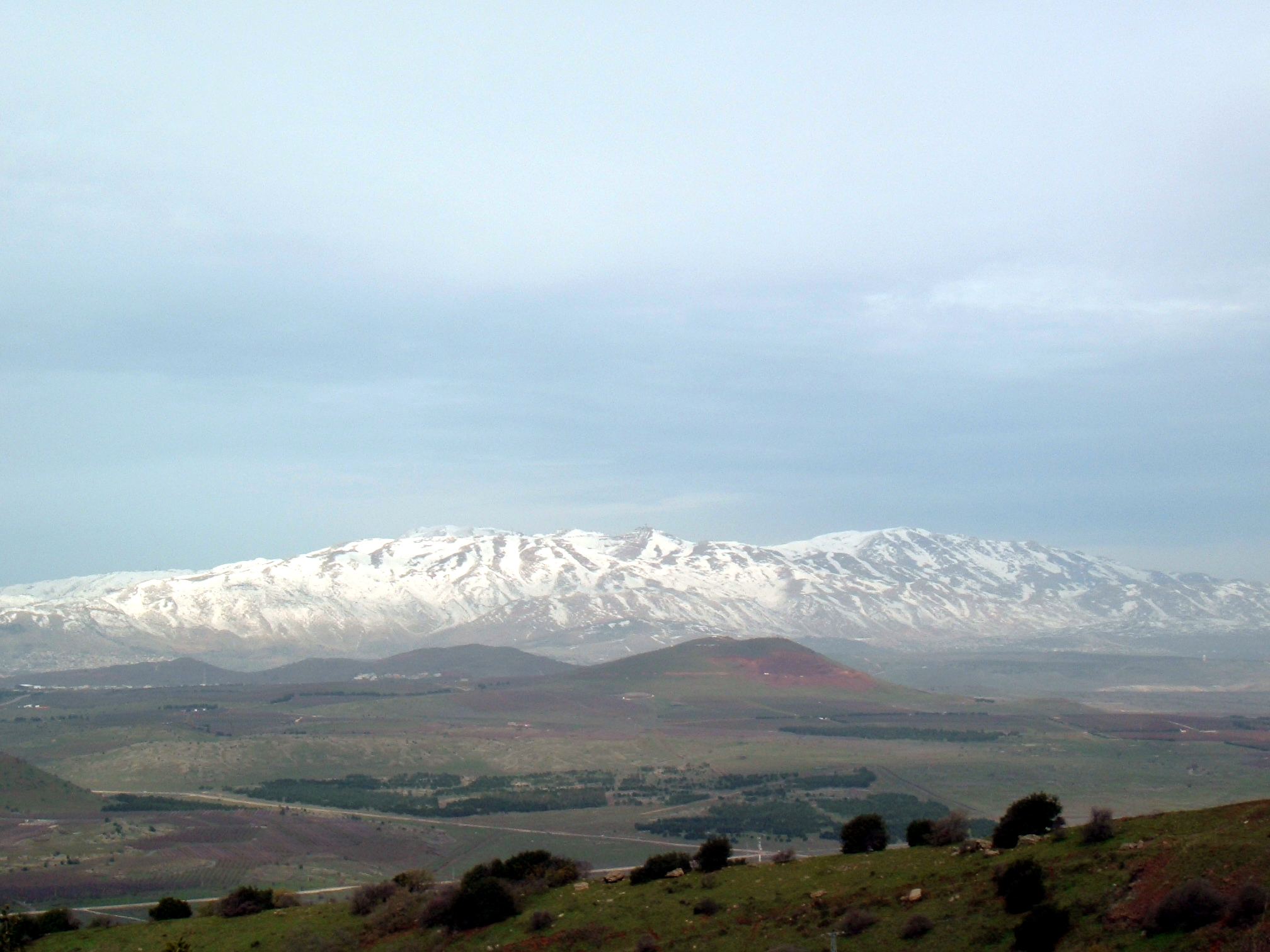 Mount Hermon, highest point in the Anti-Lebanon range, looking north from Mount Bental | |
| Highest point | |
| Peak | Mount Hermon |
| Elevation | 2,814 m (9,232 ft) |
| Dimensions | |
| Length | 150 km (93 mi) |
| Geography | |
 Satellite image of Lebanon. The snow-covered areas nearer the coast are the Mount Lebanon range and the snow-covered areas further inland are the Anti-Lebanon mountain range.
| |
| Location | Syria, Lebanon, Golan Heights (occupied by Israel) |
| Range coordinates | 34°N 36.5°E |
Etymology
Its Western name Anti-Lebanon comes from the Greek and Latin Antilibanus, derived from its position opposite (anti-) and parallel to the Mount Lebanon range (Libanus).
Geology
The Anti-Lebanon range is approximately 150 kilometres (93 miles) in length. To the south, the range adjoins the lower-lying Golan Heights plateau, but includes the highest peaks, namely Mount Hermon (Jabal el-Shaykh, in Arabic), at 2,814 metres, and Ta'la't Musa, at 2,669 metres. These peaks, on the Lebanese-Syrian border, are snow-covered for much of the year.
Anti-Lebanon mountains are an anticline. Their predominant rocks are limestone and chalk from the Jurassic period.
Geography
To the north, they extend to almost the latitude of the Syrian city of Homs. The mountains end in the south with Mount Hermon, which borders on the Golan Heights; the Golan Heights are a different geological and geomorphological entity, but geopolitically they are often regarded together with the southern slopes of Mount Hermon, both being part of the Israeli-occupied Golan region. To the west of the Anti-Lebanon lie valleys that separate it from Mount Lebanon in central Lebanon: Beqaa Valley in the north and the Hasbani River valley in the south. To the east, in Syria, lies the Eastern Plateau, location of the city of Damascus.
The mountains provide a rain shadow to the region on their east, such as Beqaa Valley and even the Syrian Desert, which fall on the leeward side of the mountains.
An important smuggling route between Lebanon and Syria passes through the Anti-Lebanon Mountains.[1]
Ecology
The area is known for its apricot and cherry trees as well as its stone quarries.[1] In the mountains, amygdalus and pistachio bushes thrive. On the west side small-scale deciduous forests and isolated dry coniferous forests with Cilician firs (Abies cilicica), Lebanon cedars (Cedrus libani) and Greek juniper (Juniperus excelsa). Subalpine and alpine plant communities occur over 2500 metres. The grazing by sheep and goats, has led to an increased erosion of the remaining forests and to a substantial deterioration of soil and vegetation. The predominant form of economy is extensive nomadic grazing.
There are various endemic flora found and named after the region (having a specific epithet that means "of the Anti-Lebanon"). These include Euphorbia antilibanotica, Teucrium antilibanoticum, Valerianella antilibanotica,[2] and Iris antilibanotica.[3]
See also
- Song of Songs 4
References
- Bulos, Nabih (2017-07-31). "Lebanon's Hezbollah group insists: We're not the 'menace' Trump says we are". Los Angeles Times. ISSN 0458-3035. Retrieved 2017-09-23.
- "Eastern Mediterranean Endemic Plants". terrestrial-biozones.net. Retrieved 25 March 2016.
- "Iris antilibanotica Dinsm. is an accepted name". theplantlist.org (The Plant List). Retrieved 25 March 2016.
Authority control | |
|---|---|
| General |
|
| National libraries | |
Earth's primary regions and subregions | |||||||||||||||||||||||||||||||||||||||||||||||||||||
|---|---|---|---|---|---|---|---|---|---|---|---|---|---|---|---|---|---|---|---|---|---|---|---|---|---|---|---|---|---|---|---|---|---|---|---|---|---|---|---|---|---|---|---|---|---|---|---|---|---|---|---|---|---|
| |||||||||||||||||||||||||||||||||||||||||||||||||||||
На других языках
[de] Anti-Libanon
Der Anti-Libanon (arabisch سلسلة جبال لبنان الشرقية, DMG Silsilat Ǧibāl Lubnān aš-šarqiyya ‚östliche Libanon-Gebirgskette‘, hebräisch .mw-parser-output .Hebr{font-size:115%}מול הלבנון .mw-parser-output .Latn{font-family:"Akzidenz Grotesk","Arial","Avant Garde Gothic","Calibri","Futura","Geneva","Gill Sans","Helvetica","Lucida Grande","Lucida Sans Unicode","Lucida Grande","Stone Sans","Tahoma","Trebuchet","Univers","Verdana"}Mol HaLewanon) ist ein Gebirge, das sich zwischen den Staaten Libanon und Syrien über 150 km Länge von Nordosten nach Südwesten erstreckt und parallel zur Mittelmeerküste verläuft.- [en] Anti-Lebanon Mountains
[es] Cordillera del Antilíbano
La cordillera del Antilíbano (en árabe,جبال لبنان الشرقية Jabal Lubnan ash-Sharqi) se encuentra entre los países de Siria y Líbano, siendo la frontera natural entre estos. Tiene aproximadamente 150 kilómetros de longitud. Al norte, se extiende hasta casi la latitud de la ciudad siria de Homs.[fr] Anti-Liban
L'Anti-Liban (arabe : سلسلة جبال لبنان الشرقية, « Montagne orientale du Liban ») est une chaîne de montagnes du Proche-Orient culminant à 2 814 mètres d'altitude. Parallèle à la chaîne du mont Liban, elle en est séparée par la vallée de la Bekaa. Sa ligne de crête correspond à peu près à la frontière libano-syrienne.[it] Anti-Libano
L'Anti-Libano è una catena montuosa parallela alla catena montuosa del Monte Libano.[1][ru] Антиливан
Антилива́н[1] (араб. جبال لبنان الشرقية, Любна́н-эш-Шарки́я, или араб. الجبل الشرقي, Эш-Шарки[2]) — горная цепь, протянувшаяся с юго-запада на северо-восток между Ливаном и Сирией[3]. Граница Сирии и Ливана проходит, в основном, по верхней части горной цепи. Южная оконечность гор находится на территории Голанских высот[источник не указан 2518 дней]. Горы находятся к востоку от хребта Ливан, который идет в параллельном направлении. Название с греческого переводится как «напротив Ливана». К западу находится долина Бекаа (на севере) и долина реки Эль-Хасбани (на юге). Эти долины отделяют Антиливан от хребта Ливан в Центральном Ливане. На востоке, в Сирии, лежит Восточное плато[источник не указан 2518 дней], на котором расположился город Дамаск.Другой контент может иметь иную лицензию. Перед использованием материалов сайта WikiSort.org внимательно изучите правила лицензирования конкретных элементов наполнения сайта.
WikiSort.org - проект по пересортировке и дополнению контента Википедии