geo.wikisort.org - Mountains
Mount Hermon (Arabic: جبل الشيخ or جبل حرمون / ALA-LC: Jabal al-Shaykh ("Mountain of the Sheikh") or Jabal Haramun; Hebrew: הַר חֶרְמוֹן, Har Hermon) is a mountain cluster constituting the southern end of the Anti-Lebanon mountain range. Its summit straddles the border between Syria and Lebanon[1] and, at 2,814 m (9,232 ft) above sea level, is the highest point in Syria.[2] On the top, in the United Nations buffer zone between Syrian and Israeli-occupied territories, is the highest permanently manned UN position in the world, known as "Hermon Hotel",[3] located at 2814 metres altitude.[4] The southern slopes of Mount Hermon extend to the Israeli-occupied portion of the Golan Heights, where the Mount Hermon ski resort is located[5] with a top elevation of 2,040 metres (6,690 ft).[6] A peak in this area rising to 2,236 m (7,336 ft) is the highest elevation in Israeli-controlled territory.[7]
| Mount Hermon | |
|---|---|
| Arabic: Jabal ash-Shaykh Hebrew: Har Hermon | |
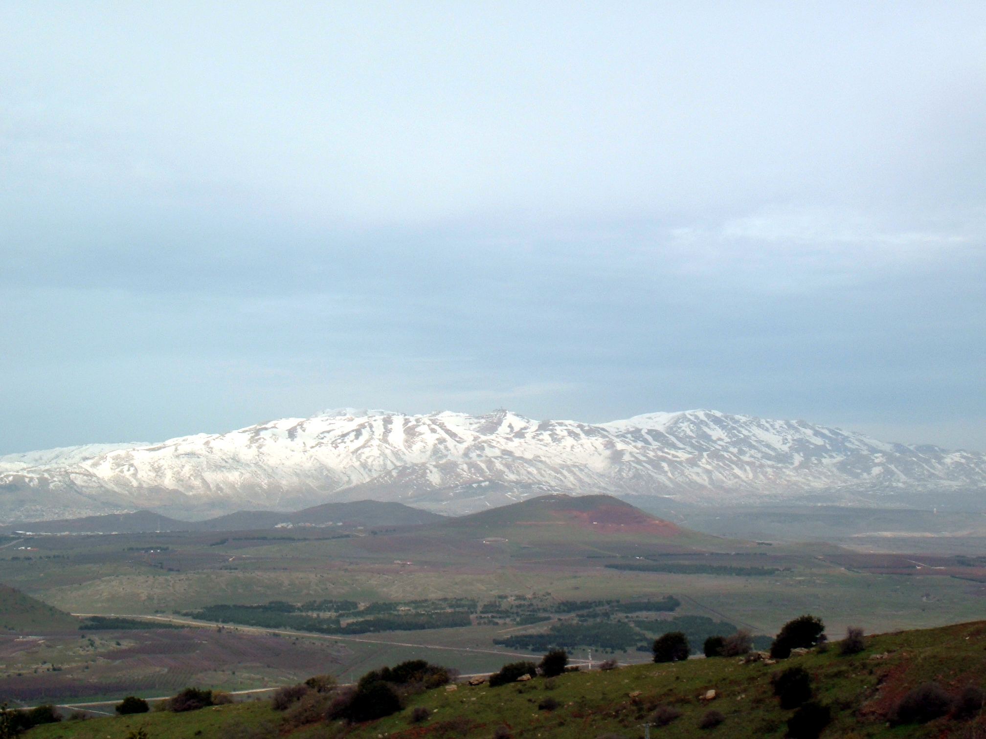 Mount Hermon, viewed from Mount Bental in the Golan Heights | |
| Highest point | |
| Elevation | 2,814 m (9,232 ft) |
| Prominence | 1,804 m (5,919 ft) |
| Listing | Country high point Ultra |
| Coordinates | 33°24′58″N 35°51′27″E |
| Geography | |
 Mount Hermon Mount Hermon's summit straddles the border between Lebanon and Syria. | |
| Location | Syria (southern slopes are located in the Israeli-occupied Golan Heights) Lebanon |
| Parent range | Anti-Lebanon mountain range |
Geography
Wider mountain range
The Anti-Lebanon range, of which the Hermon range constitutes the southernmost part, extends for approximately 150 km (93 mi) in a northeast–southwest direction, running parallel to the Lebanon range on the west.[8]
Hermon range
The relatively narrow Hermon range, with the Lebanon-Syria boundary along its spine, extends for 70 km, from 25 km northeast of Mt. Hermon to 45 km southwest of it.[8] The Hermon range covers an area of about 700 km2 (270 sq mi) of which about 70 km2 (27 sq mi) are under Israeli control.[8] Mount Hermon is a cluster of mountains with three distinct summits, each about the same height.[8] Most of the portion of Mount Hermon within the Israeli-controlled area constitutes the Hermon nature reserve.[8][9]
Water and flora
The mountain forms one of the greatest geographic resources of the area. Because of its height it captures a great deal of precipitation in a very dry area of the world. The Jurassic limestone is broken by faults and solution channels to form a karst topography. Mount Hermon has seasonal winter and spring snow falls, which cover all three of its peaks for most of the year. Melt water from the snow-covered mountain's western and southern bases seeps into the rock channels and pores, feeding springs at the base of the mountain, which form streams and rivers. These merge to become the Jordan River. Additionally, the runoff facilitates fertile plant life below the snow line, where vineyards and pine, oak, and poplar trees are abundant.[10]
Strategic importance
The springs, and the mountain itself, are much contested by the nations of the area for the use of the water. Mount Hermon is also called the "snowy mountain," the "gray-haired mountain", and the "mountain of snow". It is also called "the eyes of the nation" in Israel because its elevation makes it Israel's primary strategic early warning system.[11][12]
Religious importance since Antiquity
- See also Temples of Mount Hermon
Various temples can be found in villages on the slopes of Mount Hermon.
Mount Hermon's name has been related to the Semitic root ḥrm, which means "taboo" or "consecrated", and the Arabic term al-ḥaram, which means "sacred enclosure".[13]
Epic of Gilgamesh
The Epic of Gilgamesh mentions that Mount Hermon split after Gilgamesh killed Humbaba, the Guardian of the Cedar Forest. One translation of Tablet V states, "The ground split open with the heels of their feet, as they whirled around in circles Mt. Hermon and Lebanon split."[14]
Ugaritic religion
The mountain or summit is referred to as Saphon in Ugaritic texts where the palace of Ba'al is located in a myth about Attar.[15][16]
Hebrew Bible and apocrypha
In Deuteronomy 3:8–9 and Joshua 12:1 and 13:11, Mount Hermon is depicted as the northern boundary of the Amorite kingdom, which following the conquest by Joshua was awarded to the half-tribe of Manasseh east of the Jordan River.[17]
The Hebrew Bible uses three names for Mount Hermon, stating in Deut 3:9 that "the Sidonians call Hermon Sirion, while the Amorites call it Senir", but elsewhere (1Chr 5:23) seems to distinguish between Senir and Hermon, probably using the names for two of the three peaks of the Hermon range, while in Psalm 42:6 the Hebrew text uses the plural form, Hermonim, possibly also a reference to the three peaks.[18][19]
The Book of Chronicles mentions Mount Hermon as a place where Epher, Ishi, Eliel, Azriel, Jeremiah, Hodaviah, and Jahdiel were the heads of their families (1 Chronicles 5:23–24).
In Psalm 42, which leads the Psalms of the northern kingdom, the Psalmist remembers God from the land of Jordan and the Hermonites. In Song of Songs 4:8, Hermon is an instance of an exotic locale, and Psalm 133, one of the Songs of Ascents, makes specific reference to the abundant dew formation upon Mount Hermon.[20] The Book of Ezekiel (27:5), meanwhile, praises its cypresses (referring to it by its alternate name Senir (cf. Deut. 3:9).
In the apocryphal Book of Enoch, Mount Hermon is the place where the Watcher class of fallen angels descended to Earth. They swear upon the mountain that they would take wives among the daughters of men and take mutual imprecation for their sin (Enoch 6).
According to the controversial research by Professor Israel Knohl of the Hebrew University, in his book "Hashem", Mount Hermon is actually the Mount Sinai mentioned in the Hebrew Bible, with the biblical story reminiscent of an ancient battle of the northern tribes with the Egyptians somewhere in the Jordan valley or Golan heights.[21]
New Testament
R.T. France, in his book on the Gospel of Matthew, noted that Mount Hermon was a possible location of the Transfiguration of Jesus, [22][23] just as it has elsewhere been described as the site accepted by most scholars.[24]
Qasr Antar inscription and Hermon as the "mountain of oath"
There is a sacred building made of hewn blocks of stone on the summit of Mount Hermon. Known as Qasr Antar, it is the highest temple of the ancient world and was documented by Sir Charles Warren in 1869. An inscription on a limestone stele recovered by Warren from Qasr Antar was translated by George Nickelsburg to read "According to the command of the greatest a(nd) Holy God, those who take an oath (proceed) from here." Nickelsburg connected the inscription with the oath taken by the angels under Semjaza who took an oath together, bound by a curse, in order to take human wives in the Book of Enoch (1 Enoch 6:6). Hermon was said to have become known as "the mountain of oath" by Charles Simon Clermont-Ganneau. The name of God was supposed to be a Hellenized version of Baʿal or Hadad and Nickelsburg connected it with the place name of Baal-Hermon (Lord of Hermon) and the deity given by Enoch as "The Great Holy One".[25]
Deir El Aachayer Roman temple
Another Greek inscription found in a large temple at Deir El Aachayer on the northern slopes notes the year that a bench was installed "in the year 242, under Beeliabos, also called Diototos, son of Abedanos, high priest of the gods of Kiboreia". The era of the gods of Kiboreia is not certain, nor is their location, which is not conclusively to be identified with Deir al-Achayer, but was possibly the Roman sanctuary or the name of a settlement in the area.[26]
Religious importance in the Late Roman period
Eusebius recognized the religious importance of Hermon in his work Onomasticon (probably written in the first quarter of the 4th century), saying "Until today, the mount in front of Banias and Lebanon is known as Hermon and it is respected by nations as a sanctuary".[13]
Climate
| Climate data for Hermon (1640 meters above sea level) | |||||||||||||
|---|---|---|---|---|---|---|---|---|---|---|---|---|---|
| Month | Jan | Feb | Mar | Apr | May | Jun | Jul | Aug | Sep | Oct | Nov | Dec | Year |
| Average high °C (°F) | 3.3 (37.9) |
4.0 (39.2) |
7.6 (45.7) |
12.0 (53.6) |
16.0 (60.8) |
19.4 (66.9) |
21.6 (70.9) |
21.7 (71.1) |
19.1 (66.4) |
15.3 (59.5) |
10.2 (50.4) |
5.1 (41.2) |
12.9 (55.3) |
| Daily mean °C (°F) | 1.2 (34.2) |
1.9 (35.4) |
4.1 (39.4) |
7.5 (45.5) |
11.2 (52.2) |
14.5 (58.1) |
16.8 (62.2) |
16.7 (62.1) |
14.3 (57.7) |
11.2 (52.2) |
7.0 (44.6) |
3.3 (37.9) |
9.1 (48.5) |
| Average low °C (°F) | −2.2 (28.0) |
−3.1 (26.4) |
0.6 (33.1) |
3.1 (37.6) |
6.4 (43.5) |
9.6 (49.3) |
12.0 (53.6) |
11.8 (53.2) |
9.5 (49.1) |
7.2 (45.0) |
2.7 (36.9) |
−0.5 (31.1) |
4.8 (40.6) |
| Average rainfall mm (inches) | 300.3 (11.82) |
250.4 (9.86) |
138.8 (5.46) |
100.2 (3.94) |
30.2 (1.19) |
7.5 (0.30) |
1.7 (0.07) |
0.9 (0.04) |
10.4 (0.41) |
110.6 (4.35) |
175.3 (6.90) |
226.5 (8.92) |
1,352.8 (53.26) |
| Average rainy days | 20.8 | 19.3 | 11.5 | 8.8 | 5.8 | 2.3 | 0.7 | 0.6 | 3.5 | 11.2 | 15.5 | 18.9 | 118.9 |
| [citation needed] | |||||||||||||
Arab-Israeli conflict
1967 Six-Day War
During the Six-Day War in June 1967, a part of Mount Hermon in Syria was captured by Israel.
1973 Yom Kippur War
This part was regained by Syria on October 6, 1973, the first day of the Yom Kippur War, following the First Battle of Mount Hermon. After being repelled in the Second Battle of Mount Hermon, the IDF recaptured both the formerly Israeli-occupied sector and the pre-Yom Kippur War Syrian-controlled sector on October 21, 1973, during Operation Dessert,[27] also known as the Third battle of Mount Hermon.
After 1973
The pre-Yom Kippur War Syrian-controlled sector was returned to Syria after the war.[28]
The Israeli-occupied sector of the mountain became patrolled by the Israel Defense Forces and the Israel Police, and the Israeli Security Forces have maintained a strategic observation post for monitoring Syrian and Lebanese military activity near Mitzpe Shlagim ("Snow Lookout"), which is at an elevation of about 2,224 m (7,300 ft). Its neighboring peak, at 2,236 m (7,336 ft), is the highest elevation in Israeli-occupied territory.[7]
Syrian Civil War
Since the onset of Syrian Civil War, the Syrian-controlled Hermon has continued to be under pro-government forces, though clashes have sporadically erupted on the mountain range and spilled into Lebanon and the Israeli-occupied portion. Most notably the Islamist rebel factions of Jaish al-Haramoun took part in the fighting on the Southern slopes of the mountain.
Ski resort

Since 1981, when the Golan Heights Law was passed, the Israeli-occupied portion of the Golan Heights has been governed under Israeli law. Mount Hermon hosts the only ski resort in territory held by Israel, including a wide range of ski trails at novice, intermediate, and expert levels. It also offers additional winter family activities such as sledding and Nordic skiing. Those who operate the Hermon Ski area live in the nearby Israeli settlement of Neve Ativ and the Druze town of Majdal Shams. The ski resort has a ski school, ski patrol, and several restaurants located at either the bottom or peak of the area.[citation needed]
In 2005, the Syrian government had plans to develop a 15-billion-dollar ski resort on the slopes of the mountain.[29]
See also
- Hermon nature reserve
- Mountains in the Golan Heights
- List of elevation extremes by country
- Iris hermona
Notes
References
- "ACME Mapper terrain display". mapper.acme.com. Archived from the original on 6 October 2014. Retrieved 28 March 2016.
- "CIA World Fact Book: Syria". 14 November 2011. Retrieved 27 November 2011.
highest point: Mount Hermon 2,814 m
- Gröppel, Ekkehard (April–June 2013). "It is time to say Goodbye!" (PDF). Golan: The UNDOF Journal. United Nations Disengagement Observer Force (135): 10–15. Retrieved 15 July 2015.
- "Mt Hermon – UNDOF's Vital Ground" (PDF). Golan: The UNDOF Journal. United Nations Disengagement Observer Force (144). July–September 2015. Retrieved 18 April 2019.
- The World's 18 Strangest Ski Resorts: The Mount Hermon Ski Resort Archived 2014-10-06 at the Wayback Machine, Shannon Hassett, Popular Mechanics
- The Hermon Ski Resort: About, homepage of the resort, accessed 9 August 2019
- Cordesman, Anthony H. (2008). Israel and Syria. USA: Center for Strategic and International Studies. p. 222. ISBN 978-0-313-35520-2. Retrieved 2 September 2011.
Its adjacent peak, at 2,236 meters, is the highest elevation in Israel.
- The Hermon entry area Israeli Liberary of Technology for Education (in Hebrew)
- The Hermon Shoulder Israeli Ministry of Environment website (in Hebrew)
- The vegetation of Mount Hermon Mike Livneh (In Hebrew, Israel Mofet Unit of Research and Development, Dept. Of Education)
- If UN positions on Syria border fall to radicals Israel will have to respond Yacov Lapin, January 13, 2016 (Jerusalem Post)
- The Eyes of the Country have Closed Death of the soldier who coined the term "The eyes of the country" for a battle on the Hermon Mountain (in Hebrew, Ynet, 30 November 2006)
- E. A. Myers (11 February 2010). The Ituraeans and the Roman Near East: Reassessing the Sources. Cambridge University Press. pp. 65–. ISBN 978-0-521-51887-1. Retrieved 18 September 2012.
- Kovacs, Maureen (1989). The Epic of Gilgamesh. Stanford, California: Stanford University Press. p. 43. ISBN 0804715890.
- John C. L. Gibson; Nick Wyatt; Wilfred G. E. Watson; Jeffery B. Lloyd (1996). Ugarit, religion and culture: proceedings of the International Colloquium on Ugarit, religion and culture, Edinburgh, July 1994 : essays presented in honour of Professor John C.L. Gibson. Ugarit-Verlag. ISBN 978-3-927120-37-2. Retrieved 20 June 2011.
- Manfried Dietrich; Oswald Loretz (1996). Ugarit-Forschungen, p. 236. Verlag Butzon & Bercker. ISBN 978-3-7887-1588-5. Retrieved 20 June 2011.
- "Mount Hermon". Encyclopedia Judaica. Retrieved 8 June 2020 – via Jewish Virtual Library.
- Powell, Mark Allan, ed. (2009). Hermon. HarperCollins Bible Dictionary (condensed ed.). HarperCollins with the Society of Biblical Literature. ISBN 0061469076. Retrieved 20 July 2022 – via BibleOdyssey.org.
- Bible: Commentaries: Psalm 42:6 at Bible Hub for "Hermonim" with various interpretations. Accessed 20 July 2022.
- Clifford, Richard J. (1 November 2003). Abingdon Old Testament Commentaries: Psalms 73-150. Abingdon Press. pp. 263–264. ISBN 978-1-4267-6009-9.
“Hermon” is an instance of an exotic locale, as in Song 4:8, where it occurs with several other place names. Mount Hermon was famous for its heavy dew. Though the Mediterranean climate of Palestine had no rainfall from May or June to September, it had dew. Dew was important in the summer and a supplement to rain. Zion was therefore a place of fertility which even in the rainless season has an abundance of dew, like that of mighty Hermon to the north. So plentiful is it that it “runs down [NRSV: “falls on”] the mountains of Zion” (Ps 133:3).
- Pharaoh’s War with the Israelites: The Untold Story Israel Knohl, Azure Magazine #41, Summer 2010 (Azure Magazine website)
- R.T. France, Matthew: An Introduction and Commentary (Tyndale New Testament Commentaries) (IVP Academic, 2008)
- Harrington, Daniel (1991). Sacra Pagina: The Gospel of Matthew. Collegeville, Minnesota: The Liturgical Press. p. 253. ISBN 0-8146-5803-2.
- Bromiley, Geoffrey William, ed. International Standard Bible Encyclopedia. "Transfiguration, Mount of." William B. Eerdmans Publishing, 1988.
- Nickelsburg, 1 Enoch 1. A Commentary on the Book of 1 Enoch, 1–36; 81–108 (Minneapolis: Fortress, 2001.
- Fergus Millar (1993). The Roman Near East, 31 B.C.-A.D. 337. Harvard University Press. pp. 311–. ISBN 978-0-674-77886-3. Retrieved 18 September 2012.
- "The Yom Kippur War". Ynetnews. 2008-11-11. Retrieved 24 November 2008.
- "Syria". Ynetnews. 2007-12-23. Retrieved 25 November 2008.
- "Syria unveils 15 billion dollar tourism project". Middle East Online. Dec 20, 2005. Archived from the original on September 28, 2007.
External links
 Media related to Mount Hermon at Wikimedia Commons
- . Encyclopædia Britannica (11th ed.). 1911.
| Authority control |
|
|---|
На других языках
[de] Hermon
Der Hermon (hebräisch .mw-parser-output .Hebr{font-size:115%}הַר חֶרְמוֹן, AHL har Ḥermon; arabisch جبل الشيخ, DMG ǧabal aš-šaiḫ, levantinisch-arabisch žäbäl əš-šēḫ) ist ein 2814 m hohes Bergmassiv im Nahen Osten im Grenzbereich zwischen Libanon, Israel und Syrien. Der Gipfel ist der höchste Berg Syriens.[1] An seiner Südwestflanke befindet sich der mit einer Höhe von 2224 m höchste Punkt der von Israel kontrollierten Golanhöhen.[2]- [en] Mount Hermon
[es] Monte Hermón
El monte Hermón (en hebreo, הר חרמון [Har Hermon]; en árabe, جبل الشيخ [Yabal al-Shayj]) es un conjunto de montañas situadas en la parte sur de la cordillera del Antilíbano. Estas cumbres sirven como frontera entre Israel (Altos del Golán), el Líbano y Siria. La montaña se yergue hasta los 2814 msnm de su cumbre que separa Líbano de la zona de seguridad controlada por las Naciones Unidas (UNDOF).[1] La ladera noroeste de la montaña pertenece al Líbano, la oriental a Siria y las laderas sudoeste y meridional, unos 100 km², se encuentran bajo control de Israel como resultado de su victoria durante la guerra de los Seis Días en 1967. Este sector de la montaña, así como los Altos del Golán, todo ello originalmente territorio sirio, fue anexionado al Distrito Norte por Israel en 1981. En Israel es llamado «los ojos de la Nación» debido a su altitud, siendo el principal Sistema Estratégico de Alerta Temprana israelí y el pico más alto de Israel. Es también el pico más alto de Siria[2] y el emplazamiento de la misión habitada de las Naciones Unidas de más altitud.[1][fr] Mont Hermon
Le mont Hermon (appelé en hébreu : הר חרמון, Har Hermon ; et en arabe : جبل الشيخ, Jabal ash-Shaykh, soit « montagne du cheikh » ou « mont enneigé » ou Haramoun) est une montagne de l'Anti-Liban, culminant à 2 814 mètres d'altitude.[it] Monte Hermon
Il monte Hermon (in italiano anche Ermon o Ermone[1]; in arabo: جبل الشيخ , Jabal al-Shaykh o حرمون, Haramūn; in ebraico: הר חרמון?, Har Ḥermon, "Monte del vecchio") è un Gruppo montuoso al confine tra Israele, Siria, Libano. Composto da roccia calcarea, costituisce la parte più meridionale della catena dell'Antilibano, ed è formato da tre cime, la più alta delle quali raggiunge i 2.814 m. Dove residua un pressoché estinto ghiacciaio. È citato spesso nella Bibbia, in quanto confine nord della Terra promessa. Secondo i cristiani potrebbe essere il luogo della trasfigurazione di Gesù, in alternativa al Monte Tabor.[ru] Хермон
Хе́рмо́н[1][2], или Эш-Шейх[1], также Ермо́н (араб. جبل الشيخ — Дже́бель-эш-Шейх[3], букв. «гора шейха»; ивр. הר חרמון — Хермо́н; происходит, вероятно, от חרם [хе́рем] — «запрет») — горный массив в горной цепи Антиливан[4]. Наивысшая точка — 2814 м над уровнем моря — является также самой высокой точкой всего Антиливана. Длина массива около 60 км, площадь около 1000 км². Эш-Шейх входит в водосборный бассейн трёх основных источников реки Иордан — Эль-Хасбани, Дан и Банияс.Другой контент может иметь иную лицензию. Перед использованием материалов сайта WikiSort.org внимательно изучите правила лицензирования конкретных элементов наполнения сайта.
WikiSort.org - проект по пересортировке и дополнению контента Википедии