geo.wikisort.org - Mountains
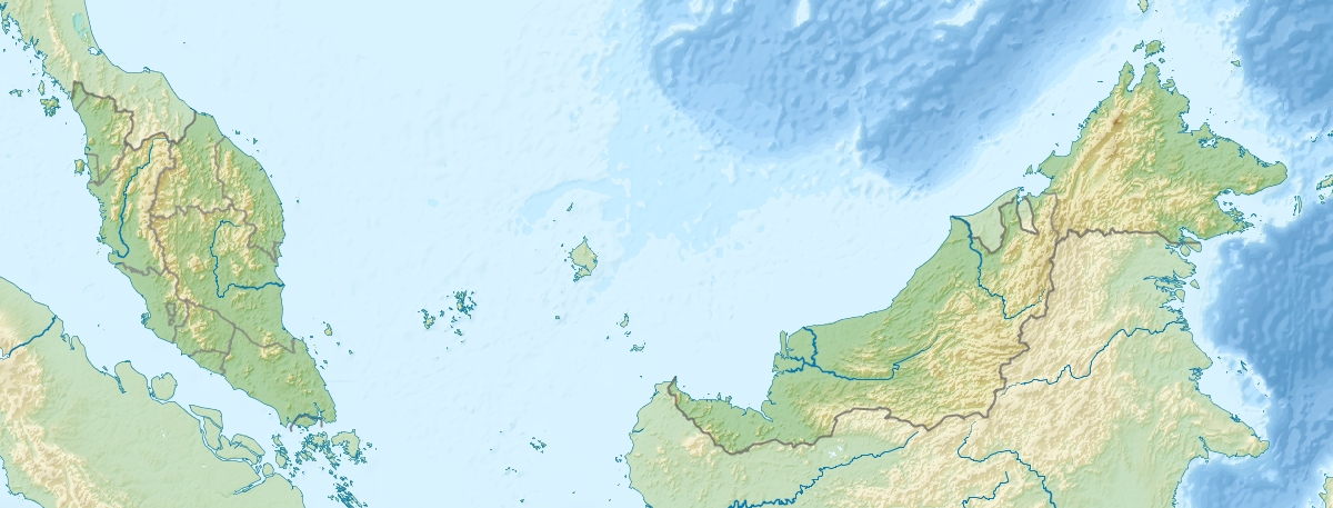
Mount Kinabalu (Malay: Gunung Kinabalu, Dusun: Gayo Ngaran or Nulu Nabalu) is the highest mountain in Borneo and Malaysia. With an elevation of 13,435 feet (4,095 m), it is third-highest peak of an island on Earth, and 20th most prominent mountain in the world by topographic prominence. The mountain is located in Ranau district, West Coast Division of Sabah, Malaysia. It is protected as Kinabalu Park, a World Heritage Site.
| Mount Kinabalu | |
|---|---|
 | |
| Highest point | |
| Elevation | 4,095 m (13,435 ft) |
| Prominence | 4,095 m (13,435 ft) Ranked 20th |
| Isolation | 2,538 km (1,577 mi) |
| Listing | Country high point Ultra Spesial (Ribu) |
| Coordinates | 06°04′30″N 116°33′31″E |
| Naming | |
| Native name |
|
| Geography | |
 Mount Kinabalu Map showing location of Mount Kinabalu within Malaysia. | |
| Location | Ranau, West Coast Division, Sabah, Malaysia |
| Parent range | Crocker Range |
| Climbing | |
| First ascent | March 1851 Hugh Low (summit plateau) 1888 John Whitehead (highest peak) |
| Easiest route | Hiking |
In 1997, a re-survey using satellite technology established its summit (known as Low's Peak) height at 4,095 m (13,435 ft) above sea level, which is some 6 m (20 ft) less than the previously thought and hitherto published figure of 4,101 m (13,455 ft).[1]
The mountain and its surroundings are among the most important biological sites in the world, with between 5,000 and 6,000 species of plants, 326 species of birds, and more than 100 mammalian species identified. Among this rich collection of wildlife are famous species such as the gigantic Rafflesia plants and orangutans. Mount Kinabalu has been accorded UNESCO World Heritage status.[2][3][4]
Low's Peak can be climbed by a person in good physical condition and there is no need for mountaineering equipment at any point on the main route, but climbers must be accompanied by accredited guides at all times due to national park regulations and may experience altitude sickness.[5]
Biology
Mount Kinabalu along with other upland areas of the Crocker Range is known worldwide for its biodiversity with plants of Himalayan, Australasian, and Indomalayan origin. A recent botanical survey of the mountain estimated a staggering 5,000 to 6,000 plant species (excluding mosses and liverworts but including ferns),[1][6][7][8][9][10] which is more than all of Europe and North America (excluding tropical regions of Mexico) combined.[citation needed] It is therefore one of the world's most important biological sites. A reason for its rich diversity and endemisms is that its great height could have provided refuge to cold-adapted species during interglacials.[11]
In 2015, a major Malaysian-Dutch study showed that the unique flora, fauna, and fungi on the mountain summit are younger than the mountain itself, and have evolved from both local and distant montane ancestors.[12]
Flora
The flora covers the mountain in zones of different types of habitat as one climbs up, beginning with a lowland belt of fig trees and carnivorous pitcher plants. Then between 2,600 to 3,200 m (8,530 to 10,499 ft) is a layer of short trees such the conifer Dacrydium gibbsiae and dwarf shrubs, mosses, lichens, liverworts, and ferns. Finally many of the world's richest variety of orchids are found on the high rockier slopes.
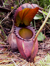
These plants have high levels of endemism (i.e. species which are found only within Kinabalu Park and are not found anywhere else in the world). The orchids are the best-known example with over 800 species including some of the highly valued Paphiopedilum slipper orchids, but there are also over 600 species of ferns (more than the whole of Africa's 500 species) of which 50 are found nowhere else, and the richest collection in the world for the Nepenthes pitcher plants (five of the thirteen are found nowhere else on earth) which reach spectacular proportions (the largest-pitchered in the world being the endemic Nepenthes rajah).[1][13][14] The parasitic Rafflesia plant, which has the largest single flower in the world, is also found in Kinabalu (particularly Rafflesia keithii whose flower grows to 94 cm (37 in) in diameter),[1] though blooms of the flower are rare and difficult to find. Meanwhile, another Rafflesia species, Rafflesia tengku-adlinii, can be found on the neighbouring Mount Trus Madi and the nearby Maliau Basin.
Its above average biodiversity in plant life is due to a combination of several unique factors: its setting in one of the richest plant regions of the world (the tropical biogeographical region known as western Malesia which comprises the island of Sumatra, the Malay Peninsula, and the island of Borneo), the fact that the mountain covers a wide climatic range from near sea level to freezing ground conditions near the summit, the jagged terrain and diversity of rocks and soils, the high levels of rainfall (averaging about 2,700 mm (110 in) a year at park HQ), and the climatic instability caused by periods of glaciation and catastrophic droughts which result in evolution and speciation. This diversity is greatest in the lowland regions (consisting of lowland dipterocarp forests, so called because the tree family Dipterocarpaceae are dominant). However, most of Kinabalu's endemic species are found in the mountain forests, particularly on ultramafic soils (i.e. soils which are low in phosphates and high in iron and metals poisonous to many plants; this high toxic content gave rise to the development of distinctive plant species found nowhere else).[1]
Fauna

The variety of plant life is also habitat for a great variety of birds and mammals.[15] There are some 326 species of birds in Kinabalu Park, including the spectacular rhinoceros hornbill, mountain serpent-eagle, Dulit frogmouth, eyebrowed jungle flycatcher, and bare-headed laughingthrush. Twenty-four birds are mainly found on the mountain. The mountain is home to some 100 mammalian species mostly living high in the trees, including one of the four great apes, the orangutan (though sightings of these are uncommon; estimates of its numbers in the park range from 25 to 120).[1] Other mammals include three kinds of deer, the Malayan weasel (Mustela nudipes), oriental small-clawed otter (Aonyx cinerea), and leopard cat (Felis bengalensis). Endemic mammals include the black shrew (Suncus ater). However, others of its endemisms, such as the Bornean ferret-badger (Melogale everetti) and Rattus baluensis, have also recently been recorded in the nearby Mount Tambuyukon.[11]
Endemic annelids number less than a dozen known species but include the Kinabalu giant red leech that preys on various earthworms, including the Kinabalu giant earthworm.[16] In the summit zone, at least 26 endemic species of land snail exist.[17] In 2012, a major scientific expedition, jointly organised by the Malaysian Sabah Parks and the Dutch Naturalis Biodiversity Center, performed DNA analysis of several dozen endemic flora, fauna, and fungi, to understand the evolutionary origin of the unique biodiversity of Kinabalu.[18]
Threats and preservation
The steep mountainsides with poor soil are not suitable for farming or for the timber industry so the habitats and animal life of Kinabalu remain largely intact, with about a third of the original habitat now degraded. Kinabalu Park was established in 1964 and the nearby mountains were protected as the Crocker Range National Park in 1984. However even national park status does not guarantee full protection, as logging permits were granted on Trus Madi in 1984.[19] Climate Change is likely to reduce the suitable habitat for cold-adapted species from the montane habitats.[11]
Geology

Mount Kinabalu is essentially a massive pluton formed from granodiorite which is intrusive into sedimentary and ultrabasic rocks, and forms the central part, or core, of the Kinabalu massif. The granodiorite is intrusive into strongly folded strata, probably of Eocene to Miocene age, and associated ultrabasic and basic igneous rocks. It was pushed up from the earth's crust as molten rock millions of years ago. In geological terms, it is a very young mountain as the granodiorite cooled and hardened only about 10 million years ago.
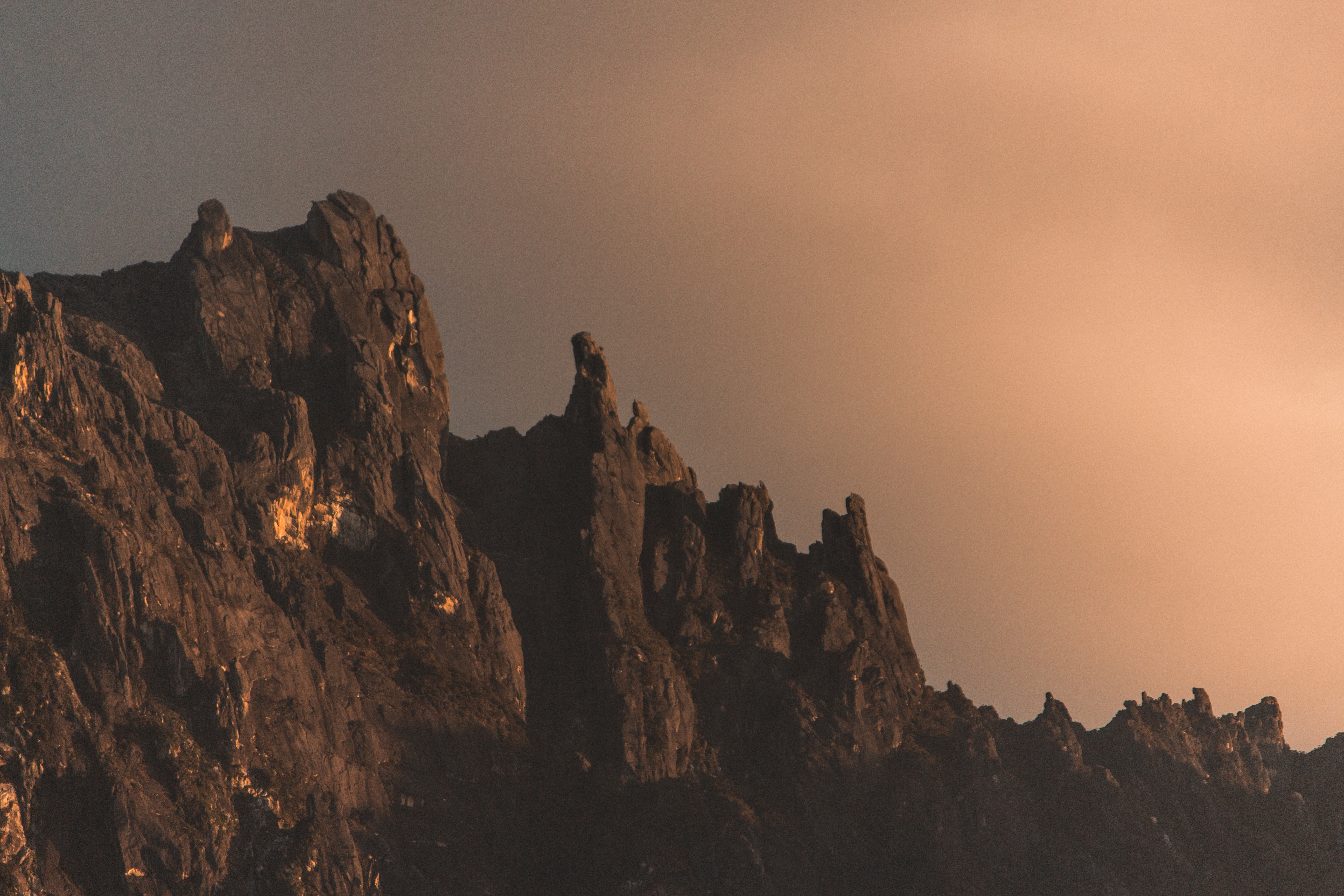
The present landform is considered to be a mid-Pliocene peneplain, arched and deeply dissected, through which the Kinabalu granodiorite body has risen in isostatic adjustment. It is still pushing up at the rate of 5 mm (0.20 in) per annum. During the Pleistocene Epoch of about 100,000 years ago, the massive mountain was covered by huge sheets of ice and glaciers which flowed down its slopes, scouring its surface in the process and creating the 1,800 m (5,906 ft) deep Low's Gully (named after Hugh Low) on its north side. Its granitic composition and the glacial formative processes are readily apparent when viewing its craggy rocky peaks.[1]
History
British colonial administrator Hugh Low made the first recorded ascent of Mount Kinabalu's summit plateau in March 1851 with local Dusun guide Lemaing of Kampung Kiau. Low did not scale the mountain's highest peak, however, considering it "inaccessible to any but winged animals".[20] In April and July 1858, Low was accompanied on two further ascents by Spenser St. John, the British Consul in Brunei.[1] The highest point of Mount Kinabalu was finally reached in 1888 by zoologist John Whitehead.[1] British botanist Lilian Gibbs became the first woman and the first botanist to summit Mount Kinabalu in February 1910.[1]
Botanist E. J. H. Corner led two important expeditions of the Royal Society of Great Britain to the mountain in 1961 and 1964.[1] Kinabalu National Park was established in 1964. The park was designated a natural World Heritage Site in 2000.[21]
2015 earthquake
On 5 June 2015 at 07:15 MST, the area around Mount Kinabalu was damaged by an earthquake. Eighteen people, including hikers and mountain guides, were killed by the earthquake and a massive landslide that followed it. Ranau and many parts of Sabah West Coast were affected and Donkey Ear's Peak was heavily damaged.[22]
Six days before the earthquake, around ten western tourists (comprising six men and four women from Canada, Germany, Netherlands and the United Kingdom)[23] "stripped and urinated at the mountain (which locals believe has angered the spirit at the sacred place)".[24] The tourists also allegedly shouted vulgarities when they were told to desist by their mountain guide,[25][26] but this was later dismissed by the judge in their trial.[citation needed] This provoked outrage among certain Sabahans, who want all of the alleged offenders charged in native court and forced to pay the "sogit", a type of compensation, given in the form of money or livestock, to appease the aggrieved party according to local Kadazan-Dusun customs. It is imposed on wrongdoers for the purpose of appeasing "the aggrieved", thus placating the community.[27] However, as most of the detained tourists have been released from Malaysia's prison and escaping native court, the local villagers had to perform their own rituals.[28] Following the incident, some of the tourists and their families have expressed their apologies to all involved parties, and the government of the United Kingdom began to review its travel advice for Malaysia.[29][30]
Climbing permit
Sabah Parks grants a summit-climbing permit only to climbers who stay at mountain huts. Due to the limited number of beds at the mountain huts, only 130 people are allowed to climb Mount Kinabalu per day.
Climbing route
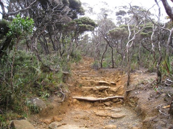

Climbers must be accompanied by accredited guides at all times due to national park regulations. There are two main starting points for the climb: the Timpohon Gate (located 5.5 km (3.4 mi) from Kinabalu Park Headquarters, at an altitude of 1,866 m (6,122 ft)),[31] and the Mesilau Nature Resort. The latter starting point is slightly higher in elevation, but crosses a ridge, adding about two kilometres to the ascent and making the total elevation gain slightly higher. The Mesilau Trail is no longer accessible due to the earthquake in 2015. The two trails meet about 2 km (1.2 mi) before Laban Rata.
Accommodation is available inside the park or outside near the headquarters. Sabah Parks has privatised Mount Kinabalu activities to an organisation called Sutera Sanctuary Lodges. The mountain may be climbed on a single day trip, or hikers may (usually) stay one night at Laban Rata Resthouse at 3,270 m (10,730 ft) to complete the climb in 2 days, finishing the ascent and descending on the second day. The majority of climbers begin the ascent on day one of a two-day hike from Timpohon gate at 1,866 m (6,122 ft), reaching this location either by minibus or by walking, and then walk to Laban Rata. Most people accomplish this part of the climb in 3 to 6 hours. Since there are no roads, the supplies for the Laban Rata Resthouse are carried by porters, who sometimes bring more than 35 kg (77 lb) of supplies on their backs. Hot food and beverages are available at Laban Rata. Most rooms have no hot water in the bathrooms and whilst the dining area is heated, most rooms are not. The last 2 km (6,600 ft), from the Laban Rata Resthouse at 3,270 m (10,730 ft) to Low's Peak (summit) at 4,095.2 m (13,436 ft), takes between 2 and 4 hours. The last part of the climb is on bare granite rock.
Given the high altitude, some people may suffer from altitude sickness[32] although staying overnight at the lodges before the climb and climbing at a lower rate of ascent may reduce the likelihood of this happening.
Low's Gully
Low's Gully (named after Hugh Low who first looked down into it in 1851) is a 1,800 m (5,906 ft) deep gorge carved out by glaciation on the north side of Mount Kinabalu, which is exceptionally inhospitable due to its depth and high rainfall. In March 1994 two British Army officers were severely criticised after leading a party of 7 British and 3 Hong Kong soldiers in an attempt to abseil and climb down into the gully that required extensive rescue efforts from both the RAF and the Malaysian army. The party were not equipped with radios and the 2 officers and 3 Hong Kong soldiers were trapped for 16 days and did not eat for five days before being rescued when stretchers were lowered by helicopter. The breakaway party of five completed the first descent of the gully in three days.[33] A book about the 31-day fight for survival entitled Descent into Chaos was published in 1996 and a film drama The Place of the Dead was released in 1997. The first successful complete descent of Low's Gully was achieved by a 27 strong joint Malaysian-British team led by mountaineer and former British Army officer Pat Gunson in 1998.[34][35][36]
Naming myths


This section may require cleanup to meet Wikipedia's quality standards. The specific problem is: Poor English, needs rewriting by fluent speaker. (December 2020) |
There are a few stories that led to the main beliefs in the origin of the mountain's name.
The first derivation of the word Kinabalu is extracted from the short form for the Kadazan-Dusun word 'Aki Nabalu', meaning "the revered place of the dead". [citation needed] Meanwhile, it can also be believed that the name "Kinabalu" comes from the Dusun phrase "tina balu" which means "a widow mother". So, assumably, tina balu is the spirit of the mount itself. [citation needed] Another consideration is Kinabalu is formed by two words of Dusun "ki" (have/has) and "nabalu" (mountain), so "ki-nabalu" means "have mountain". It is common for Dusun people to name places based on what the place has. For example, there is a place named "kiwaig" that literally means "have water". Considering the fact that the word "Kinabalu" in many Dusun dialects literally means 'mountain', this explanation is most likely.[citation needed]
A popular story told to Western and Chinese tourists states that the name "Kinabalu" actually means "Cina Balu" (meaning "A Chinese Widow").[37] Due to the lingual influence among the Kadazan Dusun of Sabah, the pronunciation for the word "cina" (chee-na) was changed to "Kina" (kee-na).[38] An earlier book by Spenser St. John published in 1863 mentioned the Kina Balu (Chinese widow) as a reference to the mountain.[39]
It was told that a Chinese prince was cast away to Borneo when his ship sank in the middle of the South China Sea. He was subsequently rescued by the natives from a nearby village. As he recovered, he was slowly accepted as one of the people of the village. Eventually, he fell in love with a local woman and married her. Years went by and he started to feel homesick. So he asked permission from his new family to go back to China to visit his parents (the Emperor and Empress of China). To his wife, he promised that as soon as he was done with his family duties in China, he would come back to Borneo to take her and their children back to China. When he made his return to China, he was given a grand welcome by his family. However, to his dismay, his parents disapproved of him bringing his Bornean wife to China. Worse, they told him that he was already betrothed to a princess of a neighbouring kingdom. Having no choice (due to high respect towards his parents), he obeyed with a heavy heart.
Meanwhile, back in Borneo, his wife grew more and more anxious. Eventually, she decided that she would wait for her husband's ship. However, since the village was situated far away from the coast, she couldn't afford to come to the shore and wait for him daily. Instead, she decided to climb to the top of the highest mountain near her village, so that she could have a better view of the ships sailing in the South China Sea. Thus, she was then seen climbing up the mountain at every sunrise, returning only at night to attend to her growing children. Eventually her efforts took their toll. She fell ill, and died at the top of the cold mountain while waiting for her husband. The spirit of the mountain, having observed her for years, was extremely touched by her loyalty towards her husband. Out of admiration for this woman, the spirit of the mountain turned her into a stone.[37] Her face was made to face the South China Sea, so that she could wait forever for her dear husband's return. The people in her hometown who heard about this were also gravely touched by this. Thus, they decided to name the mountain "Kinabalu" in remembrance of her. To them, the mountain is a symbol of the everlasting love and loyalty that should be taken as a good example by women.[citation needed]
Local legend among the people of Ranau, a district in Sabah, has it that St. John's Peak was the stone which her body was turned into.

Temperature
The temperature of Mount Kinabalu usually stands from −4 to 8 °C (25 to 46 °F) from December to January, and 3 to 12 °C (37 to 54 °F) from June to September. Due to the coldness of the mountain from December to January, there are a few occasions where frost and ice appear at the summit of Mount Kinabalu.[40][41] [42] There was also snow thrice in this area; in 1975, 1993 and 2022. [43]
See also
- Borneo lowland rain forest – ecoregion
- Borneo montane rain forests – ecoregion
- Backpacking
- Mount Kinabalu International Climbathon
References
- Phillipps, A. & F. Liew 2000. Globetrotter Visitor's Guide – Kinabalu Park. New Holland Publishers (UK) Ltd.
- "Kinabalu Park". UNESCO World Heritage Centre. Archived from the original on 14 June 2015. Retrieved 7 June 2015.
- Michael Aquino. "Mount Kinabalu, Malaysia". About.com Travel. Archived from the original on 4 April 2015. Retrieved 7 June 2015.
- "Mount Kinabalu – revered abode of the dead". Ecology Asia. Archived from the original on 21 September 2010. Retrieved 7 June 2015.
- Simon Richmond (2010). Malaysia, Singapore & Brunei. Lonely Planet. pp. 360–. ISBN 978-1-74104-887-2. Archived from the original on 29 June 2016. Retrieved 16 December 2015.
- Parris, By. S., R. S. Beaman, and J. H. Beaman. 1992. The Plants of Mount Kinabalu: 1. Ferns and Fern Allies. Kew: Royal Botanic Gardens. 165 pp + 5 pl.
- Wood, J. J., J. H. Beaman, and R. S. Beaman. 1993. The Plants of Mount Kinabalu. 2. Orchids. Kew: Royal Botanic Gardens. xii + 411 pp + 84 pl.
- Beaman, J. H., and R. S. Beaman. 1998. The Plants of Mount Kinabalu. 3. Gymnosperms and Non-Orchid Monocotyledons. Kota Kinabalu: Natural History Publications (Borneo) Sdn. Bhd.; Kew: Royal Botanic Gardens. xii + 220 pp + 25 pl.
- Beaman, J. H., C. Anderson, and R. S. Beaman. 2001. The plants of Mount Kinabalu. 4: Dicotyledon families Acanthaceae to Lythraceae. xiv + 570 pp + 45 pl. Kota Kinabalu: Natural History Publications (Borneo) Sdn. Bhd.; Kew: Royal Botanic Gardens.
- Beaman, J. H., and C. Anderson. 2004. The plants of Mount Kinabalu. 5: Dicotyledon families Magnoliaceae to Winteraceae. xiv + 609 pp + 40 pl. Kota Kinabalu: Natural History Publications (Borneo) Sdn. Bhd.; Kew: Royal Botanic Gardens.
- Miguel Camacho-Sanchez, Irene Quintanilla, Melissa T. R. Hawkins, Fred Y. Y. Tuh, Konstans Wells, Jesus E. Maldonado and Jennifer A. Leonard. 2018. "Interglacial refugia on tropical mountains: novel insights from the summit rat (Rattus baluensis), a Borneo mountain endemic". Diversity and Distributions, 24: 1252–1266. https://doi.org/10.1111/ddi.12761 Archived 2 December 2021 at the Wayback Machine
- Merckx, V. S. F. T.; Hendriks, K. P.; Beentjes, K. K.; Mennes, C. B.; Becking, L. E.; Peijnenburg, K. T. C. A.; Afendy, A.; Arumugam, N.; de Boer, H.; Biun, A.; Buang, M. M.; Chen, P.-P.; Chung, A. Y. C.; Dow, R.; Feijen, F. A. A.; Feijen, H.; Feijen-van Soest, C; Geml, J.; Geurts, R.; Gravendeel, B.; Hovenkamp, P.; Imbun, P.; Ipor, I.; Janssens, S. B.; Jocqué, M.; Kappes, H.; Khoo, E.; Koomen, P.; Lens, F.; Majapun, R. J.; Morgado, L. N.; Neupane, S.; Nieser, N.; Pereira, J. T.; Rahman, H.; Sabran, S.; Sawang, A.; Schwallier, R. M.; Shim, P.-S.; Smit, H.; Sol, N.; Spait, M.; Stech, M.; Stokvis, F.; Sugau, J. B.; Suleiman, M.; Sumail, S.; Thomas, D. C.; van Tol, J.; Tuh, F. Y. Y.; Yahya, B. E.; Nais, J.; Repin, R.; Lakim, M.; Schilthuizen, M. (2015). "Evolution of endemism on a young tropical mountain" (PDF). Nature. 524 (7565): 347–350. Bibcode:2015Natur.524..347M. doi:10.1038/nature14949. PMID 26266979. S2CID 4447746. Archived (PDF) from the original on 23 July 2018. Retrieved 3 June 2019.
- Kurata, S. 1976. Nepenthes of Mount Kinabalu. Sabah National Parks Publications No. 2, Sabah National Parks Trustees, Kota Kinabalu.
- Adam, J.H.; Wilcock, C.C. (1998). "Pitcher plants of Mt. Kinabalu in Sabah". The Sarawak Museum Journal. 50 (71): 145–171.
- Camacho-Sanchez M, Hawkins MTR, Tuh Yit Yu F, Maldonado JE, Leonard JA. 2019. Endemism and diversity of small mammals along two neighboring Bornean mountains. PeerJ 7:e7858 https://doi.org/10.7717/peerj.7858 Archived 2 December 2021 at the Wayback Machine
- Blakemore, R.J.; C. Csuzdi; M.T. Ito; N. Kaneko; T. Kawaguchi; M. Schilthuizen (2007). "Taxonomic status and ecology of Oriental Pheretima darnleiensis (Fletcher, 1886) and other earthworms (Oligochaeta: Megascolecidae) from Mt Kinabalu, Borneo" (PDF). Zootaxa. 1613: 23–44. doi:10.11646/zootaxa.1613.1.2. Archived (PDF) from the original on 10 April 2008. Retrieved 31 December 2007.
- Liew, T.S.; Schilthuizen, M. (2010). "The determinants of land snail diversity along a tropical altitudinal gradient: insularity, geometry, and niches". Journal of Biogeography. 37: 1071–1078. doi:10.1111/j.1365-2699.2009.02243.x. S2CID 83558264.
- "Expedition investigates origin of unique species on Borneo". Press release. Naturalis Biodiversity Center. Archived from the original on 23 July 2015.
- "Kinabalu montane alpine meadows". Terrestrial Ecoregions. World Wildlife Fund.
- Hiung, C. S., R. Mandalam, and C. Chin. 2004. The Hugh Low Trail: The Quest for the Historical Trail to the Summit of Kinabalu. The Sabah Society, Kota Kinabalu.
- Kinabalu Park Archived 20 May 2016 at the Wayback Machine. UNESCO World Heritage Centre.
- Victoria Brown (5 June 2015). "Sabah quake: Donkey's Ear Peak on Mount Kinabalu destroyed". The Star. Archived from the original on 7 June 2015. Retrieved 7 June 2015.
- Hannah Strange (10 June 2015). "British woman arrested in Malaysia over nude photos in Mount Kinabalu". The Daily Telegraph. Archived from the original on 10 June 2015. Retrieved 11 June 2015.
- Michelle Tam; Stephanie Lee (5 June 2015). "Sabah quake: Mount Kinabalu may be "angry" with nudists, say locals". The Star. Archived from the original on 7 June 2015. Retrieved 7 June 2015.
- Julia Chan (2 June 2015). "Warned not to strip, naked tourists allegedly told guide to 'go to hell'". The Malay Mail. Archived from the original on 6 June 2015. Retrieved 11 June 2015.
- Natasha Joibi (8 June 2015). "Sabah quake: Nude tourists shouted vulgarities at mountain guide". The Star. Archived from the original on 10 June 2015. Retrieved 11 June 2015.
- "Sabahans want 10 foreign stripper tourists charged in native court". Daily Express. 10 June 2015. Archived from the original on 10 June 2015. Retrieved 10 June 2015.
- "Five villages perform own rituals: Chief After unable to impose 'sogit' on nudists". Daily Express. 20 June 2015. Archived from the original on 22 June 2015. Retrieved 22 June 2015.
- Matthew Weaver; Beh Lih Yi (11 June 2015). "Mount Kinabalu 'naked prank': UK reviews advice for travellers to Malaysia". The Guardian. Archived from the original on 12 June 2015. Retrieved 12 June 2015.
- "Sask. siblings apologize for posing naked on Malaysia mountain". Canadian Broadcasting Corporation. 16 June 2015. Archived from the original on 15 September 2020. Retrieved 17 June 2015.
- Quentin Phillipps; Karen Phillipps (10 May 2016). Phillipps' Field Guide to the Mammals of Borneo and Their Ecology: Sabah, Sarawak, Brunei, and Kalimantan. Princeton University Press. pp. 236–. ISBN 978-0-691-16941-5.
- Cymerman, A; Rock, PB. "Medical Problems in High Mountain Environments. A Handbook for Medical Officers". USARIEM-TN94-2. US Army Research Inst. of Environmental Medicine Thermal and Mountain Medicine Division Technical Report. Archived from the original on 23 April 2009. Retrieved 5 March 2009.
{{cite journal}}: Cite journal requires|journal=(help)CS1 maint: unfit URL (link) - Mary Braid (20 September 1994). "Leaders of lost expedition criticised". The Independent. Archived from the original on 27 June 2015. Retrieved 7 June 2015.
- "Pat Wins His Battle With Low's Gully". The Westmorland Gazette. 1 January 2000. Archived from the original on 27 June 2015. Retrieved 15 June 2015.
- "British climbers prepare to tame Low's Gully". BBC News. 12 January 1998. Archived from the original on 22 October 2002. Retrieved 16 June 2015.
- Kvinta, Paul (1 March 2003). "Big Gulp, No Exit". Outside. Archived from the original on 14 February 2021. Retrieved 8 February 2021.
- "The call of Malaysia's 'conquerable' Mount Kinabalu". BBC News. 5 June 2015. Archived from the original on 28 July 2021. Retrieved 19 June 2017.
- Alan Rogers (18 January 2015). "Majesty, mystery and magic of mountains". The Borneo Post. Archived from the original on 21 September 2017. Retrieved 19 June 2017.
- Sir Spenser St. John (1863). Life in the Forests of the Far East. Smith, Elder and Company. p. 327. Archived from the original on 2 December 2021. Retrieved 20 June 2019.
- "Did it snow on the summit of Mount Kinabalu?". The Star. 25 January 2014. Archived from the original on 10 June 2017. Retrieved 19 June 2017.
- Tang Ruxyn (10 February 2017). "Ice Sheets And 'Snow' Have Formed on Mount Kinabalu!". Says.com. Archived from the original on 28 July 2017. Retrieved 19 June 2017.
- "Gunung Kinabalu pernah diselebungi salji". /SBH. 12 February 2017. Retrieved 14 July 2019.
- "Does It Snow in Malaysia?". 31 May 2021.
Further reading
- Thomas Fuller (9 April 1999). Into the Mists of Borneo's Kinabalu Archived 2 December 2021 at the Wayback Machine. The New York Times.
- Hugh; Midori Paxton (7 March 2001). Climb rain forests to the clouds Archived 8 January 2019 at the Wayback Machine. The Japan Times.
- Jim Solicki (23 June 2001). They came, they climbed: Mount Kinabalu conquered Archived 6 December 2019 at the Wayback Machine. The Globe and Mail.
- Jocasta Webb (1 September 2001). The truth about Mount Kinabalu Archived 27 May 2016 at the Wayback Machine. The Guardian
- Flip Byrnes (18 August 2010). Least-known, most exhilarating hikes Archived 2 December 2021 at the Wayback Machine. Stuff.co.nz
- Niall McIlroy (9 July 2011). Man versus mountain Archived 6 December 2019 at the Wayback Machine. The West Australian.
- Gabby Salazar (2 June 2014). Sunrise Hiking on Mount Kinabalu Archived 1 August 2017 at the Wayback Machine. National Geographic
- Sasha Gonzales (14 April 2015). 'If hell were a mountain, it would look like Mount Kinabalu': a Hong Kong hiker's Borneo blues Archived 2 December 2021 at the Wayback Machine. South China Morning Post
- Amy Willis (11 June 2015). What are the rules on climbing Mount Kinabalu and why is it so sacred? Archived 12 October 2017 at the Wayback Machine. Metro.
External links
 Mount Kinabalu travel guide from Wikivoyage
- Sabah Parks website
- List of climbers who have hiked Mount Kinabalu
На других языках
[de] Kinabalu
Der Kinabalu, Gunung Kinabalu (mal. Gunung = „Berg“) oder Mount Kinabalu ist der höchste Berg Malaysias. Er ist 4095 m hoch und liegt im malaysischen Bundesstaat Sabah, im Nordteil Borneos. Er ist etwa 50 km von Kota Kinabalu, der Hauptstadt des Staates, entfernt.- [en] Mount Kinabalu
[es] Monte Kinabalu
El monte Kinabalu (en malayo Gunung Kinabalu) es una destacada montaña de Malasia, en el Sudeste Asiático. Se encuentra en el parque nacional de Kinabalu (declarado Patrimonio de la Humanidad en 2000) en el estado de Sabah situado en Malasia Oriental, que ocupa la zona septentrional de Borneo, en el trópico. Es la mayor montaña de Insulindia. Tiene una altura de 4095 m s. n. m..[1][fr] Mont Kinabalu
Le mont Kinabalu, en malais Gunung Kinabalu, est une montagne de Malaisie, point culminant de ce pays et de l'île de Bornéo avec 4 095 mètres d'altitude. Sa grande biodiversité est rendue possible par une géologie et un climat uniques. Elle comprend de nombreuses espèces endémiques, notamment plusieurs plantes carnivores ainsi que de nombreuses orchidées, protégées par le parc national du Kinabalu. Cette richesse a été découverte par Hugh Low et John Whitehead au milieu du XIXe siècle, ce dernier étant l'auteur de la première ascension de la cime principale en 1888. Il s'agit de l'une des montagnes les plus fréquentées d'Asie du Sud-Est.[it] Monte Kinabalu
Il Kinabalu, in malese Gunung Kinabalu, è una montagna della Malaysia, punto culminante del paese e dell'isola del Borneo con i suoi 4095 metri di altitudine. La geologia e il clima unici hanno reso possibile lo sviluppo di una grande biodiversità, che comprende numerose specie endemiche, in particolare di piante carnivore e di orchidee, protette all'interno del parco nazionale del Kinabalu. Tale ricchezza floristica venne scoperta intorno alla metà del XIX secolo da Hugh Low e John Whitehead, l'ultimo dei quali sarà anche il primo a raggiungerne la vetta nel 1888. È una delle montagne più frequentate dai turisti di tutto il Sud-est asiatico.[ru] Кинабалу
Кинаба́лу (малайск. Gunung Kinabalu) — четвёртая по высоте гора в Юго-Восточной Азии, высота — 4095[2][3] метров. Расположена на территории национального парка Кинабалу (входит в список Всемирного наследия ЮНЕСКО) на востоке Малайзии в штате Сабах, расположенного на острове Калимантан, среди тропических джунглей.Другой контент может иметь иную лицензию. Перед использованием материалов сайта WikiSort.org внимательно изучите правила лицензирования конкретных элементов наполнения сайта.
WikiSort.org - проект по пересортировке и дополнению контента Википедии