geo.wikisort.org - Mountains
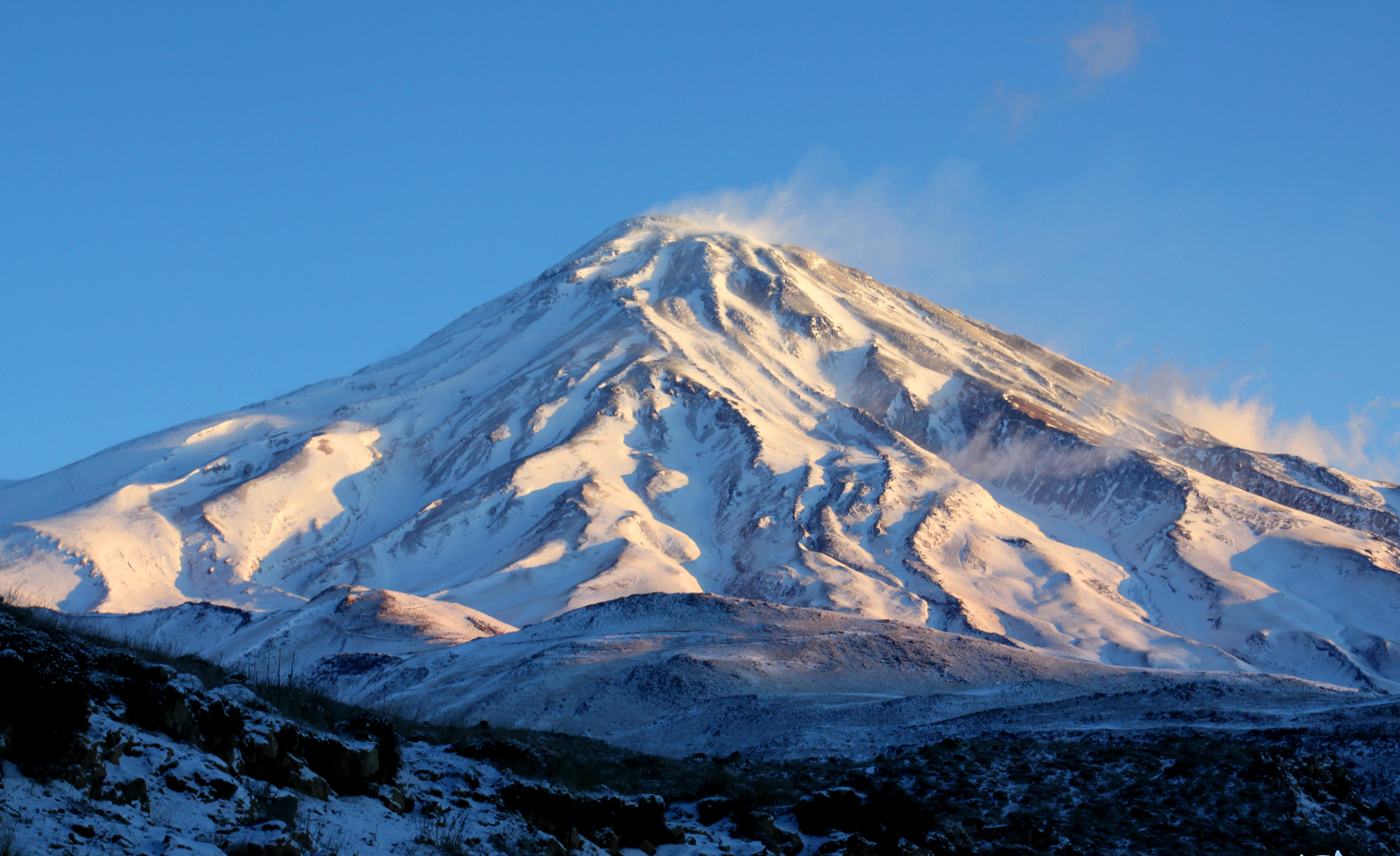
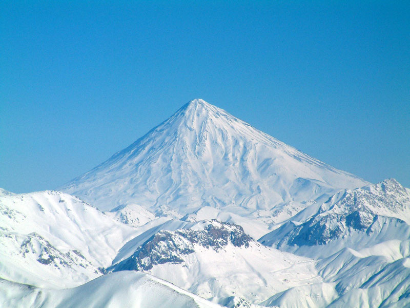
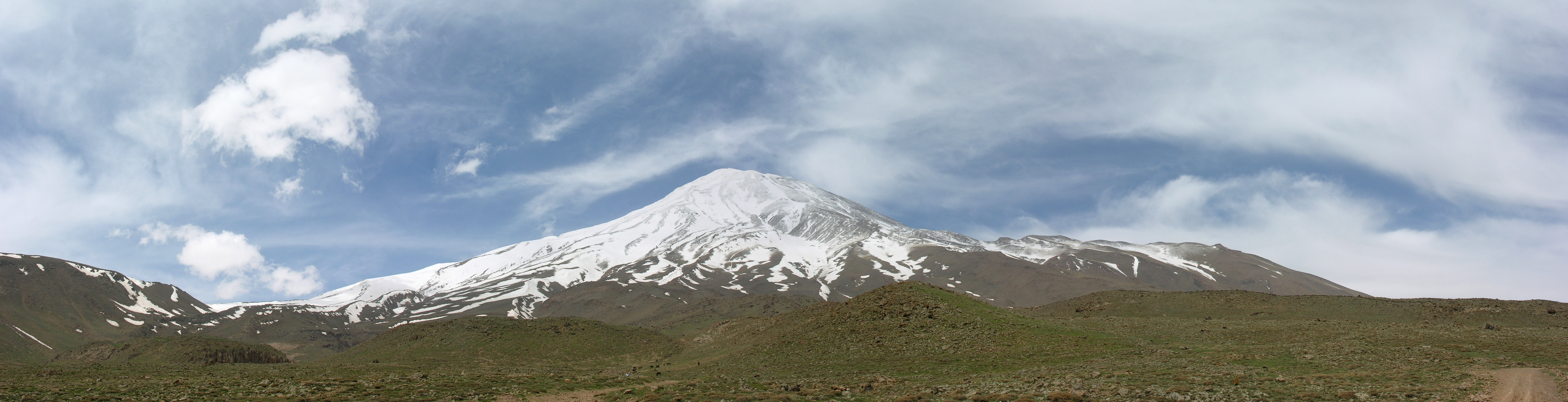
Mount Damavand (Persian: دماوند [dæmɒːvænd] (![]() listen)) is a potentially active stratovolcano, the highest peak in Iran and Western Asia and the highest volcano in Asia and the 2nd highest volcano in the Eastern Hemisphere (after Mount Kilimanjaro), at an elevation of 5,671 metres (18,606 ft).[7][8][lower-alpha 1] Damāvand has a special place in Persian mythology and folklore. It is in the middle of the Alborz range, adjacent to Varārū, Sesang, Gol-e Zard, and Mīānrūd. It is near the southern coast of the Caspian Sea, in Amol County, Mazandaran Province, 66 km (41 mi) northeast of the city of Tehran.[9]
listen)) is a potentially active stratovolcano, the highest peak in Iran and Western Asia and the highest volcano in Asia and the 2nd highest volcano in the Eastern Hemisphere (after Mount Kilimanjaro), at an elevation of 5,671 metres (18,606 ft).[7][8][lower-alpha 1] Damāvand has a special place in Persian mythology and folklore. It is in the middle of the Alborz range, adjacent to Varārū, Sesang, Gol-e Zard, and Mīānrūd. It is near the southern coast of the Caspian Sea, in Amol County, Mazandaran Province, 66 km (41 mi) northeast of the city of Tehran.[9]
| Damavand دماوند | |
|---|---|
 Mount Damavand, the south side, Mazandaran province, Iran | |
| Highest point | |
| Elevation | 5,671 m (18,606 ft)[1][2][disputed ][3] |
| Prominence | 4,667 m (15,312 ft)[2][4] Ranked 12th |
| Parent peak | Mount Elbrus[5] |
| Isolation | 1,165 km (724 mi) |
| Listing | Volcanic Seven Summits Country high point Ultra |
| Coordinates | 35°57′20″N 52°06′36″E[4] |
| Geography | |
 Damavand دماوند Location in Iran | |
| Location | Amol, Māzandarān, Iran |
| Parent range | Alborz – Mazandaran |
| Geology | |
| Mountain type | Stratovolcano |
| Last eruption | 5350 BC ± 200 years |
| Climbing | |
| First ascent | 905 by Abu Dolaf Kazraji[6] |
| Easiest route | Hike |

Mount Damāvand is the 12th most prominent peak in the world and the second most prominent in Asia after Mount Everest. It is part of the Volcanic Seven Summits mountaineering challenge.
Symbolism and mythology
Damavand is a significant mountain in Persian mythology. It is the symbol of Iranian resistance against despotism and foreign rule in Persian poetry and literature. In Zoroastrian texts and mythology, the three-headed dragon Aži Dahāka was chained within Mount Damāvand, there to remain until the end of the world. In a later version of the same legend, the tyrant Zahhāk was also chained in a cave somewhere in Mount Damāvand after being defeated by Kāveh and Fereydūn. Persian poet Ferdowsi depicts this event in his masterpiece, the Shahnameh:
بیاورد ضحاک را چون نَوَند
به کوه دماوند کردش بهبند biyāvarad Zahhāk rā čon navand
be kuh-e Damāvand kardaš be-bandHe brought Zahhak like a horse to mount Damavand,
And tied him at the peak tight and bound.
The mountain is said to hold magical powers in the Shahnameh. Damāvand has also been named in the Iranian legend of Arash (as recounted by Bal'ami) as the location from which the hero shot his magical arrow to mark the border of Iran, during the border dispute between Iran and Turan. The poem Damāvand by Mohammad Taqī Bahār is also one fine example of the mountain's significance in Persian literature. The first verse of this poem reads:
ای دیو سپید پای در بند
ای گنبد گیتی، ای دماوند ey div-e sepid-e pāy dar band,
Ey gonbad-e giti, ey DamāvandO white giant with feet in chains,
O dome of the world, O Damāvand.
Mount Damavand is depicted on the reverse of the Iranian 10,000 rial banknote.[10]
The origins and meaning of the word "Damavand" is unclear, yet some prominent researchers[who?] have speculated that it probably means "The mountain from which smoke and ash arises", alluding to the volcanic nature of the mountain.[citation needed]

Geology
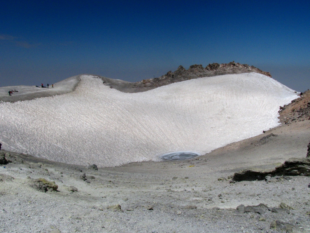
Mount Damavand first erupted in the Pleistocene almost 1.78 million years ago. After several known eruptions around 600,000 and 280,000 years ago, its last eruption was around 5300 BC in the Holocene. Its steep cone is formed of ash and lava flows mainly of trachyte, andesite, and basalt. The Quaternary lavas are directly on the Jurassic sediments.[11] The volcano is crowned by a small crater with sulfuric deposits. There are also fumaroles, hot springs, and mineral deposits of travertine. Mount Damavand could be considered as a potentially active volcano,[12] because there are fumaroles near the summit crater emitting sulfur, which was known to be active on July 6, 2007.[13]
Thermal springs
Mineral hot springs are mainly located on the volcano's flanks and at the base, giving evidence of volcanic heat comparatively near the surface of the earth. While no historic eruptions have been recorded, hot springs at the base and on the flanks, and fumaroles and solfatara near the summit, indicate a hot or cooling magma body still present beneath the volcano.
The most important of these hot springs are located in Abe Garm Larijan in a village by the name Larijan in the district of Larijan in Lar Valley. The water from this spring is useful in the treatment of chronic wounds and skin diseases. Near these springs there are public baths with small pools for public use.
Routes to the summit
A major settlement for mountain climbers is the new Iranian Mountain Federation Camp in the village of Polour, located on the south of the mountain.
There are at least 16 known routes[14] to the summit, with varying levels of difficulty. Some of them are dangerous and require ice climbing. The most popular route is the southern route which has steps and a camp midway called Bargah Sevom Camp/Shelter[15] at 4,220 m (13,850 ft). The Northeastern route is the longest and requires two days to reach the summit starting from the downhill village of Nāndal and a night stay at Takht-e Fereydoun (elevation 4,300 m (14,100 ft), a two-story shelter. The western route is noted for its sunset view. Simurgh (Sīmorgh/Sīmurgh) shelter in this route at 4,100 m (13,500 ft) is a newly constructed two-story shelter. There is a frozen waterfall/icefall[16] (Persian name Ābshār Yakhī) about 12 m (39 ft) tall whose elevation of 5,100 m (16,700 ft) makes it the highest fall in Iran and the Middle East.[citation needed]
Geographical location
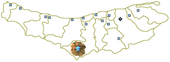
| Map of central Alborz | Peaks: | 1 Alam-Kuh |
|---|---|---|
 −25 to 500 m (−82 to 1,640 ft) 500 to 1,500 m (1,600 to 4,900 ft) 1,500 to 2,500 m (4,900 to 8,200 ft) 2,500 to 3,500 m (8,200 to 11,500 ft) 3,500 to 4,500 m (11,500 to 14,800 ft) 4,500 to 5,610 m (14,760 to 18,410 ft) |
2 Azad Kuh | 3 Damavand |
| 4 Do Berar | 5 Do Khaharan | |
| 6 Ghal'eh Gardan | 7 Gorg | |
| 8 Kholeno | 9 Mehr Chal | |
| 10 Mishineh Marg | 11 Naz | |
| 12 Shah Alborz | 13 Sialan | |
| 14 Tochal | 15 Varavašt | |
| Rivers: | 0 | |
| 1 Alamut | 2 Chalus | |
| 3 Do Hezar | 4 Haraz | |
| 5 Jajrood | 6 Karaj | |
| 7 Kojoor | 8 Lar | |
| 9 Noor | 10 Sardab | |
| 11 Seh Hazar | 12 Shahrood | |
| Cities: | 1 Amol | |
| 2 Chalus | 3 Karaj | |
| Other: | D Dizin | |
| E Emamzadeh Hashem | K Kandovan Tunnel | |
| * Latyan Dam | ** Lar Dam |
Wildlife
Fish
Damavand rivers and slopes are famous for brown trout (Salmo trutta).[17][18]
Mammals
Armenian mouflon (Ovis orientalis) and wild goat (Capra aegagrus) live in the region of Damavand Mts. Persian leopard (Panthera pardus saxicolor) and Syrian brown bear (Ursus arctos syriacus) also inhabit in this region. Smaller mammals include the snow vole (Chionomys nivalis), mouse-like hamster (Calomyscus bailwardi) and Afghan pika (Ochoton rufescens).[19][20][21]
Birds
The attractive and unreachable Caspian snowcock (Tetraogallus caspius) lives at high altitudes. Golden eagle (Aquila chrysaetos) breeds in this area. Griffon vultures (Gyps fulvus) are common. Chukar partridge (Alectoris chukar) has a high population and nests between stone and shrubs. Red-fronted serin (Serinus pusillus), linnet (Carduelis cannabina), snow finch (Montifringilla nivalis), rock sparrow (Petronia petronia), rock bunting (Emberiza cia) and horned lark (Eremophila alpestris) are native; in winter they come to the lower hillsides. In spring northern wheatear (Oenanthe oenanthe), rock thrush (Monticola saxatilis), and nightingale (Luscinia megarhynchos) come from Africa for breeding. Grey-necked bunting (Emberiza buchanani), black-headed bunting (Emberiza melanocephala) and common rosefinch (Carpodacus erythrinus) come from India.[22]
Reptiles and amphibians
Marsh frogs (Rana ridibunda) live in Lar riversides. Meadow viper (Vipera ursinii), blunt-nosed viper (Macrovipera lebetina), Iranian valley viper (Vipera latifii) and Caucasian agama (Laudakia caucasia) are among the reptiles of this mountainous region.[23][24]
Flora

On the southern slope of Damavand, there are remnants of wild pistachia trees (Pistacia atlantica). Along its riversides different kinds of Salix trees like willow (Salix acomphylla) and oleaster (Elaeagnus angustifolia) are found. Greek juniper (Juniperus excelsa) is common in the higher altitudes. On northern slopes, because of higher humidity, there are wild oak, beech, hornbean and hazel trees like: Persian oak (Quercus macranthera), Oriental beech (Fagus orientalis), Eastern hornbeam (Carpinus orientalis), and Turkish hazel (Corylus colurna).[25] There are also many wild flowers such as mountain tulip (Tulipa montana) and Persian stone cress (Aethionema grandiflorum). At higher altitudes, shrubs tend to be sphere and cushion like, examples are : Astragalus species (Astragalus microcephalus), mountain sainfoin (Onobrychis cornuta) and prickly (Acantholimon erinaceum). Different kinds of grasses complete this alpine scene.[26] Iris barnumiae demawendica (formerly Iris demawendica), is found and named after the mountain.[27][28]
From mid-May to mid-June the foothills of Damavand are covered in red poppies. This unique type of poppy, growing in areas between 2,000 and 3,500 metres, is referred to in botany books as the Lar poppy or Rineh poppy (Rineh and Lar are villages in the foothills of Damavand).
National Heritage Site
An anthropologist of Mazandaran Cultural Heritage and Tourism Department, Touba Osanlou, has said that a proposal has been made by a group of Iranian mountaineers to register the highest peak in the Middle East, Mount Damavand as a national heritage site. Mazandaran Cultural Heritage and Tourism Department has accepted the proposal, the Persian daily Jam-e Jam reported. Osanlou noted that the Iranian Cultural Heritage and Tourism Organization is presently in the process of renaming an upcoming ancient festivity after Mount Damavand. "We have proposed Tirgan Festivity, Tabari Nowruz, to be named as Damavand National Day," she added. Tirgan Festivity is held in Amol County's Rineh region in Mazandaran province.[29]
Gallery
 Damavand Summit, Mazandaran Province, Iran, August 2020
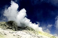 Sulfurous gasses issuing from a fumarole near the summit of Damavand, August 16, 2018
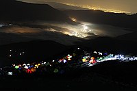 Base camp, the third court (4250m), Damavand mountain, the south face, August 15, 2018
 Damavand mountain, the west side, view from Tochal summit, Tehran, Iran
 Damavand summit in winter, view from Dizin
 Specimen of native Sulphur from the summit of Damavand, indicative of volcanism
 Mount Damavand on the reverse of a 1938 1000 Iranian Rial banknote


See also
- Tirgan
- List of mountains in Iran
- List of peaks by prominence
- List of Ultras of West Asia
- List of volcanoes in Iran
- Lists of volcanoes
- Maranak
- Volcanic Seven Summits
Explanatory notes
- The Kunlun Volcanic Group in Tibet is higher than Damāvand, but are not considered to be volcanic mountains.
References
- Geography of Iran Archived 2015-01-17 at the Wayback Machine
- "Kuh-e Damavand" – Iran Ultra Prominence peaklist.org. Retrieved 16 October 2011
- 2009 U.S. military topographic mapping gives 18,365 feet (5,598 meters) but states in the margin that all elevations are derived from SRTM. A summitpost map is based on the Persian language 1999 Iranian government 1:50,000 mapping which plots two 5620 contour circles, with a 5628 m spot height for the highest spot on the crater rim (WNW side) and 5626 m for the highest point on the southeast side (and a 5610 m spot height in the due north position.) This is supported by GPS evidence and SRTM data.
- "Damavand, Iran". Peakbagger.com.
- Pona, Georgia – Key col for Damavand peakbagger.com. Retrieved 29 January 2016
- "SummitPost: Damavand". Retrieved 28 April 2010.
- "Home". iranclimbingguide.com.
- "Mountain Damavand". PersiaPort. Archived from the original on 5 July 2015. Retrieved 19 June 2015.
- Microsoft Encarta World Atlas, 2001, Microsoft Corporation
- Central Bank of Iran. Banknotes & Coins: 10000 Rials. – Retrieved on 24 March 2009.
- Geological Map of Iran, National Geoscience Database of Iran, www.ngdir.ir
- "Damavand". Global Volcanism Program. Smithsonian Institution.
- "Volcanic Hole on Damavand". Retrieved 23 August 2007.
- "Archived copy". Archived from the original on 11 March 2007. Retrieved 11 March 2007.
{{cite web}}: CS1 maint: archived copy as title (link) - "Mount Damavand Guides".
- "Mount Damavand Guides".
- Mohammadian, H. Freshwater Fishes of Iran. Sepehr Publishing Center. Iran. 2000.
- Yazdani, A. Lar the Paradise I Knew. Payam Resan Publishing Institute. 2010.
- Lay, D.M. A Study of the Mammals of Iran ( Resulting From the Street Expedition ). Field Museum of Natural History. Chicago .1967.
- Mohammadian, H. The Life of Alborz Red Sheep. Shabpareh Publishing Institute. 2008. ISBN 978-600-5038-00-2.
- Mohammadian, H. Mammals of Iran. Shabpareh Publishing Institute. 2005. ISBN 964-94487-9-9.
- Mohammadian, H. Mountain birds of Tehran. Shabpareh Publishing Institute. 2008. ISBN 964-96358-9-0.
- Shahbazi, Y. Lar National Park Management Program. Natural Environment Department Library. 2004.
- Mohammadian, H. Reptiles and Amphibians of Iran. Shabpareh Publishing Institute. 2004. ISBN 964-94487-2-1.
- Mozaffarian, V. Trees and Shrubs of Iran. Farhang Moaser Publishers. 2005. ISBN 964-8637-03-2.
- Mozaffarian, V. Lar National Park Management Program. Natural Environment Department Library. 2004.
- Richard Lynch The Book of the Iris (1904), p. 115, at Google Books
- Wallis, Dr; Wallis, Mrs. "Newsletter October 2009, Iran Caspian to Kopet Dag" (PDF). agscentralsussex.plus.com (The Alpine Garden Society). Retrieved 7 June 2016.
- "Irna". Archived from the original on 19 June 2007. Retrieved 7 June 2007.
External links
- U.S. Geological Survey
- CIA: The World Factbook
- BERNARD HOURCADE, AḤMAD TAFAŻŻOLĪ, "Damāvand", Encyclopædia Iranica
Zoroastrianism | ||
|---|---|---|
| Primary topics |
|  |
| Divine entities |
| |
| Scripture and worship |
| |
| Accounts and legends |
| |
| Cities | ||
| History and culture |
| |
| Adherents |
| |
| Lists |
| |
Authority control | |
|---|---|
| General |
|
| National libraries | |
На других языках
[de] Damawand
Der Damawand, Damavand oder Demawend (auch Damāvand, Kurzform für persisch كوه دماوند, DMG Kūh-e Damāwand, wörtliche Bedeutung: „der Dampf enthaltende Berg“, im übertragenen Sinne für „rauchender Berg“)[3] ist der höchste Berg des Iran im Elburs-Gebirge in der Provinz Mazandaran.- [en] Mount Damavand
[es] Damavand
El monte Damāvand ( [dæmävænd] (?·i) en persa, دماوند) es un estratovolcán durmiente de 5.610 metros de altura,[2] que marca el punto más alto de la cordillera de los montes Elburz. Situado en Irán, es también la mayor altura de Oriente Medio y el volcán más alto de Asia. Está situado a unos 50 kilómetros al noreste de la ciudad de Amol en Māzandarān, y cercano también a la costa sur del mar Caspio. Aunque no tiene actividad volcánica, existen algunas fumarolas cerca del cráter de la cumbre que depositan azufre, que se mostraron activas en julio de 2007.[3][fr] Mont Damavand
Le mont Damāvand (en persan : دماوند, Damāvand ou Demavend) est le sommet volcanique semi-actif le plus élevé de l'Iran. Culminant à 5 610 m, il est situé dans la chaîne de l'Elbourz, à 66 kilomètres au nord-est de Téhéran. La montagne est également connue sous le nom de Donbavand. Le sommet est situé à proximité de la côte sud de la mer Caspienne, dans le département d'Amol, province du Mazandéran. La dernière éruption de ce volcan remonte à plus de 7 300 ans. La ville la plus proche est Rineh, au sud de la montagne.[it] Damavand
Il monte Damāvand (in persiano دماوند) conosciuto anche come Demavend e Donbavand, è un vulcano quiescente situato nell'Iran settentrionale.[ru] Демавенд
Демаве́нд[1], также Дамава́нд (перс. دماوند [dæmɒːvænd] слушать) — спящий стратовулкан в горном хребте Эльбурс, на севере Ирана, в южной части остана Мазендеран. Достигает 5610 метров над уровнем моря[2] и имеет диаметр в основании около 20 километров. На вершине располагается кратер диаметром 400 метров с небольшим озером.[3] Демавенд является наивысшей точкой Ирана и всего Ближнего Востока, также является самым высоким вулканом в Азии (Куньлуньские вулканы — группа горных вулканических конусов имеют высоту до 5808 метров, но не считаются высочайшим вулканом Азии из-за одинаковой высоты группы конусов, а не одной вершины).Другой контент может иметь иную лицензию. Перед использованием материалов сайта WikiSort.org внимательно изучите правила лицензирования конкретных элементов наполнения сайта.
WikiSort.org - проект по пересортировке и дополнению контента Википедии