geo.wikisort.org - River
The Karaj River is a river on the central plateau of Iran.[1] It is the second largest river after Zayandarud in the central plateau region.[1]
This article needs additional citations for verification. (February 2022) |

About
The Karaj River runs roughly 152 miles (245 km) in length.[1] Its headwaters are in the Central Alborz mountain range, north of Tehran in Alborz Province. It flows south past the city of Karaj, and then flows eastward with its tributary Jajrood River joining in Tehran Province, to flow into the endorheic Namak Lake basin in the Qom Province.
The Amir Kabir Dam is constructed across the river in the foothills of the Alborz mountain range.
Gallery


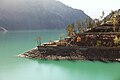 Amir Kabir Dam
 Amir Kabir Dam
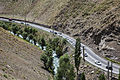 Chalus road - Ninara
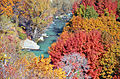 Karaj River in Adaran
 Karaj River
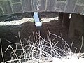 Narrow Karaj River channel under bridge


References
- Hourade, Bernard (December 15, 2010). "Karaj River". iranicaonline.org. Encyclopaedia Iranica Foundation. Retrieved 2022-02-04.
| Lake Urmia basin | |
|---|---|
| Persian Gulf basin | |
| Oman sea basin | |
| Caspian basin |
|
| Gavkhouni basin | |
| Namak Lake basin |
|
| Hamun-e Jaz Murian basin | |
| Other | |
На других языках
[de] Karadsch (Fluss)
Der Karadsch (persisch رود کرج, DMG Rūd-e Karaǧ) ist ein 245 km langer Fluss im Nordiran. Nach dem Zayandeh Rud ist der Karadsch der wichtigste Fluss des zentralen iranischen Hochlandes. Er entspringt im Elburs-Gebirge am Kaspischen Meer, fließt nach Süden durch die gleichnamige Stadt Karadsch durch und mündet später im salzigen Namaksee. Am Fluss befindet sich die Amir-Kabir-Talsperre, die die Landeshauptstadt Teheran mit Strom und Wasser versorgt.- [en] Karaj River
Текст в блоке "Читать" взят с сайта "Википедия" и доступен по лицензии Creative Commons Attribution-ShareAlike; в отдельных случаях могут действовать дополнительные условия.
Другой контент может иметь иную лицензию. Перед использованием материалов сайта WikiSort.org внимательно изучите правила лицензирования конкретных элементов наполнения сайта.
Другой контент может иметь иную лицензию. Перед использованием материалов сайта WikiSort.org внимательно изучите правила лицензирования конкретных элементов наполнения сайта.
2019-2026
WikiSort.org - проект по пересортировке и дополнению контента Википедии
WikiSort.org - проект по пересортировке и дополнению контента Википедии