geo.wikisort.org - River
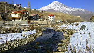
The Haraz River (Persian: رودخانه هراز) is a notable river flowing through the Mazandaran Province of northern Iran. It flows northwards, from the Alborz mountain range into the Caspian Sea. Haraz river after flowing along the Haraz Road and Valley for about 100 km it meanders in the midst of Amol, from where it reaches the Caspian Sea. Haraz River begins from Mount Damavand and flows northward and pours into Caspian Sea in the area between the two northern cities of Mahmoudabad and Fereydunkenar.[1] The Haraz River is currently contaminated due to discharges of effluent from various industrial plants.[2]
| Haraz | |
|---|---|
 Haraz River in Amol County in Spring | |
| Location | |
| Country | Iran |
| Physical characteristics | |
| Source | |
| • location | Central Alborz |
| • elevation | ≈ 3,500 m (11,500 ft) |
| Mouth | |
• location | Caspian Sea |
• elevation | ≈ −25 m (−82 ft) |
| Length | ≈ 150 km (93 mi) |
Geography
Course
The Haraz River originates at the foot of Mount Damavand in Larijan District, the highest peak of the Alborz Range. From its mountain source, it flows down into the Haraz River Valley, into the city of Amol, and onto its River mouth in the southern Caspian Sea between the towns of Fereydoon Kenar in Fereydunkenar County and Mahmoudabad in Mahmudabad County.
Haraz River Valley
Road 77 (Haraz Road) follows the river over the Hashem Pass and through the valley, and is the most important road from Tehran to the Caspian coast. It also provides access to Lar National Park, and is the nearest road to Mount Damavand, which at 5,610 metres (18,410 ft) is the highest peak in Iran and the Middle East region.


Central Alborz mountain range map
| Map of central Alborz | Peaks: | 1 Alam-Kuh |
|---|---|---|
 −25 to 500 m (−82 to 1,640 ft) 500 to 1,500 m (1,600 to 4,900 ft) 1,500 to 2,500 m (4,900 to 8,200 ft) 2,500 to 3,500 m (8,200 to 11,500 ft) 3,500 to 4,500 m (11,500 to 14,800 ft) 4,500 to 5,610 m (14,760 to 18,410 ft) |
2 Azad Kuh | 3 Damavand |
| 4 Do Berar | 5 Do Khaharan | |
| 6 Ghal'eh Gardan | 7 Gorg | |
| 8 Kholeno | 9 Mehr Chal | |
| 10 Mishineh Marg | 11 Naz | |
| 12 Shah Alborz | 13 Sialan | |
| 14 Tochal | 15 Varavašt | |
| Rivers: | 0 | |
| 1 Alamut | 2 Chalus | |
| 3 Do Hezar | 4 Haraz | |
| 5 Jajrood | 6 Karaj | |
| 7 Kojoor | 8 Lar | |
| 9 Noor | 10 Sardab | |
| 11 Seh Hazar | 12 Shahrood | |
| Cities: | 1 Amol | |
| 2 Chalus | 3 Karaj | |
| Other: | D Dizin | |
| E Emamzadeh Hashem | K Kandovan Tunnel | |
| * Latyan Dam | ** Lar Dam |
See also
- Alborz (Elburz) mountain range topics
- Tributaries of the Caspian Sea
- Tributaries of the Haraz River
References
- "Haraz River Flooding Unprecedented". Financial Tribune. 2015-04-16. Retrieved 2020-03-08.
- "Haraz River".
External links
 Media related to Haraz River at Wikimedia Commons
На других языках
- [en] Haraz River
[ru] Хераз
Хераз[1] (в верховье Руде-Лар[2]; перс. رودخانه هراز; устар. передача Рудханейе-Хераз[3]) — река в Иране, протекает по провинции Мазендеран. Впадает в Каспийское море. Общий перепад высоты более 2884[4][5] метров.Другой контент может иметь иную лицензию. Перед использованием материалов сайта WikiSort.org внимательно изучите правила лицензирования конкретных элементов наполнения сайта.
WikiSort.org - проект по пересортировке и дополнению контента Википедии