geo.wikisort.org - River
The Sefid-Rud (Persian: سفیدرود, lit. 'white river', Gilaki: اسپي بيه, Espī bīeh) (also known as Sepid-Rud) is a river approximately 670 kilometres (416 mi) long, rising in the Alborz mountain range of northwestern Iran and flowing generally northeast to enter the Caspian Sea at Rasht. The river is Iran's second longest river after the Karun.
| Sefid-Rud Sepid-Rud, Ghezel Owzan, Qizil Owzan, Qizil Ozen | |
|---|---|
 | |
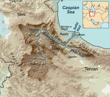 Sefīd-Rūd drainage basin | |
| Native name | Espī bīeh (Gilaki) |
| Location | |
| Country | Iran |
| Provinces | Gilan |
| City | Rasht |
| Physical characteristics | |
| Source | |
| • location | Alborz Mountains |
| Mouth | Caspian Sea |
| Length | 670 km (420 mi) |
| Basin size | 13,450 km2 (5,190 sq mi) |
| Basin features | |
| Tributaries | |
| • left | Qizil Owzan |
| • right | Shahrood |
Names
Other names and transcriptions include Sepīd-Rūd, Sefidrud, Sefidrood, Sepidrood, and Sepidrud. Above Manjil, "Long Red River".[1][2]
The river is identified with the Amardus (Ancient Greek: Ἀμάρδος) or Mardus (Μάρδος) river of antiquity.[3][4]
The river is historically famous for the quantity of its fish, especially the Caspian trout, Salmo trutta caspius.[5]
Geography
The Sefid-Rud has cut a water gap through the Alborz mountain range, the Manjil gap,[6] capturing its two headwater tributaries, the Qizil Üzan and Shahrood rivers. It then widens the valley between the Talesh Hills and the main Alborz range. The gap provides a major route between Tehran and Gīlān Province with its Caspian lowlands.[6]
In the wide valley before the Sefid-Rud enters the Caspian Sea a number of transportation and irrigation canals have been cut; the two biggest are the Khomam and the Now.[7]
Dam and reservoir
The Sefid-Rud was dammed in 1962 by the Shahbanu Farah Dam (later renamed Manjil Dam),[8] which created a 1.86 cubic kilometres (0.45 cu mi) reservoir and allowed the irrigation of an additional 2,380 km2 (919 sq mi).[8] The reservoir mediates some flooding and significantly increased rice production in the Sefid Rud Delta.[9][10] The hydroelectric component of the dam generates 87,000 kilowatts.[8] The completion of the dam had a negative impact on the river's fisheries, through reduced stream flow (due to diversion), increased water temperature, and decreased food availability, especially for sturgeon but also for the Caspian trout.[11]
History
The river was known in antiquity by the names Mardos (Greek: Μαρδος; Latin: Mardus) and Amardos (Greek: Αμαρδος; Latin: Amardus).[2] In the Hellenistic period the north side of the Sefid (then Mardus) was occupied by the mountain tribe the Cadusii.[12]
David Rohl identifies the Sefid-Rud with the Biblical Pishon river.
Gallery


Notes
- Fortescue, L. S. (April 1924) "The Western Elburz and Persian Azerbaijan" The Geographical Journal 63(4): pp. 301-315, p.310
- Rawlinson, H. C. (1840) "Notes on a Journey from Tabríz, Through Persian Kurdistán, to the Ruins of Takhti-Soleïmán, and from Thence by Zenján and Ṭárom, to Gílán, in October and November, 1838; With a Memoir on the Site of the Atropatenian Ecbatana" Journal of the Royal Geographical Society of London 10: pp. 1-64, p. 64
-
 Smith, William, ed. (1854–1857). Dictionary of Greek and Roman Geography. London: John Murray.
 {{cite encyclopedia}}: Missing or empty|title=(help) - Charles Rollin (1860). The Ancient History of the Egyptians, Assyrians, Chaldeans, Medes, Persians, Macedonians, the Selucidae in Syria, and Parthians., Volumes 3-4. Cincinnati: J.W. Sewell & Co. p. 30. Retrieved August 23, 2018.
- "Salmo trutta caspius, Kessler, 1870" Caspian Environment Programme
- Fortescue, L. S. (April 1924) "The Western Elburz and Persian Azerbaijan" The Geographical Journal 63(4): pp. 301-315, p.303
- Rabino, H. L. (November 1913) "A Journey in Mazanderan (From Resht to Sari)" The Geographical Journal 42(5): pp. 435-454, p. 435
- Beaumont, Peter (1974) "Water Resource Development in Iran" The Geographical Journal 140(3): pp. 418-431, p.428
- Gittinger, J. Price (October 1967) "Planning and Agricultural Policy in Iran: Program Effects and Indirect Effects" Economic Development and Cultural Change 16(1): pp. 107-117, p. 110
- Carey, Jane Perry Clark and Carey, Andrew Galbraith (1976) "Iranian Agriculture and Its Development: 1952-1973" International Journal of Middle East Studies 7(3): pp. 359-382, p. 372
- Jackson, Donald C. and Marmulla, Gerd (2001) "The Influence of Dams on River Fisheries: Regional Assessments: 3.2.2 Southern and Central Asia, Kazakhstan, and the Middle East" (accessed 28 November 2008), In Marmulla, Gerd (ed.) (2001) Dams, fish and fisheries: Opportunities, challenges and conflict resolution (FAO Fisheries Technical Paper. No. 419) Fisheries and Aquaculture Department, Food and Agriculture Organization, Rome, ISBN 92-5-104694-8, citing Vladykov, Vadim D. (1964) Report to the Government of Iran on the Inland Fisheries Resources of Iran, Especially of the Caspian Sea with Special Reference to Sturgeon (Expanded program of technical assistance, Report No. 1818) Food and Agriculture Organization, Rome, OCLC 236127104
- Strabo, xi. 13
External links
- "Sefid Rood Watershed" Economic potentials of Kurdistan Province in the fields of Water, Agriculture and Natural Resources Ministry of Interior, Islamic Republic of Iran
| Lake Urmia basin | |
|---|---|
| Persian Gulf basin | |
| Oman sea basin | |
| Caspian basin |
|
| Gavkhouni basin | |
| Namak Lake basin |
|
| Hamun-e Jaz Murian basin | |
| Other | |
На других языках
[de] Sefid Rud
Der Sefid Rud (persisch سفیدرود) oder auch Rud-e Safid (Weißer Fluss) ist ein 670 km langer Fluss im Nordwesten des Iran. Der Sefid Rud entspringt am Kuh-e Tschehel Tscheschmeh (کوه چهل چشمه; Vierzig-Quellen-Berg) im Zāgros-Gebirge in der Provinz Kurdistan und mündet bei Hassan Kiadeh (حسن کیاده) nordöstlich der Stadt Rascht in der Provinz Gilan ins Kaspische Meer. Er ist nach dem Karun der zweitgrößte Fluss des Irans.- [en] Sefid-Rud
[es] Río Sefid
El río Sefid, también llamado Sefid-Rud (sĕpēd rud), a veces Sepid Rud (sĕfēd´ rud) o Rud-e Safid (en persa, سفیدرود, literalmente «río Blanco»), es un río, de aproximadamente 670 km de largo, que nace en el noroeste de Irán y fluye en líneas generales hacia el este para desembocar en el mar Caspio en Rasht. El río es el segundo más largo de Irán, después del río Karún.[it] Sefid-Rud
Sefid-Rud (farsi: سفیدرود, Sefīd-Rūd), il cui nome significa "fiume bianco", con i suoi 670 km è il secondo fiume dell'Iran in ordine di lunghezza dopo il Karun. Nasce nel nord-est del paese, dai monti Elburz e sfocia nel mar Caspio all'altezza della città portuale di Bandar-e-Anzali.[ru] Сефид-Руд
Сефид-Руд[1], также Сефидру́д[2] (перс. سفیدرود — «Белая река»; в древности Мардус, Амардус) — крупная река в Северном Иране. Ранее образовывалась при слиянии горных рек Кызылузен и Шахруд у южного склона горной системы Эльбурс, ныне вытекает из водохранилища Шабанау. Воды реки затем прорывают западную оконечность хребта и впадают в Каспийское море близ Кияшахра, образуя обширную дельту.Другой контент может иметь иную лицензию. Перед использованием материалов сайта WikiSort.org внимательно изучите правила лицензирования конкретных элементов наполнения сайта.
WikiSort.org - проект по пересортировке и дополнению контента Википедии