geo.wikisort.org - Mountains
Sabalan (Persian: سبلان [sæbæ'lɒːn]) is an inactive stratovolcano in Ardabil Province of northwestern Iran.
This article includes a list of general references, but it lacks sufficient corresponding inline citations. (March 2016) |
| Sabalan | |
|---|---|
 Mount Sabalan | |
| Highest point | |
| Elevation | 4,811 m (15,784 ft)[1] |
| Prominence | 3,283 m (10,771 ft)[1] Ranked 66th |
| Isolation | 346 km (215 mi) |
| Listing | Ultra |
| Coordinates | 38°16′01″N 47°50′13″E[1] |
| Geography | |
 Sabalan Location in Iran | |
| Location | Meshkinshahr, Iran. |
| Geology | |
| Age of rock | 5.6–1.4 million years |
| Mountain type | Stratovolcano |
| Last eruption | Unknown, possibly Holocene. |
| Climbing | |
| Easiest route | hiking / scrambling |
At 4,794 metres (15,728 ft) in elevation, it is the third-highest mountain in Iran. It has a permanent crater lake formed at its summit. On one of its slopes around 3,600 metres (11,800 ft) in elevation there are large rock formations of eroded volcanic outcrops that resemble animals, birds, and insects.
Mount Sabalan
Located in the extreme northwest of Iran, Sabalan is the country's third-highest peak after Damavand and Alam-Kuh. It is also slightly higher than Mont Blanc in the Alps.
The mountain offers many attractions throughout the year. On the slopes of the mountain, the mineral water from springs attracts large numbers of tourists each year, many of whom have faith in healing properties attributed to the springs. The nomadic people of the area live in small villages, with their round "Yurt" tents appealing to tourism. Sabalan has a ski resort (Alvares) and different tourist areas such as the Sarein spa. The mountain is known for its beautiful vistas, including the Shirvan gorge, where few climbers ever venture.
Geology
Sabalan is a large andesite stratovolcano in Meshgin Shahr, in Ardabil Province in Iran. It is the second-highest volcano after Mount Damavand. The volcano is quite old. Its first eruptions occurred in the Eocene and later in the Miocene. But the main volcanism happened in the Pliocene and the Pleistocene as some of its rocks have been dated to 5–1.4 million years. Some references state that volcanic activity continued into the Holocene, less than 10,000 years ago.
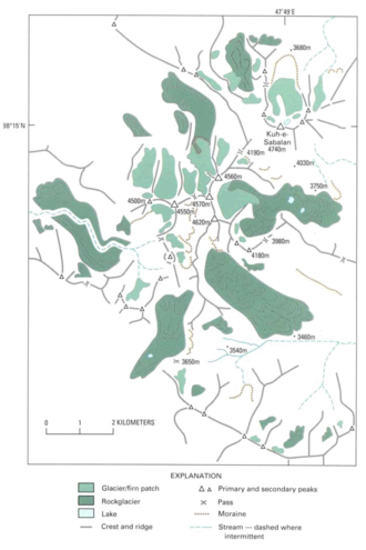
The summit region has several peaks exceeding 4,500 metres (14,800 ft), primarily along a southwest-northeast trending ridge. The highest point 4,791 metres (15,719 ft) is at the northeast end of the ridge and is separated from the 4,620 metres (15,160 ft)+ group of southwestern summits by a 4,190 m (13,750 ft) col.
The mountain is located in a continental climate with hot, dry summers and extremely cold, snowy winters. Precipitation falls primarily as snow in late autumn, winter, and spring, and is sufficient to sustain seven glaciers near the summit above 4,000 metres (13,000 ft). The largest of these were more than 1.5 kilometres (1 mi) in length as of the 1970s. There are also extensive rock glaciers, several of which are more than 3 km (2 mi) in length.
Climbing
The climbing surface includes rocks of various sizes (Class 2 scrambling), and a moderate degree of fitness is required to climb it. The climb from the base camp starts easy, becomes challenging midway, then eases in gradient near the top. The lake on the top remains frozen except for about four weeks in late July to early August.
Some climbers start by driving to hot springs of Meshgin Shahr, where they start their climb. This climb takes about two days, reaching the base camp on the first day. Others take a taxi to base camp early in the morning and climb the mountain in one day. In 2006, there was talk of improving the road to the base camp. If this is done, a regular car should be able to make it to the base camp during the climbing season. The road goes through multiple nomadic encampments of shepherds.
One or two days of acclimatization in Tehran or Ardabil may be advisable. Mountaineering has been popular among the youth in Iran. On a Friday during the climbing season (late June to mid-August), one may find hundreds of people on the mountain. Guides can also be found in Ardabil. Adequate climbing equipment can be purchased in Ardabil or Tehran.
Surrounding area
The area around Sabalan, particularly near Meshkin and Dasht-eh Moghan, produces large quantities of grain, including wheat. Due to the microclimate produced by the mountain, Ardabil remains pleasantly cool in the summers.
There are numerous hot springs around the slopes of Sabalan, with the main concentration within Sareyn County.
There are skiing slopes, with snow even in near-summer. A ski resort named "Alvares" is within an hour's drive from Sareyn on the south ridge of Sabalan.

Gallery
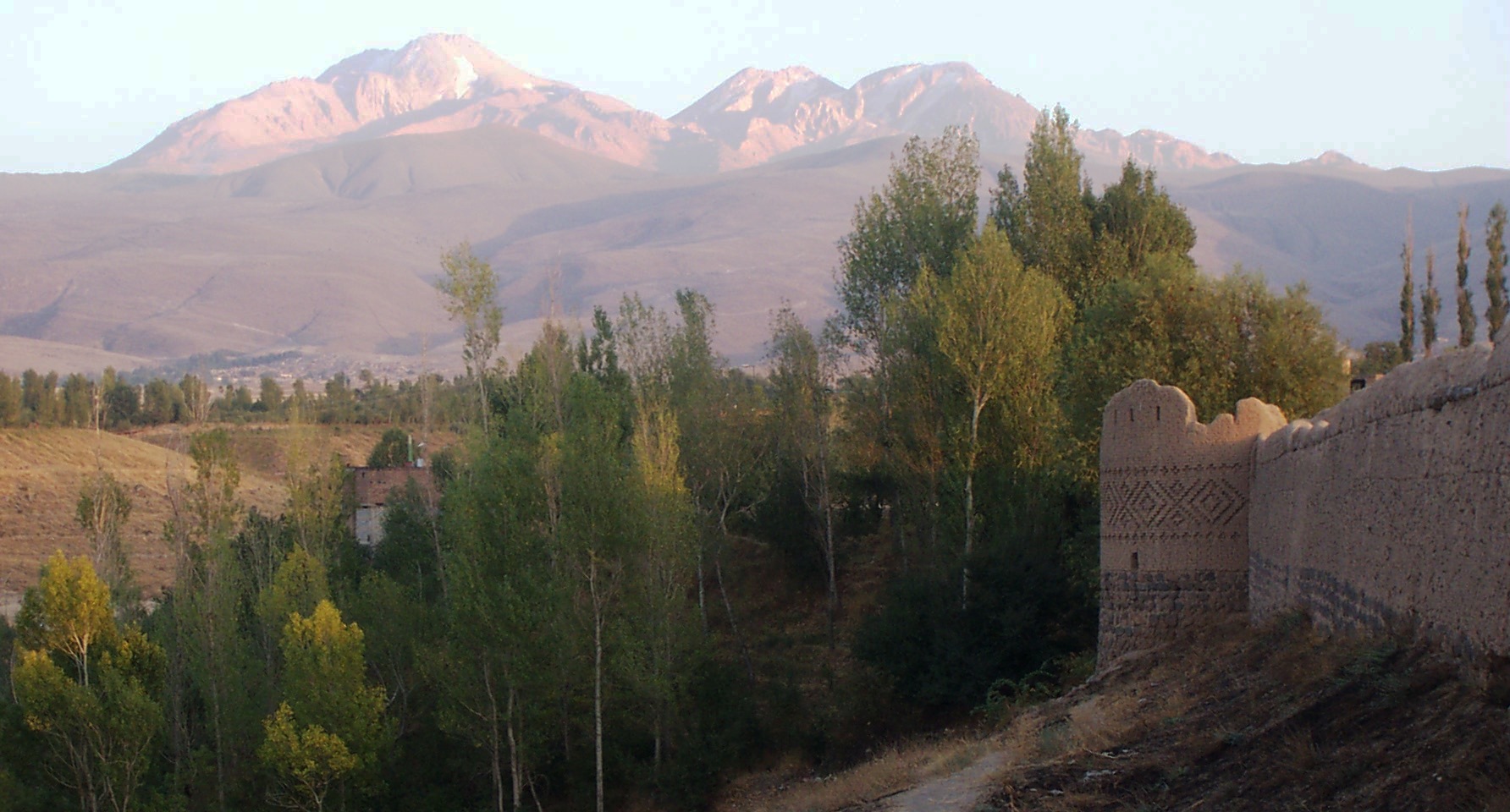
 Arshoq Castle in Meshgin Shahr in foreground, Sabalan in background
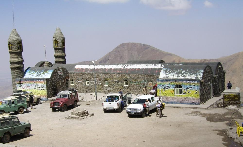
 Shelter on Sabalan at 3,600 m
 Crater lake of Sabalan
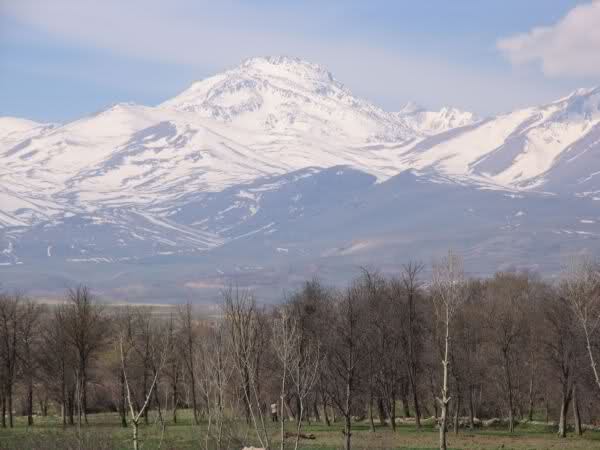
 Sabalan landscape at 4,100 m
 Igneous rock, Mr. Sabalan, Iran


See also
References
- "Iran: 54 Mountain Summits with Prominence of 1,500 meters or greater" Peaklist.org. Retrieved 2011-11-21.
- "Sabalan". Global Volcanism Program. Smithsonian Institution. Retrieved 2021-06-24.
- Williams, Richard S. Jr; Ferrigno, Jane G., eds. (1991). Satellite Image Atlas of Glaciers of the World -- Middle East and Africa. USGS Professional Paper 1386-G. pp. 37–39.
- Peaklist.org: Iran Mountain Ultra-Prominence
Sources
- Chehabi, H. E. (1997). "Ardabil Becomes a Province: Center-Periphery Relations in Iran". International Journal of Middle East Studies. 29 (2): 235–253. doi:10.1017/S0020743800064485. JSTOR 164018. S2CID 162201104. (registration required)
External links
На других языках
[de] Sabalan
Der Sabalan (persisch سبلان Sabalān) ist ein wahrscheinlich nicht mehr aktiver Schichtvulkan in der iranischen Provinz Ost-Aserbaidschan.- [en] Sabalan
[fr] Savalan
Savalan (en Azéri Sāvālān) ou Sabalan (سبلان Sabalân en Persan) est un volcan inactif dans la province d'Ardabil en Iran. Savalan est le troisième sommet d'Iran et un lac permanent s'est formé à son sommet. Savalan possède une station de ski sur ses pentes et différentes attractions touristiques comme les sources d'eau chaude de Sareyn.[it] Monte Sabalan
Il Sabalan (in persiano سبلان) è uno stratovulcano inattivo del nord dell'Iran, alto 4.811 metri[1]. È la terza cima più alta del paese e il suo cratere sommitale è permanentemente occupato da un lago. Sulle sue pendici si trova la stazione sciistica di Alvares e diverse zone turistiche, inoltre la montagna è un luogo di pellegrinaggio per gli zoroastriani.[ru] Себелан
Себела́н[2][3] (Кухе-Себелан[4][5], Савала́н[6]; перс. سبلان, произносится: Сабалан) — потухший стратовулкан на востоке Армянского нагорья[7][8], на северо-западе Исламской Республики Иран, в остане Ардебиль. Высота 4811[8] или 4821 м[4][9].Другой контент может иметь иную лицензию. Перед использованием материалов сайта WikiSort.org внимательно изучите правила лицензирования конкретных элементов наполнения сайта.
WikiSort.org - проект по пересортировке и дополнению контента Википедии