geo.wikisort.org - Mountains
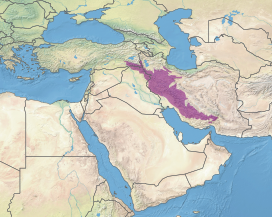
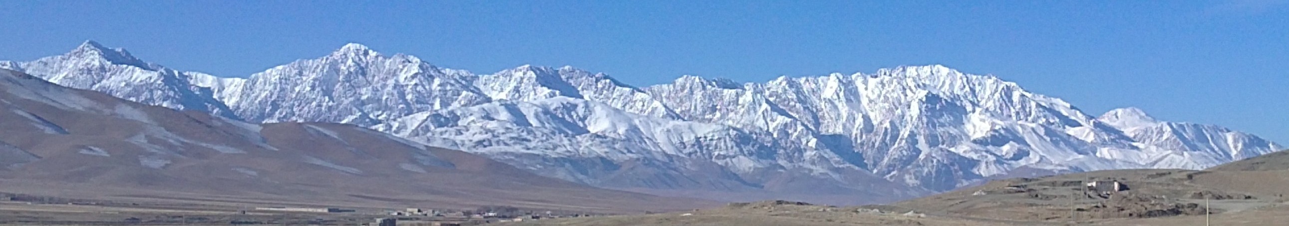
The Zagros Mountains (Arabic: جبال زاغروس, romanized: Jibal Zaghrus; Persian: کوههای زاگرس, romanized: Kuh hā-ye Zāgros; Kurdish: چیاکانی زاگرۆس, romanized: Çiyakani Zagros;[2][3] Turkish: Zagros Dağları; Luri: Kuh hā-ye Zāgros کویا زاگرس) are a long mountain range in Iran, northern Iraq, and southeastern Turkey. This mountain range has a total length of 1,600 km (990 mi). The Zagros mountain range begins in northwestern Iran and roughly follows Iran's western border while covering much of southeastern Turkey and northeastern Iraq. From this border region, the range continues to the southeast under also the waters of the Persian Gulf. It spans the southern parts of the Armenian highland, the whole length of the western and southwestern Iranian plateau, ending at the Strait of Hormuz. The highest point is Mount Dena, at 4,409 metres (14,465 ft).
| Zagros | |
|---|---|
 | |
| Highest point | |
| Peak | Qash-Mastan (Dena) |
| Elevation | 4,409 m (14,465 ft) |
| Coordinates | 30°57′N 51°26′E |
| Dimensions | |
| Length | 1,600 km (990 mi)[1] |
| Width | 240 km (150 mi)[1] |
| Geography | |
| Location | Iran, Iraq, and Turkey Middle East or Western Asia |
| Range coordinates | 33°40′N 47°00′E |
| Geology | |
| Age of rock | Carboniferous |
| Mountain type | Fold and thrust belt |
Geology

![The Zagros Mountains from space, September 1992[4]](http://upload.wikimedia.org/wikipedia/commons/0/01/Zagros_1992.jpg)
The Zagros fold and thrust belt was mainly formed by the collision of two tectonic plates, the Eurasian Plate and the Arabian Plate.[5] This collision mainly happened during the Miocene (about 25–5 million years ago or mya) and folded the entirety of the rocks that had been deposited from the Paleozoic (541–242 mya) to the Cenozoic (66 mya – present) in the passive continental margin on the Arabian Plate. However, the obduction of Neotethys oceanic crust during the Cretaceous (145–66 mya), and the continental arc collision in the Eocene (56–34 mya) both had major effects on uplifts in the northeastern parts of the belt.
The process of collision continues to the present, and as the Arabian Plate is being pushed against the Eurasian Plate, the Zagros Mountains and the Iranian plateau are getting higher and higher. Recent GPS measurements in Iran[6] have shown that this collision is still active and the resulting deformation is distributed non-uniformly in the country, mainly taken up in the major mountain belts like Alborz and Zagros. A relatively dense GPS network which covered the Iranian Zagros[7] also proves a high rate of deformation within the Zagros. The GPS results show that the current rate of shortening in the southeast Zagros is ~10 mm/a (0.39 in/year), dropping to ~5 mm/a (0.20 in/year) in the northwest Zagros. The north–south Kazerun strike-slip fault divides the Zagros into two distinct zones of deformation. The GPS results also show different shortening directions along the belt, normal shortening in the southeast, and oblique shortening in the northwest Zagros. The Zagros mountains were created around the time of the second ice age,[citation needed] which caused the tectonic collision, leading to its uniqueness.
The sedimentary cover in the SE Zagros is deforming above a layer of rock salt (acting as a ductile decollement with a low basal friction), whereas in the NW Zagros the salt layer is missing or is very thin. This different basal friction is partly responsible for the different topographies on either side of the Kazerun fault. Higher topography and narrower zone of deformation in the NW Zagros is observed whereas in the SE, deformation was spread more and a wider zone of deformation with lower topography was formed.[8] Stresses induced in the Earth's crust by the collision caused extensive folding of the preexisting layered sedimentary rocks. Subsequent erosion removed softer rocks, such as mudstone (rock formed by consolidated mud) and siltstone (a slightly coarser-grained mudstone) while leaving harder rocks, such as limestone (calcium-rich rock consisting of the remains of marine organisms) and dolomite (rocks similar to limestone containing calcium and magnesium). This differential erosion formed the linear ridges of the Zagros Mountains.
The depositional environment and tectonic history of the rocks were conducive to the formation and trapping of petroleum, and the Zagros region is an important area for oil production. Salt domes and salt glaciers are a common feature of the Zagros Mountains. Salt domes are an important target for petroleum exploration, as the impermeable salt frequently traps petroleum beneath other rock layers. There is also much water-soluble gypsum in the region.[9]
Type and age of rock
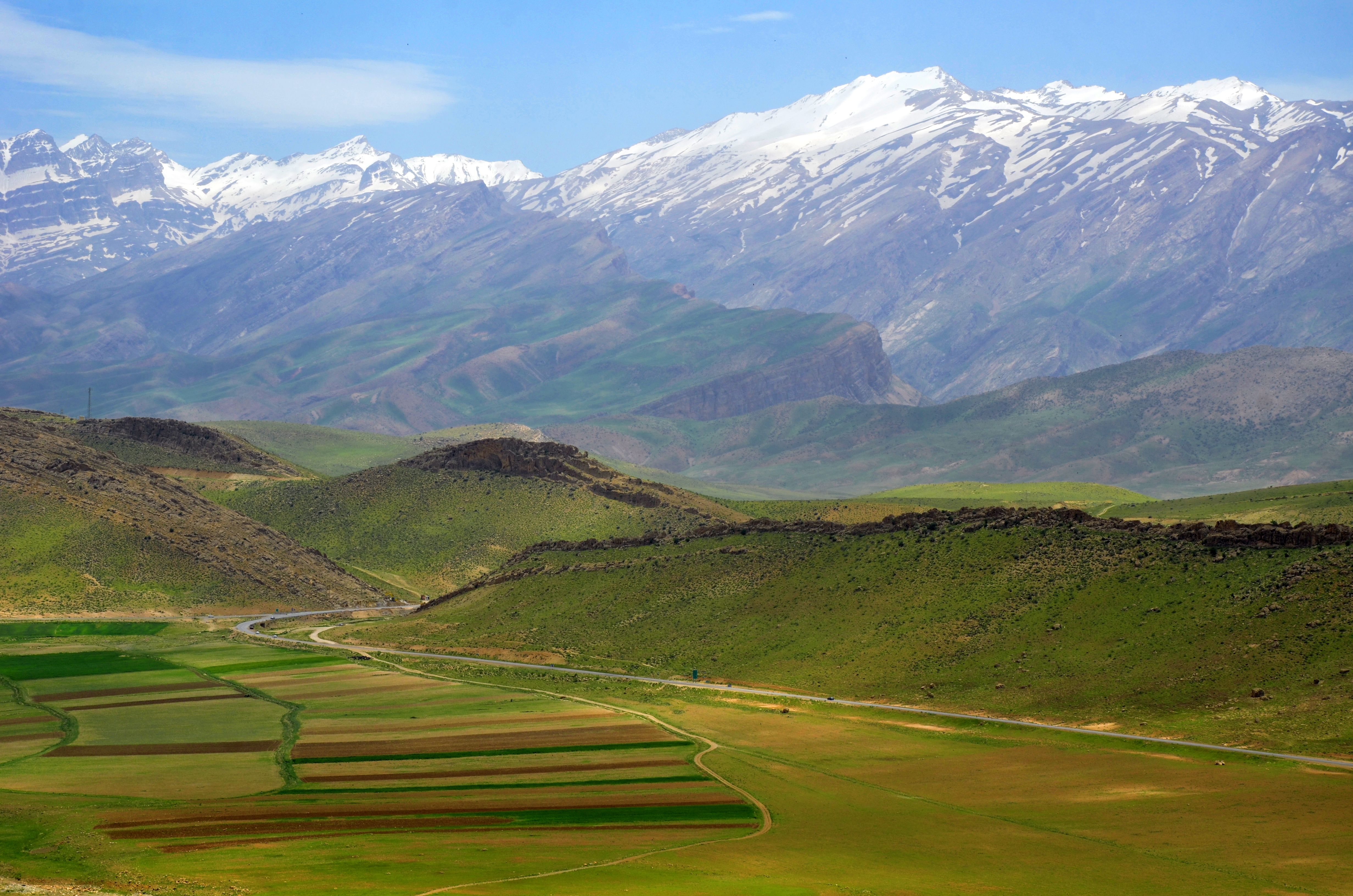
The mountains are completely of sedimentary origin and are made primarily of limestone. In the Elevated Zagros or the Higher Zagros, the Paleozoic rocks can be found mainly in the upper and higher sections of the peaks of the Zagros Mountains, along the Zagros main fault. On both sides of this fault, there are Mesozoic rocks, a combination of Triassic (252–201 mya) and Jurassic (201–145 mya) rocks that are surrounded by Cretaceous rocks on both sides. The Folded Zagros (the mountains south of the Elevated Zagros and almost parallel to the main Zagros fault) is formed mainly of Tertiary rocks, with the Paleogene (66–23 mya) rocks south of the Cretaceous rocks and then the Neogene (23–2.6 mya) rocks south of the Paleogene rocks. The mountains are divided into many parallel sub-ranges (up to 10 or 250 km (6.2 or 155.3 mi) wide), and orogenically have the same age as the Alps.
Iran's main oilfields lie in the western central foothills of the Zagros mountain range. The southern ranges of the Fars Province have somewhat lower summits, reaching 4,000 metres (13,000 feet). They contain some limestone rocks showing abundant marine fossils.[8]
History


The Zagros Mountains have significant ancient history. They were occupied by early humans since the Lower Paleolithic Period. The earliest human fossils discovered in Zagros belongs to Neanderthals and come from Shanidar Cave, Bisitun Cave, and Wezmeh Cave. The remains of ten Neanderthals, dating from around 65,000–35,000 years ago, have been found in the Shanidar Cave.[10] The cave also contains two later "proto-Neolithic" cemeteries, one of which dates back about 10,600 years and contains 35 individuals.[11] Evidence from later Upper Paleolithic and Epipaleolithic occupations come from Yafteh Cave, Kaldar Cave near Khoramabad, and Warwasi, Malaverd near Kermanshah, Kenacheh Cave in Kurdistan, Boof Cave in Fars and a number of other caves and rock shelters.[12]
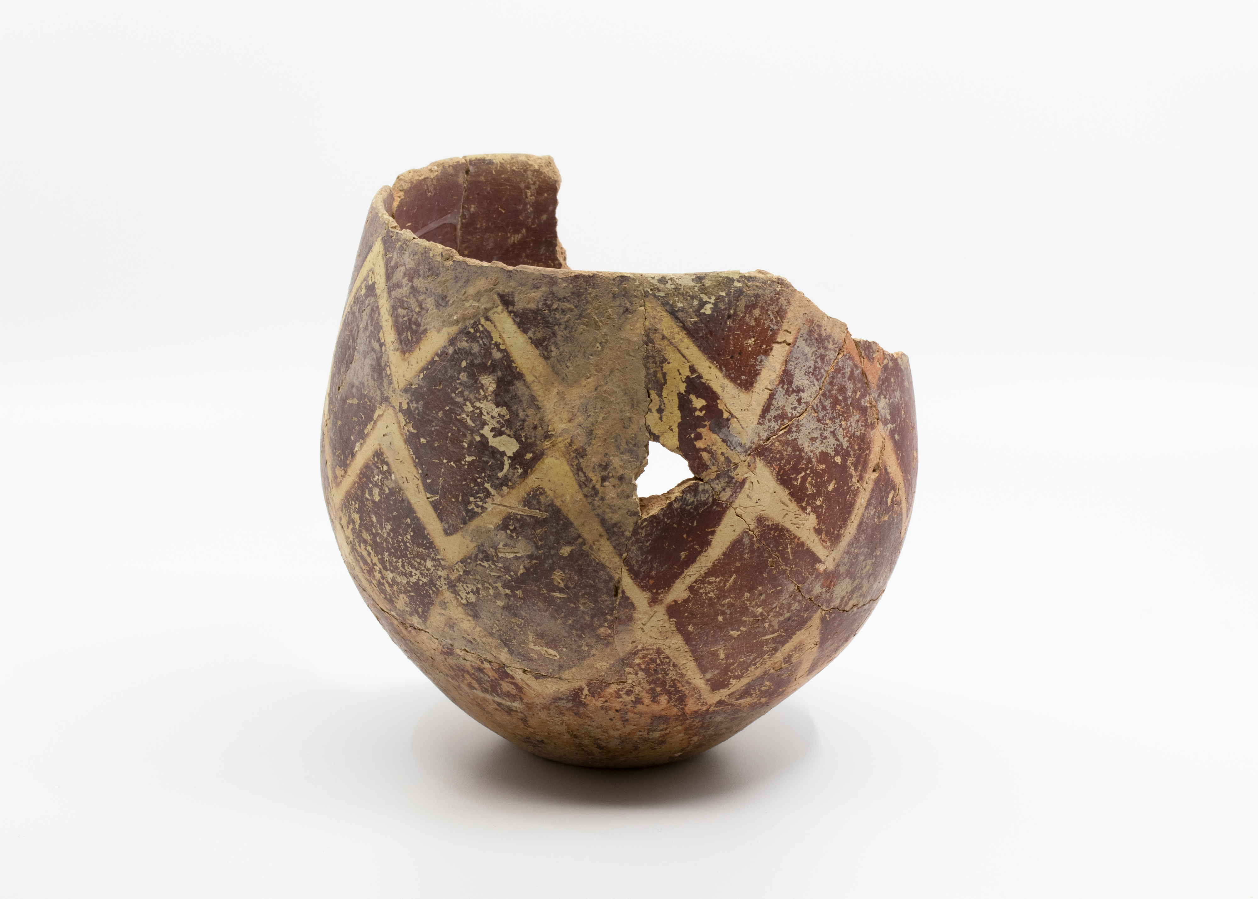
Signs of early agriculture date back as far as 9000 BC in the foothills of the mountains.[13] Some settlements later grew into cities, eventually named Anshan and Susa; Jarmo is one archaeological site in this area. Some of the earliest evidence of wine production has been discovered in the mountains; both the settlements of Hajji Firuz Tepe and Godin Tepe have given evidence of wine storage dating between 3500 and 5400 BC.[14]
During early ancient times, the Zagros was the home of peoples such as the later, the Kassites, Guti, Elamites and Mitanni, who periodically invaded the Sumerian and/or Akkadian cities of Mesopotamia. The mountains create a geographic barrier between the Mesopotamian Plain, which is in Iraq, and the Iranian plateau. A small archive of clay tablets detailing the complex interactions of these groups in the early second millennium BC has been found at Tell Shemshara along the Little Zab.[15] Tell Bazmusian, near Shemshara, was occupied between 5000 BCE and 800 CE, although not continuously.[16]
Kurds

The Zagros mountains has been inhabited by the Kurds for thousands of years and saw the development of Kurdish culture and history.[17] The high altitude of the Zagros mountains produces a series of choke points and valleys perfect for agriculture and human development.[18] It has also long defended the Kurds in times of war by acting as a natural barrier.[19]
Climate
The mountains contain several ecosystems. Prominent among them are the forest and forest steppe areas with a semi-arid climate. As defined by the World Wildlife Fund and used in their Wildfinder, the particular terrestrial ecoregion of the mid to high mountain area is Zagros Mountains forest steppe (PA0446). The annual precipitation ranges from 400–800 mm (16–31 in) and falls mostly in winter and spring. Winters are severe, with low temperatures often below −25 °C (−13 °F). The region exemplifies the continental variation of the Mediterranean climate pattern, with a snowy winter and mild, rainy spring, followed by a dry summer and autumn.[20]
| Climate data for Amadiya District, Iraq | |||||||||||||
|---|---|---|---|---|---|---|---|---|---|---|---|---|---|
| Month | Jan | Feb | Mar | Apr | May | Jun | Jul | Aug | Sep | Oct | Nov | Dec | Year |
| Average high °C (°F) | −0.2 (31.6) |
1.4 (34.5) |
6.4 (43.5) |
12.2 (54.0) |
19.3 (66.7) |
24.8 (76.6) |
29.7 (85.5) |
29.6 (85.3) |
25.6 (78.1) |
17.7 (63.9) |
9.7 (49.5) |
2.7 (36.9) |
14.9 (58.8) |
| Average low °C (°F) | −8.0 (17.6) |
−6.8 (19.8) |
−2.0 (28.4) |
3.5 (38.3) |
8.8 (47.8) |
13.0 (55.4) |
17.3 (63.1) |
16.9 (62.4) |
13.0 (55.4) |
7.2 (45.0) |
2.1 (35.8) |
−4.3 (24.3) |
5.1 (41.1) |
| Source: [21] | |||||||||||||
Glaciation
The mountains of the East-Zagros, the Kuh-i-Jupar (4,135 m (13,566 ft)), Kuh-i-Lalezar (4,374 m (14,350 ft)) and Kuh-i-Hezar (4,469 m (14,662 ft)) do not currently have glaciers. Only at Zard Kuh and Dena some glaciers still survive. However, before the Last Glacial Period they had been glaciated to a depth in excess of 1,900 metres (1.2 miles), and during the Last Glacial Period to a depth in excess of 2,160 metres (7,090 feet). Evidence exists of a 20 km (12 mi) wide glacier fed along a 17 km (11 mi) long valley dropping approximately 1,600 m (5,200 ft) along its length on the north side of Kuh-i-Jupar with a thickness of 350–550 m (1,150–1,800 ft). Under conditions of precipitation comparable to current climatic record-keeping, this size of glacier could be expected to form where the annual average temperature was between 10.5 and 11.2 °C (50.9 and 52.2 °F), but since conditions are expected to have been dryer during the period in which this glacier was formed, the temperature must have been lower.[22][23][24][25]
Flora and fauna

Although currently degraded through overgrazing and deforestation, the Zagros region is home to a rich and complex flora. Remnants of the originally widespread oak-dominated woodland can still be found, as can the park-like pistachio/almond steppelands. The ancestors of many familiar foods, including wheat, barley, lentil, almond, walnut, pistachio, apricot, plum, pomegranate and grape can be found growing wild throughout the mountains.[27] Persian oak (Quercus brantii) (covering more than 50% of the Zagros forest area) is the most important tree species of the Zagros in Iran.[28]

Other floral endemics found within the mountain range include: Allium iranicum, Astragalus crenophila, Bellevalia kurdistanica, Cousinia carduchorum, Cousinia odontolepis, Echinops rectangularis, Erysimum boissieri, Iris barnumiae, Ornithogalum iraqense, Scrophularia atroglandulosa, Scorzonera kurdistanica, Tragopogon rechingeri, and Tulipa kurdica.[29] The Zagros are home to many threatened or endangered organisms, including the Zagros Mountains mouse-like hamster (Calomyscus bailwardi), the Basra reed-warbler (Acrocephalus griseldis) and the striped hyena (Hyena hyena). Luristan newt (Neurergus kaiseri) – vulnerable endemic to the central Zagros mountains of Iran. The Persian fallow deer (Dama dama mesopotamica), an ancient domesticate once thought extinct, was rediscovered in the late 20th century in Khuzestan Province, in the southern Zagros. Also, wild goats can be found almost all over the Zagros mountain range.

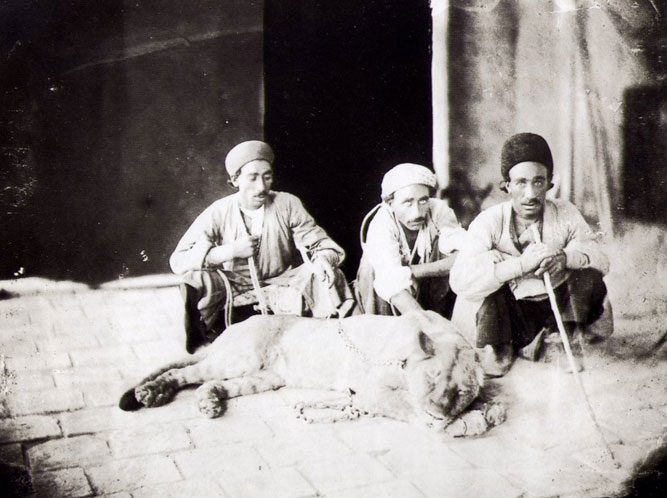
In the late 19th century, the Asiatic lion (Panthera leo persica)[30] inhabited the southwestern part of the mountains. It is now extinct in this region.[31]
Religion
The entrance to the ancient Mesopotamian underworld was believed to be located in the Zagros Mountains in the far east.[32] A staircase led down to the gates of the underworld.[32] The underworld itself is usually located even deeper below ground than the Abzu, the body of freshwater which the ancient Mesopotamians believed lay deep beneath the earth.[32]
Gallery
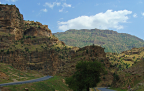 A road through the Zagros mountains in Kurdistan region, Iraq
 Wild goat herd, Zagros, Behbahan
 Fritillaria imperialis in Dena, Iranian Zagros


See also
Part of Zagros Mountains and their history
- Battle of the Persian Gate
- Mount Alvand
- Mount Arbaba
- Mount Derak
- Mount Judiof the Koran
- Qaleh gorikhteh
Other
- Alborz Mountains
- Al Hajar Mountains, technically a continuation of the Zagros in the Arabian Peninsula
- Caucasus Mountains
- Geography of Turkey
- Geography of Iraq
- Mount Elbrus
- Silakhor Plain
- Taurus Mountains
- Wildlife of Iran
- Wildlife of Iraq
- Wildlife of Turkey
References
- "Zagros Mountains". Encyclopedia Britannica. Retrieved 17 August 2017.
- "Li Îranê 66 Kes di Ketina Firokeka Bazirganî de Têne Kuştin". VOA (Dengê Amerika) (in Kurdish). 18 February 2018. Retrieved 18 December 2019.
- "چەند دیمەنێکی زنجیرە چیاکانی زاگرۆس". Basnews (in Kurdish). Retrieved 18 December 2019.
- "Salt Dome in the Zagros Mountains, Iran". NASA Earth Observatory. Archived from the original on 1 October 2006. Retrieved 27 April 2006.
- Scheffel, Richard L.; Wernet, Susan J., eds. (1980). Natural Wonders of the World. United States of America: Reader's Digest Association, Inc. pp. 422–423. ISBN 0-89577-087-3.
- Nilforoushan F., Masson F., Vernant P., Vigny C., Martinod J., Abbassi M., Nankali H., Hatzfeld D., Bayer R., Tavakoli F., Ashtiani A., Doerflinger E., Daignières M., Collard P., Chéry J. (2003). "GPS network monitors the Arabia-Eurasia collision deformation in Iran". Journal of Geodesy, 77, 411–422.
- Hessami K., Nilforoushan F., Talbot CJ., 2006, "Active deformation within the Zagros Mountains deduced from GPS measurements". Journal of the Geological Society, London, 163, 143–148.
- Nilforoushan F, Koyi HA., Swantesson J.O.H., Talbot CJ., 2008, "Effect of basal friction on the surface and volumetric strain in models of convergent settings measured by laser scanner", Journal of Structural Geology, 30, 366–379.
- "Multimedia Gallery – Gypsum from land to sea: Iran's Zagros Mountains contain much water-soluble gypsum". NSF – National Science Foundation.
- Murray, Tim (2007). Milestones in Archaeology: A Chronological Encyclopedia. ABC-CLIO. p. 454. ISBN 9781576071861.
- Ralph S. Solecki; Rose L. Solecki & Anagnostis P. Agelarakis (2004). The Proto-Neolithic Cemetery in Shanidar Cave. Texas A&M University Press. pp. 3–5. ISBN 9781585442720.
- Shidrang S, (2018) The Middle to Upper Paleolithic Transition in the Zagros: The Appearance and Evolution of the Baradostian, In The Middle and Upper Paleolithic Archeology of the Levant and Beyond, Y. Nishiaki, T. Akazawa (eds.), pp. 133–156, Replacement of Neanderthals by Modern Humans Series, Tokyo.
- La Mediterranée, Braudel, Fernand, 1985, Flammarion, Paris
- Phillips, Rod. A Short History of Wine. New York: Harper Collins. 2000.
- Eidem, Jesper; Læssøe, Jørgen (2001), The Shemshara archives 1. The letters, Historisk-Filosofiske Skrifter, vol. 23, Copenhagen: Kongelige Danske videnskabernes selskab, ISBN 87-7876-245-6
- Al-Soof, Behnam Abu (1970). "Mounds in the Rania Plain and excavations at Tell Bazmusian (1956)". Sumer. 26: 65–104. ISSN 0081-9271.
- Forti, Luca; Perego, Alessandro; Brandolini, Filippo; Mariani, Guido S.; Zebari, Mjahid; Nicoll, Kathleen; Regattieri, Eleonora; Barbaro, Cecilia Conati; Bonacossi, Daniele Morandi; Qasim, Hasan Ahmed; Cremaschi, Mauro; Zerboni, Andrea (1 December 2021). "Geomorphology of the northwestern Kurdistan Region of Iraq: landscapes of the Zagros Mountains drained by the Tigris and Great Zab Rivers". Journal of Maps. 17 (2): 225–236. doi:10.1080/17445647.2021.1906339. S2CID 234879238 – via Taylor and Francis+NEJM.
- Wright, H. E. (1980). "Climatic Change and Plant Domestication in the Zagros Mountains". Iran. 18: 145–148. doi:10.2307/4299696. JSTOR 4299696 – via JSTOR.
- Settlement continuity in Kurdistan Yaghoub Mohammadifar & Abbass Motarjem, Antiquity Vol 82 Issue 317 September 2008
- Frey, W.; W. Probst (1986). Kurschner, Harald (ed.). "A synopsis of the vegetation in Iran". Contributions to the Vegetation of Southwest Asia. Wiesbaden, Germany: L. Reichert: 9–43. ISBN 3-88226-297-4.
- "Climate statistics for Amadiya". Meteovista. Retrieved 6 September 2014.
- Kuhle, M. (1974):Vorläufige Ausführungen morphologischer Feldarbeitsergebnisse aus den SE-Iranischen Hochgebirgen am Beispiel des Kuh-i-Jupar. Zeitschrift für Geomorphologie N.F., 18, (4), pp. 472–483.
- Kuhle, M. (1976):Beiträge zur Quartärgeomorphologie SE-Iranischer Hochgebirge. Die quartäre Vergletscherung des Kuh-i-Jupar. Göttinger Geographische Abhandlungen, 67, Vol. I, pp. 1–209; Vol. II, pp. 1–105.
- Kuhle, M. (2007):The Pleistocene Glaciation (LGP and pre-LGP, pre-LGM) of SE-Iranian Mountains exemplified by the Kuh-i-Jupar, Kuh-i-Lalezar and Kuh-i-Hezar Massifs in the Zagros. Polarforschung, 77, (2–3), pp. 71–88. (Erratum/ Clarification concerning Figure 15, Vol. 78, (1–2), 2008, p. 83.
- Elsevier: Ehlers. "Quaternary Glaciations – Extent and Chronology Volume 15: A closer look Welcome". booksite.elsevier.com.
- Sevruguin, A. (1880). "Men with live lion". National Museum of Ethnology in Leiden, The Netherlands; Stephen Arpee Collection. Retrieved 26 March 2018.
- Miller, Naomi F. (2006). "The Origins of Plant Cultivation in the Near East". In Cowan, C. Wesley; Watson, Patty Jo; Benco, Nancy L. (eds.). The origins of Agriculture: An International Perspective ([New ed.]. ed.). Tuscaloosa, Ala.: University of Alabama Press. p. 41. ISBN 0-8173-5349-6. Retrieved 5 May 2012.
- M. Heydari; H. Poorbabaei; T. Rostami; M. Begim Faghir; A. Salehi; R. Ostad Hashmei (2013). "Plant species in Oak (Quercus brantii Lindl.) understory and their relationship with physical and chemical propertiesof soil in different altitude classes in the Arghvan valley protected area, Iran" (PDF). Caspian Journal of Environmental Sciences, 2013, Vol. 11 No.1, pp. 97~110. Archived from the original (PDF) on 3 April 2015. Retrieved 10 April 2014.
- "Haji Omran Mountain (IQ018)" (PDF). natrueiraq.org. Retrieved 22 June 2016.
- Kitchener, A. C.; Breitenmoser-Würsten, C.; Eizirik, E.; Gentry, A.; Werdelin, L.; Wilting A.; Yamaguchi, N.; Abramov, A. V.; Christiansen, P.; Driscoll, C.; Duckworth, J. W.; Johnson, W.; Luo, S.-J.; Meijaard, E.; O’Donoghue, P.; Sanderson, J.; Seymour, K.; Bruford, M.; Groves, C.; Hoffmann, M.; Nowell, K.; Timmons, Z.; Tobe, S. (2017). "A revised taxonomy of the Felidae: The final report of the Cat Classification Task Force of the IUCN Cat Specialist Group" (PDF). Cat News. Special Issue 11.
- Heptner, V. G.; Sludskij, A. A. (1992) [1972]. "Lion". Mlekopitajuščie Sovetskogo Soiuza. Moskva: Vysšaia Škola [Mammals of the Soviet Union. Volume II, Part 2. Carnivora (Hyaenas and Cats)]. Washington DC: Smithsonian Institution and the National Science Foundation. pp. 82–95. ISBN 90-04-08876-8.
- Black, Jeremy; Green, Anthony (1992), Gods, Demons and Symbols of Ancient Mesopotamia: An Illustrated Dictionary, Austin, Texas: University of Texas Press, p. 180, ISBN 0714117056
External links
- Zagros, Photos from Iran, Livius.
- The genus Dionysia Archived 4 December 2019 at the Wayback Machine
- Iran, Timeline of Art History
- Mesopotamia 9000–500 B.C.
- Major Peaks of the Zagros Mountains
Ancient Mesopotamia | ||||||
|---|---|---|---|---|---|---|
| Geography |
|  | ||||
| History |
| |||||
| Languages | ||||||
| Culture / Society |
| |||||
| Archaeology |
| |||||
| Religion |
| |||||
| Academia |
| |||||
Iran topics | |||||||||||||||||||||||||||||||
|---|---|---|---|---|---|---|---|---|---|---|---|---|---|---|---|---|---|---|---|---|---|---|---|---|---|---|---|---|---|---|---|
| |||||||||||||||||||||||||||||||
| |||||||||||||||||||||||||||||||
| |||||||||||||||||||||||||||||||
| |||||||||||||||||||||||||||||||
| |||||||||||||||||||||||||||||||
| |||||||||||||||||||||||||||||||
| |||||||||||
| |||||||||||
| |||||||||||
| |||||||||||
| |||||||||||
| |||||||||||
Authority control | |
|---|---|
| General |
|
| National libraries | |
На других языках
- [en] Zagros Mountains
[es] Zagros
Zagros (en persa: رشته كوه زاگرس, Reshiteh-e Kuh-e Zagres, en kurdo: Çîyayên Zagrosê) constituye la cadena montañosa más larga de Irak y de Irán. Se extiende a lo largo de 1500 kilómetros desde el Kurdistán iraquí en el noroeste de Irán hasta el estrecho de Ormuz en el golfo Pérsico. Es paralela a la frontera occidental de Irán y se prolonga por todo lo largo del oeste y suroeste de la meseta iraní. El macizo de Hazaran en la provincia de Kerman iraní es la parte más oriental de la cordillera, la cadena Jebal Barez se extiende hasta Sistán. Los puntos más altos de los montes Zagros son Zard Kuh-bajtiarí y Dena.[fr] Monts Zagros
Les monts Zagros (en persan رشته كوه زاگرس, Reschte-Kuh-e Zāgros, en kurde Çîyayên Zagrosê, en lori, كۆیەل زاگرۥۇس, en turc Zagros Dağları) sont une chaîne de montagnes s'étendant principalement dans l'Ouest de l'Iran, depuis le détroit d'Ormuz dans le golfe Persique jusqu'au haut-plateau arménien dans le Sud-Est de la Turquie en passant par le Nord-Est de l'Irak. Elle a une longueur totale de 1 600 kilomètres. Son point culminant se trouve dans le massif de Dena avec 4 409 mètres d'altitude.[it] Monti Zagros
I Monti Zagros (persiano: رشته كوه زاگرس Rashte Kuh Zāgros; curdo: Çiyayên Zagrosê[1], Ciyayén Zagrosé[2] o semplicemente Zagros) sono la catena montuosa più estesa in Iraq e Iran. Essi hanno una lunghezza totale di 1500 km dall'Iran occidentale, specificamente dalla regione del Kurdistan ai confini dell'Iraq, fino al Golfo Persico. La catena finisce sullo Stretto di Hormuz. Il punto più alto dei Monti Zagros è il monte Dena con 4.409 metri. Altra montagna importante è lo Zard Kuh. Formate dalla collisione della placca euroasiatica con la placca arabica, la catena si estende per centinaia di chilometri. I curdi ritengono di essere nati su queste montagne. Nell'antichità esisteva un passo chiamato porta persiana.[ru] Загрос
Загро́с (курдск. چیاکانی زاگرۆس, Çiyayên Zagrosê; перс. زاگرس; тур. Zagros Dağları) — крупнейшая горная система современного Ирана. Некоторые отроги Загроса простираются также на территорию Ирака и юго-восточной Турции.Другой контент может иметь иную лицензию. Перед использованием материалов сайта WikiSort.org внимательно изучите правила лицензирования конкретных элементов наполнения сайта.
WikiSort.org - проект по пересортировке и дополнению контента Википедии