geo.wikisort.org - River
The Tigris (/ˈtaɪɡrɪs/) is the easternmost of the two great rivers that define Mesopotamia, the other being the Euphrates. The river flows south from the mountains of the Armenian Highlands through the Syrian and Arabian Deserts, and empties into the Persian Gulf.
| Tigris | |
|---|---|
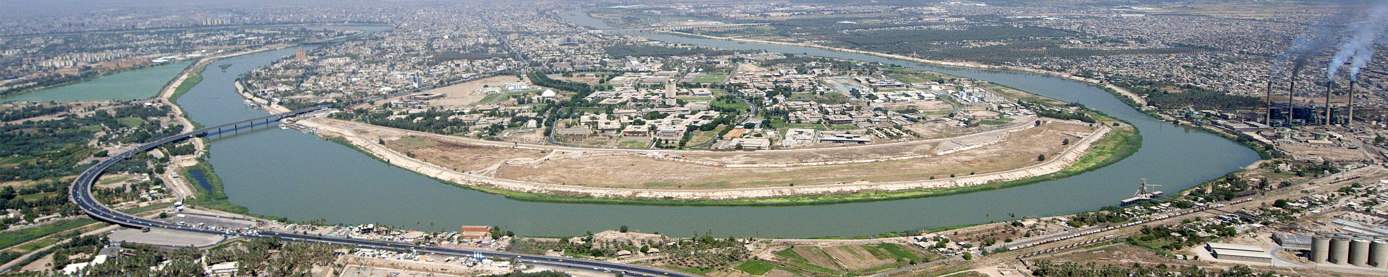 Tigris river in Baghdad | |
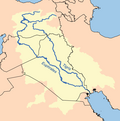
 Map of the Tigris–Euphrates river system | |
| Location | |
| Country | Turkey, Syria, Iraq |
| Source region | Armenian Highlands |
| Cities | Elazığ, Diyarbakır, Mosul, Baghdad |
| Physical characteristics | |
| Source | Lake Hazar[1] |
| • coordinates | 38°29′0″N 39°25′0″E |
| • elevation | 1,150 m (3,770 ft) |
| Mouth | Shatt al-Arab |
• location | Al-Qurnah, Basra Governorate, Iraq |
• coordinates | 38°26′0″N 39°46′22″E |
| Length | 1,900 km (1,200 mi) |
| Basin size | 375,000 km2 (145,000 sq mi) |
| Discharge | |
| • location | Baghdad |
| • average | 1,014 m3/s (35,800 cu ft/s) |
| • minimum | 337 m3/s (11,900 cu ft/s) |
| • maximum | 2,779 m3/s (98,100 cu ft/s) |
| Basin features | |
| River system | Tigris–Euphrates river system |
| Tributaries | |
| • left | Garzan, Botan, Khabur, Greater Zab, Lesser Zab, 'Adhaim, Cizre, Diyala |
| • right | Wadi Tharthar |
| [2][3] | |

Geography
The Tigris is 1,750 km (1,090 mi) long, rising in the Taurus Mountains of eastern Turkey about 25 km (16 mi) southeast of the city of Elazığ and about 30 km (20 mi) from the headwaters of the Euphrates. The river then flows for 400 km (250 mi) through Southeastern Turkey before becoming part of the Syria-Turkey border. This stretch of 44 km (27 mi) is the only part of the river that is located in Syria.[2] Some of its affluences are Garzan, Anbarçayi, Batman, and the Great and the Little Zab.[4]
Close to its confluence with the Euphrates, the Tigris splits into several channels. First, the artificial Shatt al-Hayy branches off, to join the Euphrates near Nasiriyah. Second, the Shatt al-Muminah and Majar al-Kabir branch off to feed the Central Marshes. Further downstream, two other distributary channels branch off (the Al-Musharrah and Al-Kahla), to feed the Hawizeh Marshes. The main channel continues southwards and is joined by the Al-Kassarah, which drains the Hawizeh Marshes. Finally, the Tigris joins the Euphrates near al-Qurnah to form the Shatt-al-Arab. According to Pliny and other ancient historians, the Euphrates originally had its outlet into the sea separate from that of the Tigris.[5]
Baghdad, the capital of Iraq, stands on the banks of the Tigris. The port city of Basra straddles the Shatt al-Arab. In ancient times, many of the great cities of Mesopotamia stood on or near the Tigris, drawing water from it to irrigate the civilization of the Sumerians. Notable Tigris-side cities included Nineveh, Ctesiphon, and Seleucia, while the city of Lagash was irrigated by the Tigris via a canal dug around 2900 B.C.
Navigation
The Tigris has long been an important transport route in a largely desert country. Shallow-draft vessels can go as far as Baghdad, but rafts are needed for transport upstream to Mosul.[6][7][8]
Etymology

The Ancient Greek form Tigris (Τίγρις) is an alternative form of Tígrēs (Τίγρης), which was adapted from Old Persian 𐎫𐎡𐎥𐎼𐎠 (t-i-g-r-a /Tigrā/), itself from Elamite Tigra, itself from Sumerian 𒀀𒇉𒈦𒄘𒃼 (Idigna or Idigina, probably derived from *id (i)gina "running water").[9] The Sumerian term, which can be interpreted as "the swift river", contrasts the Tigris to its neighbour, the Euphrates, whose leisurely pace caused it to deposit more silt and build up a higher bed than the Tigris. The Sumerian form was borrowed into Akkadian as Idiqlat and from there into the other Semitic languages (compare Hebrew Ḥîddeqel, Syriac Deqlaṯ, Arabic Dijlah).[citation needed]
Another name for the Tigris used in Middle Persian was Arvand Rud, literally "swift river". Today, however, Arvand Rud (New Persian: اروند رود) refers to the confluence of the Euphrates and Tigris rivers, known in Arabic as the Shatt al-Arab. In Kurdish, it is known as Ava Mezin, "the Great Water".[citation needed]


The name of the Tigris in languages that have been important in the region:
| Language | Name for Tigris |
|---|---|
| Akkadian | 𒁇𒄘𒃼, Idiqlat |
| Arabic | دجلة, Dijlah; حداقل, Ḥudaqil |
| Aramaic | דיגלת, Diglath |
| Armenian | Տիգրիս, Tigris, Դգլաթ, Dglatʿ |
| Greek | ἡ Τίγρης, -ητος, hē Tígrēs, -ētos;
ἡ, ὁ Τίγρις, -ιδος, hē, ho Tígris, -idos |
| Hebrew | חידקל , Ḥîddeqel, biblical חִדֶּקֶל, Ḥiddeqel[10] |
| Hurrian | Aranzah[11] |
| Persian | Old Persian: 𐎫𐎡𐎥𐎼𐎠 Tigrā; Middle Persian: Tigr; Modern Persian:دجله Dejle |
| Sumerian | 𒁇𒄘𒃼 Idigna/Idigina |
| Syriac | ܕܸܩܠܵܬܼ Deqlaṯ |
| Turkish | Dicle |

Management and water quality

The Tigris is heavily dammed in Iraq and Turkey to provide water for irrigating the arid and semi-desert regions bordering the river valley. Damming has also been important for averting floods in Iraq, to which the Tigris has historically been notoriously prone following April melting of snow in the Turkish mountains.
Recent Turkish damming of the river has been the subject of some controversy, for both its environmental effects within Turkey and its potential to reduce the flow of water downstream. Mosul Dam is the largest dam in Iraq.
Water from both rivers is used as a means of pressure during conflicts.[12]
In 2014 a major breakthrough in developing consensus between multiple stakeholder representatives of Iraq and Turkey on a Plan of Action for promoting exchange and calibration of data and standards pertaining to Tigris river flows was achieved. The consensus which is referred to as the "Geneva Consensus On Tigris River" was reached at a meeting organized in Geneva by the think tank Strategic Foresight Group.[13]
In February 2016, the United States Embassy in Iraq as well as the Prime Minister of Iraq Haider al-Abadi issued warnings that Mosul Dam could collapse.[14] The United States warned people to evacuate the floodplain of the Tigris because between 500,000 and 1.5 million people were at risk of drowning due to flash flood if the dam collapses, and that the major Iraqi cities of Mosul, Tikrit, Samarra, and Baghdad were at risk.[15]
Religion and mythology
In Sumerian mythology, the Tigris was created by the god Enki, who filled the river with flowing water.[16]
In Hittite and Hurrian mythology, Aranzah (or Aranzahas in the Hittite nominative form) is the Hurrian name of the Tigris River, which was deified. He was the son of Kumarbi and the brother of Teshub and Tašmišu, one of the three gods spat out of Kumarbi's mouth onto Mount Kanzuras. Later he colluded with Anu and the Teshub to destroy Kumarbi (The Kumarbi Cycle).
The Tigris appears twice in the Old Testament. First, in the Book of Genesis, it is the third of the four rivers branching off the river issuing out of the Garden of Eden.[10] The second mention is in the Book of Daniel, wherein Daniel states he received one of his visions "when I was by that great river the Tigris".[17]
The Tigris River is also mentioned in Islam.[citation needed] The tomb of Imam Ahmad Bin Hanbal and Syed Abdul Razzaq Jilani is in Baghdad and the flow of Tigris restricts the number of visitors.[18]
Baháʼu'lláh, the founder of the Baháʼí Faith, also wrote The Hidden Words around 1858 while he walked along the banks of the Tigris river during his exile in Baghdad.

The river featured on the coat of arms of Iraq from 1932–1959.
See also
- Assyria
- Cradle of civilization
- Ilisu Dam Campaign campaign against a dam on Tigris in Turkey
- List of places in Iraq
- Wildlife of Iraq
References
- Nicoll, Kathleen. "Geomorphic Evolution of the Upper Basin of the Tigris River, Turkey". University of Utah.
- Isaev, V.A.; Mikhailova, M.V. (2009). "The hydrology, evolution, and hydrological regime of the mouth area of the Shatt al-Arab River". Water Resources. 36 (4): 380–395. doi:10.1134/S0097807809040022. S2CID 129706440.
- Kolars, J.F.; Mitchell, W.A. (1991). The Euphrates River and the Southeast Anatolia Development Project. Carbondale: Southern Illinois University Press. pp. 6–8. ISBN 0-8093-1572-6.
- "Diyarbakir". europeanwalledtowns. Retrieved 2019-11-10.
- Pliny: Natural History, VI, XXVI, 128-131
- Namio Egami, "The Report of The Japan Mission For The Survey of Under-Water Antiquities At Qurnah: The First Season," (1971-72), 1-45, https://www.jstage.jst.go.jp/article/orient1960/8/0/8_0_1/_pdf.
- Larsen, M.T., The Conquest of Assyria: Excavations in an Antique Land, Routledge, 2014, pp 344-49
- "Mesopotamia, Tigris-Euphrates, 1914-1917, despatches, killed and died, medals". naval-history.net. Archived from the original on 19 November 2015. Retrieved 28 November 2015.
- F. Delitzsch, Sumerisches Glossar, Leipzig (1914), IV, 6, 21.
- Genesis 2:14
- E. Laroche, Glossaire de la langue Hourrite, Paris (1980), p. 55.
- Vidal, John. "Water supply key to the outcome of conflicts in Iraq and Syria, experts warn" The Guardian, 2 July 2014.
- "Analysis & Water Agenda". ORSAM. Retrieved 2015-11-28.
- Borger, Julian (29 February 2016). "Iraqi PM and US issue warnings over threat of Mosul dam collapse". The Guardian. The Guardian. Retrieved 29 February 2016.
- "US warns of Mosul dam collapse in northern Iraq". BBC News. BBC. BBC. 29 February 2016. Retrieved 29 February 2016.
- Jeremy A. Black, The Literature of Ancient Sumer, Oxford University Press 2004, ISBN 0-19-926311-6 p. 220-221
- Daniel 10:4
- "Sunan Abi Dawud 4306 - Battles (Kitab Al-Malahim) - كتاب الملاحم - Sunnah.com - River of Dajal(Tigris)". sunnah.com. Retrieved 2021-02-10.
{{cite web}}: CS1 maint: url-status (link)
External links
- Livius.org: Tigris
- Hausleiter, A.; M. Roaf; St J. Simpson; R. Wenke; P. Flensted Jensen; R. Talbert; T. Elliott; S. Gillies. "Places: 912964 (Tigris/Diglitus fl.)". Pleiades. Retrieved March 9, 2012.
- Managing the Tigris and Euphrates Watershed
- Bibliography on Water Resources and International Law Peace Palace Library
- Outline of WWI Battles involving the Tigris River
- Old maps of the Tigris, Eran Laor Cartographic Collection, The National Library of Israel
| Countries |
|  |
|---|---|---|
| Cities |
| |
| Tributaries |
| |
| Dams | ||
Ancient Mesopotamia | ||||||
|---|---|---|---|---|---|---|
| Geography |
|  | ||||
| History |
| |||||
| Languages | ||||||
| Culture / Society |
| |||||
| Archaeology |
| |||||
| Religion |
| |||||
| Academia |
| |||||
| |||||||||||
| |||||||||||
| |||||||||||
| |||||||||||
| |||||||||||
| |||||||||||
| Mediterranean | |
|---|---|
| Persian Gulf |
|
| endorheic | |
| Black Sea | |
|---|---|
| Marmara | |
| Aegean | |
| Mediterranean Sea | |
| Persian Gulf | |
| Caspian |
|
| |
Authority control | |
|---|---|
| General |
|
| National libraries | |
На других языках
[de] Tigris
Der Tigris ist ein 1900 Kilometer langer Fluss in Vorderasien. Er entsteht am Zusammenfluss von Maden Çayı und Dibni Çayı, die von der Dicle-Talsperre aufgestaut werden. Die Quellflüsse entspringen im Südost-Taurus im Osten der Türkei. Der Tigris verläuft in südlicher und später in östlicher Richtung durch die Provinz Diyarbakır. Später bildet er auf einer kurzen Strecke die Grenze zu Syrien. Danach durchfließt der Tigris den Irak und vereinigt sich dort mit dem Euphrat zum Schatt al-Arab, der in den Persischen Golf mündet. Zusammen mit dem Euphrat bildet der Tigris, dessen Einzugsgebiet 375.000 km² umfasst, das Zweistromland, in dem sich einige der ersten Hochkulturen entwickelten.- [en] Tigris
[es] Tigris
El Tigris (en turco, Dicle; en árabe, دجلة, Diŷla) es un gran río de Asia Occidental, el más oriental de los dos grandes ríos que definen Mesopotamia, siendo el otro el Éufrates. El río fluye hacia el sur desde las montañas del este de Turquía a través de Irak y desemboca en el golfo Pérsico. De hecho, el nombre «Mesopotamia» quiere decir «tierra entre los ríos».[it] Tigri
Il Tigri (dall'antico persiano Tigrā, poi divenuto Tigr, conservato nel curdo Tîj / Tûj / Tîr , mentre in sumero era 𒀀𒇉𒈦𒄘𒃼 ÍDigna o ÍDigina "fiume acqua corrente" o "fiume dalle acque rapide" e in accadico 𒇉𒈦𒄘𒃼 Idiqlat, da cui derivano l'aramaico ܕܝܓܠܐܬ Deqlath - o anche דגלה Diǧla -, il siriaco ܕܹܩܠܵܬ Deqlath, l'arabo دجلة Dijla, il turco Dicle e l'ebraico חדקל ḥiddeqel) è un importante fiume dell'Asia occidentale lungo 1.900 km.[ru] Тигр (река)
Тигр (арам. ܕܝܓܠܐܬ, diglaṯ; авест. 𐬀𐬎𐬭𐬎𐬎𐬀𐬥𐬙, auruuant; аккад. 𒀀𒇉𒈦𒄘𒃼, idiqlat; арм. Տիգրիս/Դգլաթ, Tigris/Dglatʿ; др.-евр. חדקל, ḥiddéqel; др.-греч. Τῐ́γρης, Tígrēs; перс. دجله, dejle; сир. ܕܩܠܬ, deqlaṯ; курд. Dîcle; шум. 𒀀𒇉𒈦𒄘𒃼, idigna/idigina; эламск. 𒋾𒅅𒊏, ti-ig-ra; араб. دجلة, Диджла[2]; тур. Dicle, Диджле[3]) — крупная река Месопотамии и Ближнего Востока. Левая и самая полноводная составляющая реки Шатт-эль-Араб. Второй составляющей является Евфрат[4]. При естественных условиях средний расход воды на гидрологическом посту Эль-Кут составлял 1014 м³/с[5]. Высота истока — 1248 м над уровнем моря[6]. Высота устья — 4 м над уровнем моря[7].Другой контент может иметь иную лицензию. Перед использованием материалов сайта WikiSort.org внимательно изучите правила лицензирования конкретных элементов наполнения сайта.
WikiSort.org - проект по пересортировке и дополнению контента Википедии