geo.wikisort.org - River
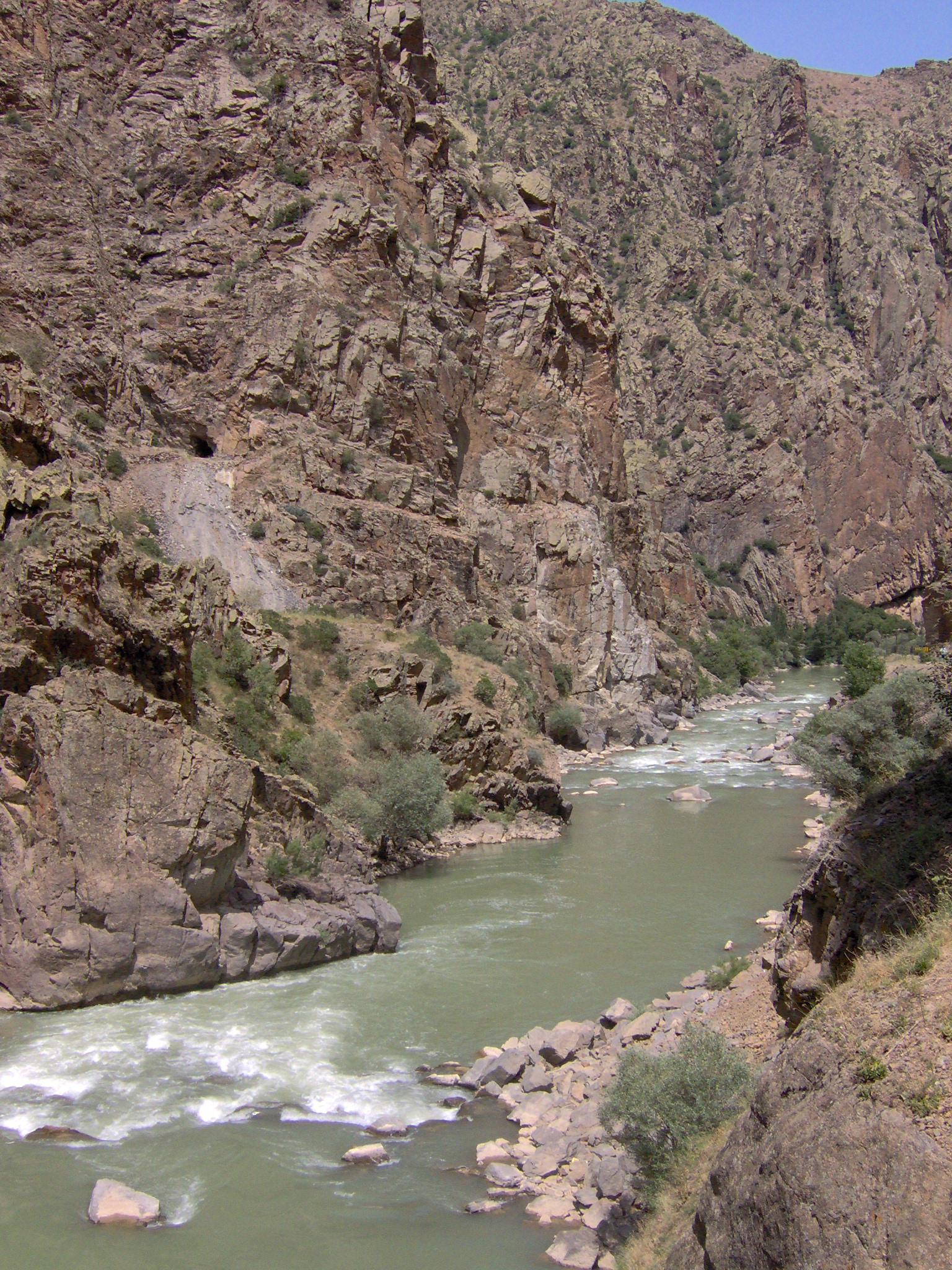
The Chorokh (Georgian: ჭოროხი Ch'orokhi, Turkish: Çoruh, Armenian: Չորոխ Ch’vorokh, Greek: Άκαμψις, Akampsis) is a river that rises in the Mescit Mountains in north-eastern Turkey, flows through the cities of Bayburt, İspir, Yusufeli, and Artvin, along the Kelkit-Çoruh Fault, before flowing into Georgia, where it reaches the Black Sea just south of Batumi and a few kilometers north of the Turkish-Georgian border.
| Çoruh Chorokh, Ch'orokhi, Acampsis | |
|---|---|
 | |
| Location | |
| Countries | Turkey and Georgia |
| Physical characteristics | |
| Source | |
| • location | Mescit Mountains |
| Mouth | Black Sea |
• coordinates | 41.6047°N 41.5742°E |
| Length | 438 km (272 mi)[1] |
| Basin size | 22,100 km2 (8,500 sq mi) |
| Discharge | |
| • average | 278 m3/s (9,800 cu ft/s) |
| Basin features | |
| Tributaries | |
| • right | Machakhelistsqali, Acharistsqali |
In Arrian's Periplus Ponti Euxini, it is called the Acampsis (Greek: Άκαμψις); Pliny may have confused it with the Bathys.[2] Procopius writes that it was called Acampsis because it was impossible to force a way through it after it has entered the sea, since it discharges its stream with such force and swiftness, causing a great disturbance of the water before it, that it goes out for a very great distance into the sea and makes it impossible to coast along at that point.[3]
In English, it was formerly known as the Boas, the Churuk, or the Chorokh.[4][5]
Biodiversity
The Ch'orokhi valley lies within the Caucasus ecological zone, which is considered by the World Wide Fund for Nature and by Conservation International as a biodiversity hotspot.[6][7] The Çoruh Valley is recognised by Turkish conservation organisations as an important plant area,[8] an important bird area,[9] a key biodiversity area[10] and has been nominated as a high priority area for protection. This valley is rich in plants and contains 104 nationally threatened plant species of which 67 are endemic to Turkey.[8]
Recreation
The Çoruh has been called "an eco-tourism gem" and "Turkey's last remaining wild river", and is being promoted for whitewater kayaking by the Eastern Anatolia Tourism Development Project.[11] It attracts kayakers and rafters from all over the world and was the site of the 4th World Rafting Championship in 1993[12] and the Coruh Extreme kayak competition in 2005.[13]

Dams
A total of 17 large hydroelectric dams are planned as part of the Çoruh River Development Plan[14] but a total of 27 are proposed for the Çoruh River Catchment. Under the Çoruh Development Plan, 8 dams have been completed (Arkun, Artvin, Borçka, Deriner, Güllübağ, Murtli, Tortum and Yusufeli Dams), another 2 are under construction.[15]
| Dam | Phase |
|---|---|
| Tortum Dam | Operational – Tortum River (Çoruh tributary) |
| Muratli Dam | Operational |
| Borçka Dam | Operational |
| Deriner Dam | Operational |
| Olur Dam | Planned |
| Bağlık Dam | Planned – Berta River (Çoruh tributary) |
| Bayram Dam | Planned – Berta River (Çoruh tributary) |
| Artvin Dam | Operational |
| Yusufeli Dam | Operational |
| Altiparmak Dam | Planned – Barhal River (Çoruh tributary) |
| Ayvali Dam | Planned – Oltu River (Çoruh tributary) |
| Olur Dam | Planned – Oltu River (Çoruh tributary) |
| Arkun Dam | Operational |
| Aksu Dam | Preliminary construction |
| Güllübağ Dam | Operational |
| İspir Dam | Planned |
| Laleli Dam | Under construction |
See also
References
- UN Economic Commission for Europe, Our waters: joining hands across borders : first assessment of transboundary, p. 150
- William Smith, Dictionary of Greek and Roman geography, 1:216 (1854).
- Procopius, History of the Wars, §8.2
- Encyclopædia Britannica, Eleventh Edition 2:757d
- W. Rickmer Rickmers, "Lazistan and Ajaristan", The Geographical Journal 84:6 (Dec., 1934), p. 466. at JSTOR
- WWF Global 200 Regions
- Conservation International Biodiversity Hotspots
- Ozhatay N, Byfield A & Atay S 2005, 122 Important Plant Areas of Turkey, for WWF Turkey, Istanbul, Turkey.
- Magnin G & Yarar M 1989, Important Bird Area in Turkey, Dogal Hayati Koruma Dernegi, Turkey.
- Eken G, Bozdogan M, I˙sfendiyaroglu S, Kılıç DT & Lise Y, (editörler) 2006, Key biodiversity areas in Turkey, Doga Dernegi, Ankara, Turkey.
- United Nations Development Programme: Europe & CIS, "Eastern Turkey Becomes Tourist Destination"
- Akkus, Cetin; Akkus, Gulizar (2019-01-17). Selected Studies on Rural Tourism and Development. Cambridge Scholars Publishing. p. 22. ISBN 9781527526013.
- Coruh Extreme Race
- ENCON 2006, ‘Yusufeli Dam and Hydroelectric Power Project Environmental Impact Assessment’, Ankara, Turkey.
- "Hydroelectric Power energy Resources" (PDF) (in Turkish). State Hydraulic Works. Retrieved 10 May 2013.
| Black Sea | |
|---|---|
| Marmara | |
| Aegean | |
| Mediterranean Sea | |
| Persian Gulf | |
| Caspian |
|
| |
| Authority control: National libraries |
|---|
На других языках
[de] Çoruh
Der Çoruh (türkisch) oder Tschorochi (georgisch ჭოროხი) ist ein 376 km langer Fluss, der am Mescit Dağı (3225 m) in der Provinz Erzurum in der nordöstlichen Türkei entspringt.- [en] Çoruh
[it] Çoruh
Il Çoruh (in turco Çoruh) o Chorokhi (in armeno Ճորոխ, Tchorokh; in georgiano ჭოროხი, Tch'orokhi; in greco Άκαμψις, Akampsis) è un fiume costiero caucasico del mar Nero che nasce e scorre prevalentemente in Turchia e sfocia in Georgia. Ha una lunghezza di 438 km - dei quali solo 22 scorrono in Georgia - e drena un bacino di 22.100 km², una superficie simile grossomodo a quella di paesi come El Salvador o Israele.[ru] Чорох
Чоро́х (Чору́х-Нехри[1], Чермелидере[2]; тур. Çoruh nehri; груз. ჭოროხი, Чорохи) — река в Турции (412 км) и Грузии (26 км). На реке расположены турецкие города — Артвин и Байбурт, центры одноимённых областей. Длина реки — 438 км.[источник не указан 57 дней] Средний расход воды — 285 м³/с.[источник не указан 57 дней]Другой контент может иметь иную лицензию. Перед использованием материалов сайта WikiSort.org внимательно изучите правила лицензирования конкретных элементов наполнения сайта.
WikiSort.org - проект по пересортировке и дополнению контента Википедии