geo.wikisort.org - River
The Kodori (Georgian: კოდორი; Abkhazian: Кәыдры, romanized: Kwydry) is one of the two largest rivers of Abkhazia,[1] along with the Bzyb. It is formed by the joining of the rivers Sakeni and Gvandra. The Kodori is first among Abkhazia's rivers with respect to average annual discharge at 144 cubic metres per second (5,100 cu ft/s) and drainage basin area at 2,051 square kilometres (792 sq mi). It is second after the Bzyb with respect to length at 105 kilometres (65 mi) when combined with the Sakeni.[2]
| Kodori | |
|---|---|
 | |
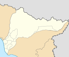
 Kodori river (in red) on the map of Georgia. | |
   | |
| Location | |
| Country | Georgia/Abkhazia[1] |
| Physical characteristics | |
| Source | Kelasuri First / Kelasuri Second |
| • location | Main Caucasian Range Caucasus Major |
| • elevation | 1,380 m (4,530 ft) |
| Mouth | Georgia/Abkhazia[1] |
• location | Black Sea |
• coordinates | 42°49′14″N 41°07′55″E |
• elevation | 0 ft (0 m) |
| Length | 105 km (65 mi) |
| Basin size | 2,051 square kilometres (792 sq mi) |
| Discharge | |
| • average | 144 m3/s (5,100 cu ft/s) |
See also
- Kodori Valley for the valley through which the Kodori flows.
References
Wikimedia Commons has media related to Kodori River.
- The political status of Abkhazia is disputed. Having unilaterally declared independence from Georgia in 1992, Abkhazia is formally recognised as an independent state by 6 UN member states (one other state recognised it but then withdrew its recognition), while Georgia continues to claim it as part of its own territory, designating it as Russian-occupied territory.
- Dbar, Roman (1999). "Geography & The Environment". In George Hewitt (ed.). The Abkhazians - a handbook. Caucasus World; Peoples of the Caucasus & the Black Sea. Richmond, Surrey: Curzon. ISBN 0-7007-0643-7.
This Abkhazia location article is a stub. You can help Wikipedia by expanding it. |
На других языках
[de] Kodori
Der Kodori (russisch Кодо́ри, Кодо́р .mw-parser-output .Latn{font-family:"Akzidenz Grotesk","Arial","Avant Garde Gothic","Calibri","Futura","Geneva","Gill Sans","Helvetica","Lucida Grande","Lucida Sans Unicode","Lucida Grande","Stone Sans","Tahoma","Trebuchet","Univers","Verdana"}Kodor, abchasisch Кәыдры, georgisch კოდორი) ist ein Fluss in der Autonomen Republik Abchasien im Nordwesten von Georgien.- [en] Kodori (river)
[es] Río Kodori
El río Kodor, Kodori o Kudri (en abjasio: Кәыдры, Kvidri; en georgiano: კოდორი, Kodori; en ruso: Кодор, Kodor) se encuentra ubicado en Georgia. Se forma de la confluencia entre los ríos Saken y Gvandra. Tiene una longitud de 105 kilómetros, nace a 3200 metros sobre el nivel del mar, baña una cuenca de 2051 km², y un caudal en su desembocadura de 144 m³/s.[ru] Кодор
Кодо́р[2][3][4], Кодо́ри[5] или Кудры́[6][7] (абх. Кәыдры [Кудры], груз. კოდორი [Кодори]) — река в Абхазии, впадающая в 20 километрах к юго-востоку от Сухума в Чёрное море.Текст в блоке "Читать" взят с сайта "Википедия" и доступен по лицензии Creative Commons Attribution-ShareAlike; в отдельных случаях могут действовать дополнительные условия.
Другой контент может иметь иную лицензию. Перед использованием материалов сайта WikiSort.org внимательно изучите правила лицензирования конкретных элементов наполнения сайта.
Другой контент может иметь иную лицензию. Перед использованием материалов сайта WikiSort.org внимательно изучите правила лицензирования конкретных элементов наполнения сайта.
2019-2026
WikiSort.org - проект по пересортировке и дополнению контента Википедии
WikiSort.org - проект по пересортировке и дополнению контента Википедии