geo.wikisort.org - River
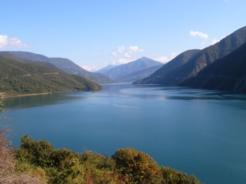
The Aragvi (Georgian: არაგვი) and its basin are in Georgia on the southern slopes of the Caucasus Mountains. The river is 112 kilometres (70 mi) long, and its basin covers an area of 2,740 square kilometres (1,060 sq mi).[3] The ground strata are mostly sandstone, slate, and limestone. The Zhinvali Dam and its 130 MW hydro-electric power station generate much of Georgia's power, and its construction in 1986 formed the Zhinvali Reservoir, upon whose north-western shores rises Ananuri castle with its 17th-century Church of the Assumption.
| Aragvi | |
|---|---|
 View upstream Aragvi River and along Tbilisi–Senaki–Leselidze highway (taken from around Jvari Monastery) | |
| Native name | არაგვი (Georgian) |
| Location | |
| Country | Georgia |
| Region | Caucasus |
| Physical characteristics | |
| Source | Caucasus |
| • location | Gudauri, Mtiuleti, Georgia |
| • coordinates | 42°20′41″N 44°41′42″E |
| • elevation | 1,045 m (3,428 ft)[1] |
| Mouth | flows into the Mtkvari (Kura) |
• location | Mtskheta, Georgia |
• coordinates | 41°50′24″N 44°43′34″E |
• elevation | 445 m (1,460 ft)[2] |
| Length | 112 km (70 mi) |
| Basin size | 2,740 km2 (1,060 sq mi) |
| Basin features | |
| Progression | Kura→ Caspian Sea |
Confusion over name and course
Given its etymology (see below; the word simply means "river"), the exact course of the Aragvi River is the source of some confusion. The river has several important tributaries, all called "aragvi":
The Tetri Aragvi ("White Aragvi")[4] flows from Gudauri down to the town of Pasanauri, where it is joined by the Shavi Aragvi ("Black Aragvi"),[5] the main river of Gudamakari to the north-east. Together, these two rivers continue as, simply, "the Aragvi"; from Pasanauri, the Aragvi flows south-east to the Jinvali Reservoir, where it is joined by the Pshav Aragvi[6] (itself fed by the Khevsur Aragvi)[7] before flowing south to merge with the Mtkvari by Mtskheta, Eastern Georgia's ancient capital just north of Tbilisi.
Etymology
See არაგვი for the origin of the name.
Use and infrastructure
The 102-metre (335 ft) high dam by Zhinvali is one of the largest in Georgia. Besides generating up to 130 MW of electricity, the waters of the Aragvi feed down a 36.7-kilometre (22.8 mi) pipe to provide drinking water in Tbilisi and to irrigate fields.
Gallery
 Zhinvali reservoir
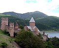 Ananuri castle
 Hydro-electric dam on the Aragvi
 The Source of The Aragvi River to the North of Gudauri


Notes
- Soviet General Staff Maps, 1:50,000 series, sheet K-38-54-W
- Soviet General Staff Maps, 1:50,000 series, sheet M-38-78-A
- Statistical Yearbook of Georgia: 2020, National Statistics Office of Georgia, Tbilisi, 2020, p. 12.
- Georgian: თეთრი არაგვი, tetri aragvi. Source: approx. 42°31'27.13"N, 44°24'2.40"E
- Georgian: შავი არაგვი, shavi aragvi. Source: approx. 42°27'25.18"N, 44°42'40.80"E
- Georgian: ფშავის არაგვი, pshavis aragvi. Source: approx. 42°23'57.01"N, 45°8'42.74"E
- Georgian: ხევსურეთის არაგვი, khevsuretis aragvi. Source: approx. 42°33'45.75"N, 44°57'12.78"E
Authority control | |
|---|---|
| General |
|
| National libraries | |
На других языках
[de] Aragwi
Der Aragwi (veraltet: die Aragua, georgisch არაგვი) ist ein 66 Kilometer (mit dem längeren Quellfluss 112 Kilometer) langer linker Nebenfluss der Kura im Nordosten Georgiens.- [en] Aragvi
[es] Río Aragvi
El río Aragvi y su cuenca está situada en Georgia, en la ladera sur de las montañas del Cáucaso. El río tiene 112 kilómetros de largo. La cuenca cubre un área de 2724 km² de estrato terroso, compuesto mayormente de arenisca, roca metamórfica y caliza. La Central hidroeléctrica construida en el río produce la mayor parte de la energía que consume Georgia. Fue construida la presa en 1986 y formó el embalse de Zhinvali.[1] Cerca del embalse se encuentra el castillo de Ananuri con la iglesia de la Asunción.[it] Aragvi
Il fiume Aragvi e il suo bacino idrografico è situato nella Georgia, sul versante meridionale della catena montuosa del Caucaso. Il fiume è lungo 112 km, mentre il bacino idrografico copre un'area di 2.724 km². Lo strato del suolo è in massima parte costituito da arenaria, ardesia e calcare. La diga della centrale idroelettrica costruita sul fiume produce molta energia per il fabbisogno della Georgia. Con la costruzione della diga nel 1986 si è venuto a formare il bacino idrico di Zhinvali.[1] Vicino a questa riserva idrica si trova il castello di Ananuri con la sua chiesa dell'Assunzione.[ru] Арагви
Ара́гви (груз. არაგვი) — река в восточной Грузии, левый приток Куры.Другой контент может иметь иную лицензию. Перед использованием материалов сайта WikiSort.org внимательно изучите правила лицензирования конкретных элементов наполнения сайта.
WikiSort.org - проект по пересортировке и дополнению контента Википедии