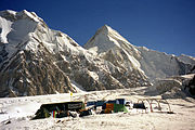
 South Inylchek Base Camp, at 4,000 m on the glacier's southern moraine, looking northwest to Chapaev Peak and Khan Tengri in the distance
 The peak appears on the 100 Kyrgyz som note
 Khan Tengri and Jengish Chokusu as seen from Chinese Provincial Road S313
geo.wikisort.org - Mountains
Khan Tengri is a mountain of the Tian Shan mountain range. It is on the China—Kyrgyzstan—Kazakhstan tripoint, east of lake Issyk Kul. Its geologic elevation is 6,995 m (22,949 ft), but its glacial icecap rises to 7,010 m (22,999 ft). For this reason, in mountaineering circles, including for the Soviet Snow Leopard award criteria, it is considered a 7,000-metre peak.
| Khan Tengri | |
|---|---|
| Hantengri Peak | |
 Khan Tengri above North Engilchek Glacier | |
| Highest point | |
| Elevation | 7,010 m (23,000 ft) |
| Prominence | 1,685 m (5,528 ft)[1] |
| Isolation | 19.46 km (12.09 mi) |
| Listing | Country high point Ultra |
| Coordinates | 42°12′39″N 80°10′30″E |
| Geography | |
 Khan Tengri Location in Kazakhstan, Kyrgyzstan, and Xinjiang respectively  Khan Tengri Khan Tengri (Kazakhstan)  Khan Tengri Khan Tengri (China)  Khan Tengri Khan Tengri (Xinjiang) | |
| Location | Ak-Suu District, Issyk-Kul Region, Kyrgyzstan Raiymbek District, Almaty Region, Kazakhstan Wensu County, Xinjiang, China |
| Parent range | Tian Shan |
| Climbing | |
| First ascent | 1931 Mikhail Pogrebetsky |
| Easiest route | glacier/snow/ice/rock climb |
Khan Tengri is the second-highest mountain in the Tian Shan, surpassed only by Jengish Chokusu (means "Victory peak", formerly known as Peak Pobeda) (7,439 m). Khan Tengri is the highest point in Kazakhstan and the third-highest peak in Kyrgyzstan, after Jengish Chokusu (7,439 m) and Avicenna Peak (7,134 m). It is also the world's most northern 7,000-metre peak, notable because peaks of high latitude have a shorter climbing season, generally more severe weather and thinner air.
Names
The name "Khan Tengri" literally means "King Heaven" in Kazakh or "King Sky" in Mongolian and possibly references the deity Tengri that both exist in Pagan Tengrism and Central Asian Buddhism. In some other local languages, it is known as Khan Tangiri Shyngy, Kan-Too Chokusu, Pik Khan-Tengry, and Hantengri Feng. (Mongolian: Хан Тэнгэр, Kazakh: Хан Тәңірі, Han Táńiri, حان تأڭئرئ; Kyrgyz: Хан-Теңири Han-Teñiri, حان-تەڭىرى; Uighur: خانتەڭرى; simplified Chinese: 汗腾格里峰; traditional Chinese: 汗騰格里峰; pinyin: Hànténggélǐ Fēng, Xiao'erjing: هًا تٍْ قْ لِ فعْ). Local residents named the mountain Khan-Tengri for the unique beauty of snow giants.
Features
Khan Tengri is a massive marble pyramid, covered in snow and ice. At sunset the marble glows red, giving it the name "blood mountain" in Kazakh and Kyrgyz (Kazakh: Қантау; Kyrgyz: Кан-Тоо). Located just across the South Engilchek (or Inylchek) glacier, 16 km north of Jengish Chokusu, Khan Tengri was originally thought to be the highest peak in the Tian Shan because of its dramatic, steep shape, compared to the massive bulk of Jengish Chokusu. This perception was probably also due to Khan Tengri's visibility across the plains of southern Kazakhstan while Jengish Chokusu remains out of view of civilization. Khan Tengri is the highest peak in the rugged Tengri Tag subrange, also known as the Mustag, that also contains Chapaev Peak (6,371 m, 20,902 ft) and Gorky Peak (6,050 m, 19,849 ft). Anatoli Boukreev considered Khan Tengri perhaps the world's most beautiful peak because of its geometric ridges and its symmetry.
History
Although it is almost 430 m (1,500 ft) lower than its neighbor, Khan Tengri was believed to be the highest peak in the range until Jengish Chokusu was surveyed in 1943 and determined to be higher.
Peter Semenov was the first European to see the Tengri Tag and its peak, the colossal Khan Tengri (in 1857).[2]
The first ascent of the peak was made in 1931 by Mikhail Pogrebetsky’s Ukrainian team through a route from the south (Kyrgyzstan side), then along the west ridge. M. Kuzmin's team made the first ascent from the north (Kazakhstan side) in 1964. Khan Tengri is one of five peaks that a Soviet mountaineer needed to scale to earn the prestigious Snow Leopard award.
Anatoli Boukreev achieved the first solo speed ascent in 1990.[citation needed]
A team from Kazakhstan made the first winter ascent of Khan Tengri on February 7, 1992; the team included Valery Khrichtchatyi, Viktor Dedi, Yuri Moiseyev, Valdimir Suviga, Aleksandr Savin, Igor Putintsev and Malik Ismetov.[3][4]
Austrian mountaineer and expedition leader Toni Dürnberger died while descending after having climbed Khan Tengri on 17 August 1992.[5]
In 2004, more than a dozen mountaineers were killed in a large avalanche on the Pogrebetsky route, the most popular route on the mountain.
The peak appears on the 100 Kyrgyz som note.
See also
- List of elevation extremes by country


Footnotes
- "The Central Asian Republics: Ultra-Prominence Page". Peaklist.org. Retrieved 2014-05-26. This prominence figure is based on the elevation of 6995m.
- Semenov, Petr Petrovitch. Travels in the Tian'-Shan' 1856-1857. Trans. by Liudmila Gilmour, Colin Thomas and Marcus Wheeler. Edited and annotated by Colin Thomas, pp. 180, 184-185. The Hakluyt Society, London. (1998). ISBN 0-904180-60-3.
- Khan Tengri, Tien Shan, First Winter Ascent
- http://www.alpinejournal.org.uk/Contents/Contents_1995_files/AJ%201995%20255-263%20Russia%20Central%20Asia.pdf Russia and Central Asia 1992-1994
- Video in Gedenken an den österreichischen Bergsteiger Toni Dürnberger
External links
- "Khan Tengri". SummitPost.org.
- "Khan Tengri". Peakware.com. Archived from the original on 2016-03-04.
- Khan Tengri route maps
- International Mountaineering Camp Kan Tengri
Kazakhstan articles | ||||||||||
|---|---|---|---|---|---|---|---|---|---|---|
| History |
|  | ||||||||
| Geography |
| |||||||||
| Politics |
| |||||||||
| Economy |
| |||||||||
| Culture |
| |||||||||
| ||||||||||
Authority control | |
|---|---|
| General |
|
| National libraries | |
На других языках
[de] Khan Tengri
Der Khan Tengri (mongolisch, „Khan des Himmels“ oder „Himmelsherrscher“; abgeleitet von altmongolisch: Khaghan-Tengri; türkisch: Tanrı Han) ist ein 7010 m hoher Berg im Tian-Shan-Gebirge in Zentralasien. Er ist als 7000er anerkannt, obwohl er ohne seine Eiskappe ein Felsgipfel von 6995 m wäre. Am Kulminationspunkt treffen die Grenzen Kasachstans, dessen höchster Gipfel er ist, Kirgisistans und Chinas aufeinander.- [en] Khan Tengri
[es] Khan Tengri
El Khan Tengri (uigur: Literalmente "Rey Cielo", traducido como "Señor de los espíritus" o "Señor del cielo") es una montaña en la cordillera Tian Shan. Se ubica en la frontera entre China, Kazajistán y Kirguistán, al este del lago Issyk Kul. Su elevación geológica es de 6.995 m, pero su glaciar se eleva a 7.010 m; por este motivo, el pico es considerado como un sietemil entre los miembros de la comunidad montañista. El pico es uno de los cinco que debe ser escalado para poder obtener el premio Leopardo de las Nieves.[fr] Khan Tengri
Le Khan Tengri est une montagne qui culmine à 7 010 mètres d'altitude dans le massif du Tian Shan, point culminant du Kazakhstan, à la frontière avec le Kirghizistan dont il est le troisième plus haut sommet, et très proche du Xinjiang en Chine[3]. Il est gravi pour la première fois en 1931 par Mikhail Pogrebetsky. Sommet particulièrement dangereux, son ascension est principalement tentée par des alpinistes russes et kazakhs.[it] Khan Tengri
Il Khan Tengri (in kazako: Хан Тәңірі?, traslitterato: Han Táńiri; in kirghiso: Хан-Теңири?, traslitterato: Xan-Teŋiri; in uiguro: خانتەڭرى; in cinese semplificato: 汗腾格里峰S, Hànténggélǐ FēngP), nome che in kazako significa "signore del cielo", è la montagna più alta del Kazakistan (7.010 m s.l.m.).[ru] Хан-Тенгри
Хан-Те́нгри (кирг. Кан-Теңири, каз. Хан Тәңірі, уйг. خان تېڭرى, кит. 汗腾格里峰) — пирамидальный пик на Тянь-Шане на хребте Тенгри-Таг на границе Киргизии, Казахстана, и Синьцзян-Уйгурского автономного района Китая. Высота — 7010 метров (с ледником), без учёта ледяной толщи[источник не указан 1402 дня] — 6995 м. Его название в переводе с тюркского означает «Повелитель неба».Текст в блоке "Читать" взят с сайта "Википедия" и доступен по лицензии Creative Commons Attribution-ShareAlike; в отдельных случаях могут действовать дополнительные условия.
Другой контент может иметь иную лицензию. Перед использованием материалов сайта WikiSort.org внимательно изучите правила лицензирования конкретных элементов наполнения сайта.
Другой контент может иметь иную лицензию. Перед использованием материалов сайта WikiSort.org внимательно изучите правила лицензирования конкретных элементов наполнения сайта.
2019-2026
WikiSort.org - проект по пересортировке и дополнению контента Википедии
WikiSort.org - проект по пересортировке и дополнению контента Википедии