geo.wikisort.org - Mountains
Slættaratindur (English: Flat peak) is the highest mountain in the Faroe Islands, at an elevation of 880 metres.[1] It is located in the northern part of Eysturoy, between the villages of Eiði, Gjógv, and Funningur. Funningur lies at the foot of the mountain, however, the summit is not visible from the village.
| Slættaratindur | |
|---|---|
 | |
| Highest point | |
| Elevation | 880 m (2,890 ft) |
| Prominence | 880 m (2,890 ft) |
| Coordinates | 62°17′47″N 7°00′45″W |
| Geography | |
 Slættaratindur Location of Slættaratindur in the Faroe Islands | |
| Location | Eysturoy, Faroe Islands |
Its name means "flat summit". It can be climbed in about four hours, and although the routes are steep, technical climbing skills are not necessary to reach the summit. In clear weather, the summit gives views over the entire archipelago. Slættaratindur is one of ten mountains in the Faroe Islands which rise to over 800m above sea level. Gráfelli, the second-highest peak at 856 m, lies just to the north-east of Slættaratindur.
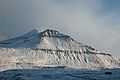 Slættaratindur during winter.
 Slættaratindur seen from the streets of Funningur.


References
 Definitions from Wiktionary
 Media from Commons
 News from Wikinews
 Quotations from Wikiquote
 Texts from Wikisource
 Textbooks from Wikibooks
 Resources from Wikiversity
Eiði Municipality | ||
|---|---|---|
| Populated places |
|  |
| Geographical features |
| |
| Sports | ||
| Energy |
| |
This Faroe Islands location article is a stub. You can help Wikipedia by expanding it. |
На других языках
[de] Slættaratindur
Der Slættaratindur (deutsch wörtlich: „flacher Gipfel“) ist mit 880 Metern[1][2] der höchste Berg der Färöer.- [en] Slættaratindur
[es] Slættaratindur
Slættaratindur es el punto más alto de las Islas Feroe con 880 m de altura.[1] Se encuentra en la parte norte de la isla de Eysturoy. Su nombre quiere decir " la cumbre plana ". Puede ser subido en aproximadamente cuatro horas, y aunque las rutas sean irregulares, no hace falta tener habilidades trepadoras para alcanzar la cumbre. Cuando hace buen tiempo la cumbre da vistas sobre el archipiélago entero. Slættaratindur es una de las diez montañas en las Islas Feroe que se elevan sobre 800 m encima del nivel de mar. Gráfelli, el segundo pico más alto con 856 m.[fr] Slættaratindur
Slættaratindur est le point culminant de l'archipel des îles Féroé, atteignant 880 m d'altitude[1].[it] Slættaratindur
Lo Slættaratindur è la montagna più alta delle Isole Fær Øer e raggiunge un'altitudine di 880 metri[1]; è situata nella parte settentrionale del distretto di Eysturoy, tra i villaggi di Eiði, Gjógv, e Funningur.[ru] Слаттаратиндур
Сла́ттаратиндур (фар. Slættaratindur) — высочайшая точка Фарерских островов.Другой контент может иметь иную лицензию. Перед использованием материалов сайта WikiSort.org внимательно изучите правила лицензирования конкретных элементов наполнения сайта.
WikiSort.org - проект по пересортировке и дополнению контента Википедии