geo.wikisort.org - Mountains
Kebnekaise (Swedish pronunciation: [kɛbnɛˈkâjsɛ];[3] from Sami Giebmegáisi or Giebnegáisi, "Cauldron Crest") is the highest mountain in Sweden. The Kebnekaise massif, which is part of the Scandinavian mountain range, has two main peaks. The glaciated southern peak used to be the highest at 2,120 metres (6,960 ft) above sea level, but has shrunk by 24 meters during the last 50 years,[4] making the northern icefree peak at 2,096.8 metres (6,879 ft) the highest. Kebnekaise lies in Swedish Lapland, about 150 kilometres (93 mi) north of the Arctic Circle and west of Kiruna near the Kungsleden hiking trail between Abisko and Hemavan.
| Kebnekaise (Swedish) Giebmegáisi (Northern Sami) | |
|---|---|
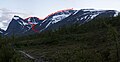
 Eastern slopes of Kebnekaise as seen from the Tarfala Valley | |
| Highest point | |
| Elevation | 2,096 m (6,877 ft)[1] |
| Prominence | 1,738 m (5,702 ft)[2] |
| Isolation | 756 to 758 km (470 to 471 mi) |
| Listing | Country high point Ultra |
| Coordinates | 67°54′16″N 18°31′42″E |
| Geography | |
 Sweden | |
| Parent range | Scandinavian Mountains |
| Climbing | |
| First ascent | 22 August 1883 by Charles Rabot |
| Easiest route | rock/ice walk; most popular route includes simple scrambling |
Geography
The Kebnekaise massif lies within a range of the Scandinavian mountains that is bordered by the glacial valleys Ladtjovagge (Sami spelling Láddjuvággi), Tjäktjavagge (Čeakčavággi) and Vistasvagge (Visttasvággi). The highest points of the massif lie along the ridge (called "Vargryggen" in Swedish) that runs from the southern and northern summits to Kebnepakte (Giebmebákti) at 1,990 metres (6,530 ft). Other subsidiary peaks are Kebnetjåkka (Giebmečohkka), Vierranvárri, Tolpagorni 1,662 metres (5,453 ft) , Guobircohkka 1,506 metres (4,941 ft), and Siŋŋibákti 1,614 metres (5,295 ft).
Of the two highest points, the southern peak lies on a glacier situated on a rocky plateau. The glacier has shrunk in recent years, and therefore the summit is not as high as earlier. The top was traditionally said to be 2,111 metres (6,926 ft), and higher in the oldest measurement, i.e. 2,117 metres (6,946 ft). If the melting continues at the same rate, the south peak will sink below the north peak (which is the highest fixed point in Sweden) within a few years' time.[5][6] However, as of July 2015, Tarfala Research Station reports that the glacier has grown by 4.5 to 2,102 metres (15 to 6,896 ft) — from its lowest measurement of 2,097.5 metres (6,882 ft) the previous year.[7]
The massif is heavily glaciated, with Kebnepakteglaciären, Isfallsglaciären, and Storglaciären towards Tarfala Valley to the east, Björlings glaciär to the southeast, and Rabots glaciär to the west, plus several smaller glaciers throughout the area.
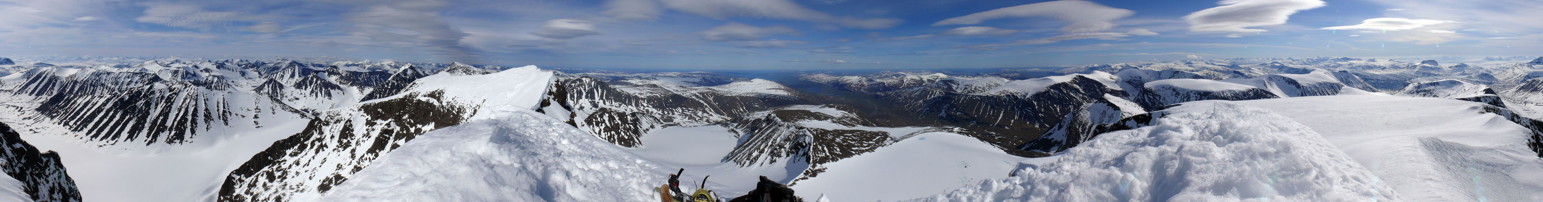
In Europe there are no higher mountains further north. During clear weather, a vast area can be seen from the summit, according to some sources as much as 10% of Sweden.[8]
Climbing routes
Kebnekaise mountain lodge (Kebnekaise fjällstation) is located to the southeast at the foot of Kebnekaise, about 19 kilometres (12 mi), 3–7 hours hike from the trailhead at Nikkaluokta (boat trip possible for 5 km). It is the starting point for an ascent to the south summit via the western route (västra leden, about 9 kilometres (5.6 mi), 5–7 hours to the summit) or the eastern route (östra leden, about 10 kilometres (6.2 mi), 3–5 hours to the summit). The western route leads over steep scree slopes and the intermediate peak Vierranvárri. Most of this route to the top is pure hiking, but there is a short exposed part that could possibly count as scrambling (YDS grade 2). The eastern route leads over glaciers and rocks and offers exposure (YDS grade 4). The steepest section is equipped with fixed steel cables for protection, similar to a via ferrata. There is also a third, less known route only marked with cairns — "Durlings led", which branches off Kungsleden a few kilometers north of Singi, goes about two kilometers into Singivagge, and then turns north into the valley between Kuopertjåkka and Siŋŋibákti. "Durlings led" eventually merges with the western route at "Kaffedalen", the pass between Vierranvárri and Kebnekaise. Advantages with this route are lack of exposure and a shorter ascent if Singivagge is used for an overnight camp. A fit hiker used in off track rock and scree walking can summit from the Kungsleden in good weather in about 6 hours up and 4-5 hours back down.
Just below the top plateau is an old smaller cabin at 1,880 metres (6,170 ft) altitude. A large cabin used to stand below the plateau, near the smaller one, until September 2018, when it was demolished by the county administration due to being too worn. A cabin up on the plateau was opened in 2016[9] as a replacement.[10]
The peak glacier is a small top, merely tens of meters high, on a rocky plateau. To approach the actual mountain top on the glacier, crampons or other means of enhancing traction may be required, depending on snow conditions. The glacier should be walked upon with great caution; fatal accidents have occurred with people sliding off into the huge void on the eastern side.[11] This danger might not always be apparent, even when there is good visibility.
Routes to the northern summit, including one via the narrow, icy arête from the southern summit, require mountaineering equipment and skills.
Due to the harsh subarctic climate[citation needed] at the location, Kebnekaise sees the vast majority of climbers during the summer months (late June to early September). However, Kebnekaise is also an established destination for winter alpinism and guided skiing tours are organised by the STF lodge's guides.
Climbing history
The first ascent to the summit was made on 22 August 1883 by an expedition led by Charles Rabot from France with the locals Jon Larsson, Hans Monsen and Peder Abrahamsson Lindgren. They started from the Skjomen fjord, Norway since the first railway in the region was built 1888. This was only published later. More media attention was given to the first Swedish expedition led by Johan Alfred Björling who summited on 9 July 1889.
The Kebnekaise mountain lodge was opened in 1908, starting more substantial tourism to the mountain.
The fastest ascent from the mountain lodge to the summit and back is 1:47:17 made on 9 July 2020 by Petter Engdahl.[12] The fastest woman is Emelie Forsberg in 2:00:40 done on 7 July 2014.
Norwegian military plane crash
On 15 March 2012 a RNoAF Lockheed Martin C-130J Super Hercules military aircraft crashed into the western snowy mountain side a short distance below the ridge that runs between the mountain's two highest peaks. Five Norwegian officers were killed.
Panorama
See also
- Storglaciären
- Tarfala research station
- Tarfala Valley
Gallery
 The western route marked with red dots.
![The oldest of the cabins close to the peak; standing at an 1880-meter altitude, built in 1924.[13]](//upload.wikimedia.org/wikipedia/commons/thumb/3/31/Kebnekaise_old_peak_cottage.jpg/120px-Kebnekaise_old_peak_cottage.jpg) The oldest of the cabins close to the peak; standing at an 1880-meter altitude, built in 1924.[13]
The oldest of the cabins close to the peak; standing at an 1880-meter altitude, built in 1924.[13] Mountaineers on Kebnekaise, early 20th century.
 The peak glacier seen from the trail, rising from a nearly flat plateau.

![The oldest of the cabins close to the peak; standing at an 1880-meter altitude, built in 1924.[13]](http://upload.wikimedia.org/wikipedia/commons/3/31/Kebnekaise_old_peak_cottage.jpg)


References
- Tarfala Research Station. "Kebnekaise Southern Summit Elevation". hdl:11676.1/2jVbFrAZisV44hwgrbSLzY6Z.
- "Mountains I have climbed and remember". uib.no.
- "Word: Kebnekaise: Pronunciation in Swedish". Forvo: All the words of the world. Pronounced. Retrieved 29 January 2014.
- Tarfala Research Station. "Kebnekaise Southern Summit Elevation". hdl:11676.1/2jVbFrAZisV44hwgrbSLzY6Z.
- Malin Olofsson, "Toppskifte på Kebnekaise" Archived 2007-09-30 at the Wayback Machine, Sveriges Radio, 15 June 2007, retrieved 27 March 2012 (in Swedish)
- Kebnekaises sydtopp – högst i Sverige? Archived 2007-09-28 at the Wayback Machine, fjallklubben.org (broken link)
- Emil Östlund, "Sydtoppen växer på Kebnekaise", Sveriges Radio 23 July 2015, retrieved 27 October 2015 (in Swedish)
- "Reportage". swedenoffroad.com. Archived from the original on 2015-04-18. Retrieved 2013-08-16.
- "Ny toppstuga på Kebnekaise".
- "Kebnekaises toppstuga nedbränd – NSD". 7 September 2018.
- "Fjällvandrare föll 400 meter". Aftonbladet.
- "Kebnekaise (Sweden)".
- "Toppstugorna > Boende > Kebnekaise". kebnekaise.nu. Archived from the original on 2012-08-14.
External links
| Wikimedia Commons has media related to Kebnekaise. |
| Wikivoyage has a travel guide for Kebnekaise. |
- Photo gallery on Marco Klüber Photography
- Ski touring reports from Swedish mountains, including Kebnekaise (English)
Authority control | |
|---|---|
| General | |
| National libraries | |
На других языках
[de] Kebnekaise
Der Kebnekaise (samisch Giebnegáisi oder Giebmegáisi, auf deutsch etwa „Kessel-Kamm“) ist mit 2097 Metern (Nordgipfel, bestehend aus Fels) der höchste Berg Schwedens. Früher war der vergletscherte Südgipfel höher als der Nordgipfel;[1] (er wird seit 1880 vermessen); 2018 war er, bedingt durch die globale Erwärmung und die dadurch bedingte Gletscherschmelze, erstmals niedriger als der Nordgipfel.[2]- [en] Kebnekaise
[es] Kebnekaise
El monte Kebnekaise (del sami Giebmegáisi o Giebnegáisi) es la montaña más alta de Suecia. El macizo del Kebnekaise, que forma parte de los Alpes escandinavos, tiene dos picos, de los cuales el de más al sur alcanzaba los 2103 metros sobre el nivel del mar y está permanentemente cubierto por hielo, pero ha visto reducida su altitud 24 m por el deshielo desde la década de 1960; el de más al norte, con 2097 metros y rocoso, es actualmente el pico más alto.[1][2][fr] Kebnekaise
Le Kebnekaise, en same Giebmegáisi ou Giebnegáisi, littéralement « rebord du chaudron », est un sommet de Suède, point culminant du pays avec 2 097 mètres d'altitude. Bien que situé dans une région reculée dans le nord du pays, il constitue un but de randonnée populaire.[it] Kebnekaise
Kebnekaise (dalla lingua dei Sami Giebmegáisi o Giebnegáisi) è la più alta montagna della Svezia. Il massiccio, che fa parte delle montagne scandinave, ha due cime. Quella nella parte sud, quella ghiacciata, è la più alta, 2103 m s.l.m. (sopra il livello del mare). La cima a nord (2097 m s.l.m.), non è coperta da ghiacci. Il Kebnekaise si trova in Lapponia, circa 150 chilometri a nord del circolo polare artico e ad ovest del centro abitato di Kiruna, dove passa la linea ferroviaria che termina a Narvik.[ru] Кебнекайсе
Ке́бнекайсе (швед. Kebnekaise, от сев.‑саам. Giebmegáisi или Giebnegáisi — «котловая вершина») — гора в Скандинавских горах.Другой контент может иметь иную лицензию. Перед использованием материалов сайта WikiSort.org внимательно изучите правила лицензирования конкретных элементов наполнения сайта.
WikiSort.org - проект по пересортировке и дополнению контента Википедии