geo.wikisort.org - Mountains
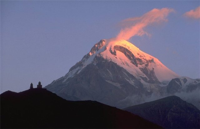
Mount Kazbek or Mount Kazbegi is a dormant stratovolcano and one of the major mountains of the Caucasus, located on the Russian-Georgian border - in Russia's North Ossetia region and Georgia's Kazbegi District.[4]
| Mount Kazbek | |
|---|---|
 Mount Kazbek | |
| Highest point | |
| Elevation | 5,054 m (16,581 ft)[1][2] |
| Prominence | 2,353 m (7,720 ft)[1] |
| Listing | Ultra |
| Coordinates | 42°41′57″N 44°31′06″E[1] |
| Naming | |
| Native name |
|
| Geography | |
Kazbegi Location of Mount Kazbegi within the Caucasus Mountains  Kazbegi Kazbegi (Mtskheta-Mtianeti) | |
| Location |
|
| Countries | Russia and Georgia |
| Parent range | Lateral Range Caucasus |
| Geology | |
| Mountain type | Stratovolcano (dormant) |
| Last eruption | 750 BCE ± 50 years |
| Climbing | |
| First ascent | 1868 by Douglas Freshfield, A. W. Moore, C. C. Tucker and François Devouassoud |
| Easiest route | Basic snow/ice climb |
Mount Kazbek is one of 10 highest peaks in Russia and the third-highest peak in Georgia (after Mount Shkhara and Janga) and the seventh-highest summit in the Caucasus Mountains. Kazbegi is also the second-highest volcanic summit in the Caucasus, after Mount Elbrus. The summit lies directly to the west of the town of Stepantsminda and is the most prominent geographic feature of the area. The name Kazbeg is disputed; some claims are it is named after a Circassian nobleman who lived on it, other claims are it is named after local nobleman Dimitri Chopikashvili (grand father of the Georgian writer Aleksandre Kazbegi) got the title of "Kazgeb" from Georgian king Erekle II. The word "Kazbek" means a "nobleman" in Kabardian language. The title appeared under Georgian king Rostom in the 17th century. The name of the mountain in Georgian, Mqinvartsveri, translates to "Glacier Peak" or "Freezing Cold Peak".[5] The Vainakh name Bashlam translates as "Molten Mount".
Location
Kazbek is located on the Khokh Range, a mountain range which runs north of the Greater Caucasus Range, and which is pierced by the gorges of the Ardon and the Terek. At its eastern foot runs the Georgian Military Road through the pass of Darial 2,378 meters (7,805 feet).[6] The mountain itself lies along the edge of the Borjomi–Kazbegi Fault (which is a northern sub-ending of the North Anatolian Fault). The region is highly active tectonically, with numerous small earthquakes occurring at regular intervals. An active geothermal/hot spring system also surrounds the mountain. Kazbek is a potentially active volcano, built up of trachyte and sheathed with lava, and has the shape of a double cone, whose base lies at an altitude of 1,770 meters (5,800 feet).[6] Kazbek is the highest of the volcanic cones of the Kazbegi volcanic group which also includes Mount Khabarjina (3,142 metres).
Owing to the steepness of its slopes, the glaciers of Kazbek are not very large.[6] The total combined area of all of Kazbek's glaciers is 135 km2. The best-known glacier is the Dyevdorak (Devdaraki), which creeps down the north-eastern slope into a gorge of the same name, reaching a level of 2,295 meters (7,530 feet). Kazbegi's other glaciers include the Mna, Denkara, Gergeti, Abano, and Chata. The recent collapse of the Kolka Glacier, located in a valley between Mt. Jimara and Kazbegi in the year 2002 was attributed to solfatara volcanic activity along the northern slope of the mountain, although there was no eruption. In addition to the 2002 event, a massive collapse of the Devdaraki Glacier on the mountain's northeastern slope which occurred on August 20, 2014, led to the death of seven people. The glacier collapse dammed the Terek River in the Daryal Gorge and flooded the Georgian Military Highway.
From 24 to 28 May 2019 Caucasus Skitouring Network organized an expedition to survey Mt. Kazbegi's height. On 27 May 2019 at 12:22 GMT+4, for the first time, a survey team placed a GPS receiver on the Mt. Kazbegi peak. The new height is defined with the WGS 84 datum. Height was determinate with 5mm accuracy. Defined height is 5053.927m.
Legend
Mount Kazbegi is associated in Georgian folklore with Amirani, the Georgian version of Prometheus, who was chained on the mountain in punishment for having stolen fire from the gods and giving it to mortals. The location of his imprisonment later became the site of an Orthodox hermitage located in a cave called "Betlemi" (Bethlehem) at approximately the 4,000-meter level. According to legends, this cave housed many sacred relics, including Abraham's tent and the manger of the infant Jesus.[7]
The summit was first climbed in 1868 by D. W. Freshfield, A. W. Moore, and C. Tucker[6] of the Alpine Club, with the guide François Devouassoud. They were followed by female Russian alpinist Maria Preobrazhenskaya, who made the climb nine times starting in 1900.
Kazbegi nature reserve
The area around Mount Kazbegi was designated a nature reserve by the Soviet government in 1979, and includes beech forests, subalpine forests and alpine meadows. Many of the plants and animals in the reserve are endemic to the Caucasus region.
Climate
| Climate data for Kazbek, 5033 m asl (1981–2010 normals) | |||||||||||||
|---|---|---|---|---|---|---|---|---|---|---|---|---|---|
| Month | Jan | Feb | Mar | Apr | May | Jun | Jul | Aug | Sep | Oct | Nov | Dec | Year |
| Record high °C (°F) | −1.5 (29.3) |
8.0 (46.4) |
2.0 (35.6) |
8.0 (46.4) |
7.8 (46.0) |
14.0 (57.2) |
20.0 (68.0) |
21.0 (69.8) |
15.0 (59.0) |
8.8 (47.8) |
14.7 (58.5) |
8.0 (46.4) |
21.0 (69.8) |
| Average high °C (°F) | −10.9 (12.4) |
−9.0 (15.8) |
−7.3 (18.9) |
−3.3 (26.1) |
−0.2 (31.6) |
4.7 (40.5) |
6.9 (44.4) |
7.9 (46.2) |
4.4 (39.9) |
−0.6 (30.9) |
−2.8 (27.0) |
−6.9 (19.6) |
−1.4 (29.4) |
| Daily mean °C (°F) | −14.0 (6.8) |
−12.3 (9.9) |
−10.2 (13.6) |
−6.4 (20.5) |
−2.5 (27.5) |
1.7 (35.1) |
4.6 (40.3) |
5.5 (41.9) |
2.1 (35.8) |
−3.9 (25.0) |
−6.0 (21.2) |
−10.7 (12.7) |
−4.3 (24.2) |
| Average low °C (°F) | −17.1 (1.2) |
−15.6 (3.9) |
−13.0 (8.6) |
−9.6 (14.7) |
−4.8 (23.4) |
−1.4 (29.5) |
2.3 (36.1) |
3.0 (37.4) |
−0.2 (31.6) |
−7.0 (19.4) |
−9.2 (15.4) |
−14.4 (6.1) |
−7.3 (18.9) |
| Record low °C (°F) | −24.9 (−12.8) |
−28 (−18) |
−28 (−18) |
−20.4 (−4.7) |
−11 (12) |
−11.2 (11.8) |
−4 (25) |
−5 (23) |
−14 (7) |
−16 (3) |
−18 (0) |
−27 (−17) |
−28 (−18) |
| Average precipitation mm (inches) | 88.0 (3.46) |
68.1 (2.68) |
56.8 (2.24) |
73.4 (2.89) |
123.3 (4.85) |
75.3 (2.96) |
96.9 (3.81) |
99.8 (3.93) |
65.5 (2.58) |
82.0 (3.23) |
107.0 (4.21) |
73.8 (2.91) |
1,009.9 (39.75) |
| Average precipitation days (≥ 1 mm) | 8.1 | 6.5 | 6.9 | 9.4 | 13.6 | 11.6 | 10.6 | 8.7 | 10.0 | 10.3 | 10.0 | 8.3 | 114 |
| Source 1: Météo climat stats[8] | |||||||||||||
| Source 2: Météo Climat [9] | |||||||||||||
See also
- Highest points of Russian Federal subjects
- List of volcanoes in Georgia (country)
Image gallery
 19th-century postcard of the Georgian Military Road near Mount Kazbegi
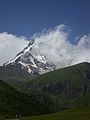 Mount Kazbek from the outside of the Gergeti Trinity Church
 Kazbegi Mountain, August 2019


 Gergeti glacier


References
- "European Russia and the Caucasian States: Ultra-Prominence Page". peaklist.org. Retrieved 2014-05-25.
- "Gora Kazbek, Georgia". Peakbagger.com. Retrieved 2015-05-25.
- Страны Мира. ОЛМА Медиа Групп. p. 168. ISBN 978-5-94849-423-4.
- "Kazbek". Global Volcanism Program. Smithsonian Institution. Retrieved 2021-06-24.
- "მყინვარი", Donald Rayfield et al., A Comprehensive Georgian-English Dictionary (2006)
- This article incorporates text from a publication now in the public domain: Chisholm, Hugh, ed. (1911). "Kasbek". Encyclopædia Britannica. Vol. 15 (11th ed.). Cambridge University Press. p. 685.
- Georgia: A Sovereign Country of the Caucasus. Odyssey Publications: Hong Kong. 1999. ISBN 962-217-748-4.
- "Moyennes 1981-2010 Géorgie" (in French). Retrieved 11 November 2019.
- "Météo Climat stats for Kazbek". Météo Climat. Retrieved 11 November 2019.
External links
- "Mount Kazbek". Peakware.com. Archived from the original on 2016-03-04. – photos
- Normal climbing route to Mount Kazbek – detailed description
- Different ways to climb mt Kazbek – detailed description
Authority control | |
|---|---|
| General | |
| National libraries | |
На других языках
[de] Kasbek
Der Kasbek (georgisch მყინვარწვერი .mw-parser-output .Latn{font-family:"Akzidenz Grotesk","Arial","Avant Garde Gothic","Calibri","Futura","Geneva","Gill Sans","Helvetica","Lucida Grande","Lucida Sans Unicode","Lucida Grande","Stone Sans","Tahoma","Trebuchet","Univers","Verdana"}Mqinwarzweri, „Eisgipfel“ auch georgisch ყაზბეგი Qasbegi) ist der dritthöchste Berg Georgiens und der achthöchste Berg des Großen Kaukasus. Über seinen Gipfel verläuft die Staatsgrenze zwischen Georgien, Region Mzcheta-Mtianeti, und Russland, Republik Nordossetien-Alanien.- [en] Mount Kazbek
[es] Monte Kazbek
El monte Kazbek es un estratovolcán de 5.047 m altitud que se encuentra en Georgia, cerca de la frontera con la república de Osetia del Norte que forma parte de la Federación rusa. Es la cuarta cumbre de las montañas del Cáucaso, que tiene su cumbre más elevada en el monte Elbrus, y, es el segundo pico más alto en Georgia.[fr] Mont Kazbek
Le mont Kazbek (en géorgien : ყაზბეგი) est un sommet et volcan endormi culminant à 5 047 mètres d'altitude en Géorgie, près de la frontière avec la Russie. C'est la cinquième plus haute montagne du Caucase et la deuxième de Géorgie après le mont Chkhara. Il est couvert de glaciers et son ascension ne présente que des difficultés moyennes. Il a été gravi pour la première fois le 1er juillet 1868 par Douglas William Freshfield, Adolphus Warburton Moore et Charles Comyns Tucker.[it] Monte Kazbek
Il monte Kazbek (in russo: Казбек?; in georgiano: მყინვარწვერი?, traslitterato: Mqinvartsveri) è una montagna della Catena del Caucaso di 5 047 m, al confine tra la Russia e la Georgia[1].[ru] Казбек
Казбе́к (груз. მყინვარწვერი; осет. Сӕнайы хох; ингуш. Бешлоамкорта) — потенциально активный[2] стратовулкан[3], самый восточный пятитысячник Кавказа, высота в Балтийской системе высот 5033,8 м[1]. Расположен в восточной части Центрального Кавказа, на границе России и Грузии, в восточной части Хохского хребта[4]. Последнее извержение произошло в 650 году до н. э.[3]Другой контент может иметь иную лицензию. Перед использованием материалов сайта WikiSort.org внимательно изучите правила лицензирования конкретных элементов наполнения сайта.
WikiSort.org - проект по пересортировке и дополнению контента Википедии