geo.wikisort.org - Mountains
Rodna Mountains (Romanian: Munții Rodnei, Hungarian: Radnai-havasok) are a subdivision of the Inner Eastern Carpathians in northern Romania. The name comes from the nearby Rodna Veche village. At 2,303 metres (7,556 feet), Pietrosul Rodnei is the highest peak in all of the Eastern Carpathians.[1]
This article includes a list of references, related reading or external links, but its sources remain unclear because it lacks inline citations. (September 2015) |
| Rodna Mountains | |
|---|---|
| Romanian: Munții Rodnei | |
 | |
| Highest point | |
| Peak | Pietrosul Rodnei |
| Elevation | 2,303 m (7,556 ft) |
| Coordinates | 47.538°N 24.6972°E |
| Dimensions | |
| Length | 50 km (31 mi) |
| Width | 25 km (16 mi) |
| Area | 1,300 km2 (500 sq mi) |
| Geography | |

| |
| Country | Romania |
| Counties | Bistrița-Năsăud, Maramureș |
| Parent range | Inner Eastern Carpathians |
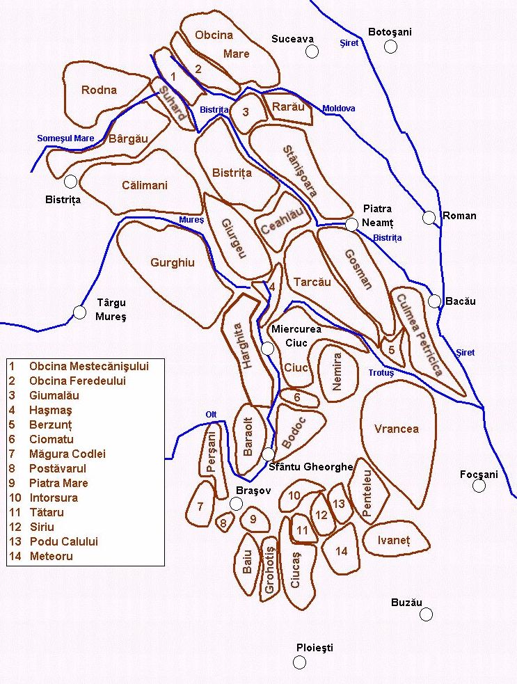
The main ridge of the Rodna Mountains constitutes the natural border between Bistrița-Năsăud and Maramureș counties. From an administrative point of view, 80% of the massif's surface is in Bistrița-Năsăud and 20% in Maramureș.[1]
Geography
The Rodna Mountains have one of the longest continuous ridges in Romania, with over 50 km (31 mi) from west to east and a width of over 25 km (16 mi). The massif covers an area of about 1,300 km2 (500 sq mi).[1] The highest points are Pietrosul Rodnei at 2,303 m, Ineu Peak at 2,279 m (7,477 ft), Ineuț Peak at 2,202 m (7,224 ft), Gârgalău Peak at 2,159 m (7,083 ft), and Omu Peak at 2,010 m (6,590 ft).
The mountains are most suited for hiking in summer and skiing in winter, and are especially famous for having snow late into the summer months (skiing is possible well into June, sometimes even July). While the ridge itself poses no difficulties, the challenge is the massive length of it, and the absence of drinkable water (except for a few puddles that are usually dry). A complete hike along the main Rodnei ridge takes between 3 and 5 days, depending on the weather and the endurance of the hiker.

The massif has some caves, notable among them being Izvorul Tăușoarelor, the deepest cave in Romania, reaching about 479 m (1,572 ft) beneath the surface and Jgheabul lui Zalion, 242 m (794 ft) deep.
Location

The Rodna Mountains are partly in the region of Maramureș, in northern Romania, near the Romania–Ukraine border. To the north lies the town of Borșa and the village Moisei.
To the west the massif ends at the Șetref Pass (817 m (2,680 ft)), which connects it to the Transylvanian Plateau.
To the east are the Suhard Mountains; the river Bistrița has its source here, in a cirque at the foot of the Gârgalău Peak. The Prislop Pass (1,416 m (4,646 ft)) and the Rotunda Pass (1,271 m (4,170 ft)) connect the Rodna Mountains to Western Moldavia.
To the south lie the villages Rodna, Șanț, Maieru, and Anieș and the town of Sângeorz-Băi, in Bistrița-Năsăud County. The Someșul Mare River has its source in the Rodna Mountains and separates them from the Bârgău Mountains.
Access

The most used access points to the mountain are:
- Șetref Pass, by car or train, from the Dealu Ștefăniței train station.
- Borșa city, by car or bus; from the center of the city there is a path to the Iezer weather station and lake.
- Borșa ski resort, by car or bus; access is made from the top of the ski slope, directly to the main ridge at "Șaua Gărgălău".
- Prislop Pass, by car; from the pass there is a marked path that meets the one from the top of the ski slope, also leading to "Șaua Gărgălău".
- Rodna Veche village, by train or car; from the village there are two marked paths leading to the main ridge, one of them going directly to the Ineu Peak.
Accommodation

There are a few resorts at the base of the mountain, notably Borșa ski resort, with a few hotels and many privately run guesthouses, and also the new "Valea Blaznei" resort, completed in 2007, near the village Șanț. It contains two notable places to stay, "Cabana Vio" at 1,100 m (6 km from Șanț village), and a bit higher, "Cabana Diana" at 1,240 m, which is a mountain refuge. Up on the ridge there is no accommodation whatsoever, so tourists should bring tents.
Nature reserve
The entire Rodna Mountain is included in the Rodna National Park and Biosphere Reserve. This is a 567 km2 (219 sq mi) reservation in the Eastern Carpathians with brown bears, lynx, gray wolves, black capercaillies, and eagles.
References
- "Acasă – în Munții Rodnei". www.rodnei.ro (in Romanian). Retrieved November 25, 2021.
External links
- "Munții Rodnei – cei mai înalți munți din Carpații Orientali". romaniasalbatica.ro (in Romanian). Retrieved November 25, 2021.
- "Legenda cumplită din Munții Rodnei" (in Romanian). Digi24. July 15, 2017. Retrieved November 25, 2021.
- "Hírek". www.radnaihavasok.ro (in Hungarian). Retrieved November 25, 2021.
- "Pohoří Rodna (Munții Rodnei)". karpaty.prygl.net (in Czech). Archived from the original on 2008-02-10. Retrieved November 25, 2021.
Authority control | |
|---|---|
| General |
|
| National libraries | |
На других языках
[de] Rodnaer Gebirge
Das Rodnaer Gebirge, auch Rodna-Gebirge (rumänisch Munții Rodnei) liegt im Norden Rumäniens. Das Gebirgsmassiv hat eine Länge von 50 km in westöstlicher Richtung. Es gehört zur nördlichen Gebirgsgruppe der Ostkarpaten. 46.399 Hektar des Rodna-Gebirges stehen unter Naturschutz. Der Nationalpark Rodna-Gebirge ist der größte Nationalpark in Rumänien.- [en] Rodna Mountains
[es] Macizo de Rodna
Los montes Rodna (Munţii Rodnei) forman parte de los Cárpatos orientales en el norte de Rumania. Su cumbre más alta, Pietrosul Rodnei, alcanza los 2.303 msnm. La cadena se extiende a lo largo de 50 km de largo y 35 km de ancho, siendo su vertiente norte más escarpada. Posee algunos lagos de montaña y algunas cuevas, como Izvorul Tăuşoarelor, la cueva más profunda de Rumania (479 m) y Jgheabul lui Zalion (242 m).[fr] Monts Rodna
Les monts Rodna (Munții Rodnei en roumain) font partie des Carpates orientales dans le Nord de la Roumanie. Leur plus haut sommet, Pietrosul Rodnei, atteint 2 303 mètres d'altitude. La chaîne s'étend sur environ 50 kilomètres en longueur et 35 kilomètres en largeur, avec un versant septentrional plus escarpé. Il possède quelques lacs alpestres et quelques grottes notables, dont Peștera Izvorul Tăușoarelor (ro), la grotte la plus profonde de Roumanie (479 mètres) et Jgheabul lui Zalion (242 mètres).[ru] Родна
Ро́дна[1] (рум. Munții Rodnei) — горный массив в Карпатах, расположен на севере Румынии около границы с Украиной.Другой контент может иметь иную лицензию. Перед использованием материалов сайта WikiSort.org внимательно изучите правила лицензирования конкретных элементов наполнения сайта.
WikiSort.org - проект по пересортировке и дополнению контента Википедии