geo.wikisort.org - Mountains
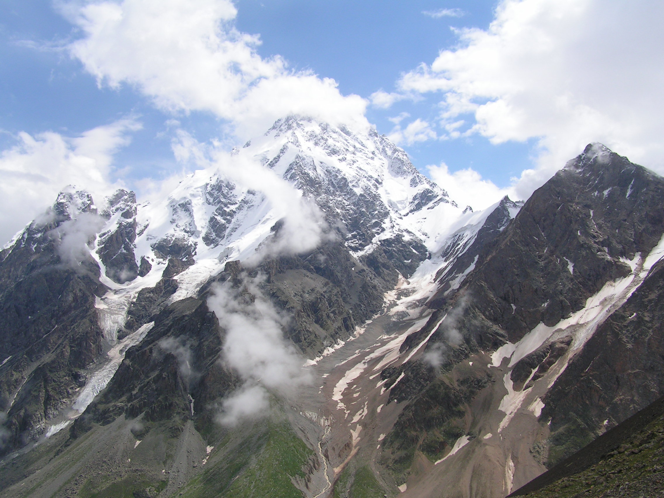
Dykh-Tau or Dykhtau (Russian: Дыхтау, Karachay-Balkar: Дых тау that is derived from Turkic "dik dagh" which means Jagged Mount), is a mountain located in Kabardino-Balkaria, Russia; its peak stands about 5 km (3 mi) north of the border with Georgia.[citation needed]
| Gora Dykh-Tau | |
|---|---|
 | |
| Highest point | |
| Elevation | 5,205 m (17,077 ft) |
| Prominence | 2,002 m (6,568 ft) |
| Isolation | 64 km (40 mi) |
| Listing | Seven Second Summits Ultra |
| Coordinates | 43°3′N 43°8′E |
| Geography | |
Gora Dykh-Tau Location of Dykh-Tau in the Caucasus mountains 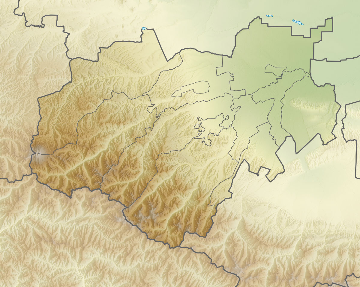 Gora Dykh-Tau Gora Dykh-Tau (Kabardino-Balkaria) | |
| Location | Kabardino-Balkaria, Russia |
| Country | Russia |
| Parent range | Lateral Range Caucasus Mountains |
| Topo map | Map and Guide to the Caucasus: Bezingi, Bashil, Adaikhokh[1] |
Access
Dykh-Tau is best accessed from the north (Russia). Bezingi village may be reached from Nalchik in Kabardino-Balkaria with infrequent public transport, here a 4WD vehicle must be hired. Thus Bezingi Alpine Camp is reached at 2,180 meters (7,150 ft). From here it takes a further 2 days to reach the base of the climb.[2]
Climbing routes
This is one of the Caucasian Peaks, facing the Bezingi Wall across the Bezingi Glacier. The first ascent in 1888 by Albert Mummery and Heinrich Zurfluh of Meiringen was a major achievement at the time.[3] Their route up the SW Ridge is no longer used as the normal route which is now the North Ridge graded 4B (Russian Grading).[citation needed]
Starting from Misses Kosh the ridge is accessed by crossing the West Ridge of Misses-Tau then continuing to the Russian Bivouac located by a hanging glacier descending from the North Ridge of Dykhtau, 4 hours from Misses-Kosh. Once a notch between Misses-Tau and Dykhtau is gained, the North Ridge is followed to the summit. Allow 2 and a half days from the Russian Bivouac, there are several good bivouac sites on the North Ridge (Details and map).
Mapping
Various Soviet military maps annotated in the Cyrillic script can found on the internet; two of the maps cover the Dykhtau area.[1]
References
- Map and Guide to the Caucasus: Bezingi, Bashil, Adaikhokh (Map) (1st ed.). 1:100,000 with mountaineering information. Cartography by EWP. EWP/WCP. 1994. ISBN 0-906227-53-4.
- Caucasus from Elbrus to Kazbek (Map) (1st ed.). 1:200,000 with general information. Map Guides. Cartography by EWP. Robin Collomb and Andrew Wielochowski. 1992. ISBN 0-906227-54-2.
- Mummery, Albert. – via Wikisource.
External links
- "Gora Dykh-Tau, Russia". Peakbagger.com.
- summitpost.org: Dykhtau
На других языках
[de] Dychtau
Der Dychtau (russisch Дыхтау; auch Dykh Tau, Dikh Tau oder Dycktau) ist ein Berg im Großen Kaukasus. Sofern man den Großen Kaukasus nördlich des Hauptkammes zu Europa zählt, ist er mit 5204 m Höhe nach dem Elbrus der zweithöchste Gipfel Europas.- [en] Dykh-Tau
[es] Monte Dij-Tau
Dij-Tau, Dykh-Tau o Dykhtau es un montaña del Cáucaso ubicada en Kabardino-Balkaria, Rusia. Su cumbre está a unos 5 km de la frontera con Georgia. Es el segundo pico más alto del Cáucaso y de Europa, después del monte Elbrus.[fr] Dykh-Taou
Le Dykh-Taou (ou Dykhtau) est une montagne culminant à 5 205 mètres d'altitude en Kabardino-Balkarie, une république caucasienne de Russie. Il se situe dans le versant septentrional du Grand Caucase, au nord de la frontière géorgienne, et constitue le deuxième plus haut sommet de l'Europe et de la Russie après l'Elbrouz. Il est gravi pour la première fois en 1888 par l'arête sud-ouest. La voie normale, ouverte la même année, passe désormais par l'arête nord. La montagne est protégée par la réserve naturelle de haute montagne de Kabardino-Balkarie.[it] Dych-Tau
Il monte Dych-Tau o Dychtau (in russo: Дыхта́у? o Дых-тау) è una vetta di 5205 metri nella catena del Caucaso.[ru] Дыхтау
Дыхта́у (карач.-балк. Дых тау — «крутая гора») — горная вершина Бокового хребта Большого Кавказа. Находится в Кабардино-Балкарии на территории Кабардино-Балкарского высокогорного заповедника. Вторая, после Эльбруса, по высоте вершина Кавказа и России.Другой контент может иметь иную лицензию. Перед использованием материалов сайта WikiSort.org внимательно изучите правила лицензирования конкретных элементов наполнения сайта.
WikiSort.org - проект по пересортировке и дополнению контента Википедии