geo.wikisort.org - Mountains
Marmolada (Ladin: Marmolèda; German: Marmolata, pronounced [maʁmoˈlaːta] (![]() listen)) is a mountain in northeastern Italy and the highest mountain of the Dolomites (a section of the Alps). It lies between the borders of Trentino and Veneto. The Marmolada is an ultra-prominent peak (Ultra), known as the "Queen of the Dolomites".
listen)) is a mountain in northeastern Italy and the highest mountain of the Dolomites (a section of the Alps). It lies between the borders of Trentino and Veneto. The Marmolada is an ultra-prominent peak (Ultra), known as the "Queen of the Dolomites".
This article may be expanded with text translated from the corresponding article in Italian. Click [show] for important translation instructions.
|
This article needs additional citations for verification. (May 2014) |
| Marmolada | |
|---|---|
 Marmolada seen from Col di Rosc in June 2019 | |
| Highest point | |
| Elevation | 3,343 m (10,968 ft)[1] |
| Prominence | 2,131 m (6,991 ft)[1] Ranked 9th in the Alps |
| Listing | Ultra Alpine mountains above 3000 m |
| Coordinates | 46°26′05″N 11°51′03″E[1] |
| Geography | |
 Marmolada Alps | |
| Location | Italy |
| Parent range | Dolomites |
| Climbing | |
| First ascent | 28 September 1864 by Paul Grohmann, Angelo Dimai, Fulgenzio Dimai |
| Easiest route | rock/ice climb |
Geography
The mountain is located about 100 kilometres (62 mi) north-northwest of Venice, from which it can be seen on a clear day. It consists of a ridge running west to east. Towards the south it breaks suddenly into sheer cliffs, forming a rock face several kilometres long. On the north side there is a comparatively flat glacier, the only large glacier in the Dolomites (the Marmolada Glacier, Ghiacciaio della Marmolada).
The ridge is composed of several summits, decreasing in altitude from west to east: Punta Penia 3,343 metres (10,968 ft), Punta Rocca 3,309 metres (10,856 ft), Punta Ombretta 3,230 metres (10,600 ft), Monte Serauta 3,069 metres (10,069 ft), and Pizzo Serauta 3,035 metres (9,957 ft). An aerial tramway goes to the top of Punta Rocca. During the ski season the Marmolada's main ski run is opened for skiers and snowboarders alike, making it possible to ski down into the valley.
History
Paul Grohmann made the first ascent in 1864, along the north route. The south face was climbed for the first time in 1901 by Beatrice Tomasson, Michele Bettega and Bartolo Zagonel.[2]
Until the end of World War I the border between Austria-Hungary and Italy ran over Marmolada, so it formed part of the front line during that conflict. Austro-Hungarian soldiers were quartered in deep tunnels bored into the northern face's glacier, and Italian soldiers were quartered on the south face's rocky precipices. It was also the site of fierce mine warfare on the Italian Front. As glaciers retreat, soldiers' remains and belongings are occasionally discovered.
On July 3, 2022, a serac collapsed which led to the sliding downstream of over 200 000 m3 of ice and debris, killing eleven people and wounding eight more.[3][4][5]
Gallery
 Sunset
 Marmolada in autumn
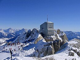 Punta Rocca, 3342 m
 Marmolada - Malga Contrin


See also
- Golden age of alpinism
- Italian front (World War I)
- List of Italian regions by highest point
- White Friday (1916)
- White War
References
- "Europe Ultra-Prominences". Peaklist.org. Retrieved 2014-05-24.
- Reisach, Hermann (2001). "Beatrice Tomasson and the South Face of the Marmolada" (PDF). Alpine Journal: 105–113. Retrieved 8 April 2014.
- "Italian glacier collapse kills seven". BBC News. 2022-07-03. Retrieved 2022-07-05.
- Reuters, Story by. "Italian Alps glacier collapse death toll rises to 9, with 3 still missing". CNN. Retrieved 2022-07-07.
- Tragedia sulla Marmolada: i corpi recuperati sono dieci, manca solo Nicolò Zavatta
External links
- Computer generated summit panoramas North South Index
- Marmolada on Hike.uno
Authority control | |
|---|---|
| General |
|
| National libraries | |
На других языках
[de] Marmolata
Die Marmolata (italienisch Marmolada, ladinisch Marmoleda, der Name soll von der Ähnlichkeit des Felsens mit Marmor herrühren) ist der höchste Berg der Dolomiten und Teil der Marmolatagruppe. Die Marmolata ist ein westöstlich verlaufender Gratrücken, der von der Punta Penia (3343 m s.l.m.) über die Punta Rocca (3309 m s.l.m.) und die Punta Ombretta (3230 m s.l.m.) zum Pizzo Serauta (3035 m s.l.m.) und der Punta Serauta (3069 m s.l.m.) führt. Dieser Gratrücken bricht nach Süden in einer geschlossenen, zwei Kilometer breiten und bis zu 800 Meter hohen Steilwand ins Ombrettatal ab. Die auf der Nordseite zum Passo Fedaia vergleichsweise sanft abfallende Flanke trägt den einzigen größeren Gletscher der Dolomiten (Ghiacciaio della Marmolada).- [en] Marmolada
[es] Marmolada
Marmolada (Ladino: Marmoleda, alemán: Marmolata) es una montaña en el noreste de Italia (justo al este de Trento) y la montaña más alta de los Dolomitas (una sección de los Alpes).[fr] Marmolada
La Marmolada (ladin : Marmoleda, allemand : Marmolata) est le plus haut sommet des Dolomites. Culminant à 3 342 ou 3 343 mètres, elle est également appelée la « reine des Dolomites »[2],[3].[it] Marmolada
La Marmolada (detta la Regina delle Dolomiti, Marmolèda in ladino e Marmolata in tedesco) è un gruppo montuoso[1] delle Alpi orientali (Dolomiti) al confine tra la provincia di Trento e la provincia di Belluno, il più alto delle Dolomiti stesse, raggiungendo la quota massima con la Punta Penia (3.343 m), delimitata ad oriente dalla Val Pettorina e ad occidente dalla Val di Fassa, con altre importanti vallate interne al gruppo (da est a ovest): la Val Contrin, la Val di Grepa e la Val San Nicolò.[ru] Мармолада
Мармолада (Мармолата, итал. Marmolada, ладинск. Marmoleda, нем. Marmolata) — гора на северо-востоке Италии (к востоку от Тренто), самая высокая гора Доломитовых Альп. Это часть гряды, которая тянется с запада на восток. На западе гора разрывается крутыми обрывами, формируя каменную стену длиной несколько километров. На севере находится относительно пологий ледник Мармолада.Другой контент может иметь иную лицензию. Перед использованием материалов сайта WikiSort.org внимательно изучите правила лицензирования конкретных элементов наполнения сайта.
WikiSort.org - проект по пересортировке и дополнению контента Википедии