geo.wikisort.org - Mountains
Monte Baldo (German: Waldberg) is a mountain range in the Italian Alps, located in the provinces of Trento and Verona. Its ridge spans mainly northeast-southwest, and is bounded from south by the highland ending at Caprino Veronese, from west by Lake Garda, from north by the valley joining Rovereto to Nago-Torbole and, from east, the Val d'Adige.
| Monte Baldo | |
|---|---|
| Waldberg | |
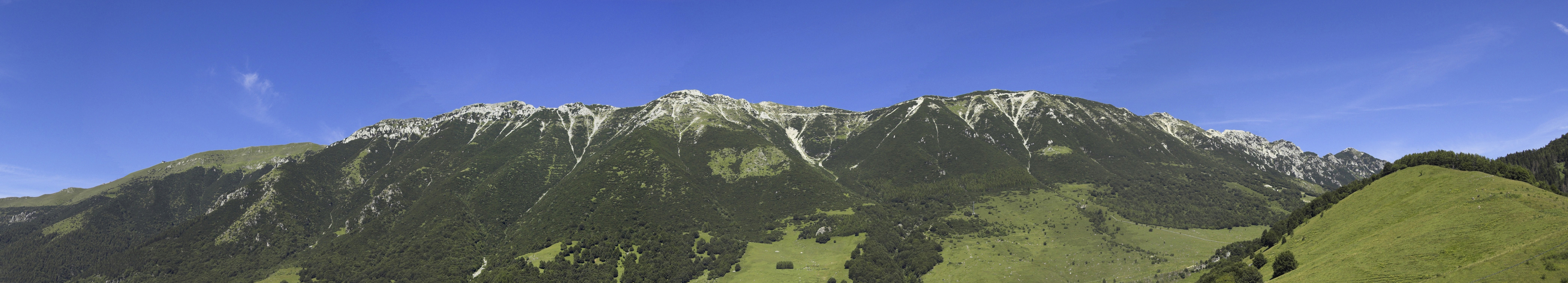
 Monte Altissimo di Nago in the Monte Baldo range | |
| Highest point | |
| Elevation | 2,218 m (7,277 ft)[1] |
| Prominence | 1,950 m (6,400 ft)[2] |
| Listing | Ultra |
| Coordinates | 45°43′35″N 10°50′38″E[2] |
| Geography | |
 Monte Baldo Italy | |
| Location | Veneto, northern Italy |
| Parent range | Alps, Brescia and Garda Prealps |
| Climbing | |
| Easiest route | rock/snow climb |
The name derives from the German Wald ("forest"); it appears for the first time in a German map in 1163. The Peace Trail (it: Sentiero della Pace), one of the most important long distance trails in Northern Italy, leads over the range. The ridge is reachable through a cable car from the nearby town of Malcesine, on the shore of Lake Garda.
Morphology
Mount Baldo is characterized by a geographical identity, a ridge parallel to Lake Garda, which stretches for 40 kilometres (25 miles), between the lake to the west and Val d'Adige to the east, and on the south it is bounded by plain Caprino and North Valley Loppio. Mount Baldo reaches its maximum elevation of 2,218 m with the Cima Valdritta, and its minimum elevation of 65 m on Lake Garda. Other prominent peaks in the range are Monte Altissimo di Nago (2,079 m), Cima del Longino (2,180 m), Cima delle Pozzette (2,132 m) and Punta Telegrafo (2,200 m).
See also
References
- "Cima Valdritta, Italy". Peakbagger.com. Retrieved 2014-07-28.
- "European Ultra-Prominences". Peaklist.org. Retrieved 2014-07-28.
Images


Authority control | |
|---|---|
| General |
|
| National libraries | |
На других языках
[de] Monte Baldo
Der Monte Baldo ist ein zwischen Gardasee und Etsch gelegener, etwa 30 Kilometer langer Bergrücken, der zum Gebirgszug der Gardaseeberge zählt.- [en] Monte Baldo
[fr] Monte Baldo
Le Monte Baldo est un chaînon des montagnes autour du lac de Garde, dans les Alpes, s'élevant sur la rive orientale du lac de Garde, en Italie (à cheval entre le Trentin-Haut-Adige et la Vénétie) et bordant au sud la plaine vénitienne de Caprino Veronese, au nord la vallée qui relie Rovereto à Nago-Torbole et à l'est la Vallagarina. Il culmine à 2 218 m d'altitude à la Cima Valdritta.[it] Monte Baldo
Il monte Baldo (il nome in epoca romana mons Polninus, deriva dal tedesco Wald, ovvero bosco[1], Bald in tedesco medievale) è un massiccio montuoso delle Prealpi Gardesane di altezza massima pari a 2 218 m, esteso da nordest-sudovest, compreso tra le province di Trento e Verona (tra i territori comunali di San Zeno di Montagna, Avio, Caprino Veronese, Ferrara di Monte Baldo, Brentonico, Nago-Torbole, Malcesine e Brenzone), confinante a sud con la pianura padano-veneta all'altezza di Caprino Veronese, a ovest con il lago di Garda, a nord con la valle che congiunge Rovereto a Nago-Torbole e ad est con la Vallagarina.Другой контент может иметь иную лицензию. Перед использованием материалов сайта WikiSort.org внимательно изучите правила лицензирования конкретных элементов наполнения сайта.
WikiSort.org - проект по пересортировке и дополнению контента Википедии